Friday Dec. 1, 2006

Quiz #4 will be returned on Monday together with up-to-date grade summaries.  You will find out on Monday whether you have to take the final exam or not.

The final exam for this class is scheduled for Friday Dec. 8, 2 - 4 pm in ILC 150.  A final exam study outline is now available online.  Note a 2 hour "marathon" review is scheduled for next Thursday afternoon (Dec. 7) from 2-4 pm in EDUC 353.

If you would like to take the final exam with the T Th class on Thursday Dec. 14 (8 am - 10 am) you may do so.  You will need to add your name to the signup sheet in class next week.


We covered some new material on hurricanes today.
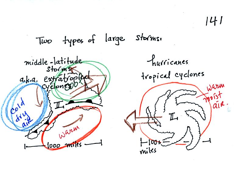
You'll find the following sketch comparing a middle latitude storm and a hurricane on p. 141 in the photocopied notes.


Some of the similarities and differences (mostly differences) between middle latitude storms and hurricanes are noted in the following table
Differences
Similarities
  Differences 
Found at middle latitudes (30 to 60 latitude)
Can form over land or water
The term cyclone refers to winds spinning around low pressure,
both storms have low pressure centers (the low pressure becomes high pressure at the top of a hurricane)

Found in the tropics (5 to 20 latitude)
Only form over warm ocean water

Movement is from west to east Upper level divergence cause lower the surface pressure
and cause both types of storms to intensity
Movement is from east to west
Warm and cold air masses brought together by converging winds
Warm moist air mass only
Storm winds intensify with altitude

Storm winds weaken with altitude
Strongest storms usually occur in the winter

Strongest storms in the last summer to early fall


Hurricanes form over warm ocean water.  The warm layer of water must be fairly deep to contain enough energy to fuel a hurricane and in order that mixing doesn't bring cold water up to the ocean surface.  The atmosphere must be unstable so that thunderstorms can develop.  Hurricanes will only form when there is very little or no vertical wind shear (changing wind direction or speed with altitude).  Hurricanes don't form at the equator because there is no Coriolis force there. 

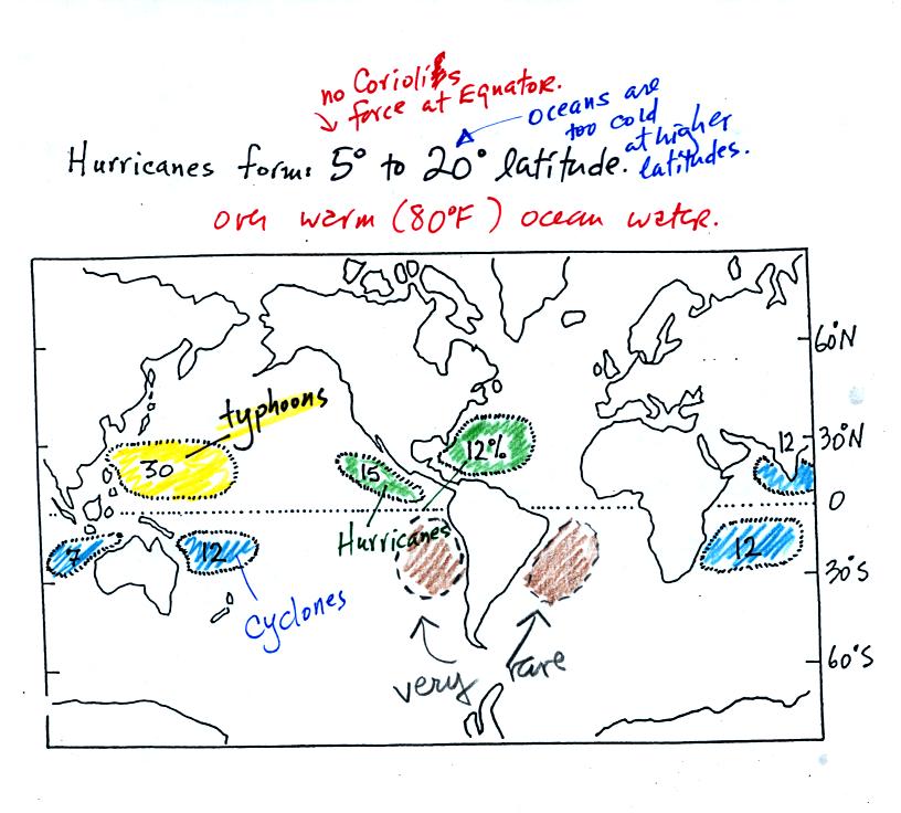
The figure above shows the relative frequency of tropical cyclone development in different parts of the world. 
The name hurricane, cyclone, and typhoon all refer to the same type of storm (tropical cyclone is a general name that can be used anywhere).  In most years the ocean off the coast of SE Asia is the world's most active hurricane zone.  Super typhoon Dorian moved across the Philippine islands this past week killing a few hundred people.  Hurricanes are very rare off the east and west coasts of South America.

Note that more tropical cyclones form off the west coast of the US than off the east coast.  The west coast hurricanes don't generally get the same attention, because they move away from the coast and usually don't present a threat to the US.  The moisture from these storms will sometimes be pulled up into the southwestern US where it can lead to heavy rain and flooding.


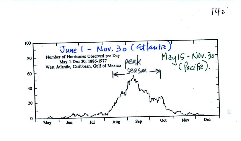
This figure shows when hurricanes are most common in the Atlantic.  Hurricane season in the Atlantic officially runs from June 1 through to November 30.  The peak of hurricane season is in September.  Hurricane season in the Pacific begins on May 15 and runs through Nov. 30.


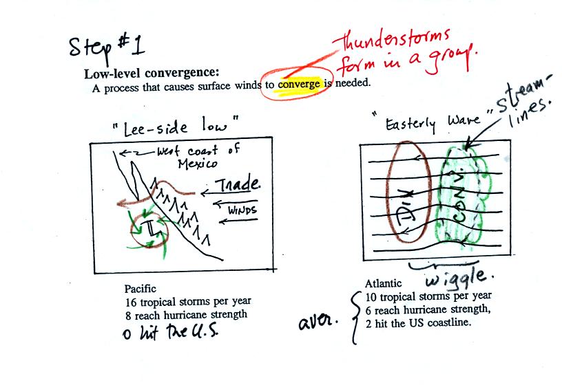
Some kind of meteorological process that produces low level convergence is needed to initiate a hurricane.  One possibility, and the one that fuels most of the strong N. Atlantic hurricanes, is an "easterly wave."  This is just a "wiggle" in the wind flow pattern.  Easterly waves often form over Africa or just off the African coast and then travel toward the west across the N. Atlantic.  Winds converge as they approach the wave and then divergence once they are past it.  The convergence will cause air to rise and thunderstorms to begin to develop. 

In some ways winds blowing through an easterly wave resembles traffic on a multi lane highway.  Traffic will back up as it approaches a section of the highway with a closed lane.  Once through the "bottleneck" traffic will begin to flow more freely.

In an average year, in the N. Atlantic, there will be 10 named storms (tropical storms or hurricanes) that develop during hurricane season.  2005 was, of course, a very unusual year.  There were 28 named storms in the N. Atlantic in 2005.  That beat the previous record of 21 names storms that had been set in 1933.  Of the 28 named storms, 15 developed into hurricanes.

Winds blowing over mountains on the west coast of Mexico will sometimes form a surface low on the downwind side of the mountains.  Note there are generally a few more tropical storms and hurricanes in the E. Pacific than in the N. Atlantic.  They generally move away from the US coast, though the Hawaiian Islands are sometimes affected.

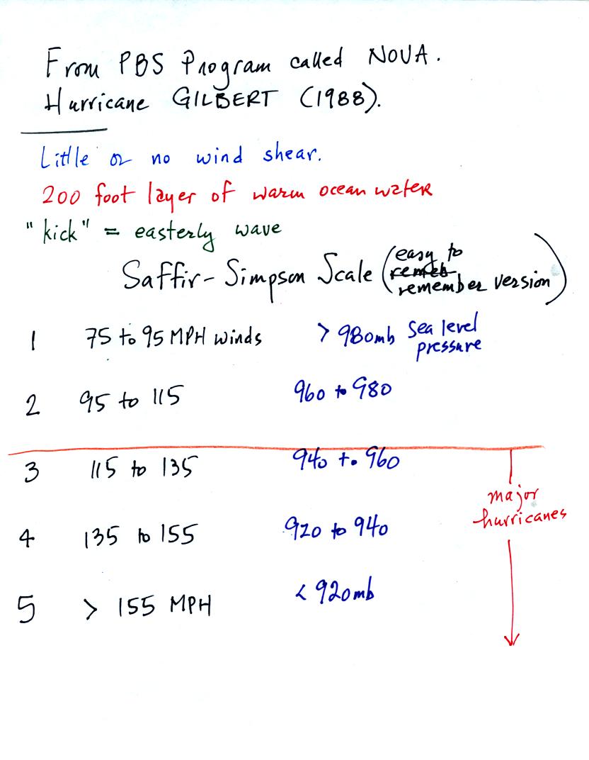
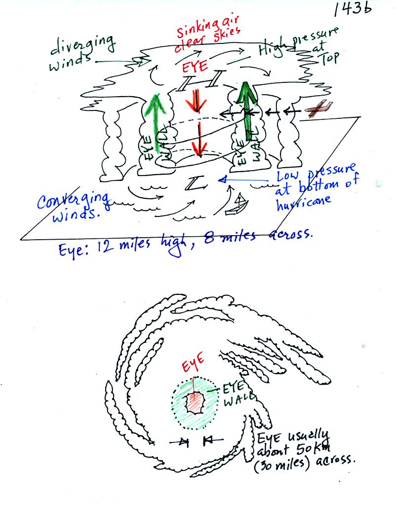
A 20 minute segment from a NOVA program (PBS network) on hurricanes was shown at the end of class.  A film crew was on board a NOAA reconnaissance plane as it flew into the narrow eye of hurricane GILBERT.  Gilbert set the record low sea level pressure reading for the Atlantic ocean (888 mb).  That record stood until the 2005 hurricane season when WILMA set a new record of 882 mb.  The world record low sea level pressure, 870 mb, was set in a SE Asian typhoon in 1979.

The following notes were projected during the video tape.  They are reproduced here without any comments as we will go over this materials again next week.