Wednesday Nov. 8, 2006
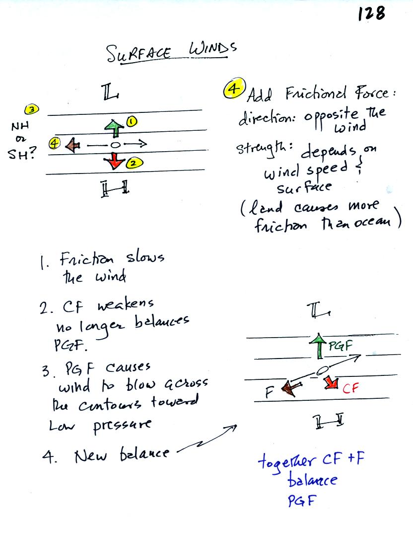
Now we'll look briefly at surface winds. We must now
include the frictional force.
In the figure at top left, we start at Point 1 by drawing in the
pressure gradient force (perpendicular to the contour lines and
pointing toward low pressure). Then we can draw in an equal and
oppositely directed CF so that the net force will be zero. Since
the
CF is the right of the wind we can say this is a NH chart.
The frictional force will always point in a direction opposite the
wind. Friction always try to slow moving objects (it doesn't
cause you
to speed up on your bicycle or to veer suddenly to the right or
left).
The strength of the frictional force depends on wind speed (stronger
when the winds are fast and zero when the wind isn't blowing at
all).
Friction also depends on the type of surface the wind is blowing over.
The friction will slow the wind. That in turn weakens the CF
(remember
the strength of the CF depends on wind speed. The CF no longer
balances the PGF, and the wind turns slightly and blows across the
contours toward low pressure. On a chart like this with straight
contours you end up with a new balance among the forces. Together
the
CF + F = PGF. The wind will blow in a straight line at constant
speed
across the contours toward low pressure.
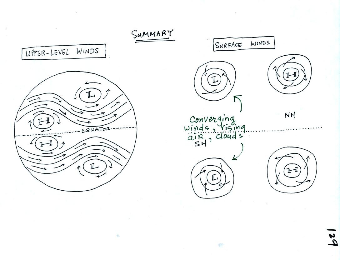
This figure summarizes everything we have done. The upper level
winds are shown in the figure at left. The upper level winds blow
parallel to the contour lines.
At right surface winds around centers of high and low pressure are
shown. You should remember from early in the semester that winds
blow counterclockwise and inward around low pressure in the NH.
They blow clockwise and outward around high pressure.
In the southern hemisphere the directions of spin change (clockwise
around low and counterclockwise around high). Winds still blow
converge into low pressure and diverge from centers of high
pressure. This means that rising air (which expands and cools)
and clouds will be found with centers of low pressure in both the
northern and southern hemispheres.
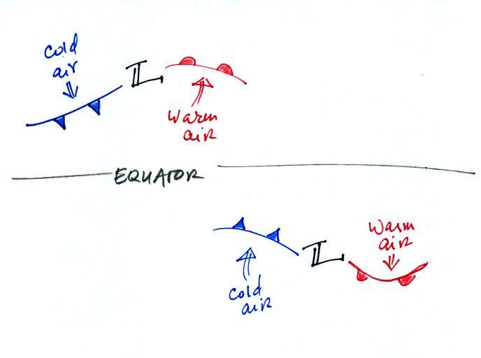
This figure compares middle latitude storms in the NH and
SH. In
the NH cold air moves southward from higher latitudes on the west side
of the low, warm air moves northward on the east side. The fronts
spin
counterclockwise around the low pressure center.
In the SH the cold air is found in the south and moves northward, again
on the west side of the low. Warm air moves southward on the
east side of the low. The fronts rotate clockwise around the low.
Differences in temperature such
as might develop between a coast and
the ocean or between a city and the surrounding country side can create
horizontal pressure differences. The horizontal pressure gradient can
then produce a wind flow pattern known as a thermal circulation.
These are generally relatively small scale circulations and the
pressure gradient is so much stronger than the Coriolis force that the
Coriolis force can be ignored. We will learn how thermal
circulations develop and then apply to concept to the earth as a
whole
in order to understand large global scale pressure and wind
patterns. What follows is a
slightly different version of what you will find on p. 131 in the
photocopied class notes.
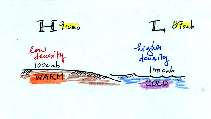
A beach will often become much warmer than the nearby
ocean during
the day (the sand gets hot enough that it is painful to walk across in
barefeet). Pressure will decrease more slowly with increasing
altitude in the warm low density
air than in the cold higher density
air above the ocean. Even when the sea level pressures are the
same over the land and water (1000 mb above) an upper level pressure
gradient can be created.
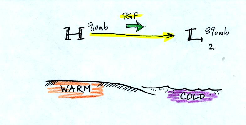
The upper level pressure gradient force will
cause upper level winds to
blow from H (910 mb) toward L (890 mb).
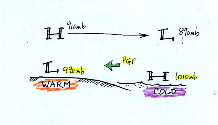
The movement of air above the ground can affect the
surface
pressures. As air above the ground begins to move from left to
right, the surface pressure at left will decrease (from 1000 mb to 990
mb
in the picture above). Adding air at right will increase the
surface pressure there (from 1000 to 1010 mb). This creates a
surface
pressure gradient and surface winds begin to blow from right to left
(the opposite of what is going on above the ground).
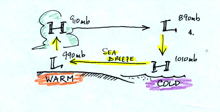
You can complete the picture by adding rising air
above the surface low
and sinking air above the surface high. Because the surface winds
come from the ocean they are referred
to as a sea breeze. These
winds would probably be pretty moist so clouds would be likely over
land above the surface low.
At some point during the night, the ocean often ends up warmer than the
land. The thermal circulation reverses direction. The
surface winds are then called a land breeze and clouds and rain form
out over the ocean.