October 18, 2006
Even though Quiz #3 is still two weeks away, the Quiz #3 Study Guide has made an initial
appearance. You'll find some sample humidity questions embedded
in the study guide.
The two newest Optional Assignments
were handed out today. They are both due, at the beginning of
class, next Wednesday (Oct. 25). You might review the online
notes on the Controls of Temperature
before starting to work on Optional Assignment #4.
You might
have a look at the last of the example problems that we did in Monday's
class (air temperature = 90 F, dew point temperature 50 F, mixing ratio
= 7.5 g/kg, relative humidity = 25%). We will see how some of the
moisture in air with those characteristics could be removed. I.e.
we will see how moist air can be dried out.
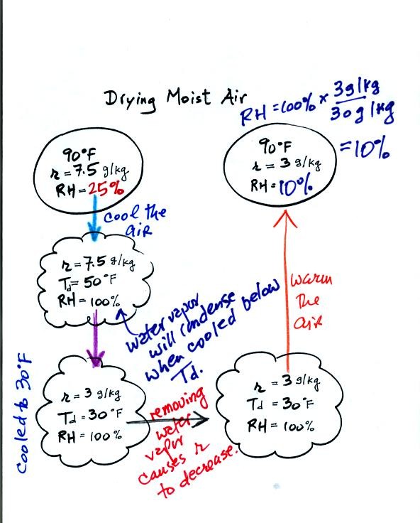
We imagine cooling the moist air to its dew point. The relative
humidity
reaches 100% at that point. Then the air is cooled below the dew
point, to
30 F. The 30 F air can't hold the 7.5 g/kg of water vapor that
was originally found in the air. The excess moisture must
condense (we will assume it falls out of the air as rain or
snow). When air reaches 30 F it contains less than half the
moisture (3 g/kg) that it originally did (7.5 g/kg). Next the 30
F air is warmed back to 90 F, the starting temperature. The air
now
has a RH of only 10%.
Drying moist air is like wringing moisture from a wet sponge.
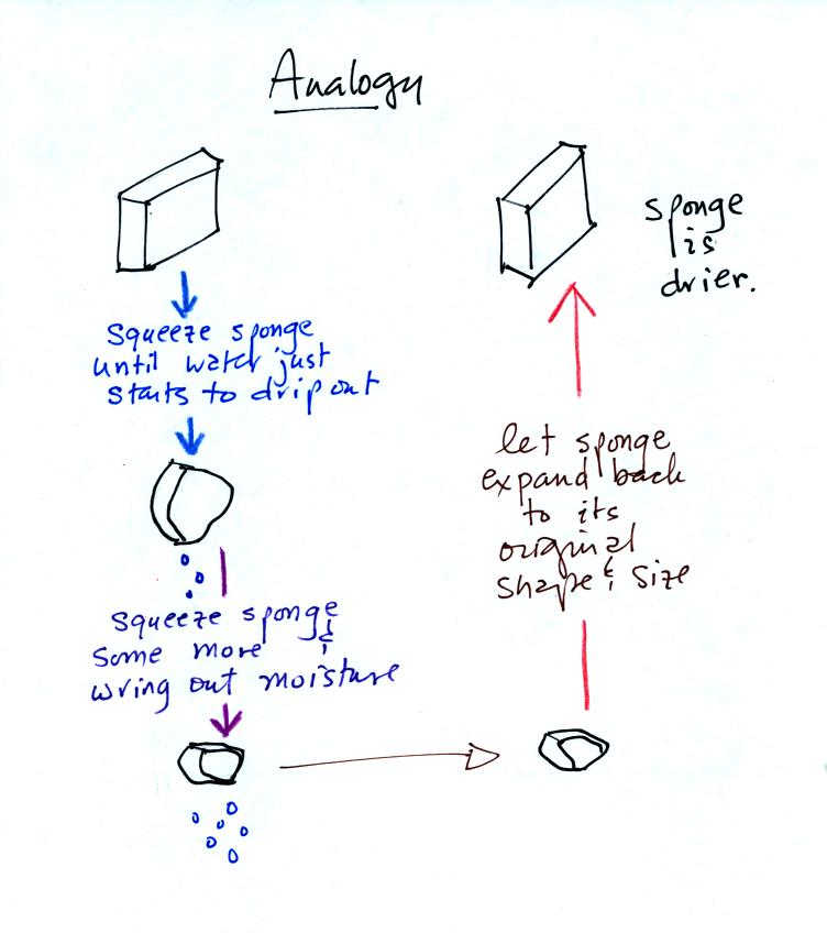
Cooling moist air below the dew point is kind of
like squeezing out or wringing out a wet sponge. You start to
squeeze the sponge and nothing happens at first (that's like cooling
the air, the mixing ratio stays constant as long as the air doesn't
lose any water vapor). Eventually water will start to drop from
the sponge (with air this is what happens when you reach the dew point
and continue to cool the air below the dew point). Then you let
go of the sponge and let it expand back
to its orignal shape and size (the air warms back to its original
temperature). The sponge (and the air) will be drier than when
you started.
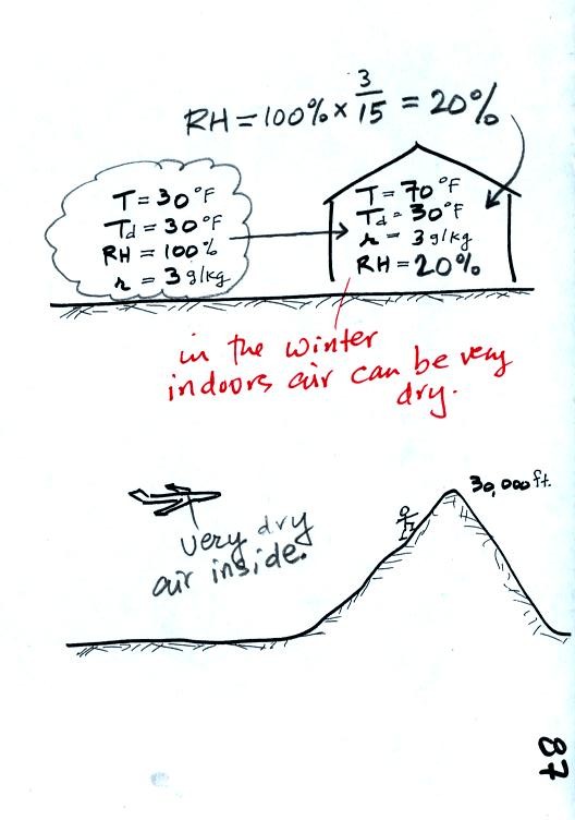
These two figures show where this kind of thing can
occur. In the
winter cold air is brought inside your house or apartment and
warmed. Imagine 30 F air with a RH of 100 % brought inside and
warmed to 70 F. The RH will decrease to 20%.
The air in an
airplane comes from outside the plane. The air outside the plane
is very cold (-50 F perhaps) and contains very little water
vapor (even if the -50 F air is saturated it will contain essentially
no water vapor). When brought inside and warmed to a
comfortable
temperature the RH of the air in the plane will be very close 0%.
Actually I suspect the ventilation system in the plane will add
moisture to the
air so that it doesn't get that dry.
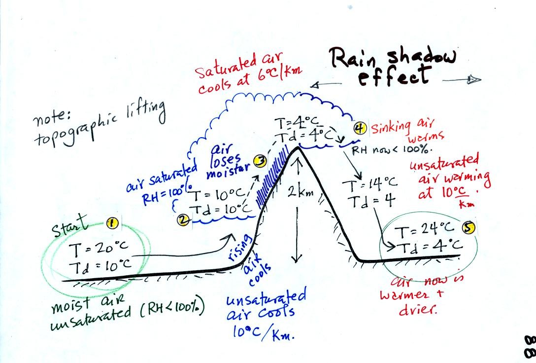
Here's an important cooling and drying out moist
air
example.
We start with some moist but unsaturated air at Point 1 (the numbers were added after class).
As it is moving toward the right the air runs into a mountain and
starts to rise. This is one of the 4 ways of causing air to rise
(the other three were convergence, convection, and fronts).
Unsaturated air cools 10 C for every kilometer of altitude gain.
This is known as the dry adiabatic lapse rate. So in rising 1 km
the air will cool to its dew point.
The air becomes saturated at Point 2, you would see a cloud
appear. Rising saturated air cools at a slower rate than
unsaturated air. We'll use a value of 6 C/km (an average value
for the moist adiabatic lapse rate). The air cools from 10 C to 4
C in next kilometer up to the top of the mountain. Because the
air is being cooled below its dew point at Point 3, some of the water
vapor will condense and fall to the ground as rain.
At Point 4 the air starts back down the right side of the
mountain. Sinking air warms. As soon as the air starts to
sink and warm, the relative humidity drops below 100% and the cloud
evaporates. The sinking air will warm at the 10 C/km rate.
At Point 5 the air ends up warmer (24 C vs 20 C) and drier (Td =
4 C vs Td = 6 C) than when it started out. The downwind side of
the mountain is referred to as a "rain shadow" because rain is less
likely there than on the upwind side of the mountain.
The air that arrives in Arizona from the west coast is often dry
because it has travelled up and over the Sierra Nevada mountains in
California and the Sierra Madre mountains further south in Mexico.
In the
second part of the class we took a detour and learned a little bit
about scattering of light.
Scattering will come up again in class on Friday.