Friday Oct. 27, 2006
The Experiment #3 reports are due next Monday. If you
haven't
returned your materials yet, you will now have to come by my office
(PAS 588) to leave your materials and to pick up the supplementary
information sheet. The Expt. #2 revised reports and the
Scientific Paper report are also due next Monday.
Last
Wednesday we saw how the collision coalescence process turns cloud
droplets into precipitation size particles. The
collision-coalescence process works in warm clouds that just contain
water droplets.

Rain, drizzle, and virga are really the only types of
precipitation that you would expect to fall from a warm cloud.
The Ice Crystal process works in cold clouds which are found in
many more locations than warm clouds. The mixed phase portion of
a cold cloud is shown in the figure below. In the mixed phase
region you find both supercooled water droplets and also ice crystals.
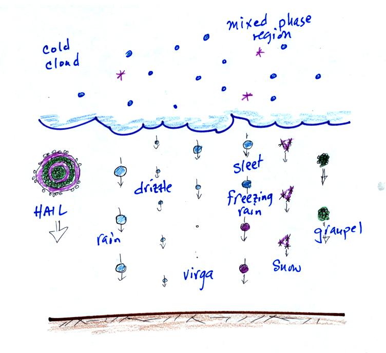
We are going to see that a variety of different types of ice
particles can form in a cold cloud. An that is just the beginning of
the story; look at all the different types of precipitation that can
fall from
this cloud.
Now just
what
happens inside the mixed phase region in a cold cloud? You will
find most of the following on pps 101 and 101a in the photocopied class
notes.

In a cold cloud the supercooled water droplets are in
equilibrium with
their surroundings. This means the air must be moist enough to
provide enough condensation to balance evaporation from the droplets (3
arrows of evaporation from each drop above is balanced by 3 arrows
of condensation).
In Step 2, an ice crystal at the same temperature won't sublimate as
quickly as a supercooled water droplet. It is a bigger step to go
from solid to gas than from liquid to gas (see figure below).
There doesn't need to be as much moisture in the air to keep an ice
crystal in equilibrium with it surroundings.
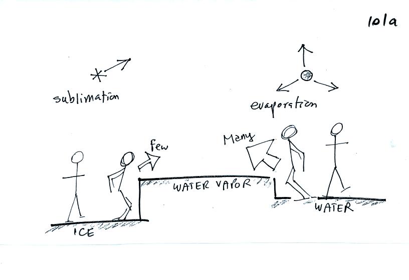
Most of the students in a class would be able to make a 1
foot vertical
jump. The rate of evaporation from a supercooled water droplet is
relatively high because many of the water molecules have the energy
needed to evaporate.
Only a few students would be able to make a 3 foot vertical jump, just
as fewer ice molecules will have the energy needed to sublimate.

In a cold cloud ice crystals are found in the very moist air
needed to
keep supercooled water droplets in equilibrium. Water will
condense onto the water droplets and be deposited onto the ice crystals
at equal rates (see figure below). The ice crystal will grow
under these circumstances. This is what gets the ice crystal
process started.
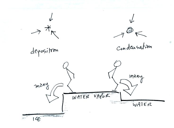
Equal numbers of students could jump down the 1 and 3 foot
drops, just
as water vapor condenses onto the water droplet and ice crystal at
equal rates.
Once it
gets started, ice crystal process can produce a variety of types of
particles inside the cloud.
We'll look at some of the possibilities next.
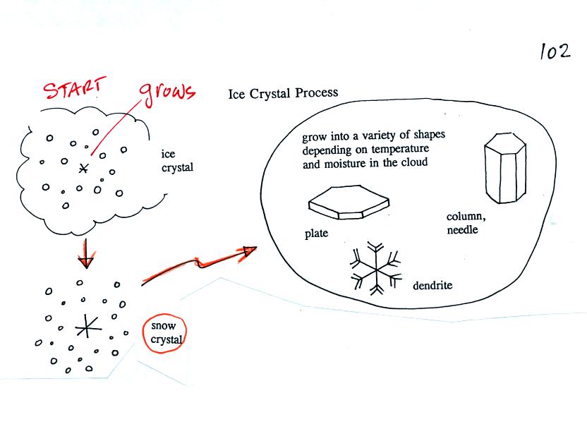
Once an ice crystal has grown a little bit it becomes a snow
crystal. Snow crystals can have a variety of shapes (called
crystal habits, sketched above) depending on the conditions
(temperature and moisture) in the cloud. Dendrites are the most
common because they form where there is the most moisture available for
growth. With more raw material available it makes sense there
would be more of this particular snow crystal shape.
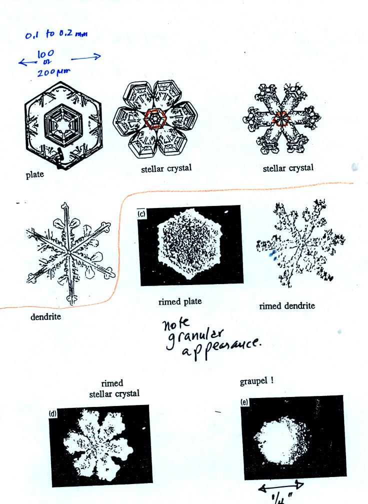
Here are some actual photographs of snow crystals (taken
with a
microscope). You'll find even better photographs at
www.snowcrystals.com

A variety of things can happen once a snow crystal
forms. First
it can break into pieces, then each of the pieces can grow into a new
snow crystal. Because snow crystals are otherwise in rather short
supply, ice
crystal multiplication is a way of increasing the amount of
precipitation that ultimately
falls from the cloud.
This is incidentally the idea behind cloud seeding, to increase the
number of ice crystals and hopefully the amount of precipitation.
A substance called silver iodide is often used. Silver iodide is
one of the relatively rare materials that can act as an ice crystal
nucleus. However it is possible to "overseed" a cloud and end up
with too many ice crystals. Then they all fight for a limited
amount of water vapor and, as a result, do not get very big.
Overseeding a cloud could decrease the precipitation from a cloud.
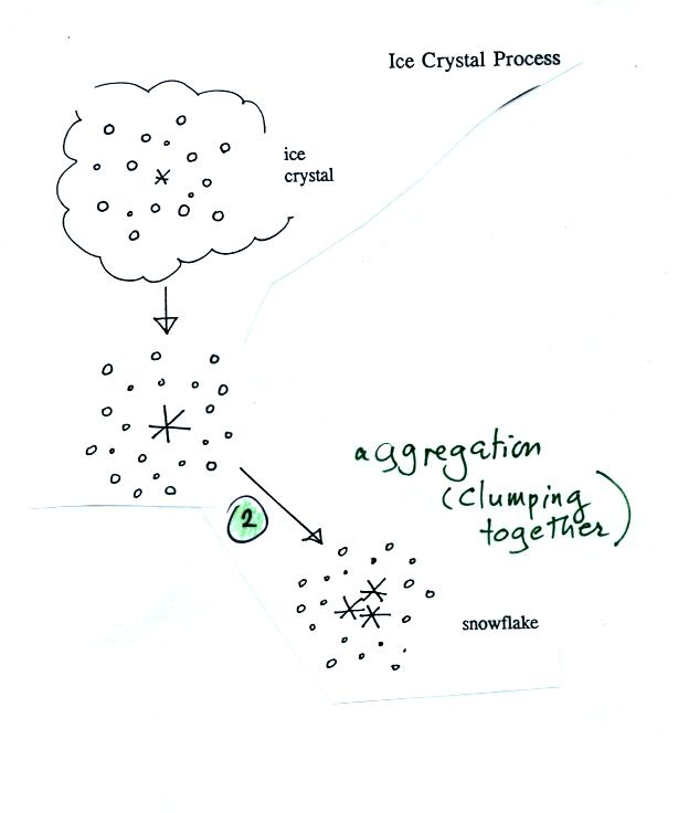
Several snow crystals can collide and stick together to form
a
snowflake. Snow crystals are small, a few tenths of a millimeter
across. Snowflakes can be much larger and are made up of many
snow crystals stuck together. The sticking together or clumping
together of snow
crystals is called aggregation.

Snow crystals can collide with supercooled water
droplets. The
water droplets may stick and freeze to the snow crystal. This
process is called riming or accretion (note it is really the same idea
as collision and coalescence). If a snow crystal collides with
enough water droplets it can be completely covered with ice. The
resulting particle is called graupel (or snow pellets). Graupel
is sometimes mistaken for hail and is called soft hail. Rime ice
has a frosty milky white appearance. A graupel particle resembles
a miniature snow ball. Graupel particles often serve as the
nucleus for a hailstone.
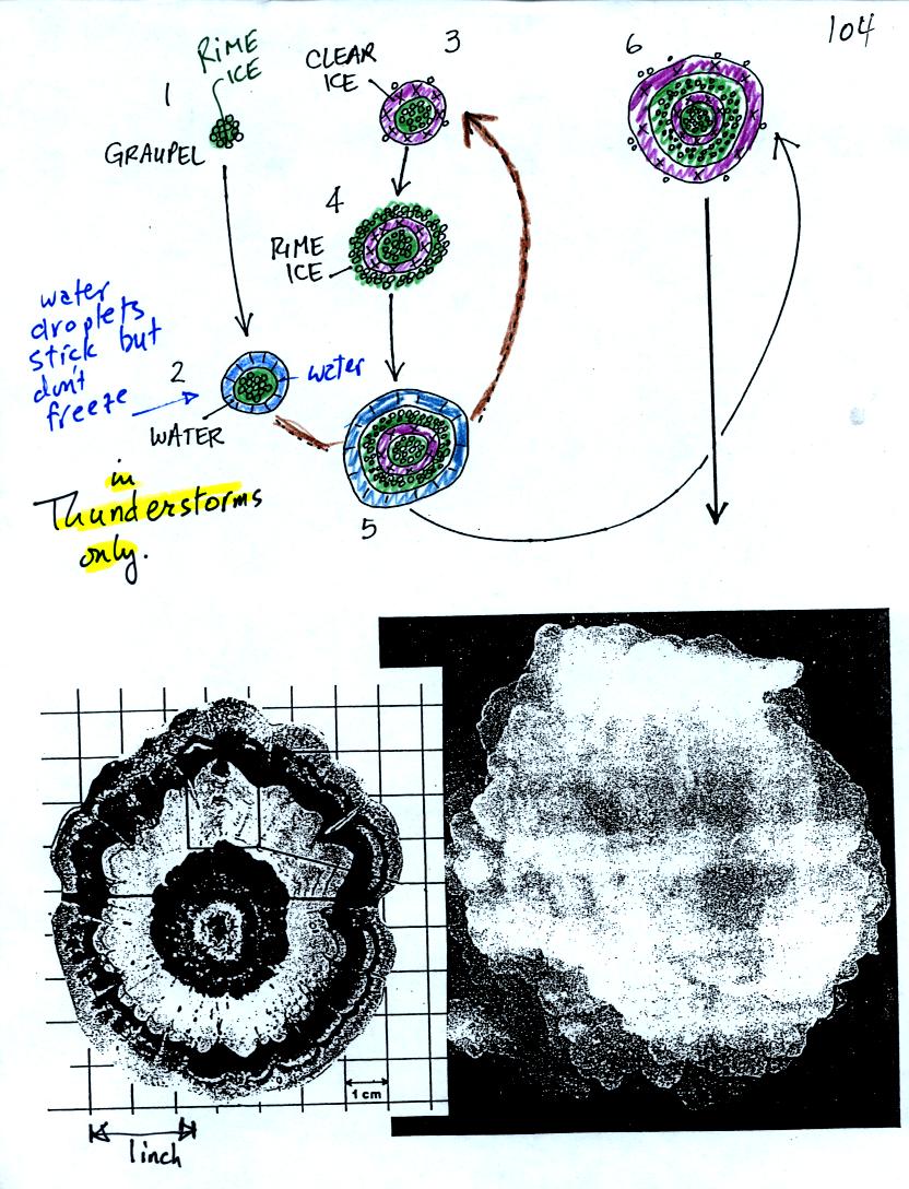
Hail forms in thunderstorms with very strong updrafts.
In the
figure above the hailstone starts with a graupel particle (colored
green to represent rime ice). The graupel falls or gets carried
into a part of the cloud where it collides with a large number of
supercooled water droplets which stick to the graupel but don't
immediately freeze. The graupel gets coated with a layer of
water (blue). The particle then moves into a colder part of the
cloud
and the water layer freeze producing a layer of clear ice (the clear
ice, colored violet, has a distinctly different appearance from the
milky white rime
ice). The particle then can pick up a new layer of rime ice,
followed by another layer of water which subsequently freezes to
produce a layer of clear ice.
Large hailstones can be composed of many alternating layers of rime and
clear ice. An unusually large hailstone (2.5 to 3 inches in
diameter) has been cut in
half to shown the different layers of ice.

The ice crystal process can produce a variety of types of
precipitation
particles inside the cloud. Once the precipitation particle falls
from the cloud it change in a variety of ways before it reaches and
hits the ground.
In the example above at left the particle first melts and then
evaporates before reaching the ground. Rain that evaporates
before reaching the ground is called virga.
A similar thing can
happen with snow crystals or snow flakes. They sublimate away;
the streamers of falling precipitation are called fall streaks (I said
I would accept the name virga for this process also since it is the
same overall idea). You'll see white streamers falling from
cirrus clouds sometimes.
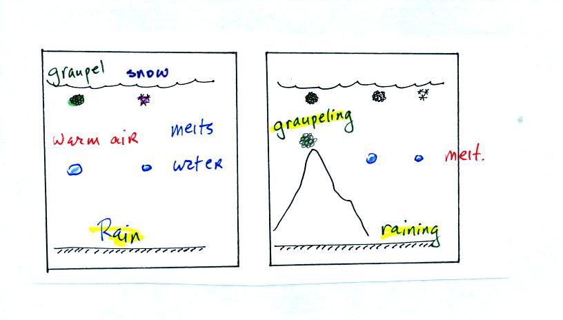
The frozen precipitation particles produced by the ice
crystal process
(graupel or snow) can melt before reaching the ground. This would
be rain (or drizzle if the drops are small). Rain in most
locations at most times of the year starts out as frozen precipitation
(even in Tucson in the summer).
If you are on a mountain top you might see some of the frozen
precipitation before it melts. You might see graupel falling from
a summer thunderstorm, for example, while the people in the valley only
observe rain.

Sometimes the frozen precipitation will melt and then fall
into a thick
layer of cold air and refreeze. The resulting particle is called
sleet (or ice pellets). The clear ice in sleet is noticeably
different from the frosty, milky white, rime ice in graupel.
Rain that falls into a shallow cold air layer and freezes after
reaching the ground is called freezing rain. It is nearly
impossible to drive during one of these "ice storms." Sometimes
the coating of ice is heavy enough that power lines are brought down
and branches on trees are broken. It sometimes takes several days
for power to be restored.