Tues., Dec. 5, 2006
Today is the last day for this class. The final exam is a little
over a week from now (Thursday morning Dec. 14 from 8 am to 10 am in
ILC 150). The Final Exam
Study Outline is still available online. A 2 hour review is
scheduled for Wednesday afternoon, Dec. 13, from 2 pm to 4 pm in EDUC
353.
Free copies of the Fall 2003 Final Exam (ten questions on this
semester's final exam will come from that exam) were available in class
today. They will also be available at the review and in PAS 588.
A limited number of copies of this semester's quizzes are also
available.
We
finished up some remaining information on hurricanes.
Hurricanes are now alternately given male and female names.
The
names start with A (a male name one year, a female name starting with A
the next year) at the start of
every new storm season. Five letters (Q, U, X, Y, and Z) are not
included in the list. In 2005 in the N. Atlantic they ran out of
letters of the alphabet and 6 Greek characters had to be used (Alpha,
Beta, Gamma, Delta, Epsilon, and Zeta). The last storm of 2005
actually remained active into Jan. 2006.
The list of names repeats every 6 years, though the names of unusually
strong or destructive hurricanes may be retired. There were 5
names retired following the 2005 N. Atlantic hurricane season (Dennis,
Katrina, Rita, Stan, & Wilma).
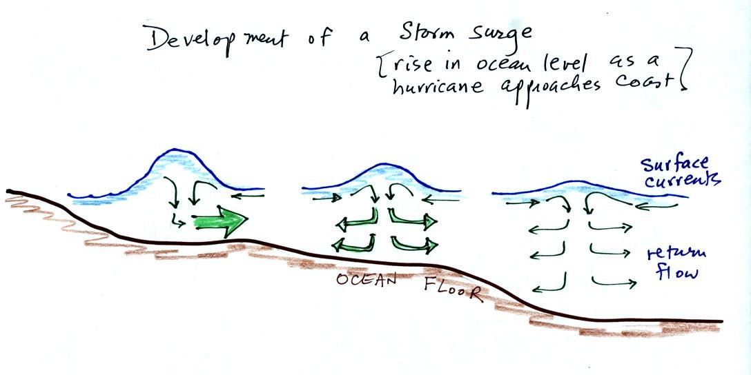
Out at sea, the converging surface winds create surface
currents
in the
ocean that transport water toward the center of the hurricane.
The rise in ocean level is probably only a few feet, though the waves
are much larger. A return flow develops underwater that carries
the water back to where it came from.
As the hurricane approaches shore, the ocean becomes shallower.
The return flow must pass through a more restricted space. A rise
in ocean level will increase the underwater pressure and the return
flow will speed up. More pressure and an even faster return flow
is needed as the hurricane gets near the coast.
Here is a link to the storm surge website
(from the Hurricane Research Division of the Atlantic Oceanographic and
Meteorological Labororatory). It has an interesting animation
showing output from the SLOSH model used to predict hurricane storm
surges.
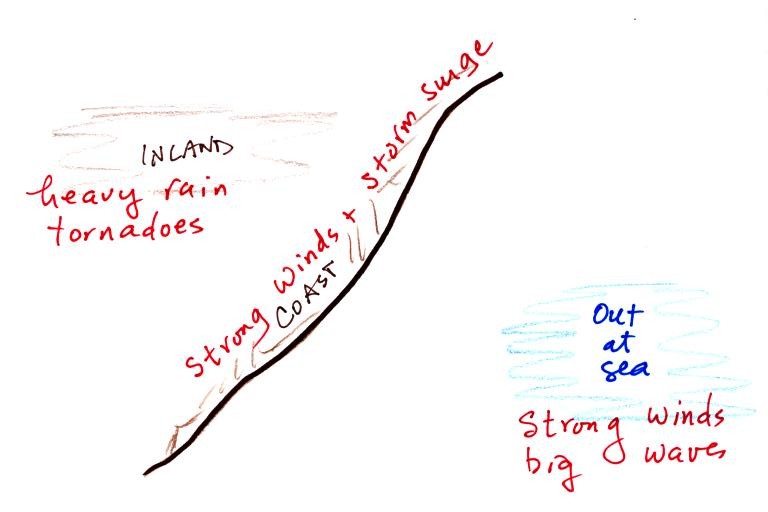
Hurricanes can, of course, be very destructive. Out at
sea the
main hazards are the strong winds and the large waves. The
Perfect Storm by Sebastian Junger describes the sinking of the Andrea
Gail in a strong hurricane like storm in October 1991. The exact
fate of the fishing ship is not known but it may have been turned end
over end by a large wave (pitch poled). Large waves can also
flood a ship and begin to fill it with water.
Along a coast the greatest threat is from the hurricane winds and the
storm surge. Large waves are superimposed on the storm surge.
The hurricanes winds slow quickly as it moves onshore, though
tornadoes may form. The biggest threat is from flooding.
Hurricanes can easily drop a foot or more of rain on an area as they
pass through.
A review
of most of what we covered on hurricanes was prepared for the MWF
section of the class. You can have a look at the review by
clicking here.