Tuesday Sept. 18, 2007
The optional assignments were returned in class today.
The answers are available online.
If you
don't see a grade on your paper you received full credit (0.5 extra
credit) points.
A copy of the Quiz #1 Study Guide was
handed out. This week's quiz will cover material on both the Practice Quiz (~50%) and Quiz #1
(~50%) Study Guides.
The appearance of the Atmospheric Sciences webpage has changed
significantly. Click on the Courses link near the top center of
the page to find the web page for this class.
The Experiment #1 reports and the 1S1P Assignment #1 reports were
collected in class today. It will take about a week to grade the
experiment reports. It will take at least a week to grade all of
the 1S1P reports.
Today we
finish the section of understanding why warm air rises and cold air
sinks. It has been a long 3-step process.

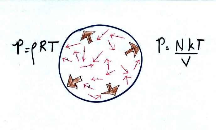
In the first step we learned about the 2 forms of the ideal
gas law
equation which show how the pressure produced by air inside a balloon
depends on variables such as air temperature, air density, number of
air molecules and the volume of the balloon.

In the second step we learned that when you warm a parcel of
air in the
atmosphere, the parcel volume will increase and the air density will
decrease in order to keep the air pressure in the parcel
constant. Cooling a parcel of air causes a decrease in volume and
an increase in air density but pressure stays constant. This is
Charles' Law and allows us to make the association warm air = low
density air and cold air =
high density air.
Now the final step, we must learn about the vertical forces that
operate on a parcel of air in the atmosphere.

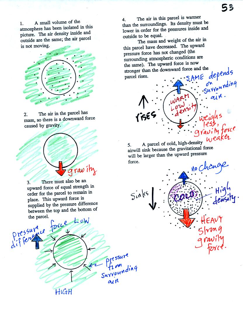
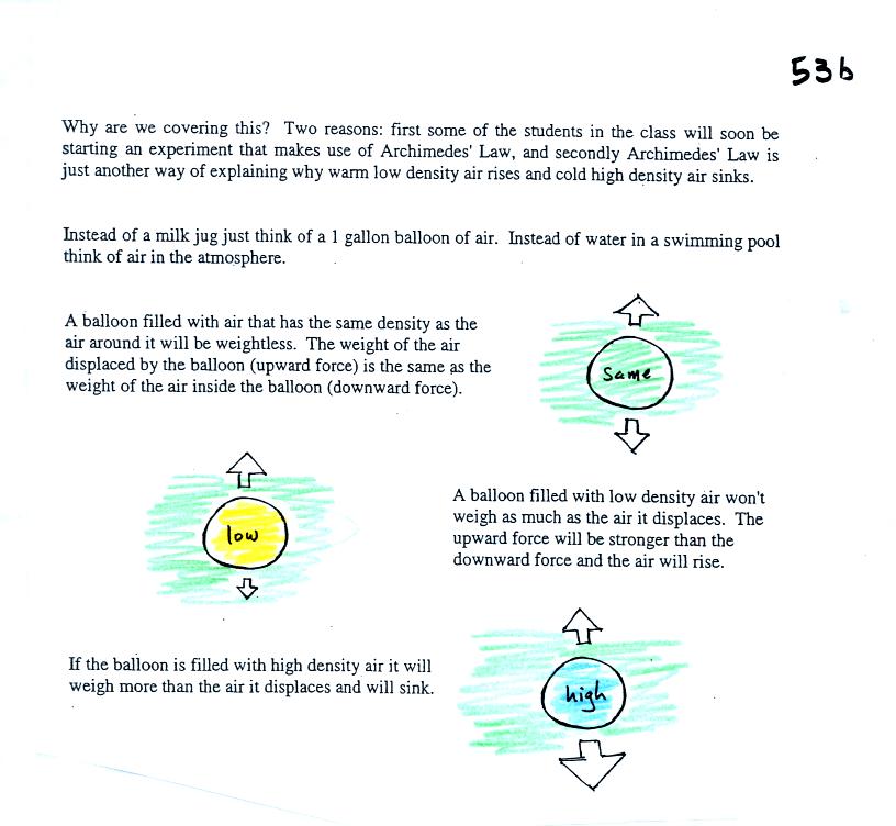
Air has mass and weight When an air parcel has
the same
temperature, pressure, and density as the air around it, the parcel
will remain stationary. With gravity pulling downward on the air,
there must be another force pointing upward of equal strength.
The upward force is caused by pressure differences between the bottom
(higher pressure pushing up) and top of the balloon (slightly lower
pressure pushing down on the balloon).
If the balloon is filled with warm, low density air the gravity force
will weaken (there is less air in the balloon so it weighs less). The
upward pressure difference force (which depends on the
surrounding air) will not change. The upward force will be
stronger than the downward force and the balloon will rise.
Conversely if a balloon is filled with cold high density air, the
balloon gets heavier. The upward pressure difference force
doesn't change. The net force is now downward and the balloon
will sink.

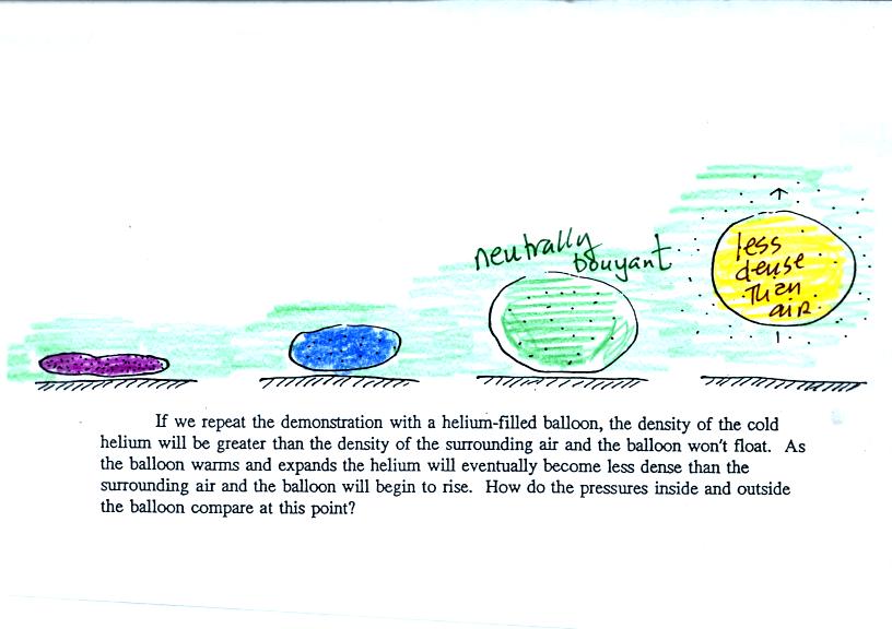
We modified the Charles Law demonstration (performed
in class last Friday). We used a balloon filled with
helium
instead of air (see bottom of p. 54 in the photocopied Class
Notes). Helium is less dense than air even when the
helium has the same temperature as the surrounding air. A
helium-filled balloon doesn't need to warmed up in order to rise.
We dunked the helium-filled balloon in some liquid nitrogen to cool
it
and to cause the density of the helium to increase. When
removed
from the liquid nitrogen the balloon can't rise, the gas inside is
denser than the surrounding air (the purple and blue balloons in the
figure above). As the balloon warms and expands
its density decreases. The balloon at some point has the same
density as the air around it (green above) and is neutrally
bouyant. Eventually the balloon becomes less dense that the
surrounding air (yellow) and floats up to the ceiling.
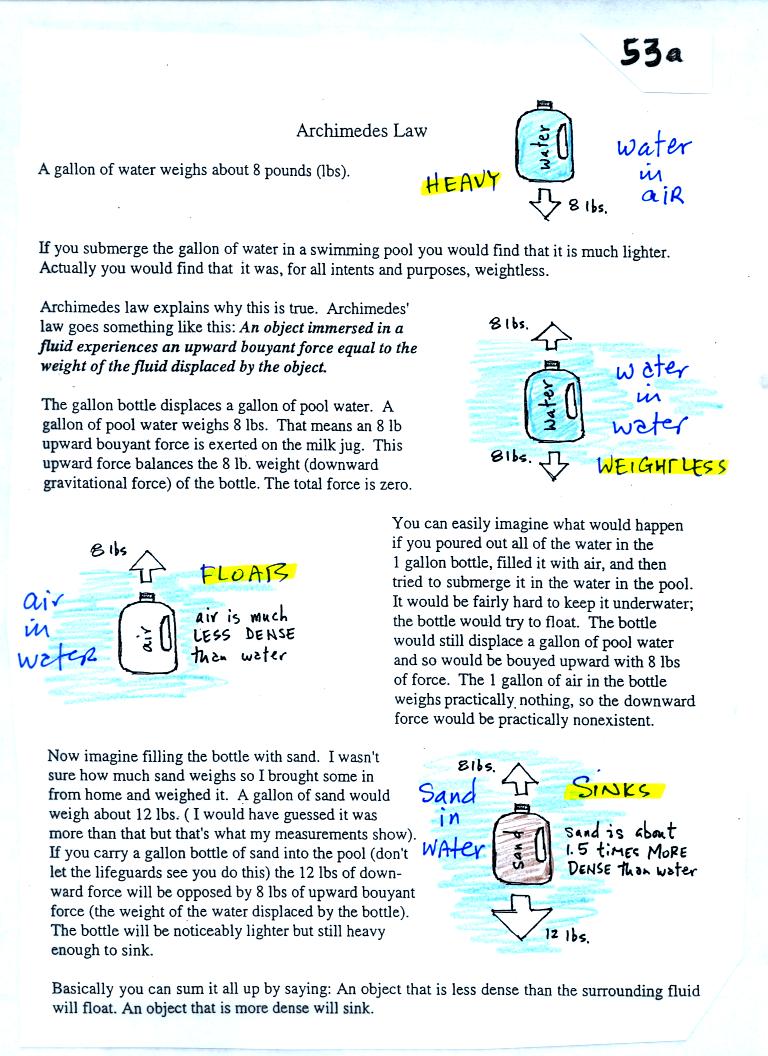
You might have a look at the material on Archimedes' Law on pps 53a and
53b in the photocopied Class Notes. That explains this same
material in a slightly different, perhaps clearer, way.


Next
learned a little bit about upper level charts. These maps show
conditions at various altitudes above the ground. Conditions up
there are important because they can strongly influence conditions at
the ground. Many of the
figures below differ somewhat from those used in class.
The figures below have hopefully been drawn more carefully and clearly.
At this point there are three basic things to know about upper level
charts. First the overall appearance is somewhat different from a
surface weather map. On a surface map you generally find circular
(more or less) centers of high and low pressure. You can also
find closed high and low pressure centers at upper levels, but more
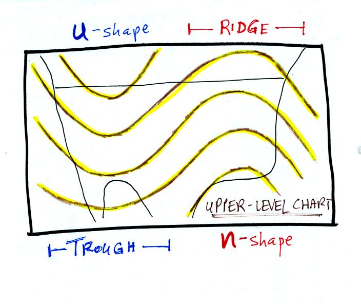
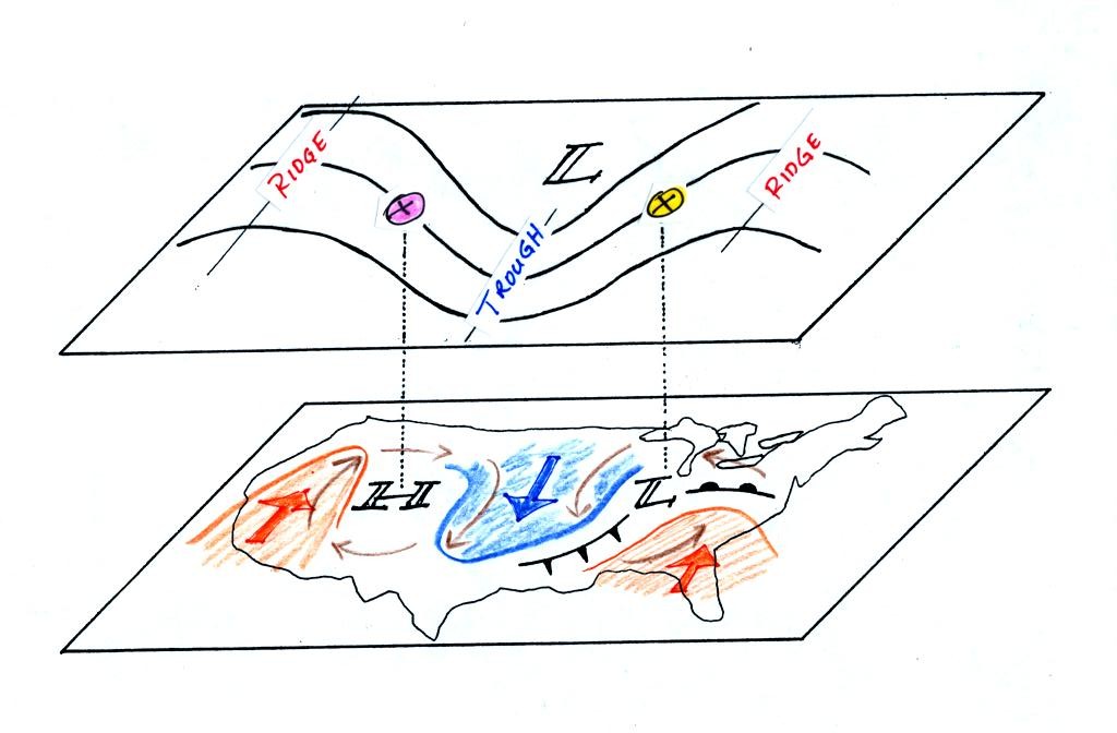
generally you find a wavy pattern like sketched below.

The U-shaped portion of the pattern is called a
trough. The
n-shaped portion is called a ridge.

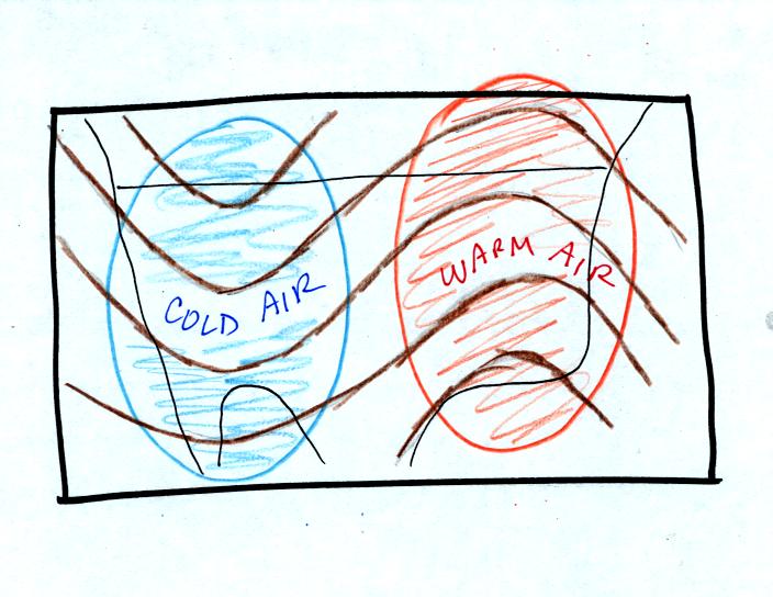
Troughs are produced by large volumes of cool or cold
air. The
western half of the country in the map above would probably be
experiencing colder than average temperatures. Large volumes of
warm or hot air produce ridges.

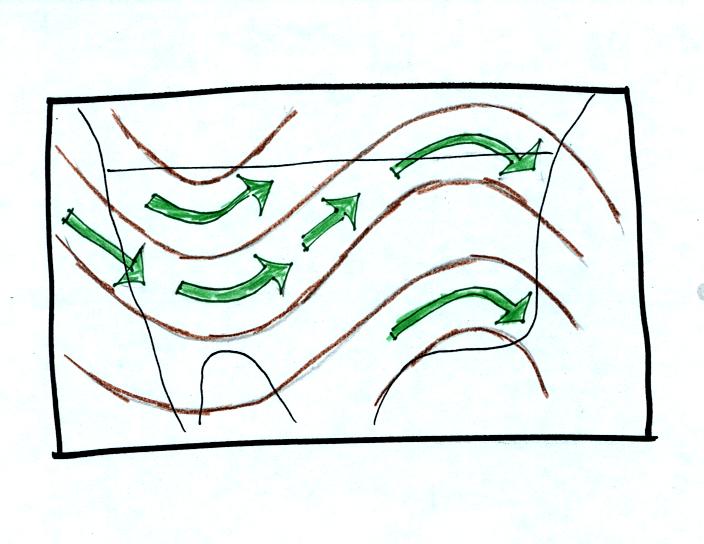
The winds on upper level charts blow parallel to the contour
lines. On a surface map the winds cross the isobars slightly,
spiralling into centers of low pressure and outward away from centers
of high pressure. The winds generally blow from west to east.
Next we will look at some of the interactions between features on
surface and upper level charts

On the surface map you see centers of HIGH and LOW
pressure.
The low pressure center, together with the cold and warm fronts, is a
middle latitude storm.
Note how the counterclockwise winds spinning around the LOW
move warm
air northward (behind the warm front on the eastern side of the LOW)
and cold air southward (behind the cold front on the western side of
the LOW). Clockwise winds spinning around the HIGH also move warm
and cold air. The winds are shown with thin brown arrows on the
surface map.
Note the ridge and trough features on the upper level
chart. We
learned that warm air is found below an upper level ridge. Now
you can begin to see the source of this warm air. Warm air is
found west of the HIGH and to the east of the LOW. This is
where the two ridges on the upper level chart are also found. You
expect to find cold air below an upper level trough. This cold
air is being moved into the middle of the US by the northerly winds
that are found between the HIGH and the LOW.
Note the yellow X marked on the upper level chart directly
above the
surface LOW. This is a good location for a surface LOW to develop
and strengthen (the surface low pressure will get even lower) We
will find that this is frequently a location
where there is upper level divergence. Similary the pink X is
where you often find upper level convergence. This could
cause surface high pressure to get even higher.
Now we
need to look in a little more detail at how upper level winds can
affect the development or intensification of a surface storm.

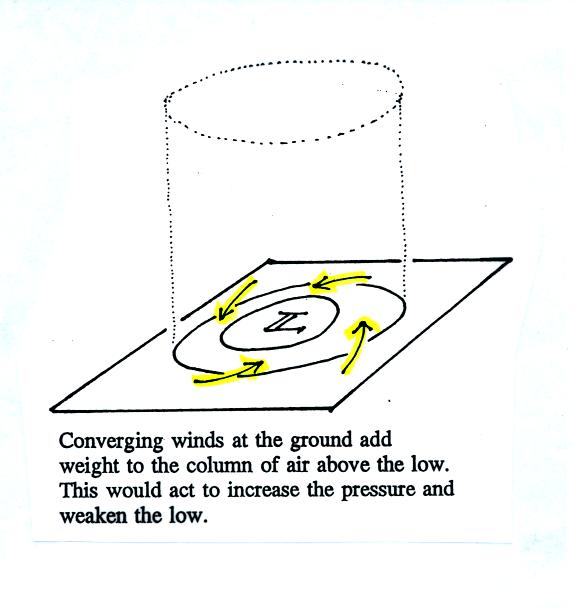
The surface winds are spinning counterclockwise and
spiralling in
toward the center of the surface low in the figure above (see p. 42 in
the photocopied Class Notes). This adds air to the cylinder of
atmosphere. Adding air to the cylinder means the cylinder will
weigh more and you would expect the surface pressure (which is
determined by the weight of the air overhead) to increase.
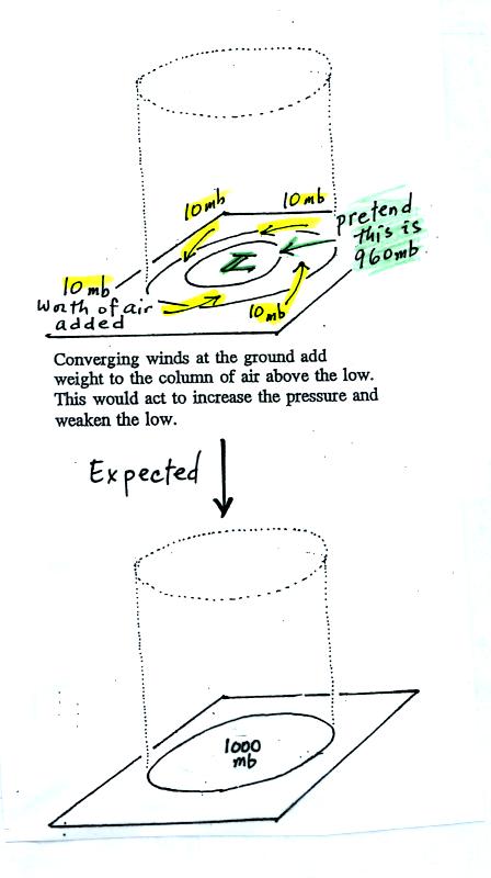
We'll just make up some numbers, this might make this clearer.

You'll find this figure on p. 42a in the Class Notes.
At the top we will assume the
surface low has 960 mb
pressure.
Imagine that each of the surface wind arrows winds brings in enough air
to increase the pressure
at the center of the LOW by 10 mb. You would expect the pressure
at the center of the LOW to increase from 960 mb to 1000 mb.
This is just like a bank account. You have $960 in the bank and
make four $10 dollar deposits. You would expect your bank account
balance to increase from $960 to $1000.
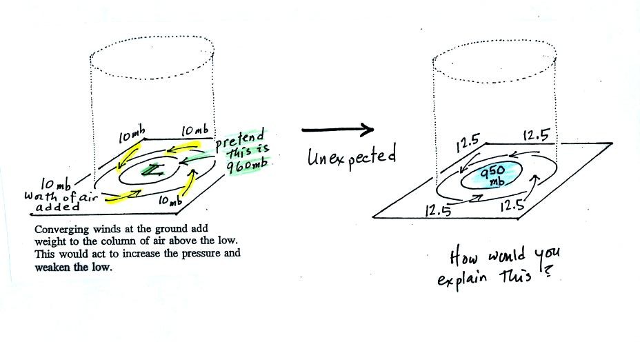
But what if the surface pressure decreased from 960 mb to 950 mb as
shown in the following figure?

The next figure shows us what could be happening (back to p.
42 in the Class Notes).

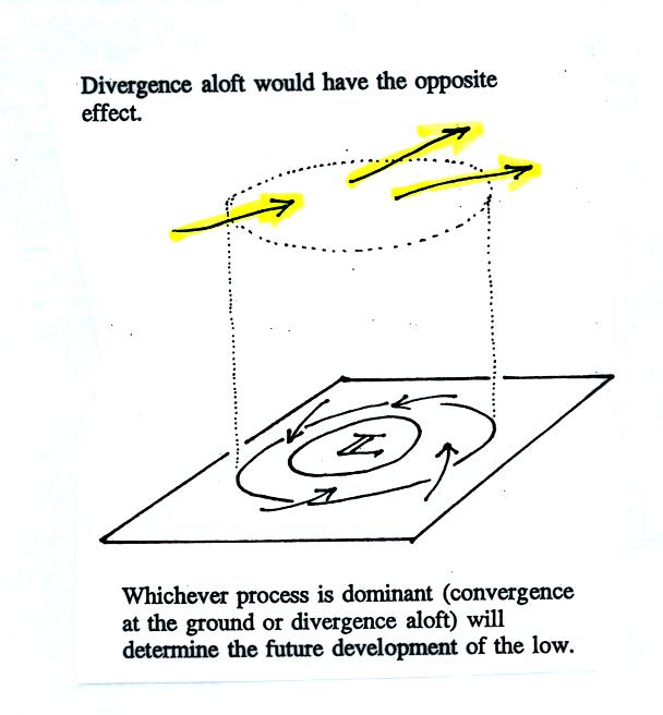
There may be some upper level divergence (more arrows
leaving the
cylinder than going in ). Upper level divergence removes air from
the cylinder and would decrease the weight of the cylinder.
We need to determine which of the two (converging winds at the surface
vs divergence at upper levels) is dominant. That will determine
what happens to the surface pressure.
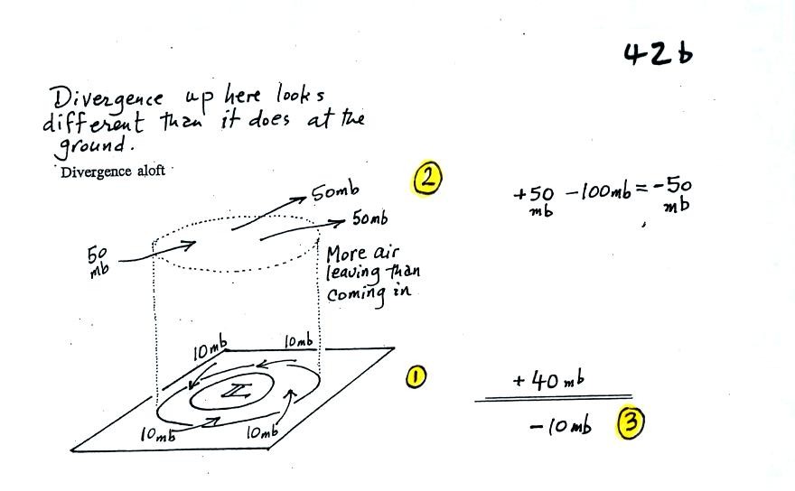
Again some actual numbers might help (see p. 42b in the Class Notes)

The 40 millibars worth of surface convergence is shown at
Point
1. Up at Point 2 there are 50 mb of air entering the cylinder but
100 mb leaving. That is a net loss of 50 mb. At Point 3 we
see the overall result, a net loss of 10 mb. The surface pressure
should decrease from 960 mb to 950 mb. That change is reflected
in the next picture (found at the bottom of p. 42b in the Class Notes).

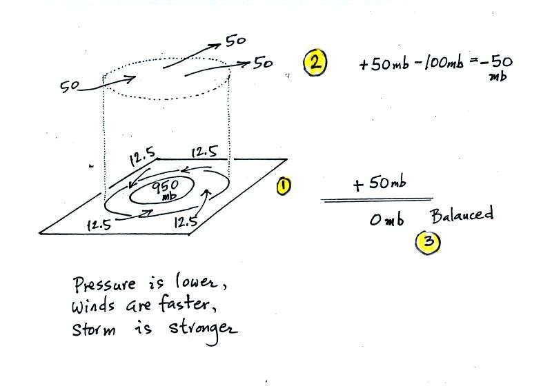
The surface pressure is 950 mb. This means there is
more of a
pressure difference between the low pressure in the center of the storm
and the pressure surrounding the storm. The surface storm has
intensified and the surface winds will blow faster and carry more air
into the cylinder (the surface wind arrows each now carry 12.5 mb of
air instead of 10 mb). The converging surface winds add 50 mb of
air to the cylinder (Point 1), the upper level divergence removes 50 mb
of air from the cylinder (Point 2). Convergence and divergence
are in balance (Point 3). The storm won't intensify any further.
Click here for some
additional
examples. By working through some additional examples you might
increase your understanding of this material and build up your
confidence (of course there's always a chance that more examples will
just make this topic more confusing - the choice is yours)
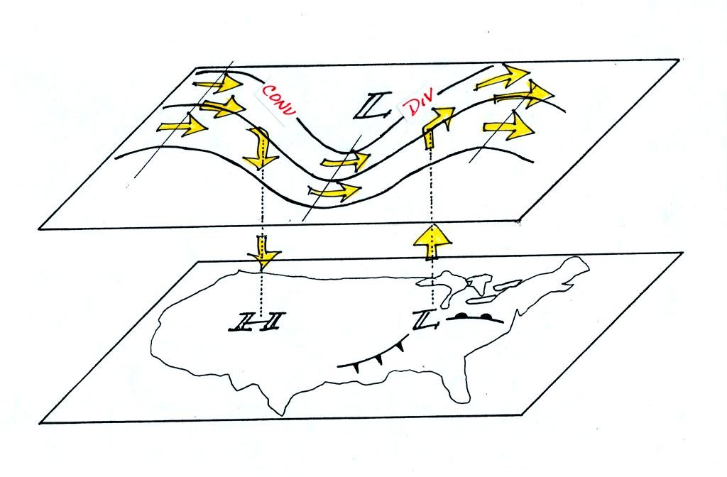
We're
almost done, one last figure (it's the figure on p. 41 in the
photocopied Class Notes again with some new information added (redrawn
here for improved clarity)

Now that you
have some idea of what upper level divergence looks like
you are in a position to understand another one of the relationships
between the surface and upper level winds.
One of the things we have learned about surface LOW pressure is that
the converging surface winds create rising air motions. The
figure above gives you an idea of what can happen to this rising air
(it has to go somewhere). Note the upper level divergence in the
figure: two arrows of air coming into the point "DIV" and three arrows
of air leaving (more air going out than coming in is what makes this
divergence). The rising air can, in effect, supply the extra
arrow's worth of air.
Three arrows of air come into the point marked "CONV" on the upper
level chart and two leave (more air coming in than going out).
What happens to
the extra arrow? It sinks, it is the source of the sinking air
found above surface high pressure.
We spent
the last few minutes of class watching another short segment of video
featuring Auguste and Jacques Piccard. In this video they
descended to a depth of 10,000 feet in the ocean in a bathyscaph.
