Monday Nov. 10, 2008
click here to download today's notes in
Microsoft WORD format.
The Expt. #3 reports have been graded and were returned in class
today. Revised reports are due in 2 weeks, on or before Mon.,
Nov. 24. Please return your original report with your revised
report.
Unless noted otherwise, the Expt. #4
reports were due today. It usually takes about 1 week to grade
those reports.
There was an Optional
Assignment hidden in the Friday Nov. 7 notes. You can still
earn half credit if you turn it in on Wed.
I'm afraid that the Lottery ticket I bought over the weekend wasn't a
winner. So funding is still in doubt for the end of the semester,
5-night all- expenses paid trip to Paris for two, grand prize.
1S1P Assignment #3 is now online. You
can do a maximum of 2 reports. Reports are due on or before Mon.,
Nov. 24.
We looked at how and why surface and upper level winds blow around
circular centers of high and low pressure in class last Friday.
Some real world examples of where this occurs are shown in the figure
below. The two largest types of storm systems, middle latitude
storms and hurricanes, develop around surface low pressure. Winds
spin counterclockwise around low in the northern hemisphere and
clockwise in the southern hemisphere. Winds spin clockwise around
"anticyclones" (high pressure) in the northern hemisphere and
counterclockwise in the southern hemisphere.
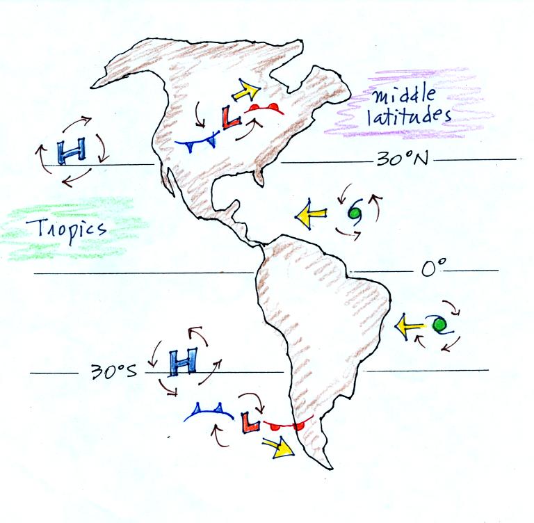
Storm systems in the tropics generally move from east to west. At
middle latitudes, storm move in the other direction, from west to
east. To understand why this is true we need to learn something
about the earth's global scale pressure and wind patterns. This
is a topic we will be getting into on Wednesday.
Spinning winds change directions in the northern and southern
hemispheres because of the Coriolis force. We learned rules for
the direction and strength of the Coriolis force last Friday, but
didn't really learn anything about what causes it. We spent a
little time in class today doing that. Most of what follows can
be found on p. 122c in the photocopied ClassNotes.
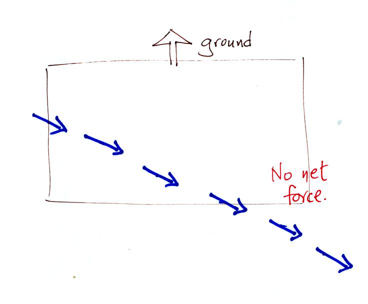
Imagine something flies over Tucson. It
travels
straight from west to east at constant speed. The next figure
shows the path that
the object followed as it passed over the city. More or less
subconciously you would plot its path relative to reference points on
the ground.
It would appear to be moving in a straight line at constant
speed. You would conclude there was zero net force acting on the
moving object (Newton's first law of motion).
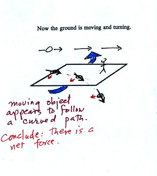
In this second picture the object flies by overhead
just as it
did in the previous picture. In this picture, however, the ground
is moving (don't worry about what might be causing the ground to move).
This is the path that you would see relative to the ground
in this
case. Even though the object flew from west to east it
appears to have been traveling from the NW toward the SE because the
ground was moving as the object passed overhead. Because
the motion is still in a straight line at constant speed, you would
conclude the net force acting on the object was zero.
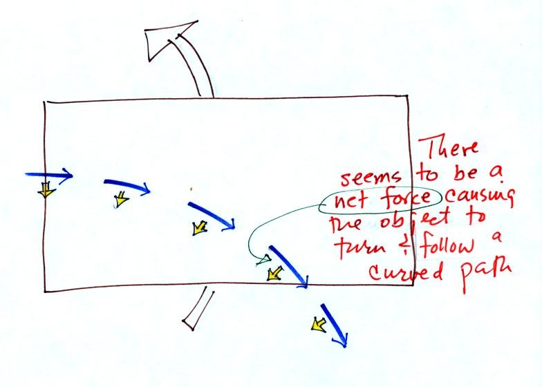
In this last figure the object flies by again from
west to
east. In this case however the ground is rotating.
At most locations on the earth the ground IS rotating (we're just not
aware of it). This is
most easily seen at the poles.
Imagine a piece of paper glued to the top of a globe.
As the
globe spins the piece of paper will rotate. A piece of paper
glued to the globe at the equator won't spin, it will flip over.
At points in between the paper would spin and flip, the motion gets
complicated.
The easiest thing for us to do is to ignore the fact that the ground on
which we are standing is rotating. However, if we do that we need
to account for the curved paths that moving objects will take when they
move relative to the earth's surface. That is what the Coriolis
force does.
You might already have heard that water spins in a different direction
when it drains from a sink or a toilet bowl in the southern hemisphere
than it does in the northern hemisphere. You might also have
heard that this is due to the Coriolis force or the Coriolis
effect.
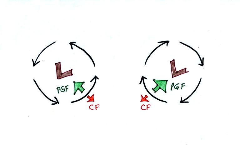
The Coriolis force does
cause winds to spin in opposite directions around high and low pressure
centers in the northern and southern hemisphere. The
PGF starts the air moving (in toward low, out and
away from high pressure) then the Coriolis force bends the wind to the
right (N. hemisphere) or to the left (S. hemisphere).
Here's what you end up with in the case of low pressure:
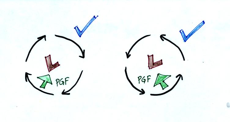
Wind motions around an upper level low. The
example at left would be found in the northern (the CF is pointing to
the right of the wind)? The PGF is stronger than the CF. This
results in a new inward force, something that is needed for wind to
blow in a circular path.
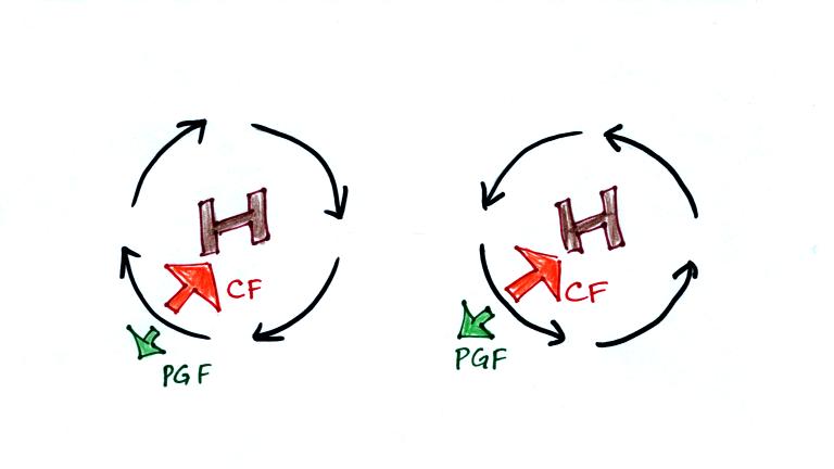
Winds also spin around high
pressure. The CF is absolutely essential in this case. The
CF is stronger than the PGF and the CF points
inward. The CF is what provides the needed inward force needed to
keep the winds blowing in a circular path.
There are situations where the PGF is much stronger than the CF; the CF
can be ignored.
Winds can still spin around LOW. The
PGF supplies the
necessary net inward force.
This is the case with
tornadoes, for example. Tornado winds spin around a core of very
low pressure.
Winds can't blow around high pressure without the
CF. The PGF points ouward with high
pressure. Without the CF,
there isn't any inward force.
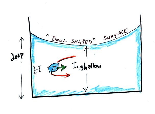
When water spins and drains from a sink or a toilet,
the water is a little deeper on the outside than on the inside.
This creates an inward pointing pressure difference force. There
needs to be an inward force in order for the water to spin. Water
can spin clockwise or counterclockwise when draining from a sink in the
northern hemisphere. It can spin in either direction in the
southern hemisphere also.
Now we watched a short video segment that seemed to show
otherwise. Don't believe everything you see on video. The
gentleman in the video was just very good at getting the draining water
to spin one direction or another as he moved on opposite sides of the
equator. Probably the most difficult part would be to get the
water draining without spinning, which is what he was able to do when
standing right on the equator.
Would you like to earn 0.1 pts of
extra credit? If so click here.
Next
we moved to a new topic, thermal circulations.
Differences
in temperature like you might find between a coast and
the ocean or between a city and the surrounding country side can create
horizontal pressure differences. The horizontal pressure gradient can
then produce a wind flow pattern known as a thermal circulation.
These are generally relatively small scale circulations and the
pressure gradient is so much stronger than the Coriolis force that the
Coriolis force can be ignored. We will learn how thermal
circulations develop and then apply to concept to the earth as a
whole
in order to understand large global scale pressure and wind
patterns. You'll find the
following discussion on p. 131 in the photocopied Class Notes.
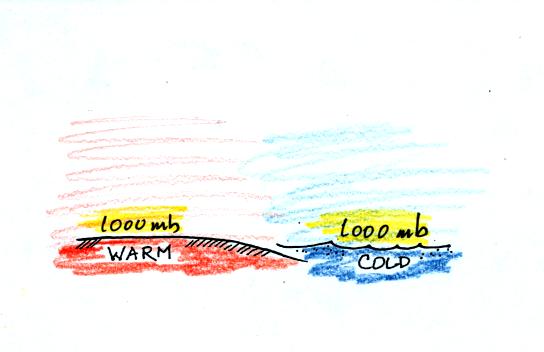
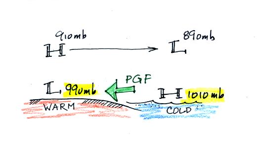
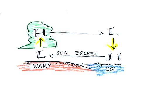
Even when the sea level pressures are the
same over the land and water (1000 mb above) an upper level pressure
gradient can be created. The upper level pressure
gradient force will
cause upper level winds to
blow from H (910 mb) toward L (890 mb).
The movement of air above the ground can affect the
surface
pressures. As air above the ground begins to move from left to
right, the surface pressure at left will decrease (from 1000 mb to 990
mb
in the picture below). Adding air at right will increase the
surface pressure there (from 1000 to 1010 mb).
This creates a
surface
pressure gradient.
The surface winds blow from high to low. The
surface
winds and
upper level winds are blowing in opposite directions.
You can complete the circulation loop by adding rising air above the
surface low pressure at left and sinking air above the surface high at
right. The surface winds which blow from the ocean onto land are
called a sea breeze (the name tells you where the winds come
from). Since this air is likely to be moist, cloud formation is
likely when the air rises over the warm ground.
At night the ground cools more quickly than the ocean and becomes
colder than the water. The thermal circulation pattern reverses
direction. Surface winds blow from the land out over the
ocean. This is referred to as a land breeze.