Wednesday Oct. 29, 2008
click here to download today's notes in
a more printer friendly Microsoft WORD format
El Cuarto de Tula
was the name of the song played before class today. It was from
the Buena Vista Social Club.
Answers to the Humidity Optional Assignment were handed out
today. The assignments themselves will be returned on Friday.
The Quiz #3 Study Pt. 1 and Pt. 2 are now available online.
The 3rd and final part should appear later this week.
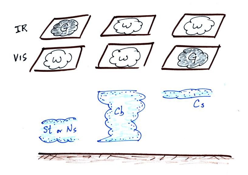
Naming and identifying clouds was covered in class on
Monday. This is a logical time to learn a little bit about the 2
most common types of satellite photographs. You'll find this
discussed on pps 99-100 in the photocopied ClassNotes. The
figures below were on a handout distributed in class.
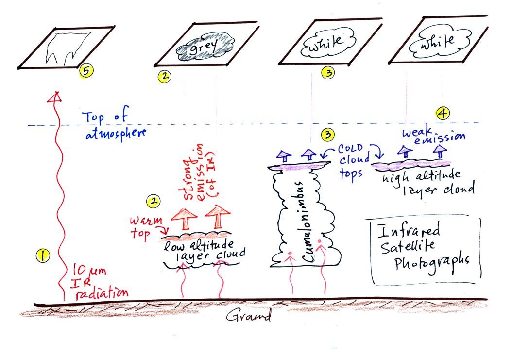
1. An infrared satellite photograph detects the 10 um IR
radiation
actually
emitted by the ground, the ocean and by clouds. You don't depend
on seeing
reflected
sunlight, so clouds can be photographed during the day and at
night. You may recall that 10 um radiation is in the middle of
the atmospheric window, so this radiation is able to pass through air
without being absorbed.
2. Clouds absorb 10 um radiation and then reemit
IR radiation. The top surface of a low altitude cloud will be
relatively warm. Warmer objects emit IR radiation at a greater
rate or at higher intensity (the Stefan Boltzmann law).
This is shown as grey on an IR satellite photograph. A
grey unimpressive looking cloud on an IR
satellite photograph may actually be a thick nimbostratus cloud that is
producing a lot of rain or snow.
3. Cloud tops found at high altitude are cold and emit IR
radiation at a lower rate or at lower intensity. This shows up
white on an IR photograph.
4. Two very different clouds (a thunderstorm and a
cirrostratus cloud) would both appear white on the satellite photograph
and would be difficult to distinquish. Meteorologists are
interested in locating tall thunderstorms as they can produce severe
weather.
5. The ground changes temperature during the course of the
day. On an infrared satellite animation you can watch the ground
change from black (afternoon when
the ground is warmest) to grey (early morning when the ground is cold)
during the course of a day. The ocean right alongside doesn't
change temperature much during the day and remains grey throughout the
day. Here's a link
to an IR satellite photograph loop on the UA Atmospheric Sciences Dept.
webpage.


Here's a summary of what we have
learned so far.
The figure below shows
how
if you combine both visible and IR
photographs you can begin to distinquish between different types of
clouds.

The last big topic we will cover
before next week's quiz is precipitation formation and types of
precipitation. Only two of the 10 main cloud types (nimbostratus
and cumulonimbus) are able to produce significant amounts of
precipitation.
This figure shows typical sizes of cloud
condensation nuclei (CCN), cloud droplets, and raindrops (a human hair
is about 50 um thick for comparison). As we
saw in the cloud in a bottle demonstration it is relatively easy to
make cloud droplets. You cool moist air to the dew point and
raise the RH to 100%. Water vapor
condenses pretty much instantaneously onto a cloud condensation nucleus
to form a cloud droplet. It
would take much longer (a day or more) for condensation to turn a cloud
droplet
into a
raindrop. You know from personal experience that once a cloud
forms you don't have to wait that long for precipitation to begin to
fall.
Part of the problem is that it takes quite a few 20 um
diameter cloud
droplets to make one 2000 um diameter raindrop. How many
exactly? Before answering that question we will look at a cube
(rather than a sphere).
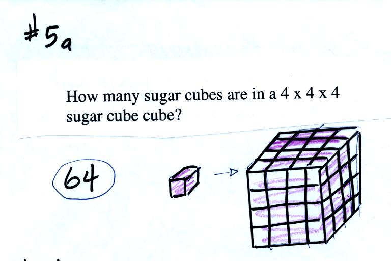
It would take 64 individual sugar
cubes to make a 4 cube x 4 cube x 4 cube cube. That is because
the bigger cube is 4 times wider, 4 times deeper, and 4 times
taller. Volume is 3 dimensions.

The raindrop is 100 times wider, 100 times
deeper, and 100 times taller than the cloud droplet. The raindrop
has a volume that is 100 x 100 x 100 = 1,000,000 (one million) times
larger than the volume of
the cloud droplets.
Fortunately there are two processes capable of quickly
turning small cloud droplets
into much larger precipitation particles in a cloud.

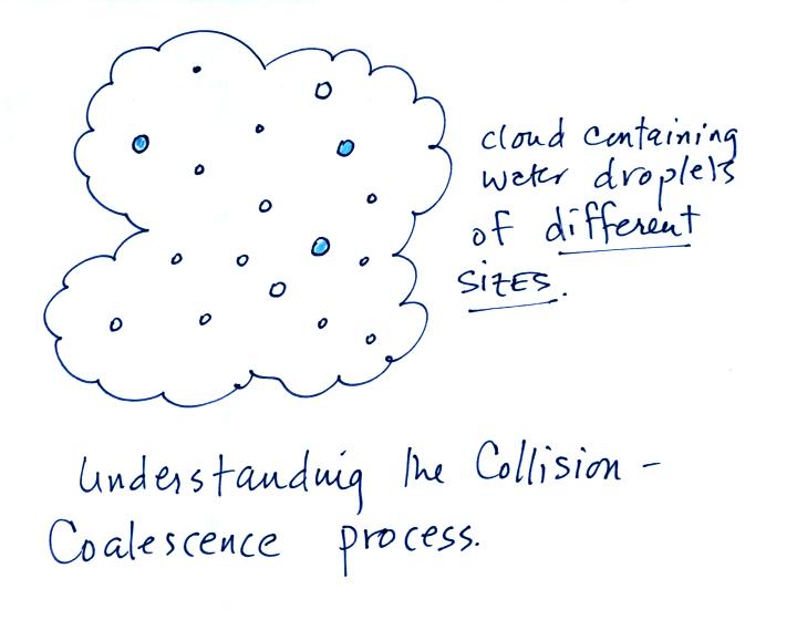
The collision coalescence process
works in clouds that
are
composed of water droplets only. Clouds like this are only found
in
the tropics. We'll see that this is a pretty easy process to
understand. This process will only produce rain.
The ice crystal process produces precipitation everywhere
else.
This is the process that makes rain in
Tucson, even on the hottest day in the summer. There is one part
of this process that is a little harder to understand. This
process can produce a variety of different kinds of precipitation
particles (rain, snow, hail, etc).
The following figures weren't covered in class on Wednesday.
We'll cover this quickly at the beginning of class on Friday.
Here's
what you might see if you looked inside a warm cloud with just water
droplets:
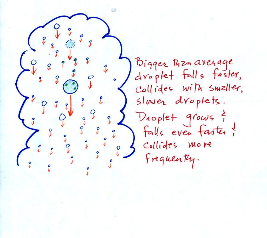
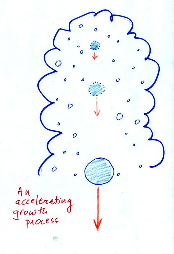
The collision coalescence process works best in a cloud
filled with cloud droplets of different sizes. A short video
shows that the larger droplets fall
faster than the small droplets. A larger than average cloud
droplet will overtake and collide with smaller slower moving
ones.
This is an acclerating growth process.
The
falling droplet
gets
wider, falls faster, and sweeps out an increasingly larger volume
inside the cloud. The bigger the droplet gets the faster it
starts to grow.