Here's a still photograph of heavy
localized rain falling from a thunderstorm. This might easily
have produced a microburst and strong surface winds.
Here's a quick review of the 3
stage life cycle of an ordinary air mass
thunderstorm.

Once the downdraft forms in the
middle (mature) stage, it begins
to spread horizontally in the interior of the cloud. The
downdraft eventually chokes off the updraft and the storm begins to
weaken and dissipate.
Under certain conditions the thunderstorm will move and the
updraft
will tilt. This is shown in the following figure.
Severe storms are more likely to
form when there is vertical wind
shear. Wind shear (pt 1) is changing wind direction or wind speed
with distance. In this case, the wind speed is increasing with
increasing altitude, that is vertical wind shear.
The thunderstorm itself will move in this kind of an environmen,
at an
average of the speeds at the top and bottom of the cloud (pt. 2).
The thunderstorm will move to the right more
rapidly than the air at the ground which is where the updraft
begins. Rising air that is situated at the front bottom edge
of the thunderstorm will find itself at the back edge of the storm when
it reaches the top of the cloud. This produces a tilted
updraft (pt. 3). The downdraft is situated at the back of the
ground. The updraft is continually moving to the right and
staying away from the downdraft. The updraft and downdraft
coexist and do not "get in each others way."
Sometimes the tilted updraft will begin to
rotate. A rotating updraft is called a mesocyclone (pt. 4).
Meso refers to medium size (thunderstorm size) and cyclone means winds
spinning around low pressure. Low
pressure in the core of the mesocyclone creates an inward pointing
pressure gradient force needed to keep the updraft
winds spinning in circular path (low pressure also keeps winds
spinning in a tornado). The cloud that extends below
the cloud base and surrounds the mesocyclone is called a wall
cloud (pt. 5). The largest and strongest tornadoes will generally
come
from the wall cloud.
Note (pt. 6) that a tilted updraft provides a way of keeping
growing
hailstones inside the cloud. Hailstones get carried up toward the
top of the cloud where they begin to fall. But they then fall
back into the strong core of the updraft and get carried back up toward
the top of the cloud.
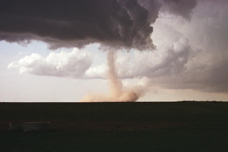
Here is a particularly nice photograph of a wall cloud and a
tornado. An even better photograph was in a book passed around in
class. The book was titled "Storm Chaser" and was written by
Warren Faidley, a local photographer.
Here is a relatively simple drawing
showing some of the key features on
a supercell thunderstorm. In a supercell the
rotating updraft (shown in orange above) is strong enough to penetrate
a short ways
into the stratosphere. This
produces the overshooting top or dome feature above. A wall cloud
and a tornado are shown at the bottom of the mesocyclone. In
an ordinary thunderstorm the updraft is unable to penetrate into the
very
stable air in the stratosphere and the upward moving air just
flattens out and forms an anvil. The
flanking line is a line of new cells trying to form alongside the
supercell thunderstorm.
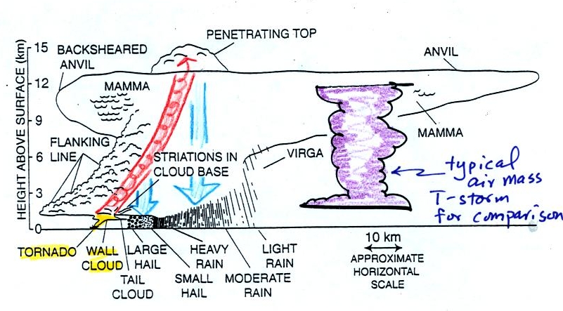
Here is a second slightly more
complicated drawing of a supercell
thunderstorm. A typical air mass thunderstorm (purple) has been
drawn in for comparison.
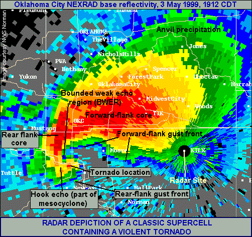
Supercell thunderstorms
also often produce a very distinctive signature on weather radar called
a "hook echo." We haven't covered weather radar in this class
this semester. But, in some respects a radar picture of a
thunderstorm is similar to an X-ray photograph of a human body.
X-rays are high energy
electromagnetic radiation that passes right through the flesh in a
human body (the fat, muscle etc.). Bone does absorb some of the
X-rays, however. So if you take an X-ray of a person you see only
part of what is inside their body, you see the skeleton.
A radar emits microwave
radiation. This radiation passes right through the cloud itself
but is reflected by the larger precipitation particles (rain, graupel,
etc). This reflected radiation is detected by the radar. A
radar image of a cloud is usually just a horizontal slice through the
cloud. In the picture above the radar would slice through the
middle of the cloud and would detect only the column of
precipitation. The intensity of the precipitation (determined by
the size and number of precipitation particles) is color coded on the
radar display (red would be heavy precipitation, green light
precipitation).
We watched a short video segment at this point. It showed a
photograph of a distant supercell thunderstorm with a distinctive
dome. The video showed the wall clouds at the bottoms of 2 or 3
other much closer supercells. And finally a computer
simulation of the air motions inside a
supercell thunderstorm was shown. Researchers understand the
development of a supercell pretty well. The exact process that
initiates tornado development is still unknown, however.
With all this talk of spinning
updrafts in thunderstorms, the next
logical topic is tornadoes.

The United States has more
tornadoes in an average year than
any
other country in the world (over 1000 per year). The
central US has just the right mix of
meteorological
conditions.
In the spring, cold dry
air can move all the way from
Canada (without being blocked by mountains) and collide with
warm moist air
from the Gulf of Mexico to form strong cold fronts and thunderstorms.
Tornadoes have
been observed in
every state in the US, but tornadoes are most frequent in the central
plains, a region referred to as "Tornado Alley" (highlighted in red,
orange, and yellow above). The map at right above can be found on
p. 161 in the photocopied ClassNotes.

Here are some basic
tornado characteristics (the
figure above is found on p.
161 in the photocopied class notes).
1. About 2/3rds of tornadoes
are F0 or F1 tornadoes (see below) and have spinning winds of
about 100 MPH or less. Microburst winds can also reach 100
MPH. They are a
lot more common in Tucson in the summer than tornadoes but can inflict
some of the same kinds of damage.
2. A very strong inwardly directed pressure
gradient force is needed to keep winds spinning in a circular
path. The
PGF is much stronger than the Coriolis Force (CF) and the CF can be
neglected.
The pressure in the center core of a tornado can be 100 mb less than
the pressure in the air outside the tornado. This is a very large
pressure difference in a short distance.
3. Tornadoes can spin clockwise or
counterclockwise, though
counterclockwise rotation is more common.
4, 5. Tornadoes usually last only a few minutes
and leave a path
on the ground that is a few miles
long. We will look at an exception below.
6, 7, 8. Most tornadoes
move from the SW toward the NE at a few 10s of MPH. Most
tornadoes have diameters of hundreds of feet, but tornadoes with
diameters over a mile have been observed.
9, 10. Tornadoes
are most
frequent in the Spring. The strongest tornadoes also occur at
that time of year. Tornadoes are most common in the late
afternoon when the atmosphere is most unstable.
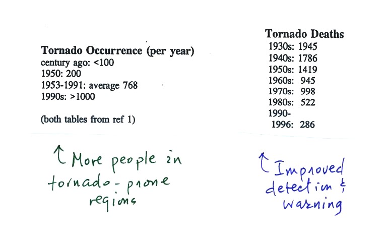
At the present time about 75 people
are killed
every year in the
United States. Lightning and flash floods (floods are the most
serious
severe weather hazard) kill slightly more people. Hurricanes kill
fewer people on average than tornadoes. Heat in the summer and
cold in the winter kill many more people than floods, tornadoes,
lightning, and hurricanes.
Most
tornadoes last only a few minutes and leave a path a few miles long on
the ground. There are of course exceptions. One is
discussed below.
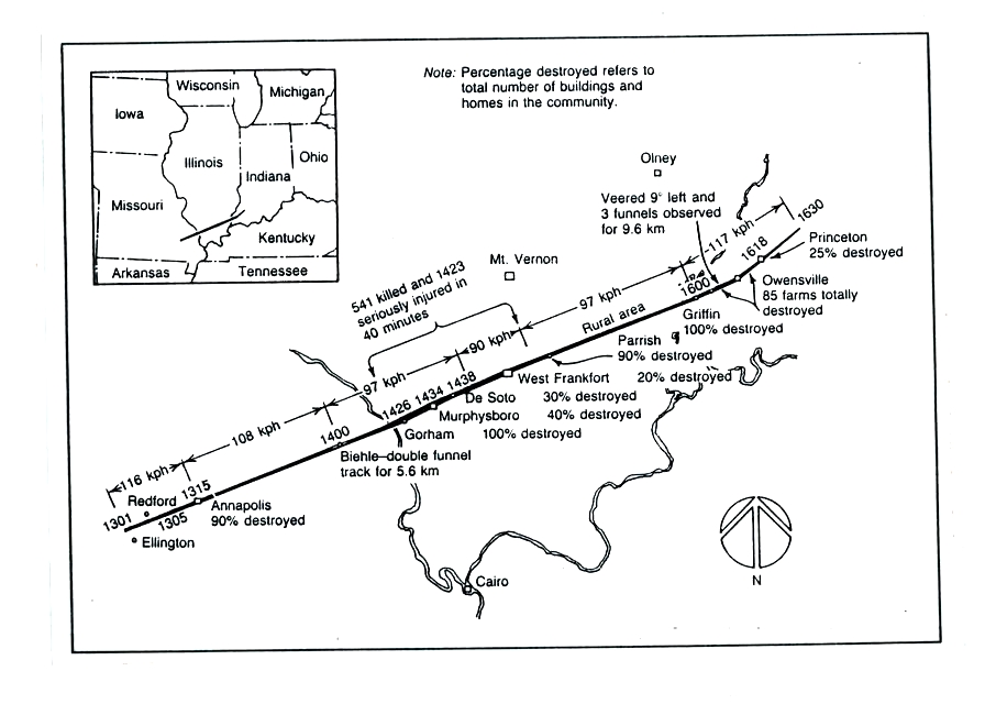
The path of the 1925 "Tri-State
Tornado" is shown
above. The
tornado path (note the SW to NE orientation) was 219 miles long, the
tornado last about 3.5 hours and
killed 695 people. The tornado was traveling over 60 MPH over
much of its path. It is the deadliest single tornado ever.
Tornadoes often occur in
"outbreaks."
The paths of 148
tornadoes
during the April 3-4, 1974 "Jumbo Tornado
Outbreak" are shown above. Note the first tornadoes were located
in the upper left corner of the map. The tornadoes were produced
by thunderstorms forming along a cold front. During this two day
period the front moved from the NW part toward the SE part of the
figure. Note that all the tornado paths have a SE toward NE
orientation.
Before
looking at another tornado video,
here's an easy
to remember version of the Fujita Scale used to rate tornado
intensity. Because it is so hard to make measurements of tornado
wind speeds, intensity estimates are usually based on an examination of
the damage caused by the tornado.
At this point another short
video with images of several different
tornadoes was shown. Descriptions of the tornadoes are given in
the table below.
54a
|
F3
|
Grand
Island, NE
|
Mar.
13,
1990
|
tornado
cloud is pretty
thick and vertical
|
61f
|
F3
|
McConnell
AFB KS
|
Apr.
26,
1991
|
this
is about as close to a
tornado as you're ever likely to get. Try to judge the diameter
of the tornado cloud. What direction are the tornado winds
spinning?
|
52
|
F5
|
Hesston
KS
|
Mar.
13,
1990
|
Watch
closely,
you may see a tree or two uprooted by the tornado winds
|
51
|
F3
|
North
Platte NE
|
Jun.
25,
1989
|
Trees
uprooted
and buildings lifted by the tornado winds
|
65
|
F1
|
Brainard
MN
|
Jul.
5,
1991
|
It's
a good
thing this was only an F1 tornado
|
57
|
F2
|
Darlington
IN
|
Jun.
1,
1990
|
Tornado
cloud
without much dust
|
62b
|
F2
|
Kansas
Turnpike
|
Apr.
26,
1991
|
It's
sometimes
hard to run away from a tornado. Watch closely you'll see a van
blown off the road and rolled by the tornado. The driver of the
van was killed!
|
47
|
F2
|
Minneapolis
MN
|
Jul.
18,
1986
|
Tornado
cloud
appears and disappears. |
The figure
below shows the steps in the formation, intensification, and weakening
of a tornado. This is sometimes referred to as the tornado life
cycle. Don't worry about learning the names of the various
stages. The idea is for you to be able to recognize an unusually
strong tornado if you ever see one in person or on video tape.
You might also be able to tell from a tornadoes appearance whether it
is near the beginning or end of its life cycle.
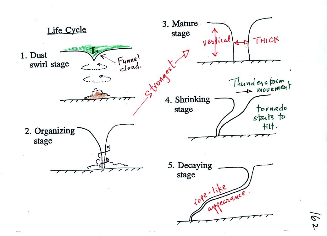
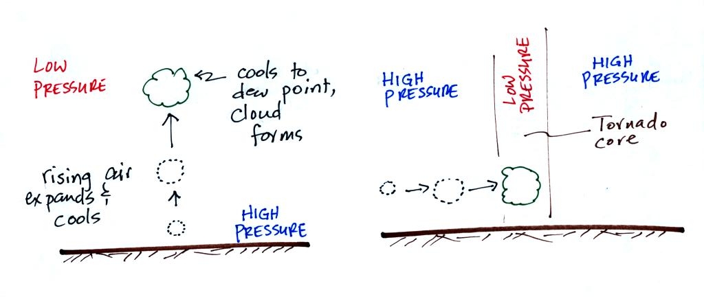
In Stage 2, moist air moves horizontally toward the low pressure in the
core of the tornado. This sideways moving air will expand and
cool just as rising air does (see figure below). Once the air
cools enough (to the
dew point temperature) a cloud will form.
Tornadoes can go from Stage 2 to Stage 3 (this is what the strongest
tornadoes do) or
directly from stage 2 to stage 5. Note a strong tornado is
usually vertical and thick as shown in Stage 3. "Wedge tornadoes"
actually appear wider than they are tall.
The thunderstorm and the top of the tornado will move faster than the
surface winds and the bottom of the tornado. This will tilt and
stretch the tornado. The rope like appearance in Stage 5 is
usually a sign of a weakening tornado.
At this point we watched another couple of video tapes. The first
illustrated
well the first 3 steps in the formation of a tornado (dust swirl stage
up to mature stage). The tornado was photographed near Luverne
Oklahoma in May 1991. It was eventually rated an F3 tornado.
The 2nd tape showed a tornado that
occurred in Pampa, Texas. Near the end of
the segment, video photography showed several vehicles (pick up trucks
and a van) that had been lifted 100 feet or so off the ground that were
being thrown around at 80 or 90 MPH by the tornado
winds. Winds speeds of about 250 MPH were estimated from the
video photography.