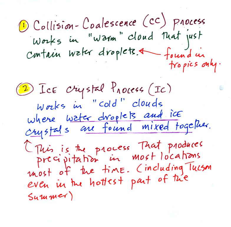
The collision coalescence process
works in clouds that
are
composed of water droplets only. Clouds like this are only found
in
the tropics. We'll see that this is a pretty easy process to
understand. This process will only produce rain.
The ice crystal process produces precipitation everywhere
else.
This is the process that makes rain in
Tucson, even on the hottest day in the summer. There is one part
of this process that is a little harder to understand. This
process can produce a variety of different kinds of precipitation
particles (rain, snow, hail, etc).
Here's
what you might see if you looked inside a warm cloud with just water
droplets:
The collision coalescence process works best in a cloud
filled with cloud droplets of different sizes. A short video
shows that the larger droplets fall
faster than the small droplets. A larger than average cloud
droplet will overtake and collide with smaller slower moving
ones.
This is an acclerating growth process.
The
falling droplet
gets
wider, falls faster, and sweeps out an increasingly larger volume
inside the cloud. The bigger the droplet gets the faster it
starts to grow.
The figure
below shows the two precipitation producing clouds:
nimbostratus (Ns) and cumulonimbus (Cb). Ns clouds are thinner
and have weaker updrafts than Cb clouds. The largest raindrops
fall from Cb clouds because the droplets spend more time in the cloud
growing. In a Cb cloud raindrops can grow while being carried upward by
the updraft and also when falling in the downdraft.
Raindrops grow up to about 1/4 inch in diameter.
When
drops get
larger than that, wind resistance flattens out the drop as it falls
toward the ground. The drop begins to "flop" around and breaks
apart
into several smaller droplets. Solid precipitation particles such
as hail can get much larger (an inch or two or three in diameter).
Before
learning about the second precipitation producing process, the ice
crystal process, we need to look at the structure of cold clouds.
The figure below is a redrawn version of what was drawn in class.

The bottom of the thunderstorm,
Point 1, is warm
enough
(warmer than freezing) to just
contain water
droplets. The top of the thunderstorm, Point 2, is colder than
-40 C and just contains ice crystals. The interesting part of the
thunderstorm and the
nimbostratus cloud is the middle part, Point 3, that contains both
supercooled water
droplets (water that has
been cooled to below freezing but hasn't frozen) and ice
crystals.
This is called the mixed phase
region. This is where the ice crystal process will be able
to produce
precipitation. This is also where the electrical charge that
results in lightning is generated.
The supercooled water droplets aren't able to freeze even though
they
have been cooled below freezing. At Point 4 we see this is
because it is much
easier for small droplets of water to freeze onto an ice crystal
nucleus or for water vapor to be deposited onto an ice crystal nucleus
(just like it is easier for water vapor to condense onto
condensation nuclei rather than condensing and forming a small droplet
of pure water). Not just any material will work as an ice nucleus
however. The material must have
a crystalline structure that is like that of ice. There just
aren't very many ice crystal nuclei in the atmosphere. It is hard
for water droplets to freeze unless they're really cold (colder than
-40 C)
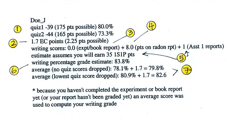
Here's an example of a grade summary.
1. These are your Quiz #1 and Quiz #2 scores and the percentage
grades. There is a small error in the Quiz #1 percentage grade:
it should be 77.7% instead of 80.0%. The error will be corrected
on the next grade summary.
2. The number of extra credit points (from the optional assignments)
that you have earned so far.
3. If you have completed an experiment report, the grade should appear
here. If not, then an average grade was used during the grade
estimate calculations to show the effect of the writing grade on your
overall average. Don't get the idea that you don't have to do any
experiment report, you do.
4. This is the grade you received on your Bonus 1S1P report on Radon.
5. Because some of the reports haven't been graded yet, none of the
1S1P Assignment #1 grades have been used in the grade summary.
Instead the computer "guessed" at how many 1S1P pts you will have at
the end of the semester. If you have turned in two Assignment #1
reports so far, the computer assumed you would continue writing reports
and would earn 45 pts by the end of the semester (45 is the maximum
number of 1S1P pts you can earn during the semester). If you only
turned in 1 report, the computer assumed you would end up with 35
pts. And if you haven't turned in any 1S1P reports, the computer
started to wonder about that and assumed you might have decided not to
write very many 1S1P reports.
It is important to understand that even if you haven't
written any 1S1P reports yet, there is still time to catch up and earn
45 pts (the maximum number of points allowed). But you need to
get started now. The next assignment is due next week and you
should plan on turning in two reports.
It is also important to realize that the number of 1S1P
pts you have been given by the computer for the purposes of this grade
estimate aren't real points. At the end of the semester the
computer will only use points that you have actually earned on reports
that you have turned in.
6. The writing score percentage grade is obtained by adding the
experiment report points (maximum of 40 pts) and the 1S1P pts (maximum
of 45 pts), dividing by 80, and multiplying the result by 100%.
7. This is the computer's guess at what you overall average
grade will be at the end of the semester if you keeping doing as you've
done so far. The average is based on quiz scores and your writing
percentage grade. The extra credit points have been added
in. The first average (no quiz grades dropped) is the one that
has to be 90.0 or above to get out of the final.
Please check your grade report and make sure the grades are
correct. If you have any questions then come and check with me.


