Fri., Oct. 30, 2009
click here to download today's notes in
a more printer friendly format
Keep an eye out for typos, the Friday afternoon notes are often
put together in a hurry.
Today's music was Hibernian
Rhapsody and was played by a group named De Dannan. It's a
Celtic version of Queen's Bohemian
Rhapsody .
This is a logical time to learn a little bit about the 2
most common types of satellite photographs. You'll find this
discussed on pps 99-100 in the photocopied ClassNotes. Throw
those old notes away, the figures below are better and were on a
handout distributed in class. You'll find some questions (in red) embedded
in the notes. These formed part of an in-class optional
assignment. You won't earn any extra credit if you did the
assignment, but you could earn a green card.
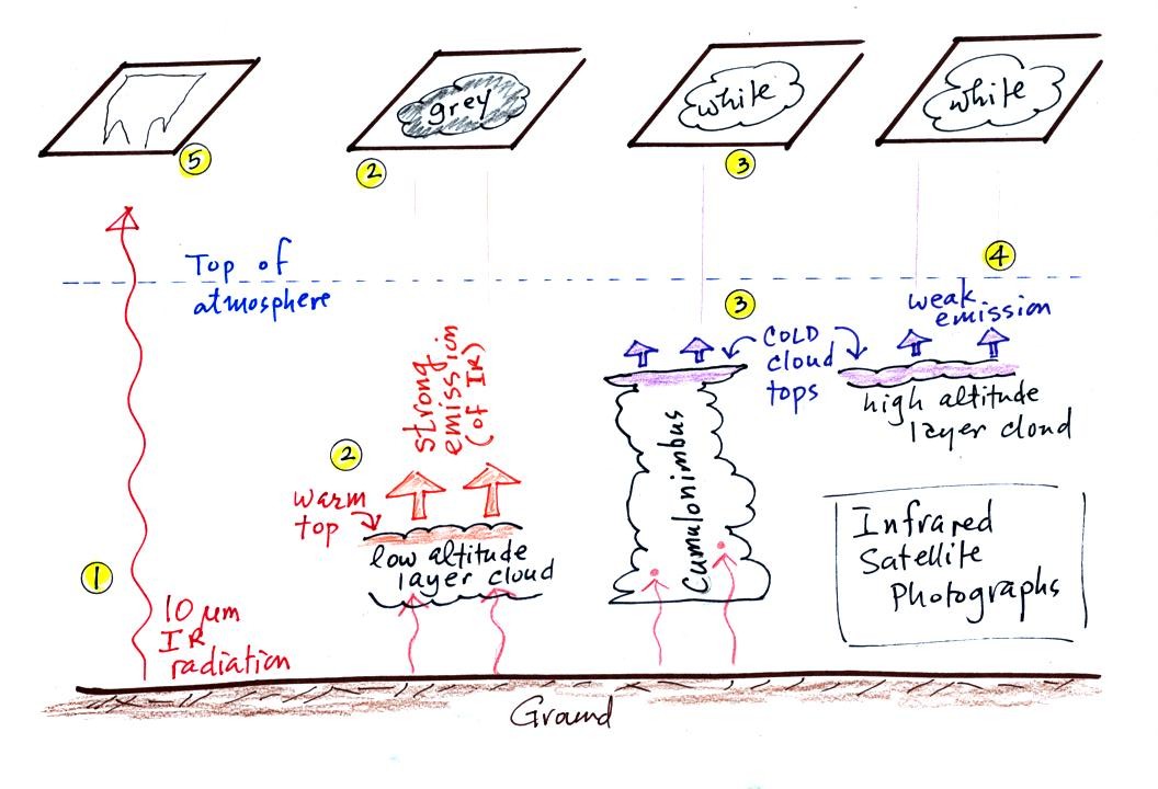
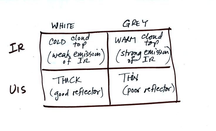
When you see satellite photographs
of clouds on the TV weather you are probably seeing an infrared
satellite photograph.
Question #1 -
Name the low altitude layer cloud and the high altitude layer cloud in
the figure above.
Question #2 - On an IR satellite photograph, the ground will often
change from dark grey or black to light gray during the day. The
ocean nearby won't change at all. Why does the ground change
color but not the ocean?
1. An infrared satellite photograph detects the 10 um IR
radiation
actually
emitted by the ground, the ocean and by clouds. You don't depend
on seeing
reflected
sunlight, so clouds
can be photographed during the day and at
night. You may recall that 10 um radiation is in the
middle of
the atmospheric window, so this radiation is able to pass through air
without being absorbed. If clouds don't get in the way, you can
see the ground on an IR photograph.
2. Clouds absorb 10 um radiation and then reemit
IR radiation. The top surface of a low altitude cloud will be
relatively warm. Warmer objects emit IR radiation at a greater
rate or at higher intensity (the Stefan Boltzmann law).
This is shown as grey on an IR satellite photograph. A
grey unimpressive looking cloud on an IR
satellite photograph may actually be a thick nimbostratus cloud that is
producing a lot of rain or snow.
3. Cloud tops found at high altitude are cold and emit
IR
radiation at a lower rate or lower intensity. This shows up
white on an IR photograph.
4. Two very different clouds (a thunderstorm and a
cirrostratus cloud) would both appear white on the satellite photograph
and would be difficult to distinquish. Meteorologists are
interested in locating tall thunderstorms because they can produce
severe
weather.
5. The ground changes temperature during the course of
the
day. On an infrared satellite animation you can watch the ground
change from dark grey or black (afternoon when
the ground is warmest) to lighter grey (early morning when the ground
is cold)
during the course of a day. Because of water's high specific
heat, the ocean right alongside doesn't
change temperature much during the day and remains grey throughout the
day. Here's a link
to an IR satellite photograph loop on the UA Atmospheric Sciences Dept.
webpage.
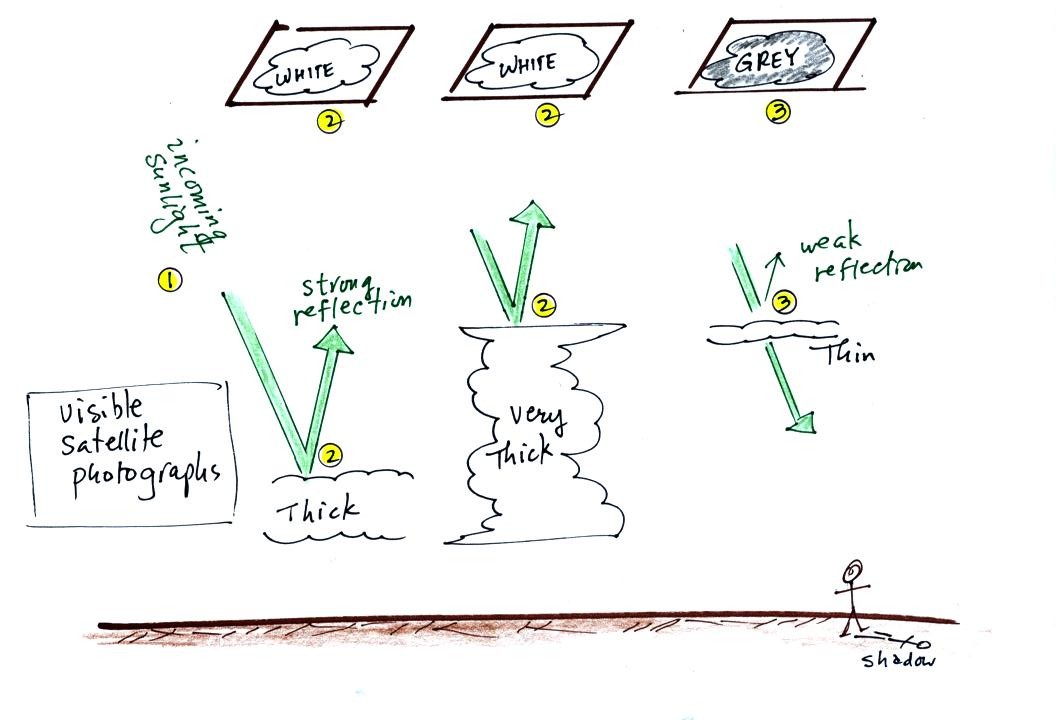
A visible satellite photograph
photographs sunlight that is
reflected
by clouds. You won't see much on a visible satellite photograph
at night. Thick clouds are good reflectors and appear
white. Thinner clouds don't reflect as much light and appear
grey. The low altitude layer cloud and the thunderstorm would
both appear white on this photograph and would be difficult to
distinquish.
Question #3 -
Why are high-altitude clouds thin?
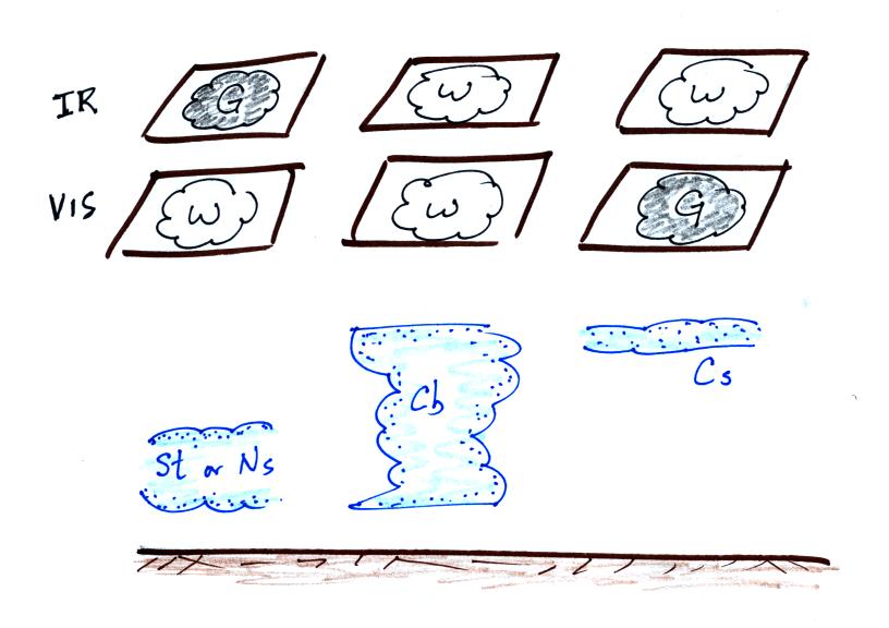
Here's a summary of what we have
learned so far. The figure
above wasn't shown in class.
The figure below shows
how
if you combine both visible and IR
photographs you can begin to distinquish between different types of
clouds.
The last
big topic we will cover
before next week's quiz is precipitation formation and types of
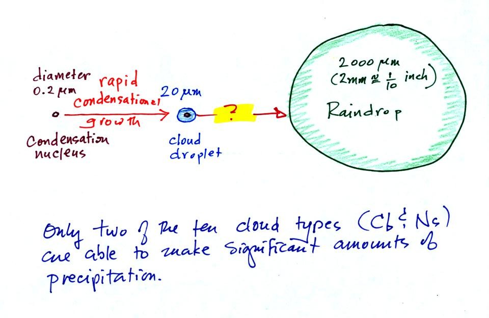
precipitation. Only two of the 10 main cloud types (Question #4 (I
think) - What 2 cloud types are they?) are able to produce
significant amounts of
precipitation.
This figure shows typical sizes of cloud
condensation nuclei (CCN), cloud droplets, and raindrops (a human hair
is about 50 um thick for comparison). As we
saw in the cloud in a bottle demonstration it is relatively easy to
make cloud droplets. You cool moist air to the dew point and
raise the RH to 100%. Water vapor
condenses pretty much instantaneously onto a cloud condensation nucleus
to form a cloud droplet. It
would take much longer (a day or more) for condensation to turn a cloud
droplet
into a
raindrop. You know from personal experience that once a cloud
forms you don't have to wait that long for precipitation to begin to
fall.
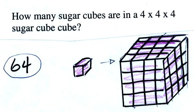
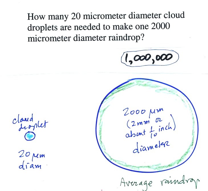
Part of the problem is that it takes quite a few 20 um
diameter cloud
droplets to make one 2000 um diameter raindrop. How many
exactly? Before answering that question we will look at a cube
(rather than a sphere).
It would take 64 individual sugar
cubes to make a 4 cube x 4 cube x 4 cube cube. That is because
the bigger cube is 4 times wider, 4 times deeper, and 4 times
taller. Volume is 3 dimensions.
The raindrop is 100 times wider, 100 times
deeper, and 100 times taller than the cloud droplet. The raindrop
has a volume that is 100 x 100 x 100 = 1,000,000 (one million) times
larger than the volume of
the cloud droplets.
Question #5 -
How many 20 um diameter cloud droplets would you need to make 1 200 um
diameter drop of drizzle?
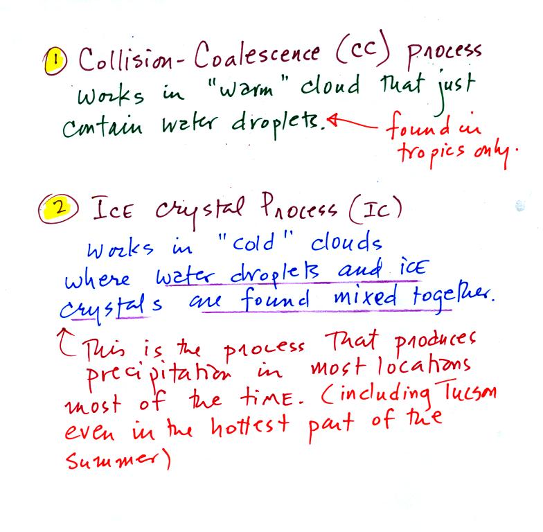
Fortunately there are two processes capable of quickly
turning small cloud droplets
into much larger precipitation particles in a cloud.
The collision coalescence process
works in clouds that
are
composed of water droplets only. Clouds like this are only found
in
the tropics. We'll see that this is a pretty easy process to
understand. This process will only produce rain, drizzle, and
something called virga.
The ice crystal process produces precipitation everywhere
else.
This is the process that makes rain in
Tucson, even on the hottest day in the summer (summer thunderstorm
clouds are tall and reach into cold parts of the atmosphere, well below
freezing. Hail or something resembling hail called graupel often
falls from these storms; proof that the precipitation started out as an
ice particle). There is one part
of this process that is a little harder to understand. This
process can produce a variety of different kinds of precipitation
particles (rain, snow, hail, sleet, graupel, etc).
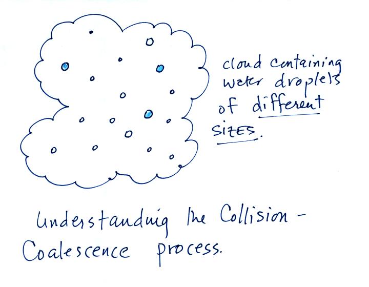
Here's
what you might see if you looked inside a warm cloud with just water
droplets:
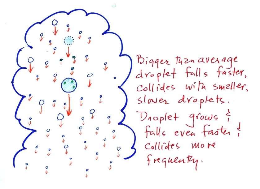
The collision coalescence process works best in a cloud
filled with cloud droplets of different sizes. A short video
showed that the larger droplets fall
faster than the small droplets. A larger than average cloud
droplet will overtake and collide with smaller slower moving
ones.
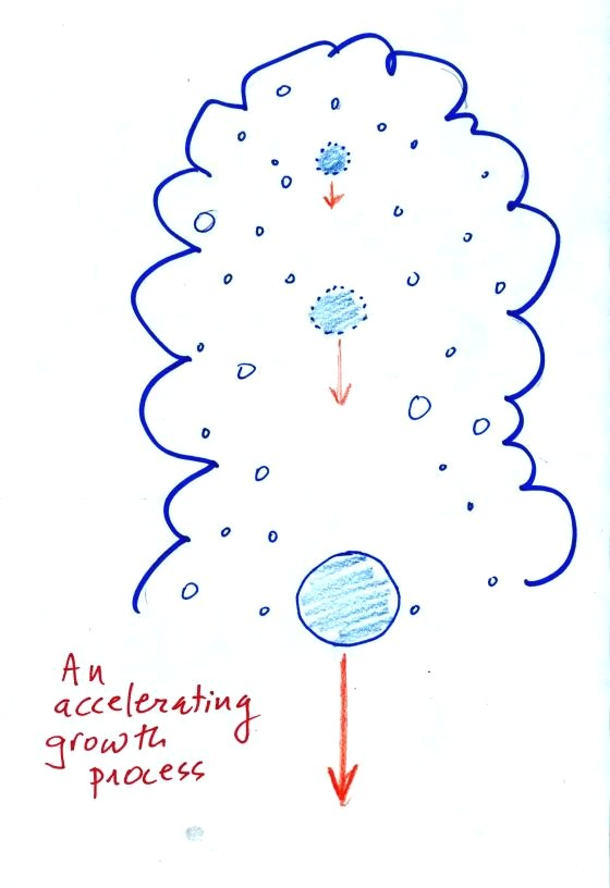
This is an acclerating growth process.
The
falling droplet
gets
wider, falls faster, and sweeps out an increasingly larger volume
inside the cloud. The bigger the droplet gets the faster it
starts to grow.
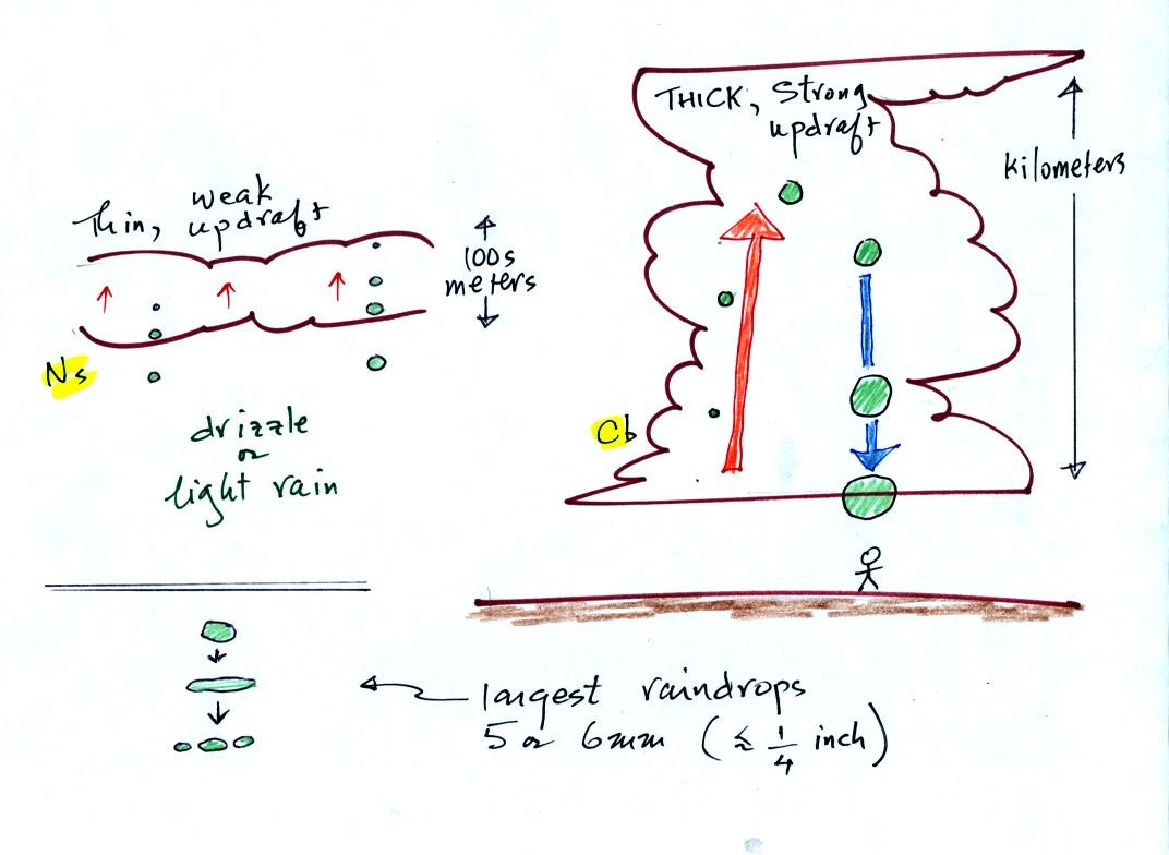
The figure
below shows the two precipitation producing clouds:
nimbostratus (Ns) and cumulonimbus (Cb). A little more carefully drawn
version than was done in class. Ns clouds are thinner
and have weaker updrafts than Cb clouds. The largest raindrops
fall from Cb clouds because the droplets spend more time in the cloud
growing. In a Cb cloud raindrops can grow while being carried upward by
the updraft and also when falling in the downdraft.
Raindrops grow up to about 1/4 inch in diameter.
When
drops get
larger than that, wind resistance flattens out the drop as it falls
toward the ground. The drop begins to "flop" around and breaks
apart
into several smaller droplets. Solid precipitation particles such
as hail can get much larger (an inch or two or three in diameter).