

Between
now and the end of the semester we will be covering Thunderstorms,
Tornadoes, Lightning, and Hurricanes. We just got started on
thunderstorms today. Here's a brief introduction.

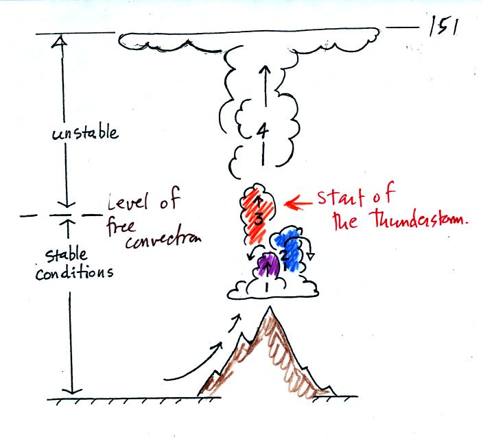
The top portion
of this figure summarizes
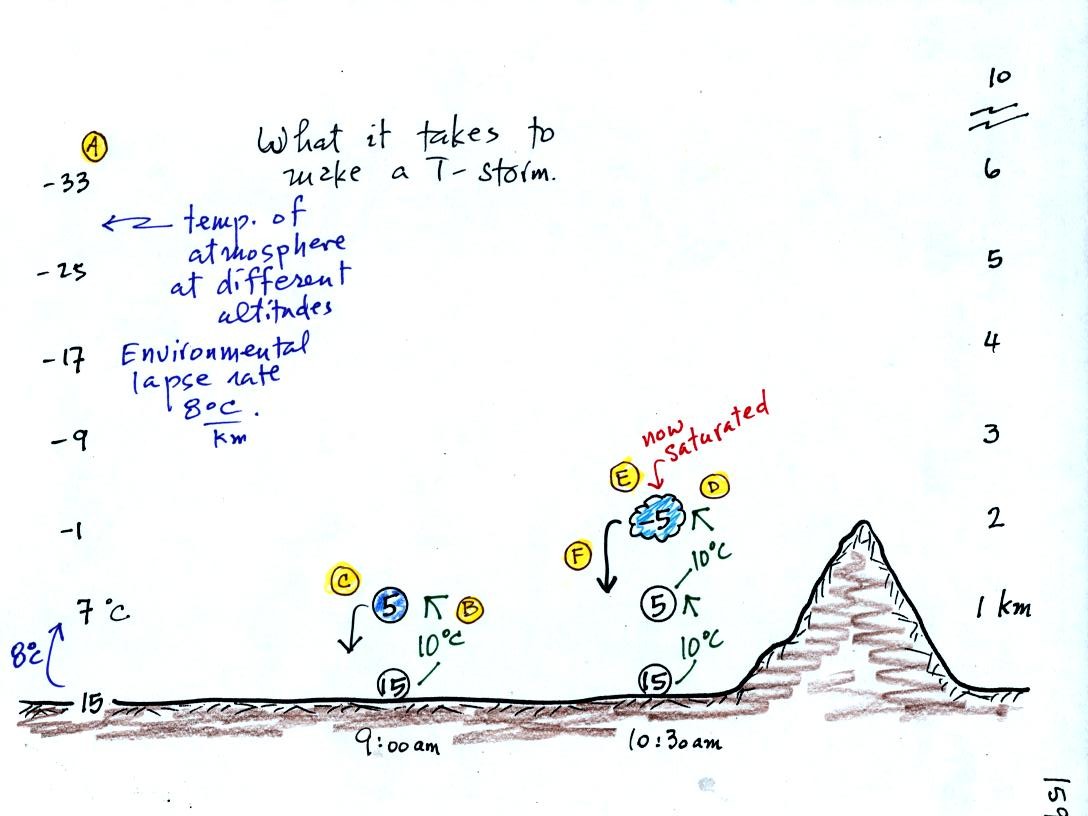
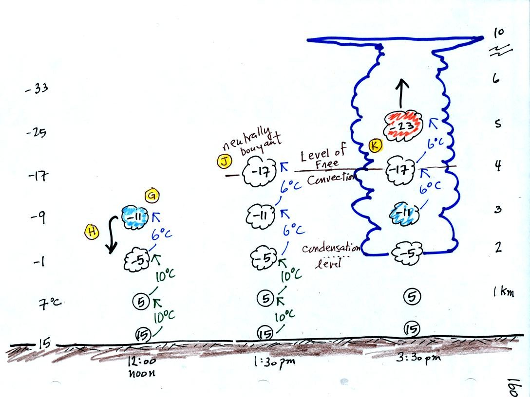
what we just covered: it takes some effort and often a good
part of the
day before a thunderstorm forms. The air must be lifted to just
above the
level of free convection. Once air is lifted above the level of
free
convection it finds itself warmer and less dense that the air around it
and
floats upward on its own. The is the
moment at
which the air mass thunderstorm begins.
The thunderstorm then goes through 3 stages.

In the first stage you would only find updrafts inside the cloud.

Once precipitation has formed and grown to a certain size, it will
begin to
fall and drag air downward with it. This is the beginning of the
mature
stage where you find both an updraft and a downdraft inside the
cloud.
The falling precipitation will also pull in dry air from outside the
thunderstorm (this is called entrainment). Precipitation will mix
with
this drier air and evaporate. The evaporation will strengthen the
downdraft
(the evaporation cools the air and makes it more
dense).
The thunderstorm is strongest in the mature stage. This is when
the
heaviest rain, strongest winds, and most of the lightning occur.
Eventually the downdraft spreads horizontally throughout the inside of
the
cloud and interferes with or cuts off the updraft. This marks the
beginning of the end for this thunderstorm.

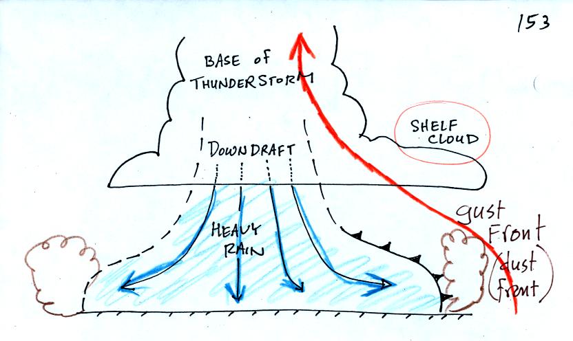
The cold downdraft air spilling out of a
thunderstorm hits the ground
and
begins to move outward from underneather
the
thunderstorm. The leading edge of this outward moving air is
called a
gust front. You can think of it as a dust front because the gust
front
winds often stir up a lot of dust here in the desert southwest.
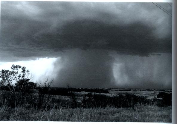
Warm moist air lifted by the gust front can form a shelf cloud.
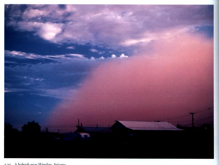
This
is a picture of a dust cloud stirred up by thunderstorm gust front
winds (taken
near
The following picture shows a shelf cloud.
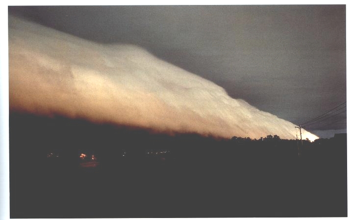
The gust front is
moving from left
to right in this picture. The shelf cloud is very close to the
ground, so
the warm air that was lifted by the gust front must have been very
moist.
It didn't have to rise and cool much before it became saturated and a
cloud
formed.

A narrow intense downdraft is called a microburst. At the ground
microburst winds will sometimes reach 100 MPH (over a limited area);
most
tornadoes have winds of 100 MPH or less. Microburst winds can
damage
homes (especially mobile homes that aren't tied to the ground), uproot
trees,
and seem to blow over a line of electric power poles at some point
every summer
in
Microbursts are a serious threat to
aircraft
especially when they are close to the ground during landing or
takeoff.
An inattentive pilot encountering headwinds at Point 1 could cut back
on the
power. Very quickly the plane would lose the headwinds (Point 2)
and then
encounter tailwinds (Point 3). The plane might lose altitude so
quickly
that it would crash into the ground before corrective action could be
taken.
Falling rain could warn of a (wet) microburst. In other cases,
dangerous
dry microburst winds might be invisible (the virga,
evaporating rain, will cool the air, make the air more dense, and
strengthen
the downdraft winds).
A simple demonstration can give you an idea of what a microburst might
look
like (I'll show the demo video in class on Thursday)
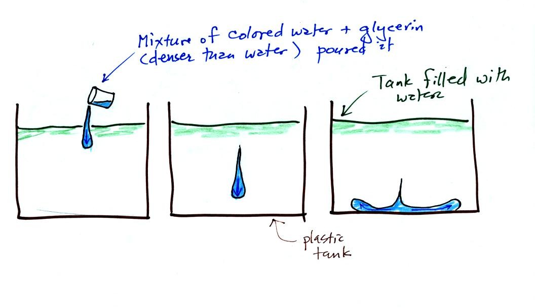
A large plastic
tank was filled
with water, the water represents air in the
atmosphere. Then a colored mixture of water and glycerin, which
is a
little denser than water, is poured into the tank. This
represents the
cold dense air in a thunderstorm downdraft. The colored liquid
sinks to
the bottom of the tank and then spreads out horizontally. In the
atmosphere the cold downdraft air hits the ground and spreads out
horizontally. These are the strong winds that can reach 100 MPH.
Here's
a picture of a wet microburst, a narrow intense thunderstorm downdraft
and
rain.
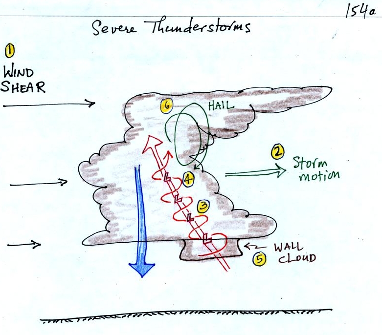
Severe
storms are more likely to form when there is vertical wind shear.
Wind
shear (pt 1) is changing wind direction or wind speed with
distance. In
this case, the wind speed is increasing with increasing altitude.
The thunderstorm itself will move in this kind of an environmen,
at an average of the speeds at the top and bottom of the cloud (pt.
2).
The thunderstorm will move to the right more rapidly than the air at
the ground
which is where the updraft begins. Rising air that is situated at
the
front bottom edge of the thunderstorm will find itself at the back edge
of the
storm when it reaches the top of the cloud. This produces a
tilted
updraft (pt. 3). The downdraft is situated at the back of the
ground. The updraft is continually moving to the right and
staying away
from the downdraft. The updraft and downdraft coexist and do not
"get in each others way."
Sometimes the tilted updraft will begin to rotate. A rotating
updraft is
called a mesocyclone (pt. 4). Meso refers to medium size (thunderstorm size)
and cyclone
means winds spinning around low pressure. Low pressure in the
core of the
mesocyclone creates an inward pointing
pressure
gradient force needed to keep the updraft winds spinning in circular
path (low
pressure also keeps winds spinning in a tornado). The cloud that
extends
below the cloud base and surrounds the mesocyclone
is
called a wall cloud (pt. 5). The largest and strongest tornadoes
will
generally come from the wall cloud.
Note (pt. 6) that a tilted updraft provides a way of keeping growing
hailstones
inside the cloud. Hailstones get carried up toward the top of the
cloud
where they begin to fall. But they then fall
back into
the strong core of the updraft and get carried back up toward the top
of the
cloud.