Thursday Oct. 29, 2009
click here to download today's notes in
a more printer friendly format
Some music
from Robert Plant and Alison Krauss from their Raising Sand CD
before class today.
The humidity Optional Assignment was collected today. Answers are
now available online. That should be it for optional assignments
until after next week's quiz.
The Experiment #3 reports are due next Tuesday. You should be
thinking about bringing your materials by my office later this week or
early next week so that you can pick
up the supplementary information handout. There's a box just
inside the door (PAS 588) where you can drop off the materials.
The preliminary version of the Quiz #3 Study
Guide is now online.
We'll spend most of today's class learning
how to identify
and name clouds. There'll be a short section on satellite
photographs of clouds at the end of the period.
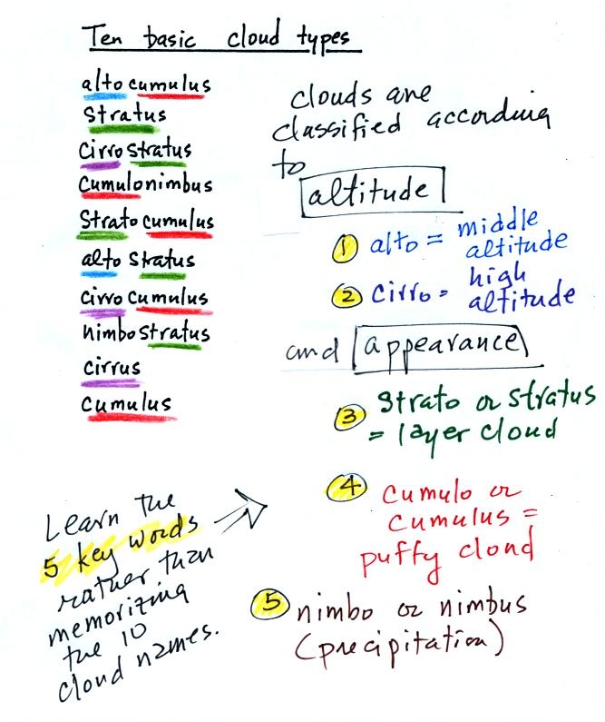
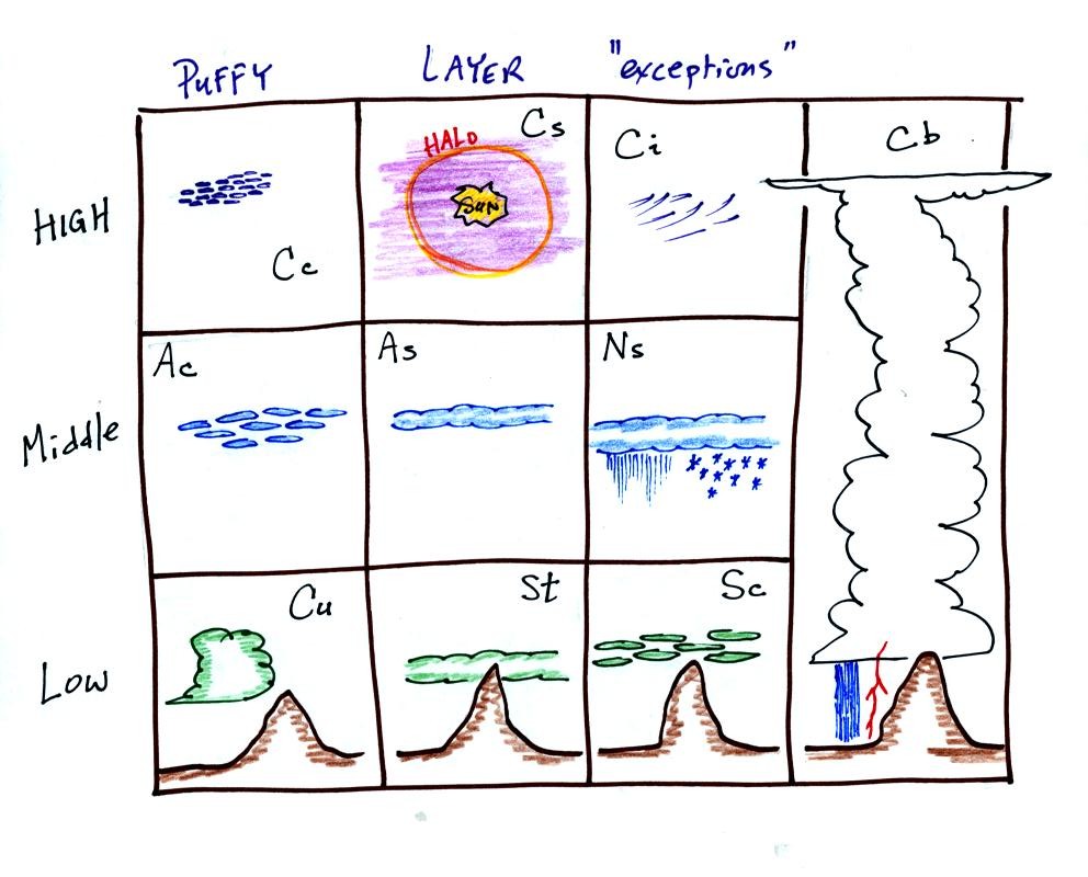
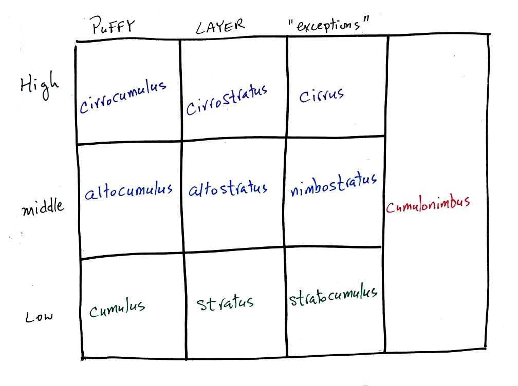
The ten main cloud types are listed below (you'll find this list on p.
95 in
the photocopied class notes).
You should try to learn these 10 cloud
names. Not just because
they might
be on a quiz (they will) but because you will be able to impress your
friends
with your knowledge. There is a smart and a not-so-smart way of
learning
these names. The not-so-smart way is to just memorize them.
You
will inevitably get them mixed up. A better way is to recognize
that all
the cloud names are made up of key words. The 5 key words, we
will
find,
mostly tell you something about the cloud altitude and appearance.
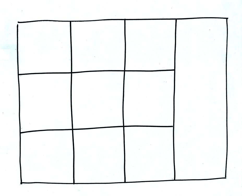
Drawing a figure like this on a blank sheet of
paper is a good way to
review
cloud identification and classification.
Each of the clouds above has a box reserved for
it in the figure.
Clouds are classified according to the altitude at which they form and
the
appearance of the cloud. There are two key words for altitude and
two key
words for appearance.
Clouds are grouped into one of three altitude
categories: high, middle
level,
and low.
Cirrus or cirro
identifies a high altitude
cloud. There are three types of clouds found in the high altitude
category..
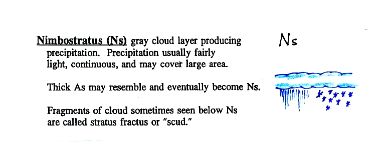
Alto in a cloud name means the cloud is found at middle altitude.
The
arrow connecting altostratus and nimbostratus indicates that they are
very
similar. When an altostratus cloud begins to produce rain or snow
its
name is changed to nimbostratus. A nimbostratus cloud is also
often somewhat
thicker and lower than an altostratus cloud. Sometimes it might
sneak into the low altitude category.
It is very hard to just look up in the sky and determine a cloud's
altitude. You will need to look for other clues to distinquish
between high and middle altitude clouds. We'll learn about some
of the
clues when we look at cloud pictures later in the class.
There is no key word for low altitude clouds. Low altitude clouds
have
bases that form 2 km or less above the ground. The summit of Mt. Lemmon in the Santa Catalina mountains
north of Tucson is about 2 km above the valley floor. Low altitude clouds will have bases that form at or
below the
summit of Mt. Lemmon.
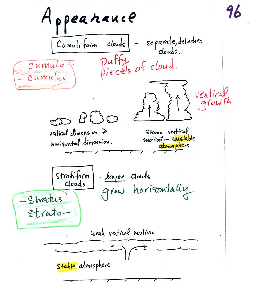
Clouds can have a patchy of puffy (or lumpy,
wavy, or ripply) appearance.
These
are cumuliform clouds and will have cumulo
or cumulus
in their name. In an unstable atmosphere cumuliform clouds will
grow vertically.
Strong thunderstorms can produce dangerous severe weather.
Stratiform clouds grow horizontally and
form
layers. They form when the atmosphere is stable.
Cirrus clouds
are sometimes considered to be a third type of cloud appearance.
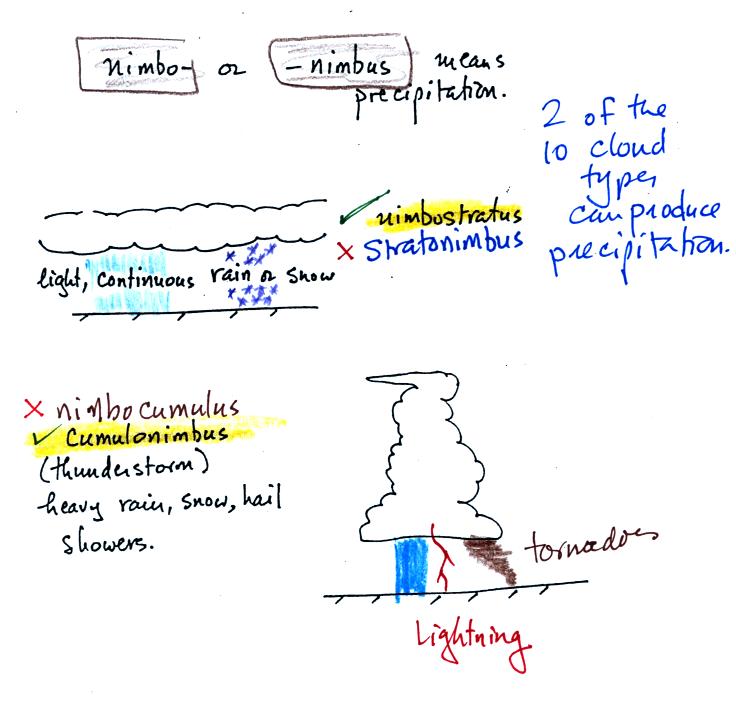
The last key word, nimbo
or nimbus, means
precipitation. Only two of the 10 cloud types are able to produce
(significant
amounts of) precipitation. It's not as easy as you might think to
make precipitation.
Nimbostratus clouds tend to produce fairly light precipitation over a
large
area. Cumulonimbus clouds produce heavy showers over localized
areas. Thunderstorm clouds can also produce hail, lightning, and
tornadoes. Hail would never fall from a
Ns
cloud.
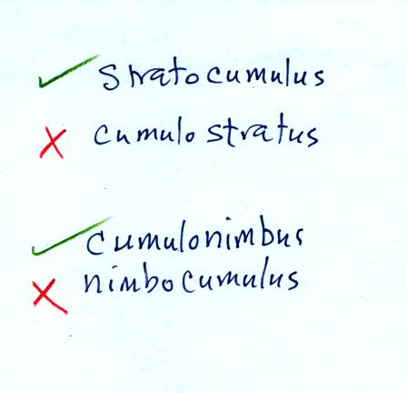
While you are still learning the cloud names you might put the correct
key
words together in the wrong order (stratonimbus
instead of nimbostratus or nimbocumulus
instead of
cumulonimbus). You won't be penalized for those kinds of errors
in this
class because you are putting together the right two key words.
Here's
the cloud chart from earlier. We've added the three altitude
categories
along the vertical side of the figure and the two appearance categories
along
the top. By the end of the class we will add a picture to each of
the
boxes.
Next
we looked at 35 mm slides of most of the 10 cloud types.
You'll find the
written
descriptions of the cloud types in the images below on pps
97-98 in the photocopied notes.
High altitude clouds
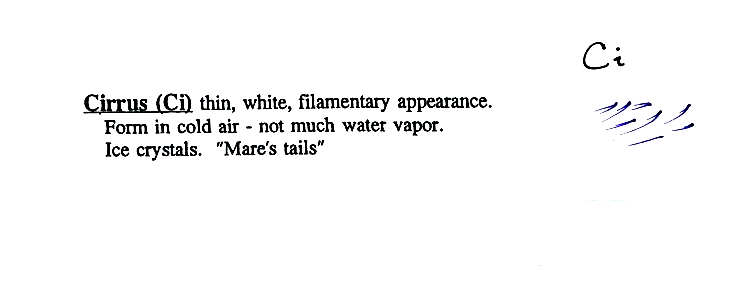
High altitude
clouds
are thin
because the air at high altitudes is very cold and cold air can't
contain much
moisture (the saturation mixing ratio for cold air is very
small). These
clouds are also often blown around by fast high altitude winds.
Filamentary means "stringy" or "streaky". If you
imagine trying to paint a Ci cloud you
would dip a
small pointed brush in white paint brush it quickly and lightly across
a blue
colored canvas.

A
cirrostratus cloud is a thin uniform white layer cloud (not purple as
shown in
the figure) covering part or all of the sky. They're so thin you
can
sometimes see blue sky through the cloud layer. Haloes are a
pretty sure
indication that a cirrostratus cloud is overhead. If you were
painting Cs
clouds you could dip a broad brush in white paint (diluted perhaps with
water)
and then paint back and forth across the canvas.
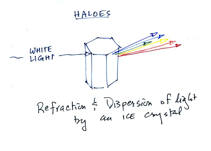
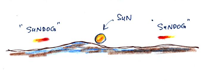
Haloes
are
produced by
white light
entering a 6 sided ice crystal is bent (refraction). The amount
of
bending depends on the color (wavelength) of the light
(dispersion). The
white light is split into colors just as light passing through a glass
prism. This particular crystal is called a column and is fairly
long.

This is a flatter crystal and is
called a plate. These crystals
tend to
all be horizontally oriented and produce sundogs. A sketch of a
sundog is
shown below.
Sundogs are
pretty
common and are
just patches of light seen to the right and left of the rising or
setting sun.
Cirrus and cirrostratus clouds are fairly common. Cirrocumulus
clouds are
a little more unusual.
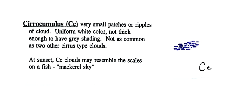
To
paint a Cc cloud you would dip a sponge in white paint and press it
gently
against the canvas. You would leave a patchy, splotchy appearing
cloud
(sometimes you might see small ripples). It is the patchy (or
wavy)
appearance that makes it a cumuliform cloud.
middle
altitude clouds

Altocumulus
clouds are pretty common. Note since it is
hard to
accurately judge altitude, you must rely on cloud element size
(thumbnail size
in the case of Ac) to determine whether a cloud belongs in the high or
middle
altitude category. The cloud elements in Ac clouds appear
larger
than in Cc because the cloud is closer to the ground.
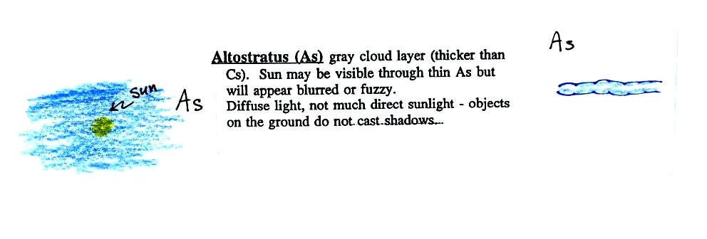
Altostratus
clouds are
thick
enough that you probably won't see a shadow if you look down at your
feet. The sun may or may not be visible through the cloud. When (if) an altostratus cloud begins to produce
precipitation, its
name is changed to nimbostratus.
Low altitude clouds
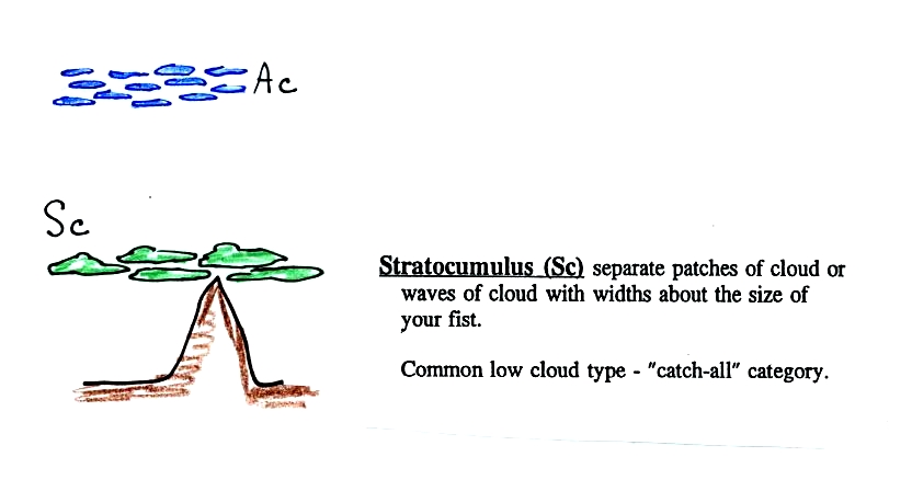
This cloud name
is a
little
unusual because the two key words for cloud appearance have been
combined. Because they are closer to the ground, the separate
patches of
Sc are about fist size. The patches of Ac, remember, were about
thumb
nail size.
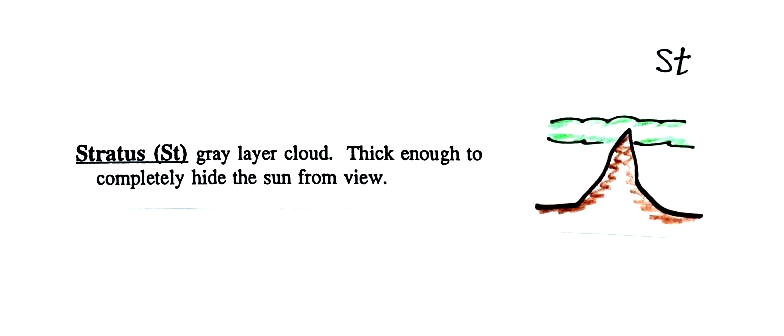
No pictures of
stratus
clouds were
shown in class.
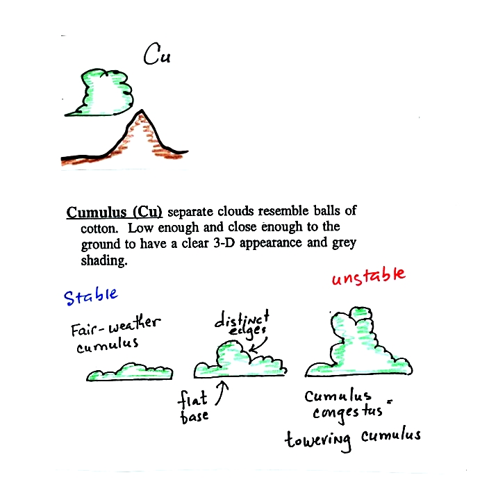
Cumulus clouds
come
with different
degrees of vertical development. The fair weather cumulus clouds
don't
grow much vertically at all. A cumulus congestus
cloud is an intermediate stage between fair weather cumulus and a
thunderstorm.
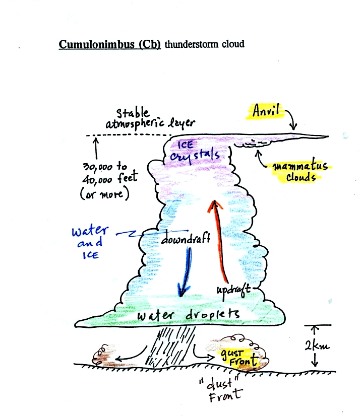
There are lots of
distinctive
features on cumulonimbus clouds including the flat anvil top and the
lumpy mammatus clouds sometimes found on
the underside of the
anvil. Cold dense downdraft winds hit the ground below a
thunderstorm and
spread out horizontally underneath the cloud. The leading edge of
these
winds produces a gust front (dust front might be a little more
descriptive).
Winds at the ground below a thunderstorm can exceed 100 MPH, stronger
than many
tornadoes. The top of a thunderstorm is cold enough that it will
be
composed of just ice crystals. The bottom is composed of water
droplets. In the middle of the cloud both water droplets and ice
crystals
exist together at temperatures below freezing (the water droplets have
a hard
time freezing). Water and ice can also be found together in
nimbostratus
clouds. We will see that this mixed phase region of the cloud is
important
for precipitation formation. It is also where the electricity
that
produces lightning is generated.
Here's one final feature to look for at the bottom of a
thunderstorm.
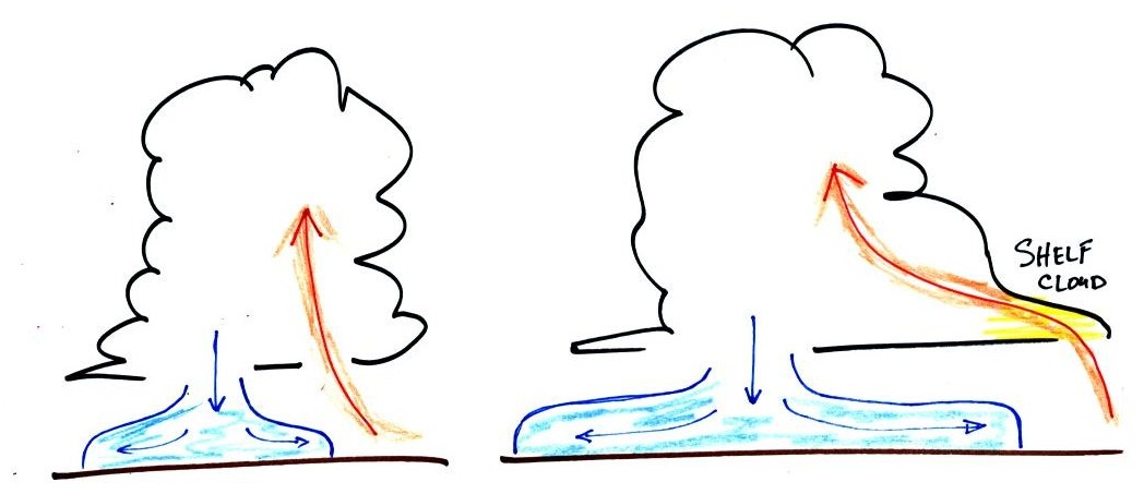
Cold air spilling
out
of the base
of a thunderstorm is just beginning to move outward from the bottom
center of
the
storm in the picture at left. In the picture at right the
cold air
has moved further outward and has begun to get in the way of the
updraft.
The updraft is forced to rise earlier and a little ways away from the
center of
the thunderstorm. Note how this rising air has formed an extra
lip of
cloud. This is called a shelf cloud.
Here's the
completed cloud chart. One day you'll be able to buy a NATS 101
Intro. to Weather & Climate T-shirt. This is what will be on
it.
This is a logical time to learn a little bit about the 2
most common types of satellite photographs. You'll find this
discussed on pps 99-100 in the photocopied ClassNotes. Throw
those old notes away, the figures below are better and were on a
handout distributed in class.
When you see satellite photographs
of clouds on the TV weather you are probably seeing an infrared
satellite photograph.
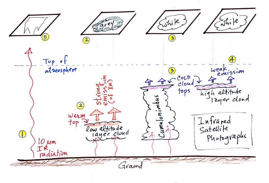
1. An infrared satellite photograph detects the 10 um IR
radiation
actually
emitted by the ground, the ocean and by clouds. You don't depend
on seeing
reflected
sunlight, so clouds
can be photographed during the day and at
night. You may recall that 10 um radiation is in the
middle of
the atmospheric window, so this radiation is able to pass through air
without being absorbed. If clouds don't get in the way, you can
see the ground on an IR photograph.
2. Clouds absorb 10 um radiation and then reemit
IR radiation. The top surface of a low altitude cloud will be
relatively warm. Warmer objects emit IR radiation at a greater
rate or at higher intensity (the Stefan Boltzmann law).
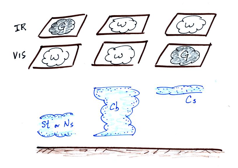
This is shown as grey on an IR satellite photograph. A
grey unimpressive looking cloud on an IR
satellite photograph may actually be a thick nimbostratus cloud that is
producing a lot of rain or snow.
3. Cloud tops found at high altitude are cold and emit
IR
radiation at a lower rate or lower intensity. This shows up
white on an IR photograph.
4. Two very different clouds (a thunderstorm and a
cirrostratus cloud) would both appear white on the satellite photograph
and would be difficult to distinquish. Meteorologists are
interested in locating tall thunderstorms because they can produce
severe
weather.
5. The ground changes temperature during the course of
the
day. On an infrared satellite animation you can watch the ground
change from dark grey or black (afternoon when
the ground is warmest) to lighter grey (early morning when the ground
is cold)
during the course of a day. Because of water's high specific
heat, the ocean right alongside doesn't
change temperature much during the day and remains grey throughout the
day. Here's a link
to an IR satellite photograph loop on the UA Atmospheric Sciences Dept.
webpage.
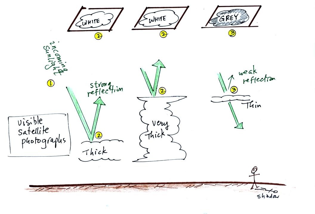
A visible satellite photograph
photographs sunlight that is
reflected
by clouds. You won't see much on a visible satellite photograph
at night. Thick clouds are good reflectors and appear
white. Thinner clouds don't reflect as much light and appear
grey. The low altitude layer cloud and the thunderstorm would
both appear white on this photograph and would be difficult to
distinquish.
Here's a summary of what we have
learned so far. The figure
above wasn't shown in class.
The figure below shows
how
if you combine both visible and IR
photographs you can begin to distinquish between different types of
clouds.
Note
You'll probably find some introductory material on precipitation
producing processes online before class next Tuesday. Have a
quick look at it, if you have time, so that you can familiarize
yourself with some of the material before coming to class.