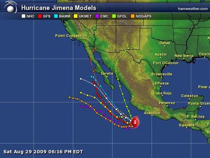
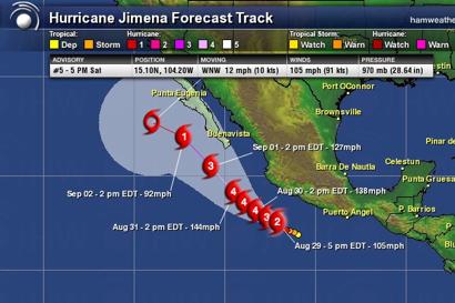
Eastern Pacific Hurricane JIMENA National Hurricane Center (NHC)
Webcams to watch Jimena at Cabo San Lucas: http://www.cabovillas.com/campage.asp?id=1
Links to results of WRF model run on campus
http://www.atmo.arizona.edu/products/models/wrf_d01_0/wind10m.html
http://www.atmo.arizona.edu/products/models/wrf_d01_0/wrf_precip_tot.html
Hurricane JIMENA Public Advisory Number 16A
September 1, 2009 10:48 AM
...JIMENA WEAKENS A LITTLE MORE BUT REMAINS AT CATEGORY
FOURSTRENGTH...
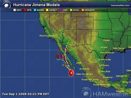
Location: 21.5°N 111.0°W, Max sustained: 135 mph, Moving: NNW at 12 mph,
Min pressure: 948 mb
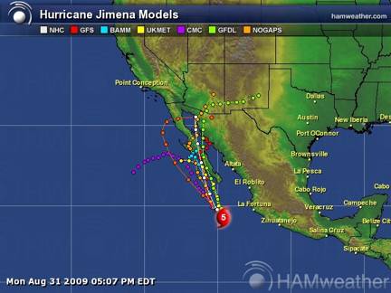
August 31, 2009 11:00 MST: NHC public advisory 14 indicates JIMENA has sustained winds of 155 mph making it a category 5 hurricane
August 31, 2009 02:30 PM MST: JIMENA is now within 3 mph of a category 5 hurricane (see below)
HURRICANE JIMENA DISCUSSION NUMBER 13
NWS TPC/NATIONAL HURRICANE CENTER MIAMI FL EP132009
200 PM PDT MON AUG 31 2009
THE AIR FORCE RESERVE HURRICANE HUNTERS HAVE JUST COMPLETED THEIR MISSION IN JIMENA...AND FOUND THAT THE HURRICANE WAS STRONGER THAN PREVIOUSLY ESTIMATED. PEAK 700 MB FLIGHT-LEVEL WINDS WERE 149 KT (171 mph) AND THE MAXIMUM SFMR-MEASURED SURFACE WINDS WERE 132 KT (152 mph) OVER THE NORTHEAST QUADRANT. THE SFMR ALSO MEASURED 128 KT (147 mph) IN THE NORTHWEST EYEWALL AND 125 KT IN THE SOUTHWEST PART OF THE EYEWALL. A MINIMUM CENTRAL PRESSURE OF 931 MB WAS MEASURED BY DROPSONDE. THE CURRENT INTENSITY IS ADJUSTED UPWARD TO 135 KT...AT THE VERY HIGH END OF CATEGORY 4 STATUS. FLUCTUATIONS IN STRENGTH ARE LIKELY DURING THE NEXT DAY OR SO DUE TO INNER CORE EVENTS...PRIMARILY EYEWALL REPLACEMENTS. HOWEVER THE SHIPS MODEL INDICATES A GRADUAL DECREASE IN OCEANIC HEAT CONTENT AND SOME INCREASE IN WEST-SOUTHWESTERLY SHEAR DURING THE NEXT 36 HOURS. HOWEVER THESE ENVIRONMENTAL INFLUENCES SHOULD NOT PREVENT JIMENA FROM MAINTAINING MAJOR HURRICANE STRENGTH PRIOR TO LANDFALL.
August 31, 2009 07:30 AM MST: maintaining strength: 145 mph winds, 940 mb central pressure, Location: 17.8°N 108.1°W, moving NW at 8 mph
GFDL model now has what will be a tropical storm remnant coming over Tucson
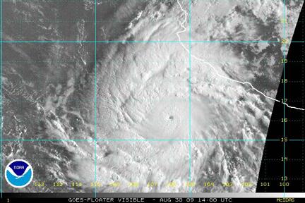
August 30, 2009 08:00 PM MST: increasing strength: 145 mph winds, 940 mb central pressure, Location: 17.0°N 107.2°W, moving NW at 7 mph
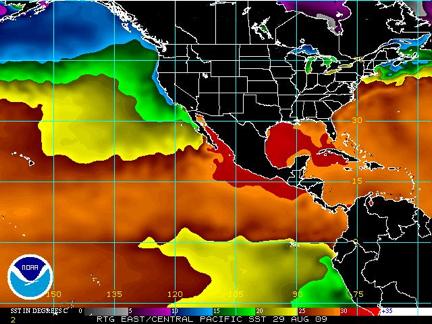
August 30, 2009 06:00 PM MST: Jimena is now a category 4 hurricane with 140 mph winds and a central pressure of 945 mb south of Cabo San Lucas at the tip of Baja moving northwest. Many of the model forecasts have shifted the hurricane track slightly to the east so that it will make landfall on Baja. The Navy’s NOGAPS model still has the closest track to Tucson. The GFDL model is still farthest to the east. The water temperature in the Gulf of California (GoC) is very warm so if the hurricane goes into the GoC it may get somewhat stronger or at least maintain its strength depending on how deep the warm water is.
