Friday Nov. 12, 2010
click here to download today's notes in a more printer friendly format

A couple of songs from Duffy ("Rockferry" and "Mercy") before class today.

The Experiment #3 reports have been graded.  Revised reports are due by Monday Nov. 29, though if you could get them in before Thanksgiving that would be helpful.  Please return your original report with your revised report.

The 1S1P Assignment #2b reports were collected today.  That's it for Assignment #2.  There'll be one more assignment and probably a Bonus Assignment.


Class on Wednesday was pretty close to a complete disaster.  You'd think I would be happy to leave bad memories like thermal circulations and the 3-cell model material behind.  But no, here's some review.

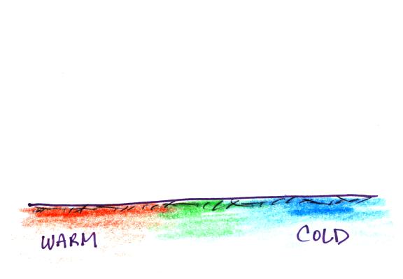
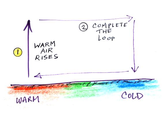
What would the thermal circulation look like in this case?  This is an easy question if you remember the short cut I mentioned in class on Wednesday.


Remember that warm air rises, draw an upward pointing arrow above the warm part of the picture and then complete the loop. 

We reviewed several thermal circulation examples that were inserted into the Wednesday lecture notes
("city breeze", Asian summer and winter monsoon, El Nino, and La Nina) even though they weren't covered in class.   A couple were reviewed in class today


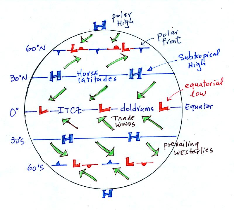
This figure shows all of the 3-cell model surface features.  You'll see it again on the Quiz #4 Study Guide.


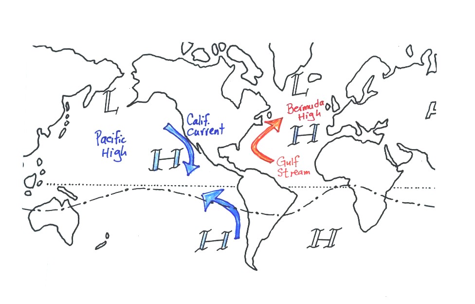
The 3-cell model predicts subtropical belts of high pressure near 30 latitude.  The 3-cell model makes some unrealistic assumptions such as requiring that the earth be of uniform composition.  In the real world we don't find belts of high pressure at 30 latitude but there are large circular centers of high pressure.  In the northern hemisphere the Bermuda high is found off the east coast of the US, the Pacific high is positioned off the west coast.  High pressure centers are found east and west of South America in the southern hemisphere.  Since I can't remember their names, you don't have to either.

Circular low pressure centers, the Icelandic low (off the east coast near Iceland and Greenland in the picture below) and the Aleutian low (off the west coast near the southern tip of Alaska), are found near 60 N.  There's very little land in the southern hemisphere between 30 S and 60 S.  There is a belt of low pressure found there just as is predicted in the 3-cell model.  Names like "roaring 40s" and "ferocious 50s" refer to strong surface winds that develop near 40 and 50 degrees southern latitude in the winter.
 

The winds that blow around the large scale high pressure centers create some of the major ocean currents of the world.  If you remember that high pressure is positioned off the east and west coast of the US, and that winds blow clockwise around high in the northern hemisphere, you can determine the directions of the ocean currents flowing off the east and west coasts of the US.  The Gulf Stream is a warm current that flows from south to north along the east coast, the California current flows from north to south along the west coast and is a cold current.  A cold current is also found along the west coast of South America; winds blow counterclockwise around high in the southern hemisphere. 


We'll be spending a day or two talking about thunderstorms next week (sections on tornadoes and lightning will follow)

The following somewhat repetitious material is intended to prepare you to better appreciate a time lapse video movie of a thunderstorm developing over the Catalina mountains.

I don't expect you to remember all of the details given below.  The figures below are more carefully drawn versions of what was done in class.


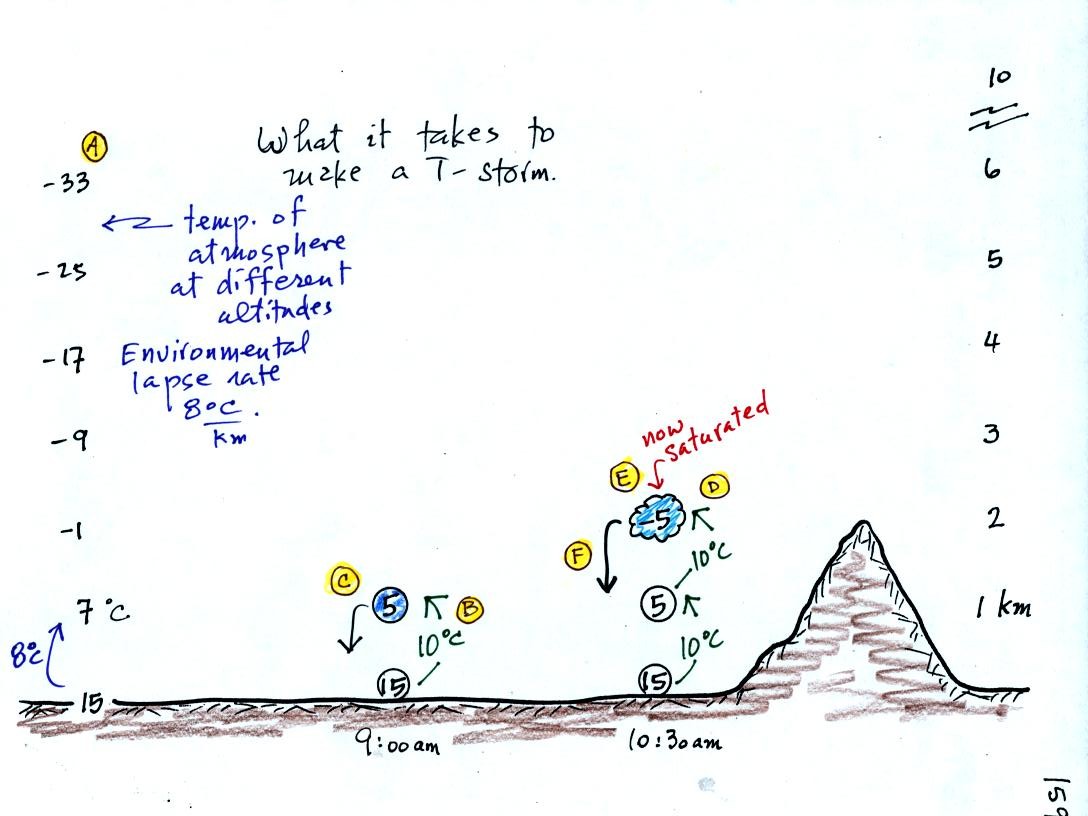
Refer back and forth between the lettered points in the figure above and the commentary below.

The numbers in Column A show the temperature of the air in the atmosphere at various altitudes above the ground (note the altitude scale on the right edge of the figure).  On this particular day the air temperature was decreasing at a rate of 8 C per kilometer.  This rate of decrease is referred to as the environmental lapse rate (lapse rate just means rate of decrease with altitude).  Temperature could decrease more quickly than shown here or less rapidly.  Temperature in the atmosphere can even increase with increasing altitude (a temperature inversion).

At Point B, some of the surface air is put into an imaginary container, a parcel.  Then a meterological process of some kind lifts the air to 1 km altitude (in Arizona in the summer, sunlight heats the ground and air in contact with the ground, the warm air becomes bouyant - that's called free convection).  The rising air will expand and cool as it is rising.  Unsaturated (RH is less than 100%) air cools at a rate of 10 C per kilometer.  So the 15 C surface air will have a temperature of 5 C once it arrives at 1 km altitude. 

"Mother Nature" lifts the parcel to 1 km and "then lets it go."  At Point C note that the air inside the parcel is slightly colder than the air outside (5 C inside versus 7 C outside).  The air inside the parcel will be denser than the air outside and the parcel will sink back to the ground. 

By 10:30 am the parcel is being lifted to 2 km as shown at Point D.  It is still cooling 10 C for every kilometer of altitude gain.  At 2 km, at Point E
  the air has cooled to its dew point temperature and a cloud has formed.  Notice at Point F, the air in the parcel or in the cloud (-5 C) is still colder and denser than the surrounding air (-1 C), so the air will sink back to the ground and the cloud will disappear.  Still no thunderstorm at this point.


At noon, the air is lifted to 3 km.  Because the air became saturated at 2 km, it will cool at a different rate between  2 and 3 km altitude.  It cools at a rate of 6 C/km instead of 10 C/km.  The saturated air cools more slowly because release of latent heat during condensation offsets some of the cooling due to expansion.  The air that arrives at 3km, Point H, is again still colder than the surrounding air and will sink back down to the surface.

By 1:30 pm the air is getting high enough that it becomes neutrally bouyant, it has the same temperature and density as the air around it (-17 C inside and -17 C outside).  This is called the level of free convection, Point J in the figure.

If you can, somehow or another,  lift air above the level of free convection it will find itself warmer and less dense than the surrounding air as shown at Point K and will float upward to the top of the troposphere on its own.  This is really the beginning of a thunderstorm.  The thunderstorm will grow upward until it reaches very stable air at the bottom of the stratosphere.

A time lapse video of some thunderstorm development was shown in class.  I'll show a better example on Monday.  As in the example above, it often takes most of a day's worth of work before a thunderstorm is initiated.


Next we did a demonstration that normally is done earlier in the semester.  It fits in well with what we have been covering concerning thunderstorm development.  I.e. air will either rise or sink depending on whether it is less dense or more dense than the air surrounding it.

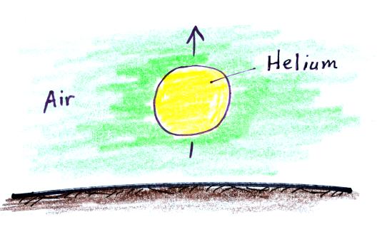
We used balloons filled with helium (see bottom of p. 54 in the photocopied Class Notes).  Helium is less dense than air even when the helium has the same temperature as the surrounding air.  A helium-filled balloon doesn't need to warmed up in order to rise.

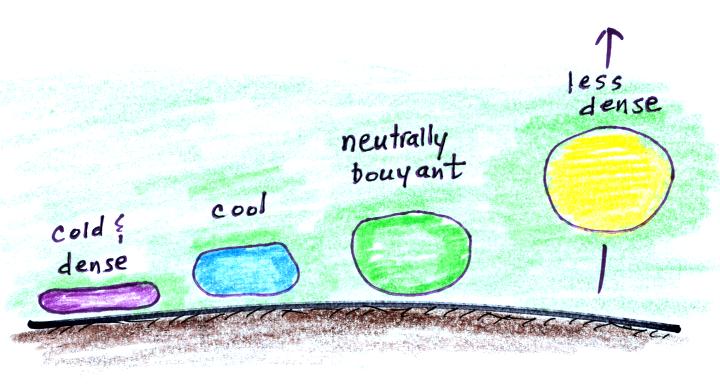
We dunked the helium-filled balloon in some liquid nitrogen to cool it.  The balloon shrinks in size, increasing the density of the helium inside. 


When removed from the liquid nitrogen the balloon didn't rise, the gas inside was denser than the surrounding air (the purple and blue balloons in the figure above).  As the balloon warms and expands its density decreases.  The balloon at some point has the same density as the air around it (green above) and is neutrally bouyant.  Eventually the balloon warms to room temperature, becomes less dense that the surrounding air (yellow) just as it was initially and floats up to the ceiling.


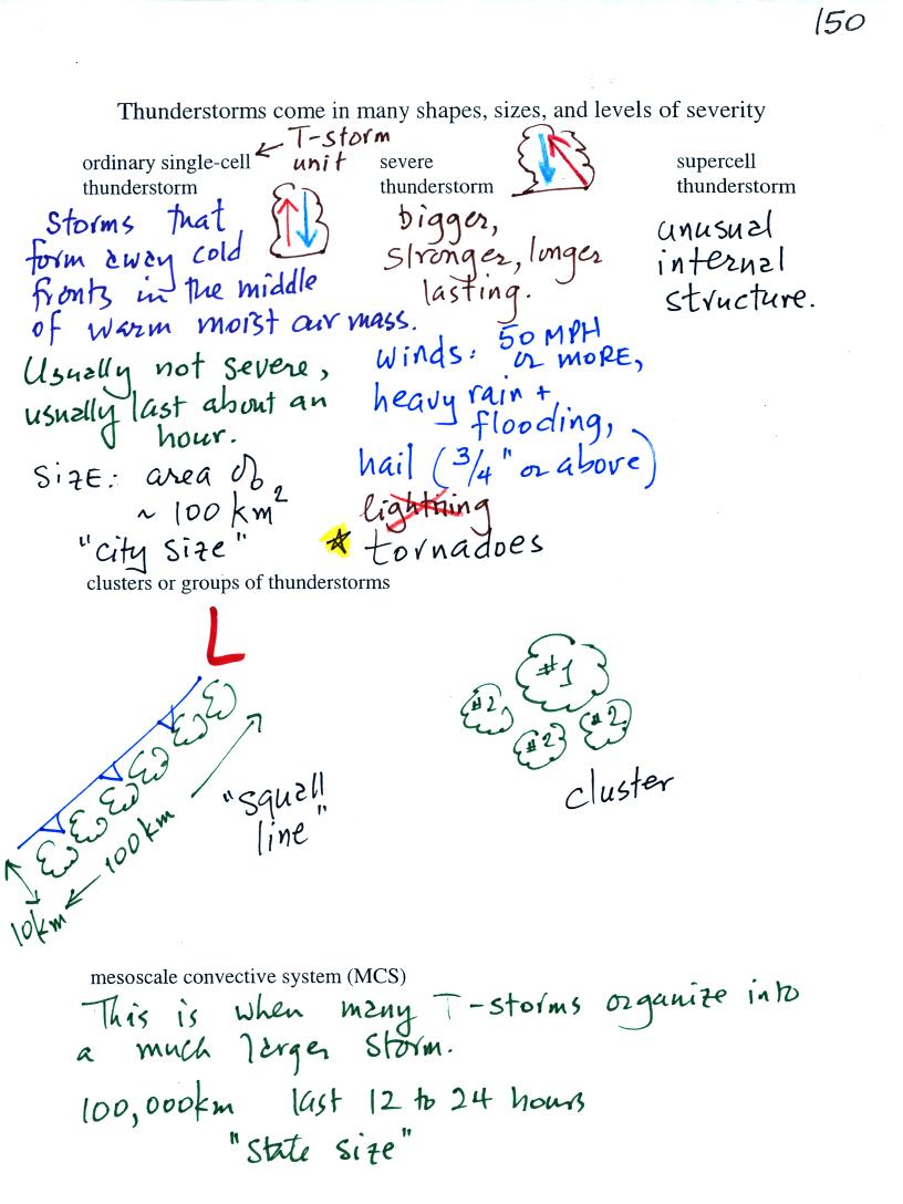
We had enough time to cover p. 150 in the photocopied ClassNotes, an introduction to thunderstorms.

Thunderstorms come in different sizes and levels of severity.  We will mostly be concerned with ordinary single-cell thunderstorms (also referred to as air mass thunderstorms).  The word cell just refers to a single storm unit.  Most summer thunderstorms in Tucson are this type.   An air mass thunderstorm has a vertical updraft.

Tilted updrafts are found in severe and supercell thunderstorms.  As we shall see this allows those storms to get bigger, stronger, and last longer.  Storms with strong updrafts can produce large hailstonges.  Sometimes the tilted updraft will begin to rotate, this can produce tornadoes.  Supercell thunderstorms have a complex internal structure.  We'll watch a short video that shows a computer simulation of the complex air motions inside a supercell thunderstorm.

Thunderstorms often form in clusters or lines.  This is a multiple cell storm system and can cover a larger area.

We won't learn much about mesoscale convective systems or mesoscale convective complexes.  These are much larger, "state size", storm systems that can last 12 to 24 hours.