Thursday Nov. 15, 2012
Some bicycling from the Tour de France instead of music this
morning, to celebrate the 30th running of El Tour de Tucson this coming
weekend (1000s of bicyclists will be out riding around the perimeter of
Tucson on Saturday). In the video Lance Armstrong and Marco
Pantani were racing up to the summit of Mont Ventoux in SE
France. You can watch the end of the stage and see who won here.
The Scientific Paper reports have been graded and were returned in
class today. You can revise those reports if you want to.
The revised reports are due by Thu., 11/29. Please return the
original report with your revised report. We're reaching the
point in the semester where you should have completed a report of
somekind. Here's a list of
students that my records show haven't yet completed a report.
It's looking like the grade summaries will be delayed until next
Tuesday also so that the Sci. Paper report grades and the revised Expt.
#2 grades can be included.
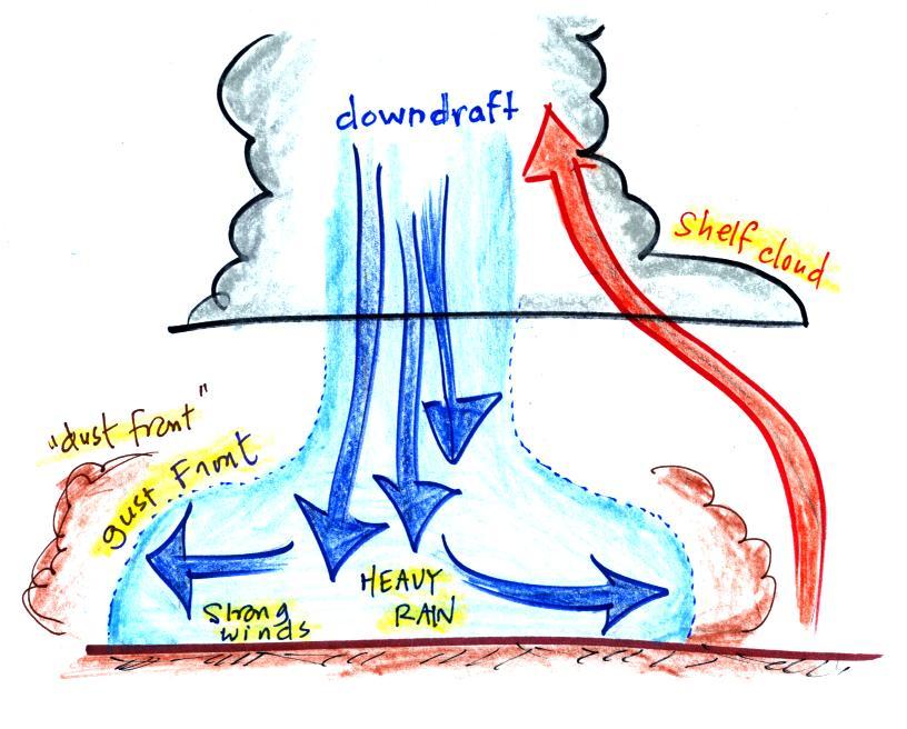
The
picture below shows some of the features at the base of a thunderstorm.
The
cold downdraft air spilling out of
a
thunderstorm hits the ground
and
begins to move outward from underneather
the
thunderstorm. The leading edge of this outward moving air is
called a
gust front. You can think of it as a dust front because the gust
front
winds often stir up a lot of dust here in the desert southwest (see
below).
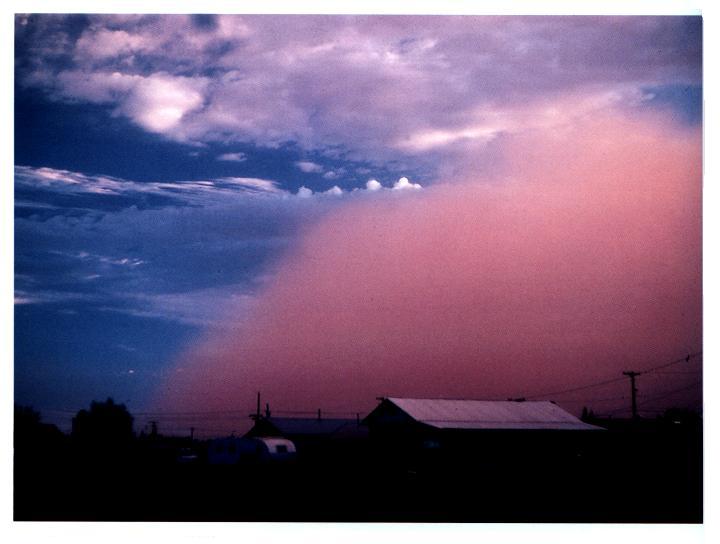
The
gust front in this picture (taken
near Winslow, Az) is moving from the right
to the
left. Visibility in the dust cloud can drop to
near zero which
makes this
a serious
hazard to automobile traffic. Dust storms like this are
sometimes called "haboobs".
There's lots of video on YouTube of an impressive dust storm this
past summer. Here's an example from
Gilbert Arizona. Another from
South Mountain (same storm seen from a different location).
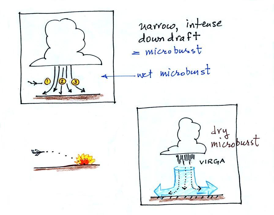
A
narrow intense downdraft is called a microburst. At the ground
microburst winds will sometimes reach 100 MPH (over a limited area);
most
tornadoes have winds of 100 MPH or less. Microburst winds can
damage
homes (especially mobile homes that aren't tied to the ground), uproot
trees,
and seem to blow over a line of electric power poles at some point
every summer
in Tucson (sometimes trapping people in automobiles
underneath live power wires).
Microbursts
are a serious threat to
aircraft
especially when they are close to the ground during landing or
takeoff.
An inattentive pilot encountering headwinds at Point 1 might cut back
on the
power. Very quickly the plane would lose the headwinds (Point 2)
and then
encounter tailwinds (Point 3). The plane might lose altitude so
quickly
that it would crash into the ground before corrective action could be
taken. Microburst associated wind shear was largely responsible
for the crash of Delta Airlines Flight 191 while landing at the Dallas
Fort Worth airport on Aug. 2, 1985 (click here to watch a
simulation of the final approach into the airport, I don't show it in
class because it contains some of the actual cockpit communications).
Falling rain could warn of a wet
microburst (see photo below). In other cases,
dangerous
dry microburst winds might be invisible (the virga,
evaporating
rain,
will
cool
the
air,
make
the
air
more
dense,
and
strengthen
the
downdraft
winds).
In other cases,
dangerous
dry microburst winds might be invisible (the virga,
evaporating
rain,
will
cool
the
air,
make
the
air
more
dense,
and
strengthen
the
downdraft
winds).
Another of my homemade videos tries to hammer home the idea of
what a microburst and gust front
might look like.
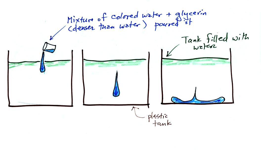
In
the
video a large
plastic
tank was filled
with water, the water represents air in the
atmosphere. Then a colored mixture of water and glycerin, which
is a
little denser than water, is poured into the tank. This
represents the
cold dense air in a thunderstorm downdraft. The colored liquid
sinks to
the bottom of the tank and then spreads out horizontally. In the
atmosphere the cold downdraft air hits the ground and spreads out
horizontally. These are the strong winds that can reach 100
MPH.
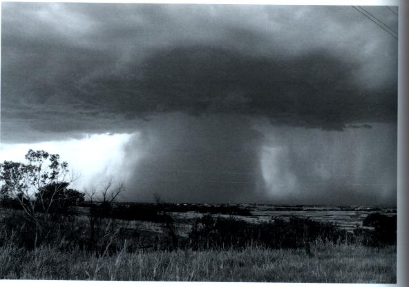
Here are three microburst videos from
YouTube.
The first
video shows a microburst from some distance away. The second video was
taken in the heavy rain and strong winds under a thunderstorm in the
microburst. You'll see a power pole snapped in half by the
microburst winds at about 2:26 in the video. Here's
a
third video
of a microburst that hit Princeton KS in July 2009. Someone
watching the storm estimated the winds were at least 90 MPH. Try
to imagine being caught outdoors during the last video, you would have
difficulty walking. And if there were any debris being blown
around by the winds you'd be at some risk of serious injury.
The
following
picture shows a
shelf
cloud (a thunderstorm cloud feature mentioned earlier in the semester
when we were learning to name clouds).
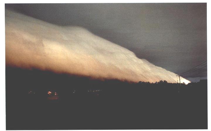
Shelf clouds are even more impressive on
video. Here are a couple of pretty good
examples (Grand
Haven, MI
and Massillon, OH).
Next we need to look at some
of the conditions that can lead to severe thunderstorm
formation and some of the characteristics of these storms. Severe
thunderstorms last
longer, grow bigger, and become stronger than ordinary air mass
thunderstorms. They can also produce tornadoes.
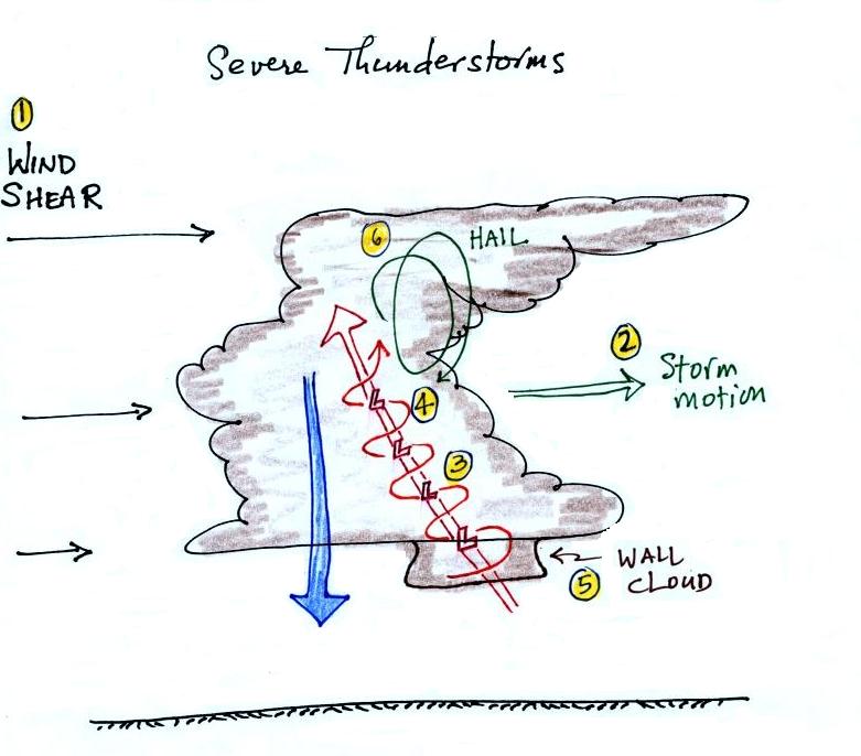
Severe
storms are more likely to form when there is vertical wind shear (the
picture above is on p. 154a in the ClassNotes).
Wind
shear (pt 1) is changing wind direction and/or wind speed with
distance. In
the case shown above, the wind speed is increasing with increasing
altitude, this
is vertical wind shear.
A thunderstorm that forms in this kind of an environment
will move at an average of the speeds at the top and bottom of the
cloud (pt.
2).
The thunderstorm will move to the right more rapidly than the air at
the ground
which is where the updraft begins. Rising air that is situated at
the
front bottom edge of the thunderstorm will find itself at the back edge
of the
storm when it reaches the top of the cloud.
This produces a
tilted
updraft (pt. 3). The downdraft is situated at the back of the
ground. The updraft is continually moving to the right and
staying away
from the downdraft. The updraft and downdraft coexist and do not
"get in each others way." If you remember in air mass
thunderstorms, the downdraft gets in the way of the updraft and leads
to dissipation of the storm.
Sometimes
the
tilted
updraft
will
begin
to
rotate.
A
rotating
updraft
is
called
a
mesocyclone
(pt. 4). Meso refers to medium size
(thunderstorm size)
and cyclone
means winds spinning around low pressure (tornadoes are sometimes
called cyclones). Low pressure in the
core of the
mesocyclone creates an inward pointing
pressure
gradient force needed to keep the updraft winds spinning in circular
path.
The cloud that
extends
below the cloud base and surrounds the mesocyclone
is
called a wall cloud (pt.
5). The largest and strongest tornadoes
will
generally come from the wall cloud. We'll see some pretty
dramatic videos of wall clouds on Friday when we finish this section on
tornadoes.
Note (pt. 6) that a tilted updraft also provides a way of keeping
growing
hailstones
inside the cloud. Hailstones get carried up toward the top of the
cloud
where they begin to fall. But they then fall
back into
the strong core of the updraft and get carried back up toward the top
of the
cloud.
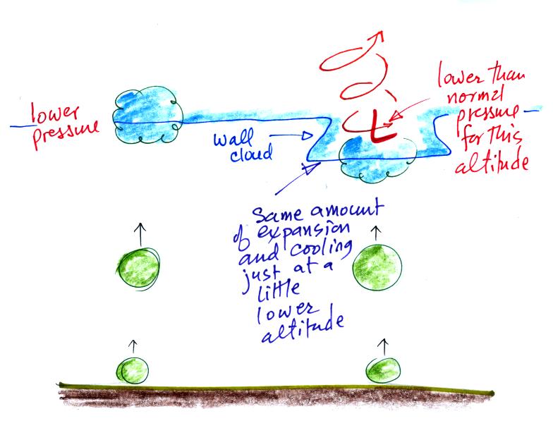
A wall cloud can form a little bit
below the rest of the base of the thunderstorm. Clouds normally
form when air
rises, expands, and cools as shown above at left. The rising air
expands because it is moving into lower pressure surroundings at higher
altitude. Only when the air has risen high enough, moved into low
enough pressure, expanded and cooled enough will a cloud form.
At right the air doesn't have to rise to as high an altitude to
experience the same amount of expansion and cooling. This is
because it is moving into the core of the rotating updraft where the
pressure is a little lower than normal for this altitude. Cloud
formation is a little bit closer to the ground.
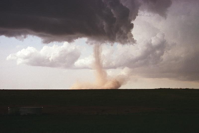
Here's a picture of a portion of
the bottom of a thunderstorm with a wall cloud and, what appears to be,
a relatively weak tornado (narrow diameter and almost transparent).
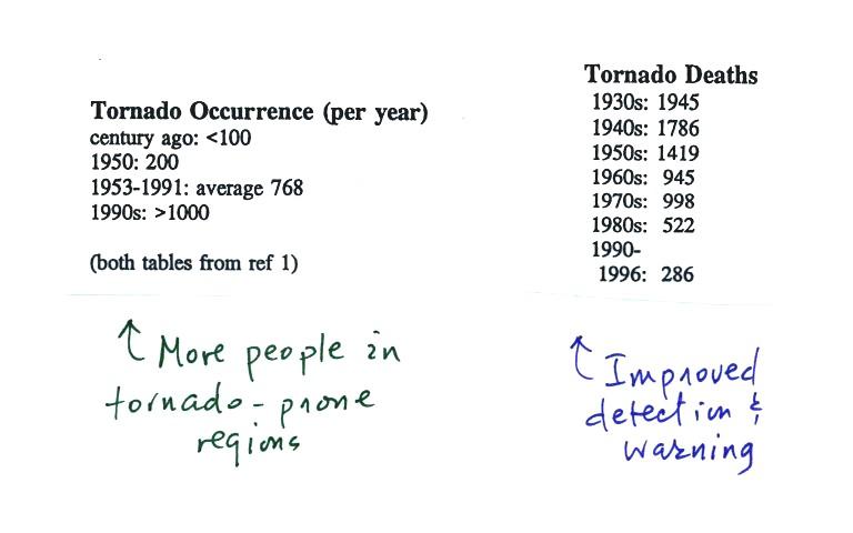
The
United
States
has
roughly 1000 tornadoes in an average year. That is more than
any
other country in the world .
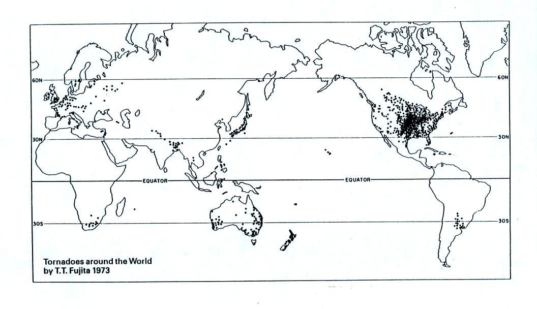
A
year's
worth of tornado activity plotted on a world map. Part
of
the
reason
why the central
US
has
some
many
tornadoes is just a consequence of geography.
Without
any
mountains
in
the
way,
cold
dry
air
can
move
in the spring all the way
from
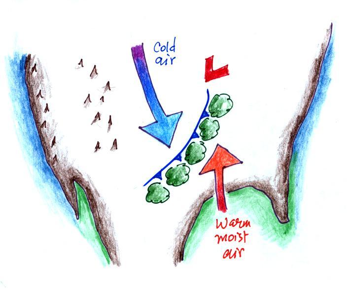
Canada to the Gulf Coast. There it collides with warm moist air
from the Gulf of Mexico to form strong cold fronts and
thunderstorms. There are some other meteorological conditions
that come into play that make these storms capable of producing
tornado
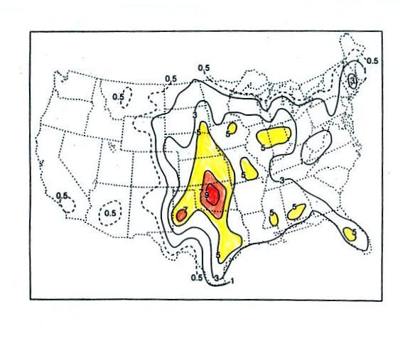
The
following
map (p. 161 in the ClassNotes) wasn't shown in class.
Tornadoes
have
been
observed
in
every
state in the US, but tornadoes are most frequent in the Central
Plains, a region referred to as "Tornado Alley" (highlighted in red,
orange, and yellow above).
Here are some basic
tornado
characteristics (the figure above is also on p. 161)
1. About 2/3rds of tornadoes
are F0 or F1 tornadoes (this is referring to the Fujita Scale, we'll
learn more about the Fujita scale used
to rate
tornado intensity next Tuesday) and have spinning
winds of
about 100 MPH or less. Microburst winds can also reach 100
MPH. Microbursts are much more common in Tucson in the summer
than tornadoes and can inflict
the same level of damage.
2. A very strong inwardly directed pressure
gradient force is needed to keep winds spinning in a circular
path. The pressure in the center core of a tornado can be 100 mb
less than
the pressure in the air outside the tornado. This is a very large
pressure difference in such a short distance. The
PGF
is
much
stronger
than
the
Coriolis
Force
(CF)
and
the
CF
can
be
neglected.
3. Because the Coriolis force doesn't play a
role, tornadoes can spin clockwise or
counterclockwise, though
counterclockwise rotation is more common. This might be because
larger scale motions in the cloud (where the CF is important, might
determine the direction of spin in a tornado).
4, 5, 6. Tornadoes usually last only a few
minutes, leave a path
on the ground that is a few miles
long, and move at a few 10s of MPH. There are exceptions, we'll
look at one shortly.
7, 8. Most tornadoes
move from the SW toward the NE. This is because tornado-producing
thunderstorms are often found just ahead of a cold front where winds
often blow from the SW. Most
tornadoes
have
diameters
of
tens
to
a
few
hundred
yards
but
tornadoes
with
diameters
over
a
mile
have
been
observed.
9, 10. Tornadoes
are
most
frequent
in
the
Spring.
The
strongest
tornadoes
also
occur
at
that
time
of
year.
Tornadoes
are
most
common
in
the
late
afternoon when the atmosphere is most unstable.
A little
more infomation on p. 161 that wasn't mentioned in class.
At the present time about 75 people
are
killed
every year in the
United States by tornadoes. This is about a factor of ten less
than a century
ago due to improved methods of detecting tornadoes and severe
thunderstorms. Modern day communications also make easier to warm
people of dangerous weather situations. Lightning and flash
floods (floods are the most
serious
severe weather hazard) kill slightly more people than tornadoes.
Hurricanes kill
fewer people on average than tornadoes. The increase in the
number of tornadoes observed per year is probably more due to there
being more people in locations that are able to observe and report a
tornado rather than a true increase in tornado activity.
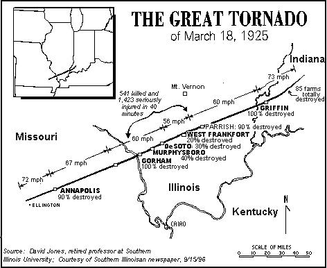
This
figure
traces
out
the
path of the 1925 "Tri-State
Tornado" . The
tornado path (note the SW to NE orientation) was 219 miles long, the
tornado lasted about 3.5 hours and
killed 695 people. The tornado was traveling over 60 MPH over
much of its path. It is still today the deadliest single tornado ever
in the United
States. The Joplin
Missouri tornado (May 22, 2011) killed 162 people making
it the deadliest
since 1947 and the 7th
deadliest tornado in US history.
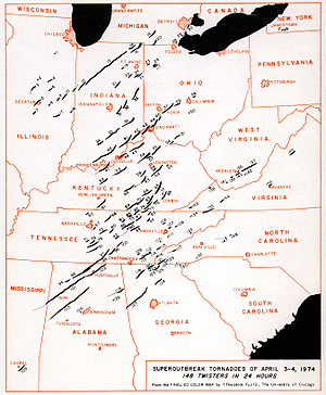
Tornadoes
often
occur
in
"outbreaks."
The
paths
of 148
tornadoes
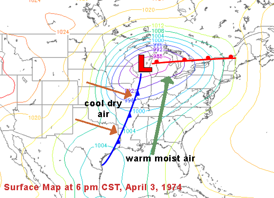
during the April 3-4, 1974 "Jumbo Tornado
Outbreak" are shown above. Note the first tornadoes were
located
in the upper left corner of the map and all of the tornado paths are
oriented from SW to NE. The storm system responsible for the
outbreak is shown below.
The April
25-28,
2011
outbreak is now apparently the largest tornado outbreak
in US history (358 tornadoes, 346 people killed)
As we learn more about tornadoes I'm
hoping you'll look at video with a more critical eye than you would
have otherwise. So we took a moment, at this point, to have
a look at some tornadoes caught on video. If you click on the
links you'll see the same or a similiar video that I found online.
54a
|
F3
|
Grand Isle, NE
|
Mar.
13,
1990
|
tornado
cloud is pretty
thick and vertical |
61f
|
F3
|
McConnell
AFB KS
|
Apr.
26,
1991
|
this
is about as close to a
tornado as you're ever likely to get. Try to judge the diameter
of the tornado cloud. What direction are the tornado winds
spinning?
|
52
|
F5
|
Hesston
KS
|
Mar.
13,
1990
|
Watch
closely,
you may see a tree or two uprooted by the tornado winds
|
51
|
F3
|
North
Platte NE
|
Jun.
25,
1989
|
Trees
uprooted
and buildings lifted by the tornado winds
|
65
|
F1
|
Brainard
MN
|
Jul.
5,
1991
|
It's
a good
thing this was only an F1 tornado
|
57
|
F2
|
Darlington
IN
|
Jun.
1,
1990
|
Tornado
cloud
without much dust
|
62b
|
F2
|
Kansas
Turnpike
|
Apr.
26,
1991
|
It's
sometimes
hard to run away from a tornado. Watch closely you'll see a van
blown off the road and rolled by the tornado. The driver of the
van was killed!
|
47
|
F2
|
Minneapolis
MN
|
Jul.
18,
1986
|
Tornado
cloud
appears and disappears. |
The Kansas
turnpike video also has a warning
that a highway underpass is actually a very dangerous place to take
shelter from a tornado. Here is some additional
information from the Norman OK office of the National Weather
Service. Slide 6 lists some of the reasons why underpasses are so
dangerous.
We looked at one more short video segment with photographs of
supercell thunderstorms and wall clouds. The tape also showed a
computer simulation of the complex motions inside a supercell
thunderstorm. As we'll see next Tuesday thunderstorms with
rotating updrafts (mesocyclones) and supercells produce a unique
signature on radar called a hook echo. We'll also look at
the Fujita Scale used to rate
tornado strength and intensity and look at some of the kinds of damage
that tornadoes can produce.