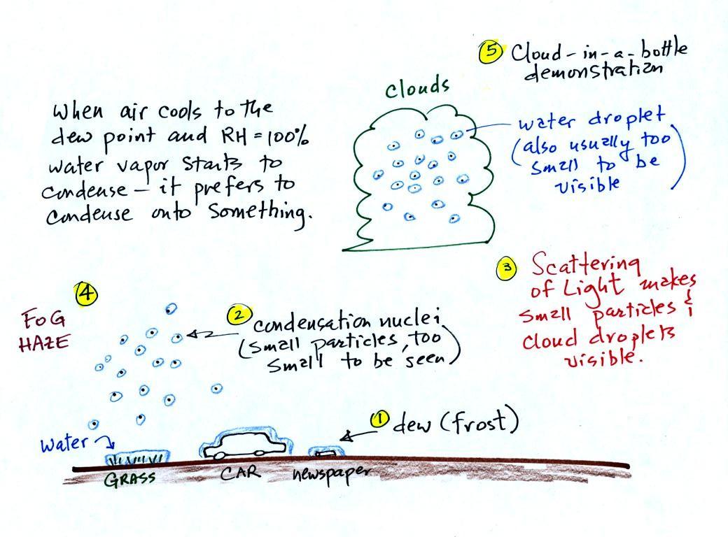
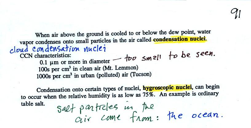
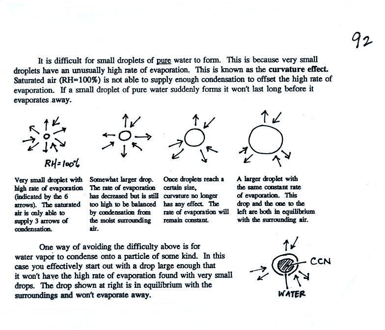
Tuesday Oct. 23, 2012

We had a visitor in the MWF class yesterday from Peru so I thought some music from the Andes might be appropriate.  You heard "Tierra de Vicunas" and "Ocaso" from a group named Sukay.  Turns out they're from Bolivia not Peru and I wasn't able to find them on YouTube.

It's a few days early, but the Quiz #3 Study Guide is now online.  Note the change in the location of the Tuesday 4-5 pm review.

The Experiment #3 reports are due next Tuesday.  You should try to return the materials this week so that you can pick up a copy of the Supplementary Information handout.

A couple of In-class Optional Assignments on Energy Balance and Humidity Variables were returned today.  A new, fairly challenging, humidity Optional Assignment was handed out.  You had the option of turning it in at the end of class or waiting until Thursday to turn it in.  There is also a Humidity Problems Optional Assignment due on Thursday.


We had a couple of humidity example problems from last week to finish up.

Example 3


You're given the the mixing ratio = 10.5 g/kg and the relative humidity = 50%.   
You need to figure out the air temperature and the dew point temperature.  Here's the play by play solution to the question

(1) The air contains 10.5 g/kg of water vapor, this is 50%, half, of what the air could potentially hold.  So the air's capacity, the saturation mixing ratio must be 21 g/kg (you can either do this in your head or use the RH equation following the steps shown above). 

(2) Once you know the saturation mixing ratio you can look up the air temperature in a table (80 F air has a saturation mixing ratio of 21 g/kg)

(3) Then you imagine cooling the air until the RH becomes 100%.  This occurs at 60 F.  The dew point is 60 F.


Example 4
Probably the most difficult problem of the bunch. 

But one of the things we said about dew point is that it has the same job as mixing ratio - it gives you an idea of the actual amount of water vapor in the air.  This problem will show that if you know the dew point, you can quickly figure out the mixing ratio.  Knowing the dew point is equivalent to knowing the mixing ratio.


Here's what we ended up with in class, we were given the air temperature and the dew point temperature.  We were supposed to figure out the mixing ratio and the relative humidity. 


We enter the two temperatures onto a chart and look up the saturation mixing ratio for each.


We ignore the fact that we don't know the mixing ratio.  We do know that if we cool the 90 F air to 50 F the RH will become 100%.  We can set the mixing ratio equal to the value of the saturation mixing ratio at 50 F, 7.5 g/kg.


Remember back to the three earlier examples.  When we cooled air to the the dew point, the mixing ratio didn't change.  So the mixing ratio must have been 7.5 all along.   Once we know the mixing ratio in the 90 F air it is a simple matter to calculate the relative humidity, 25%.


Next just like you occasionally need to eat up a bunch of leftovers in your refrigerator.  In Atmo 170 we sometimes need to tie up a bunch of loose ends.

The figure below is on p. 87 in the photocopied ClassNotes.  It explains how you can dry moist air.


At Point 1 we start with some 90 F air with a relative humidity of 25%, fairly dry air.   These are the same numbers in Example Problem #4 last Wednesday.  We imagine cooling this air to the dew point temperature, 50 F, where the relative humidity would reach 100% and a cloud would form (Pt. 2 in the figure above). 

Then we continue to cool the air below the dew point, to 30 F.  Air that is cooled below the dew point finds itself with more water vapor than it can contain.  The excess moisture must condense (we will assume it falls out of the air as rain or snow).  When air reaches 30 F it contains 3 g/kg, less than half the moisture that it originally did (7.5 g/kg).  The air is being warmed back up to 90 F along Path 4.  As it warms the mixing ratio remains constant.  At Point 5, the air now has a RH of only 10%.

Drying moist air is very much like wringing moisture from a wet sponge.


You start to squeeze the sponge and it gets smaller.  That's like cooling the air and reducing the saturation mixing ratio, the air's capacity for water vapor.  At first squeezing the sponge doesn't cause anything to happen (that's like cooling the air, the mixing ratio stays constant as long as the air doesn't lose any water vapor).  Eventually water will start to drop from the sponge (with air this is what happens when you reach the dew point and continue to cool the air below the dew point).  Then you let go of the sponge and let it expand back to its orignal shape and size (the air warms back to its original temperature).  The sponge (and the air) will be drier than when you started.

This sort of process ("squeezing" water vapor out of moist air by cooling the air below its dew point) happens all the time.  Here are a couple of examples (p. 87 again)


In the winter cold air is brought inside your house or apartment and warmed.  Imagine 30 F air with a RH of 100% (this is a best case scenario, the cold air outdoors usually has a lower dew point and is drier). Bringing the air inside and warming it will cause the RH to drop from 100% to 20%..  Air indoors during the winter is often very dry.  This can cause chapped skin, can irritate nasal passages, and cause cat's fur to become charged with static electricity.

The air in an airplane comes from outside the plane.  The air outside the plane can be very cold (-60 F perhaps) and contains very little water vapor (even if the -60 F air is saturated it would contain essentially no water vapor).  When brought inside and  warmed to a comfortable temperature, the RH of the air in the plane will be very close 0%.  Passengers often complain of dehydration on long airplane flights.  The plane's ventilation system must add moisture to the air so that it doesn't get that dry.


Next a much more important example of drying moist air (see p. 88 in the photocopied ClassNotes).


We start with some moist but unsaturated air (the RH is about 50%) at Point 1 (the air and dew point temperatures would need to be equal in order for the air to be saturated).  As it is moving toward the right the air runs into a mountain and starts to rise.  Rising air expands and cools.   Unsaturated air cools 10 C for every kilometer of altitude gain.  This is known as the dry adiabatic lapse rate and isn't something you need to remember.  So after rising 1 km the air will cool to 10 C which is the dew point.

The air becomes saturated at Point 2 (the air temperature and the dew point are both 10 C).  Would you be able to tell if you were outdoors looking at the mountain?  Yes, you would see a cloud appear. 

Now that the RH = 100%, the saturated air cools at a slower rate than unsaturated air (condensation of water vapor releases latent heat energy inside the rising volume of air, this warming partly offsets the cooling caused by expansion).  We'll use a value of 6 C/km (an average value).  The air cools from 10 C to 4 C in next kilometer up to the top of the mountain.  Because the air is being cooled below its dew point at Point 3, some of the water vapor will condense and fall to the ground as rain.  Moisture is being removed from the air and the value of the mixing ratio (and the dew point temperature) decreases.

At Point 4 the air starts back down the right side of the mountain.  Sinking air is compressed and warms.  As soon as the air starts to sink and warm, the relative humidity drops below 100% and the cloud disappears.  The sinking unsaturated air will warm at the 10 C/km rate. 

At Point 5 the air ends up warmer (24 C vs 20 C) and drier (Td = 4 C vs Td = 10 C) than when it started out.  The downwind side of the mountain is referred to as a "rain shadow" because rain is less likely there than on the upwind side of the mountain.  Rain is less likely because the air is sinking and because the air on the downwind side is drier than it was on the upslope side.


We can see the effects of a rainshadow illustrated well in the state of Oregon.  The figure above at left shows the topography (here's the source of that map).  Winds generally blow from west to east across the state. 

Coming off the Pacific Ocean the winds first encounter a coastal range of moutains.  On the precipitation map above at right (source) you see a lot of greens and blue on the western sides of the coastal range.  These colors indicate yearly rainfall totals that range from about 50 to more than 180 inches of rain per year.  temperate rainforests are found in some of these coastal locations.

That's the Willamette River, I think, in between the coastal range and the Cascades.  This valley is somewhat drier than the coast because air moving off the Pacific has lost some of its moisture moving over the coastal range. 

What moisture does remain in the air is removed as the winds move up and over the taller Cascades.  Yearly rainfall is generally less than 20 inches per year on the eastern side, the rainshadow side, of the Cascades.  That's not too much more than Tucson which averages about 12 inches of rain a year.

Most of the year the air that arrives in Arizona comes from the west, from the Pacific Ocean (this changes in the summer).  It usually isn't very moist by the time it reaches Arizona because it has travelled up and over the Sierra Nevada mountains in California and the Sierra Madre mountains further south in Mexico.  The air loses much of its moisture on the western slopes of those mountains. 


A variety of things can happen when you cool air to the dew point and the relative humidity increases to 100%.  Point 1 shows that when moist air next to the ground is cooled to and below the dew point, water vapor condenses onto (or is deposited onto) the ground or objects on the ground.  This forms dew, frozen dew, and frost. 

Air above the ground can also be cooled to the dew point.  When that happens (Point 2 above) it is much easier for water vapor to condense onto something rather than just forming a small droplet of pure water.    In air above the ground water vapor condenses onto small particles in the air called condensation nuclei.  Both the condensation nuclei and the small water droplets that form on them are usually too small to be seen with the naked eye.  We can tell they are present (Point 3) because they either scatter (haze or fog) or reflect (clouds) sunlight. 

We'll look at condensation nuclei and the role they play in cloud formation later today.


The somewhat confusing figures on p. 90 try to explain the difference in the formation of dew, frozen dew, and frost.


It might be a little hard to figure out what is being illustrated here.  Point 1 is sometime in the early evening when the temperature of the air at ground level is 65.  During the course of the coming night the air will cool to 35 F.  When the air temperature reaches 40 F, the dew point, the relative humidity reaches 100% and water vapor begins to condense onto the ground.  You would find your newspaper and your car covered with dew (water) the next morning.


The next night is similar except that the nighttime minimum temperature drops below freezing.  Dew first forms (condensation) and covers everything on the ground with water.  Then the water freezes and turns to ice.  This isn't frost, rather frozen dew.  Frozen dew is often thicker and harder to scrape off your car windshield than frost. 

Now the dew point and the nighttime minimum temperature are both below freezing.  When the RH reaches 100% water vapor turns directly to ice (deposition).  This is how frost forms.

What happens on this night?  Because the nighttime minimum temperature never reaches the dew point and the RH never reaches 100%, nothing would happen.  I've seen some textbooks refer to this as black frost but I don't like to use that term.  You have probably heard of black ice.  Black ice does sometimes form on road surfaces and is a very dangerous driving hazard.  Because it's hard to see you can hit it with your car and lose control. 

Here's another way of visualizing the difference between dew, frost, and frozen dew.


When the relative humidity in air above the ground (and away from objects on the ground) reaches 100%, water vapor will condense onto small particles called condensation nuclei.  It would be much harder for the water vapor to just condense and form small droplets of pure water (you can learn why that is so by reading the top of p. 92 in the photocopied class notes).  There are always lots of CCN (cloud condensation nuclei in the air) so this isn't an impediment to cloud formation.


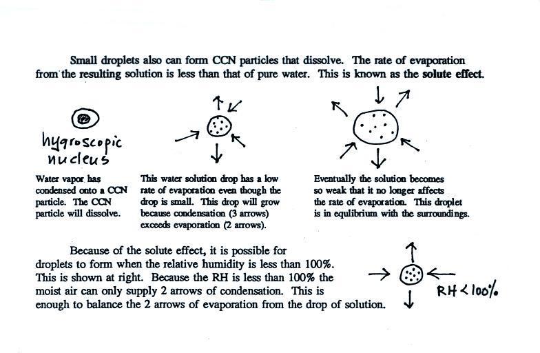
Water vapor will condense onto certain kinds of condensation nuclei even when the relative humidity is below 100% (again you will find some explanation of this on the bottom of p. 92).  These are called hygroscopic nuclei.  Salt is an example; small particles of salt mostly come from evaporating drops of ocean water.


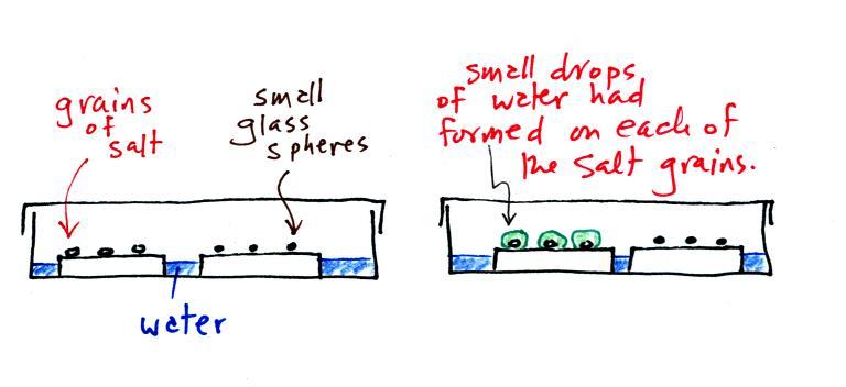
A short homemade video (my first actually) that showed how water vapor would, over time, preferentially condense onto small grains of salt rather than small spheres of glass.  The figure below wasn't shown in class.


The start of the video at left showed the small grains of salt were placed on a platform in a petri dish containing water.  Some small spheres of glass were placed in the same dish.  After about 1 hour small drops of water had formed around each of the grains of salt but not the glass grains (shown above at right).

In humid parts of the US, water will condense onto the grains of salt in a salt shaker causing them to stick together.  Grains of rice apparently absorb moisture which keeps this from happening and also break up lumps of salt once they start to form.  Grains of rice might also be used because they won't fall out of the holes in the salt shaker together with the salt.  You'll find this discussed in an interesting Wikipedia article about salt.


The following figure is at the bottom of p. 91 in the ClassNotes.
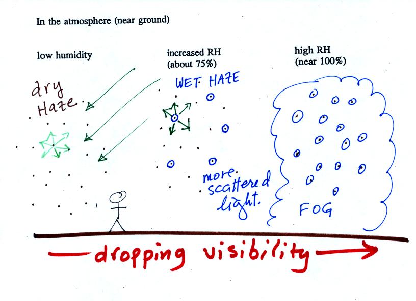


This figure shows how cloud condensation nuclei and increasing relative humidity can affect the appearance of the sky and the visibility.

The air in the left most figure is relatively dry.  Even though the condensation nuclei particles are too small to be seen with the human eye you can tell they are there because they scatter sunlight.  When you look at the sky you see the deep blue color caused by scattering of sunlight by air molecules mixed together with some white sunlight scattered by the condensation nuclei.  This changes the color of the sky from a deep blue to a bluish white color.  The more particles there are the whiter the sky becomes.  This is called "dry haze."  Visibility under these conditions might be a few tens of miles.

The middle picture shows what happens when you drive from the dry southwestern part of the US into the humid southeastern US or the Gulf Coast.  One of the first things you would notice is the hazier appearance of the air and a decrease in visibility.  Because the relative humidity is high, water vapor begins to condense onto some of the condensation nuclei particles (the hygroscopic nuclei) in the air and forms small water droplets.  The water droplets scatter more sunlight than just small particles alone.  The increase in the amount of scattered light is what gives the air its hazier appearance. This is called "wet haze."  Visibility now might now only be a few miles.

Finally when the relative humidity increases to 100% fog forms.  Fog can cause a severe drop in the visibility.  The thickest fog forms in dirty air that contains lots of condensation nuclei.  That is part of the reason the Great London Smog of 1952 was so impressive.  Visibility was at times just a few feet!  We 
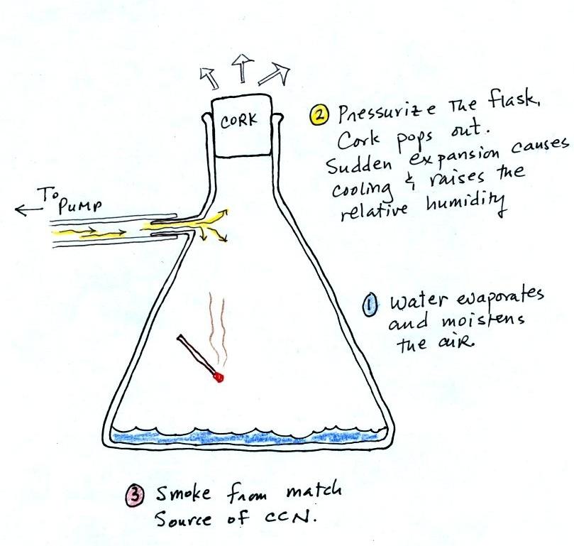
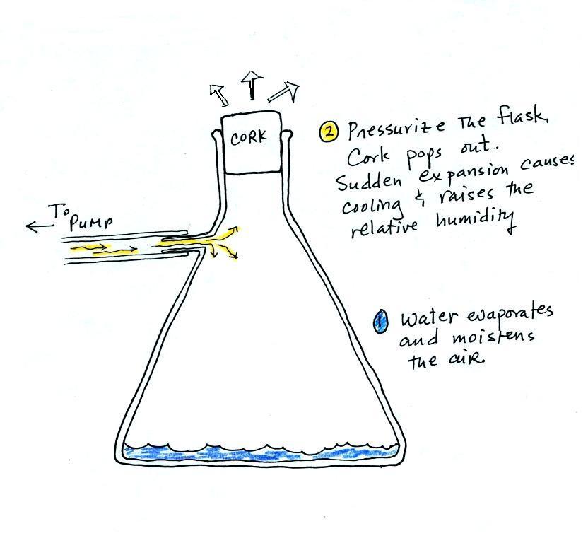
could see this effect in the cloud-in-a-bottle demonstration that was performed next.

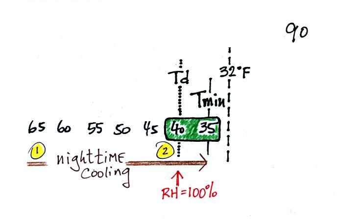
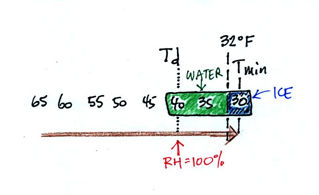
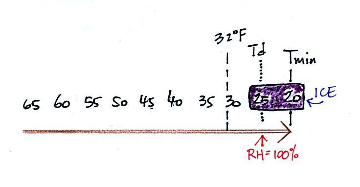
Cooling air, changing relative humidity, condensation nuclei, and scattering of light are all involved in this demonstration.


We used my backup flask in class.  Normally I use use a strong, thick-walled, 4 liter vacuum flask (designed to not implode when all of the air is pumped out of them, they aren't designed to not explode when pressurized).  There was a little water in the bottom of the flask to moisten the air in the flask.  Next we pressurized the air in the flask with a bicycle pump.  At some point the pressure blows the cork out of the top of the flask.  The air in the flask expands outward and cools.  This sudden cooling increases the relative humidity of the moist air in the flask to 100% ( probably more than 100% momentarily ) and water vapor condenses onto cloud condensation nuclei in the air.  A very faint cloud became visible at this point. 


The demonstration was repeated an additional time with one small change.  A burning match was dropped into the bottle.  The smoke from the matches added lots of very small particles, condensation nuclei, to the air in the flask.  The same amount of water vapor was available for cloud formation but the cloud that formed this time was quite a bit "thicker" and much easier to see.  To be honest the burning match probably also added a little water vapor (water vapor together with carbon dioxide is one of the by products of combustion).

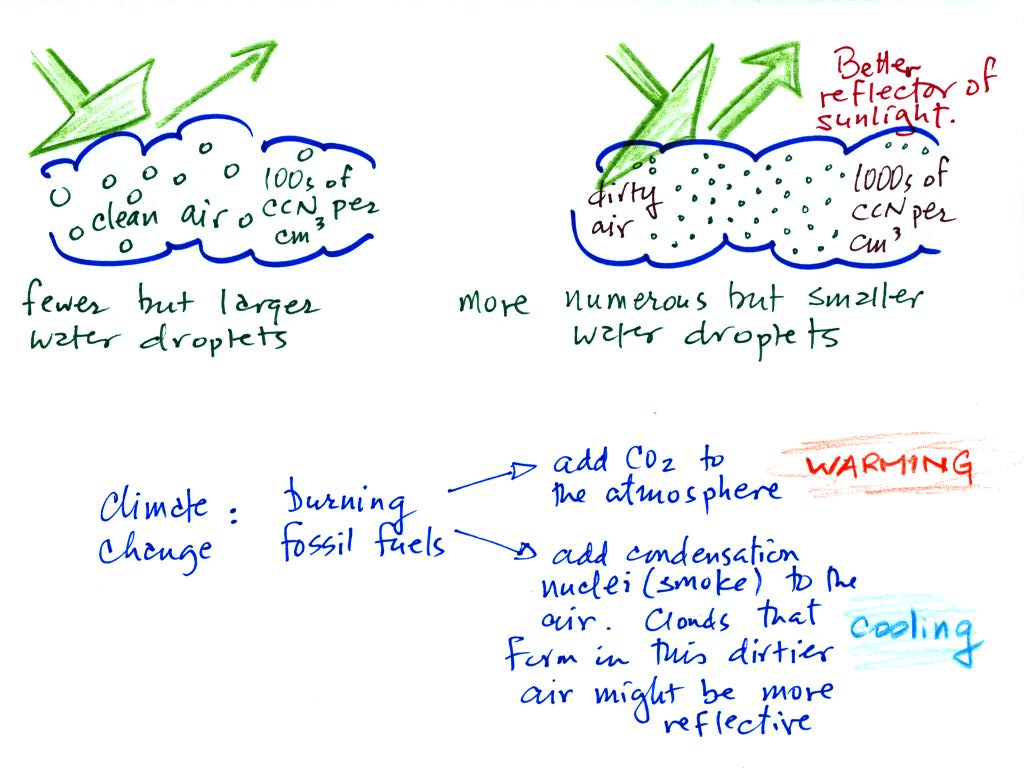
This effect has some implications for climate change.


A cloud that forms in dirty air is composed of a large number of small droplets (right figure above).  This cloud is more reflective than a cloud that forms in clean air, that is composed of a smaller number of larger droplets (left figure).  

Combustion of fossil fuels adds carbon dioxide to the atmosphere.  There is concern that increasing carbon dioxide concentrations (and other greenhouse gases) will enhance the greenhouse effect and cause global warming.  Combustion also adds condensation nuclei to the atmosphere (just like the burning match added smoke to the air in the flask).  More condensation nuclei might make it easier for clouds to form, might make the clouds more reflective, and might cause cooling.  There is still quite a bit of uncertainty about how clouds might change and how this might affect climate.  Remember that clouds are good absorbers of IR radiation and also emit IR radiation.


Clouds are one of the best ways of cleaning the atmosphere


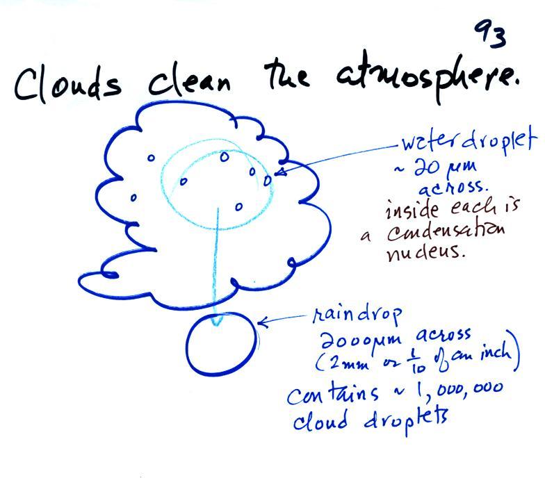
A cloud is composed of small water droplets (diameters of 10 or 20 micrometers) that form on particles ( diameters of perhaps 0.1 or 0.2 micrometers). The droplets "clump" together to form a raindrop (diameters of 1000 or 2000 micrometers which is 1 or 2 millimeters), and the raindrop carries the particles to the ground.  A typical raindrop can contain 1 million cloud droplets so a single raindrop can remove a lot of particles from the air.  You may have noticed how clear the air seems the day after a rainstorm; distant mountains are crystal clear and the sky has a deep blue color.  Gaseous pollutants can dissolve in the water droplets and be carried to the ground by rainfall also.  We'll be looking at the formation of precipitation later this week.