Last, before we leave the topic of clouds and precipitation, some information about satellite photographs of clouds.

Satellites are able to detect and photograph both the visible light reflected by clouds (that's what we would see if we were in space looking down at the earth) and the infrared radiation emitted by clouds (clouds are visible 24 hours a day)


IR satellite photographs


When you see satellite photographs of clouds on the TV weather you are probably seeing an infrared satellite photograph.

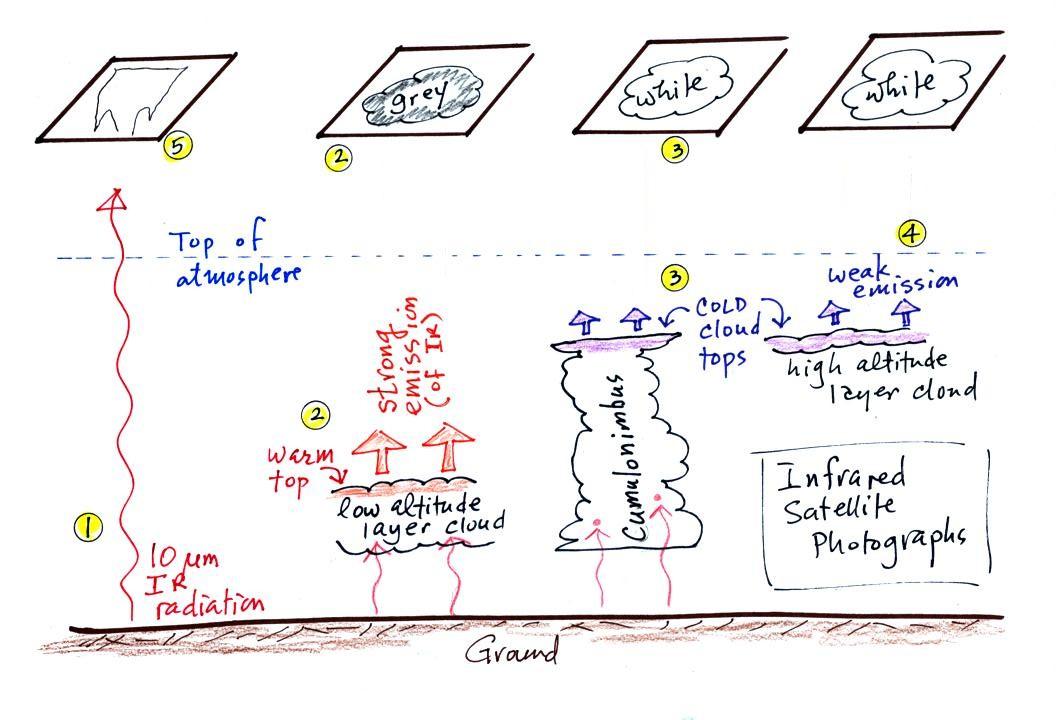
1. An infrared satellite photograph detects the 10 μm IR radiation actually emitted by the ground, the ocean and by clouds.  You don't depend on seeing reflected sunlight, so  clouds can be photographed during the day and at night, 24 hours per day.  You may recall that 10 μm radiation is in the middle of the atmospheric window, so this radiation is able to pass through air without being absorbed.  If clouds don't get in the way, you can see the ground and the ocean on an IR photograph.

2.   Clouds do absorb 10 μm radiation and then reemit 10 μm IR radiation upwards toward the satellite and down toward the ground.  It is the radiation emitted by the top surface of the cloud that will travel through the atmosphere and up to the satellite.  The top surface of a low altitude cloud will be relatively warm.  Warmer objects emit stronger IR radiation than a cool object (the Stefan Boltzmann law).  This is shown as grey on an IR satellite photograph.  A grey unimpressive looking cloud on an IR satellite photograph may actually be a thick nimbostratus cloud that is producing rain or snow.

3.   Cloud tops found at high altitude are cold and emit IR radiation at a lower rate or lower intensity.  This shows up white on an IR photograph. 

4.   Two very different clouds (a thunderstorm and a cirrostratus cloud) would both appear white on the satellite photograph and would be difficult to distinguish.  Meteorologists are interested in locating thunderstorms because they can produce hazardous severe weather.  This can't be done using just IR photographs. 

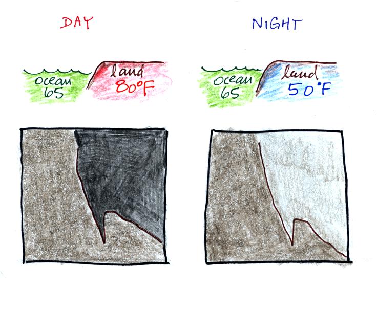
5.   And here is what I think is one of the most interesting things you can see on an IR satellite photograph, it doesn't have anything to do with clouds.  The ground changes temperature during the course of the day.  On an infrared satellite animation you can watch the ground change from dark grey or black (afternoon when the ground is warmest) to lighter grey (early morning when the ground is cold) during the course of a day.  Because of water's high specific heat, the ocean right alongside doesn't change temperature much during the day and remains the same shade of grey throughout the day. 


Here's a link to an IR satellite photograph loop on the UA Atmospheric Sciences Dept. webpage.  Watch the ground change from light grey to dark grey.  By comparison the ocean's shade of grey doesn't appear to change at all.

24 hours of IR satellite photography (National Weather Service)


Visible satellite photographs


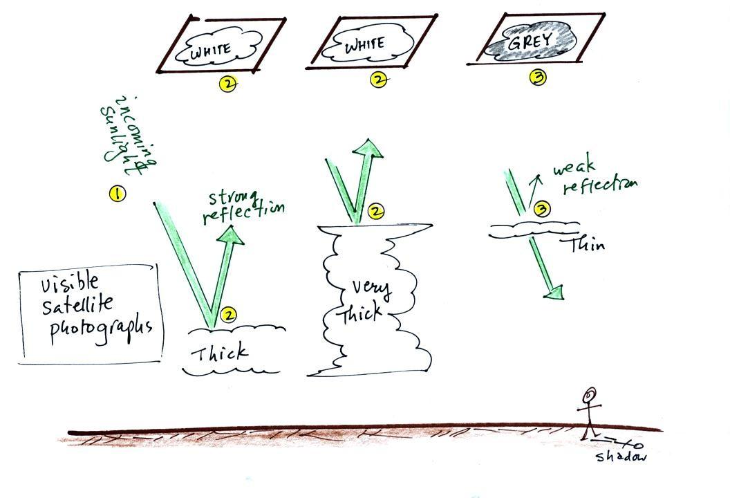
1. A visible satellite photograph photographs sunlight that is reflected by clouds.  It shows what you would see if you were out in space looking down at the earth.  You won't see clouds on a visible satellite photograph at night. 

2. Thick clouds are good reflectors and appear white. 
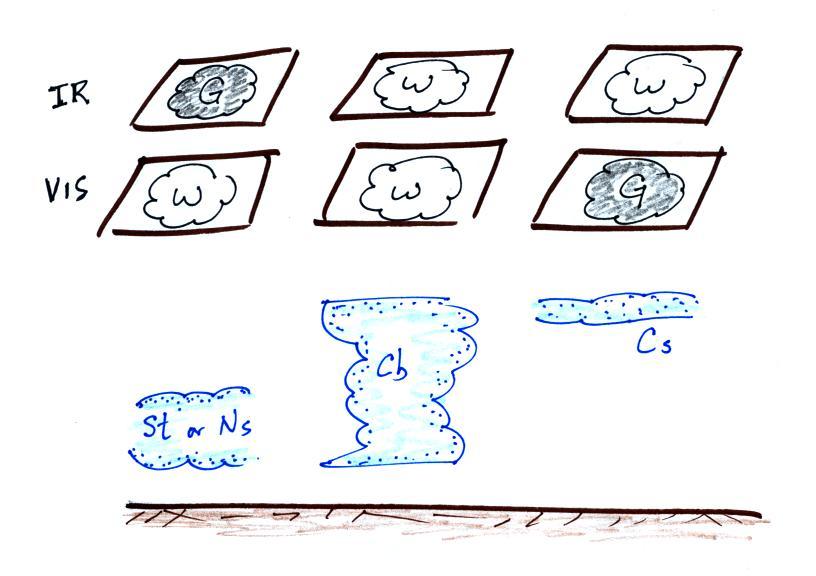
The low altitude layer cloud and the thunderstorm would both appear white on this photograph and would be difficult to distinguish.

3. Thinner clouds don't reflect as much light and appear grey. 


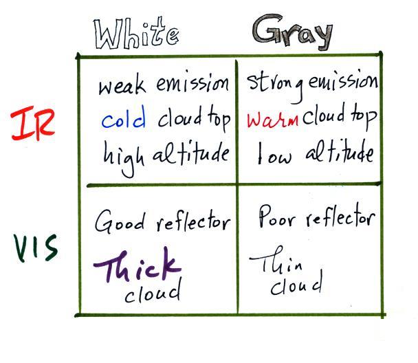
Here's a summary


The figure below shows how if you combine both visible and IR photographs you can begin to distinguish between different types of clouds.


You can use this figure to answer the satellite photograph question that is on the Quiz #3 Study Guide.