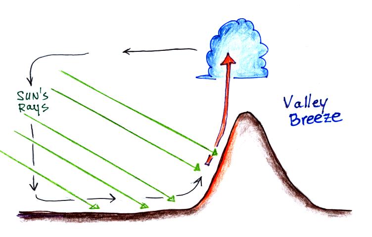
This first figure shows
development
of a valley breeze. This is a circulation that forms
early in the
day when the sun's rays are striking the mountain sides more
directly
than the level ground in the valley. The mountain sides
will
begin to warm more rapidly that the valley floor (the mountain
slopes
aren't warmer than the valley just warming more quickly
because the
incident sunlight is more direct). Air in contact with
the
mountain warms and becomes buoyant and creates an upslope
breeze.
Wind begins to blow from the valley up the mountain sides to
replace
the rising air. Note that clouds can form if the rising
air is moist enough.
At night the ground will cool more quickly and becomes colder than the air above.
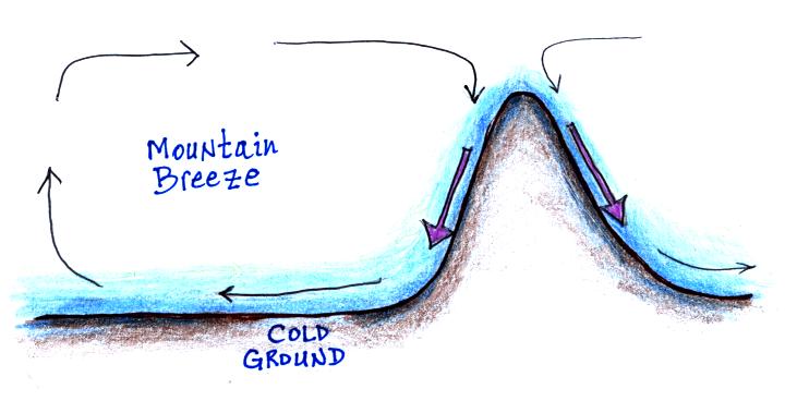
At night the ground will cool more quickly and becomes colder than the air above.

Air in contact with the
ground
cools. This now denser air slides down the mountain
sides and moves into the
valleys. Since the surface winds blow from the
mountain into the
valleys this is called a mountain breeze.
The term katabatic wind is a more general term for a high density, gravity driven, down slope or drainage wind. A katabatic wind can affect a much larger area than a simple mountain breeze.
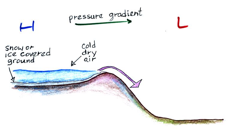
Katabatic winds often originate over high elevation
snow covered
plateaus where stagnant air can become quite cold and also
very
dry. A large scale pressure pattern can then move
the air away
from its source region. When the downward moving air
is confined
by canyon walls, winds can reach hurricane force.
Though
generally cold, katabatic winds can also be warm or
hot. This is
because as the air moves downhill and is compressed it
warms (the katabatic wind would start out cold but become
warmer as it moves downhill).
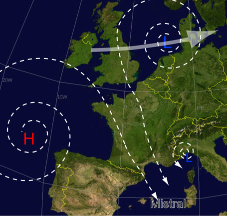
The mistral is a strong, cold, dry, katabatic wind that affects SE France. In this case the downward flow of the air is enhanced by a large scale pressure pattern. The winds spinning clockwise around the high and counterclockwise around the low combine to blow across France in the left figure above. These winds can persist for several days. (these two figures are from a Wikipedia article on the mistral)
A chinook (foehn) wind is a warm dry down slope wind. The figure below is much like the one used to explain the rain shadow effect earlier in the semester. Air flowing up and over a mountain is cooled to and then below the dew point. Moisture in the air condenses and releases latent heat into the rising air on the left side of the mountain. Once the air reaches the summit and starts to descend it is compressed. This causes additional warming.
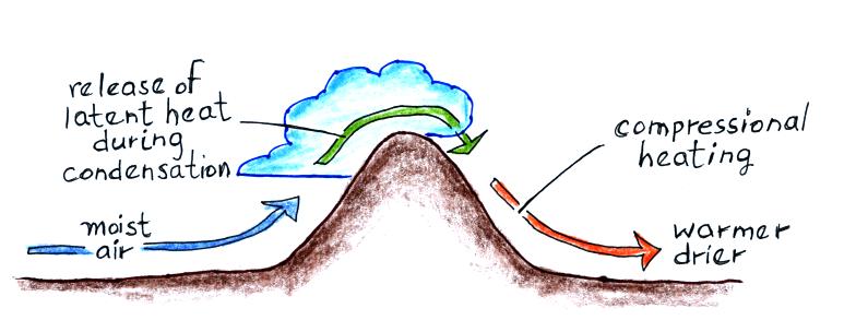
The air ends up warmer and drier than it was originally.
The arrival of a chinook wind in winter can produce record setting changes in weather and temperature (these records are from a Wikipedia article on Chinook winds)
In both situations above, the air was originally very cold. The arrival of the chinook wind caused very rapid warming.
The Santa Ana winds are probably the best known of the regional winds we will be discussing. These are warm (hot) dry winds that originate in the high deserts of the Great Basin and blow southwestward across southern California usually in the fall. They are often associated with devastating wild fires.

The wind circulation that develops when high pressure forms over the Great Basin causes some of the cool (cold) dense air to begin to move downhill toward the coast. As the air descends it is compressed and warms (this is the main source of warming). Winds pick up speed when the air is funneled through mountain canyons near the coast. There is often a marked improvement in visibility in the Los Angeles basin when the Santa Ana winds are blowing because they blow pollutants out to sea (assuming of course there isn't any smoke in the air due to wildfire activity).
As mentioned earlier the Santa Ana winds can quickly turn a relatively small wildfire into a catastrophic fire event. 9 people were killed, 85 injured, at least 1500 homes and 500,000 acres were burned during a series of wildfires in Southern California in October, 2007. Drought and the Santa Ana winds were major contributing factors.
In addition to being a fire danger, winds in desert regions like southeastern Arizona can produce dust storms.

This is a particularly good photograph of a dust storm approaching a military camp in Al Asad, Iraq. The picture was taken just before nightfall on April 27, 2005 by Corporal Alicia M. Garcia (US Marine Corp.). Dust or sand storms like this are often called a haboob.
Dust storms are a particular hazard to highway travel because they can reduce visibility to near zero very rapidly.

This photograph, taken in August 2003, shows a dust cloud moving into the Pheonix area (Ahwatukee) in August, 2003. The dust probably marks the leading edge of cold downdraft winds that are moving outward from underneath a thunderstorm (the gust front).
Here are some suggestions about what you should do if you are caught in a dust storm.
The term katabatic wind is a more general term for a high density, gravity driven, down slope or drainage wind. A katabatic wind can affect a much larger area than a simple mountain breeze.

 |
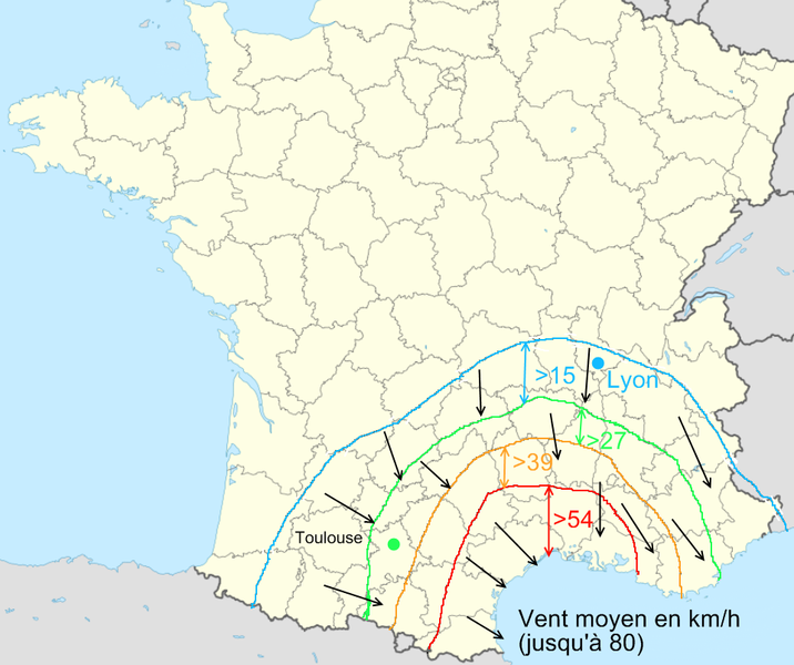 |
The mistral is a strong, cold, dry, katabatic wind that affects SE France. In this case the downward flow of the air is enhanced by a large scale pressure pattern. The winds spinning clockwise around the high and counterclockwise around the low combine to blow across France in the left figure above. These winds can persist for several days. (these two figures are from a Wikipedia article on the mistral)
A chinook (foehn) wind is a warm dry down slope wind. The figure below is much like the one used to explain the rain shadow effect earlier in the semester. Air flowing up and over a mountain is cooled to and then below the dew point. Moisture in the air condenses and releases latent heat into the rising air on the left side of the mountain. Once the air reaches the summit and starts to descend it is compressed. This causes additional warming.

The air ends up warmer and drier than it was originally.
The arrival of a chinook wind in winter can produce record setting changes in weather and temperature (these records are from a Wikipedia article on Chinook winds)
| Greatest
temperature
change in a 24 hour period |
Most
rapid
temperature change ever recorded |
|
103 F change
(-54 F to +49 F) Jan. 1972,
Loma, Montana
|
49
F in
2 minutes (-4 F to +45 F) Spearfish, South Dakota |
In both situations above, the air was originally very cold. The arrival of the chinook wind caused very rapid warming.
The Santa Ana winds are probably the best known of the regional winds we will be discussing. These are warm (hot) dry winds that originate in the high deserts of the Great Basin and blow southwestward across southern California usually in the fall. They are often associated with devastating wild fires.

The wind circulation that develops when high pressure forms over the Great Basin causes some of the cool (cold) dense air to begin to move downhill toward the coast. As the air descends it is compressed and warms (this is the main source of warming). Winds pick up speed when the air is funneled through mountain canyons near the coast. There is often a marked improvement in visibility in the Los Angeles basin when the Santa Ana winds are blowing because they blow pollutants out to sea (assuming of course there isn't any smoke in the air due to wildfire activity).
As mentioned earlier the Santa Ana winds can quickly turn a relatively small wildfire into a catastrophic fire event. 9 people were killed, 85 injured, at least 1500 homes and 500,000 acres were burned during a series of wildfires in Southern California in October, 2007. Drought and the Santa Ana winds were major contributing factors.
In addition to being a fire danger, winds in desert regions like southeastern Arizona can produce dust storms.

This is a particularly good photograph of a dust storm approaching a military camp in Al Asad, Iraq. The picture was taken just before nightfall on April 27, 2005 by Corporal Alicia M. Garcia (US Marine Corp.). Dust or sand storms like this are often called a haboob.
Dust storms are a particular hazard to highway travel because they can reduce visibility to near zero very rapidly.

This photograph, taken in August 2003, shows a dust cloud moving into the Pheonix area (Ahwatukee) in August, 2003. The dust probably marks the leading edge of cold downdraft winds that are moving outward from underneath a thunderstorm (the gust front).
Here are some suggestions about what you should do if you are caught in a dust storm.