I said something incorrect in class on Thursday about Question 4 in the Short Answer section from the old exam. The questions says:
Shown above is a portion of a sea level weather map. Based on the pattern of isobars, draw arrows at points A and B showing the wind direction. Does the wind pattern you drew result in divergence, convergence, or neither for the region located between points A and B? Will this force air to rise, to sink, or neither in a vertical air column located between points A and B?
Right at the end of class I said that there is no convergence for this situation. What I said was incorrect!! There IS convergence as I try to explain below.
In the figures below
Black lines are isobars (lines of constant pressure) at sea level
Blue arrows represent the Pressure Gradient Force (PGF) directed from high pressure to low pressure
Green arrows represent the Coriolis force (directed to the right of the wind in the Northern Hemisphere)
Gray arrows represent the friction force (directed opposite to the wind direction)
Red dotted arrows represent the wind speed and direction
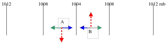
We start with Geostrophic Balance where the PGF and Coriolis force are equal and opposite so their sum is 0. This balance is approximately true above 1- 2 km altitude above the surface and at least 20 degrees of latitude away from the equator. (Remember at the equator the Coriolis force goes to zero). The figure below shows the PGF and Coriolis forces and the wind. In the absence of surface FRICTION, the winds do NOT converge toward the lower pressure region.
NOW add friction…
Now we add friction due to the wind near the surface being slowed down by friction as it blows across the surface. The force balance is now PGF + Coriolis force + Frictional force and the sum of these 3 forces is approximately 0. Friction occurs near the surface (“near” means within 1 or 2 km of the surface).
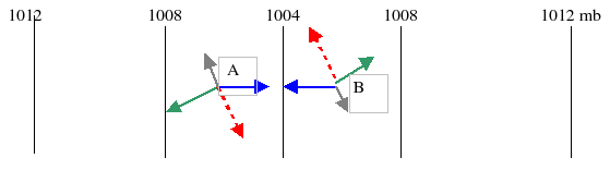
Note that because of the friction, the wind (the red arrows) has now turned somewhat toward the low pressure region (the 1004 mb line) at the center. As a result, there IS some convergence near the surface because the winds on both sides of the low pressure have a component directed toward the low pressure region along the center of the figure. This convergence will cause the air to rise as it approaches the 1004 mb line (because it has nowhere else to go but up).
Force balance with friction: Notice that if you put the Coriolis force, frictional force and PGF all end to end you end up where you started which means the 3 forces sum to zero (approximately).
The key point here is that friction causes the winds near the surface to turn a bit toward the region of low pressure (and away from the region of high pressure).
As result, near the surface, there is convergence into low pressure regions causing air to rise above surface low pressure regions. The rising motion
This is why bad or rainy weather is associated with surface low pressure systems
For the same reasons, there will be low level divergence from surface high pressure regions causing air to sink above regions of high surface pressure. The sinking motion
So regions of sinking motion are hot and dry and regions that are like this most of the time are deserts like where we live in Arizona.