Wednesday Apr. 11, 2007
Today was the 1st of the 1S1P Assignment #3 due dates (you could turn
in one or two reports today). The 2nd due date is next Wed., Apr.
18. You can only turn in one report on the 2nd due date.
You can't do more than two reports as part of Assignment #3.
One of the
reasons for studying the Coriolis force was the question about water
draining from sinks in the southern hemisphere. The suggestion is
that because the winds that spin around centers of high and low
pressure change direction in the northern and southern hemisphere, the
direction of the spinning motion of water draining from a sink or
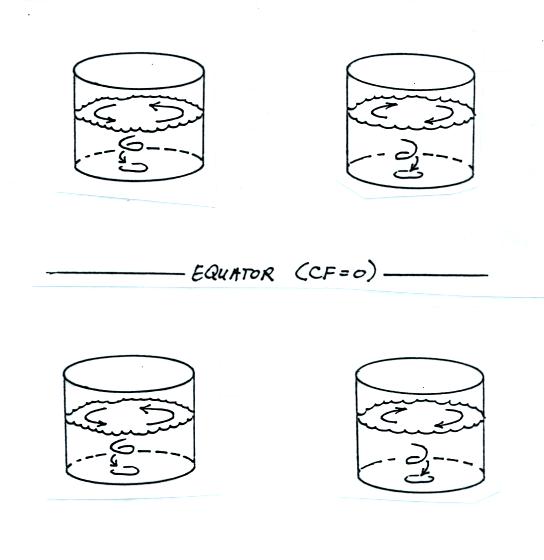
toilet bowl will also change direction. This is not the
case. Draining water can spin in either direction in either
hemisphere and at the equator where the Coriolis force is zero.
This is discussed on p. 130 in the photocopied Class Notes.
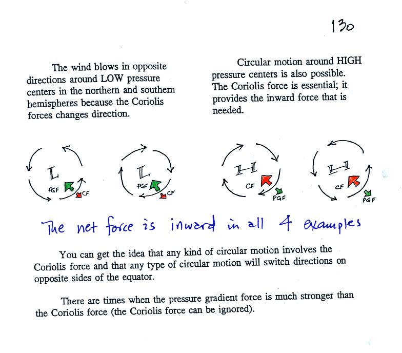
Spinning winds do change directions around large high and low pressure
centers. The PGF starts the air moving (in toward low, out and
away from high pressure) then the Coriolis force bends the wind to the
right (N. hemisphere) or to the left (S. hemisphere).
There are situations where the PGF is much stronger than the CF and the
CF can be ignored.
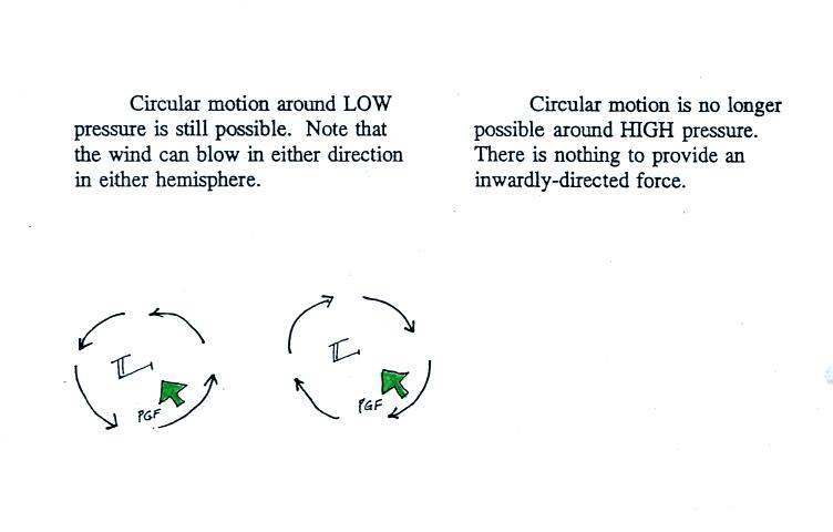
In this case spinning motion is only possible around low pressure.
Water can spin in either direction and drain from a bucket in the N.
hemisphere, at the Equator itself, and in the S. hemisphere (despite
what the short demonstration on the video shown in class seemed to
show).
What provides the necessary inwardly directed force needed to keep
water spinning and draining from a bucket or sink (here we go "beating
a topic to death" again)? The answer is shown in the figure below.
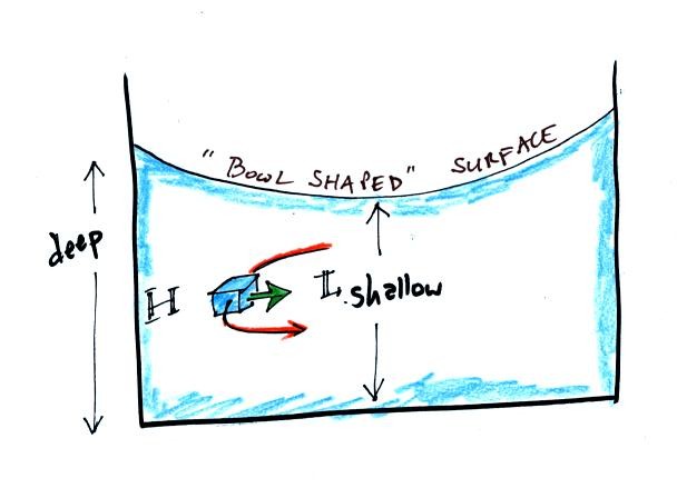
If you look closely at water spinning in a bucket or sink you will
notice that the surface of the water has a bowl shape. The water
piles up and is deeper along the sides of the bucket than it is in the
center. An inwardly directed pressure gradient force is
created. The deeper water near the sides of the bucket produces a
little higher pressure inside the water than the shallower water near
the center of the bucket. This radial difference in pressure is what
keeps the box of water spinning in a circular path.
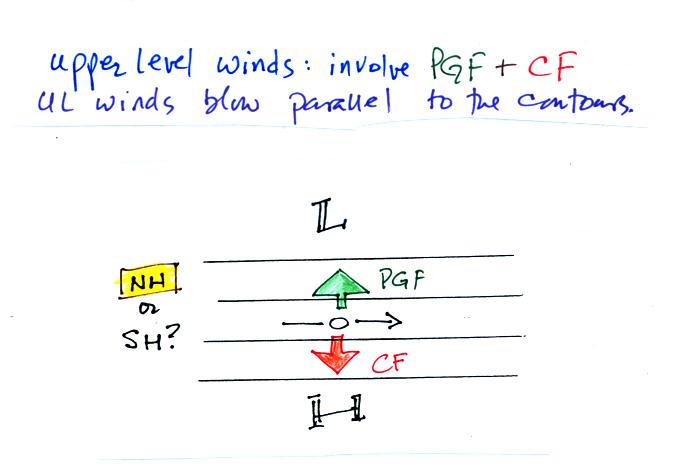
A quick reminder that only the PGF and the CF are important when
considering upper level winds. Upper levels winds blow parallel
to the contours.
In the figure above, we drew in the
pressure gradient force arrow (perpendicular to the contour lines and
pointing toward low pressure). Then we can drew in an equal and
oppositely directed CF so that the net force would be zero. We
then saw that the CF was to the right of the wind and we could then say
this was a N. hemisphere chart.
When air blows across the surface of the earth you must include the
frictional force.
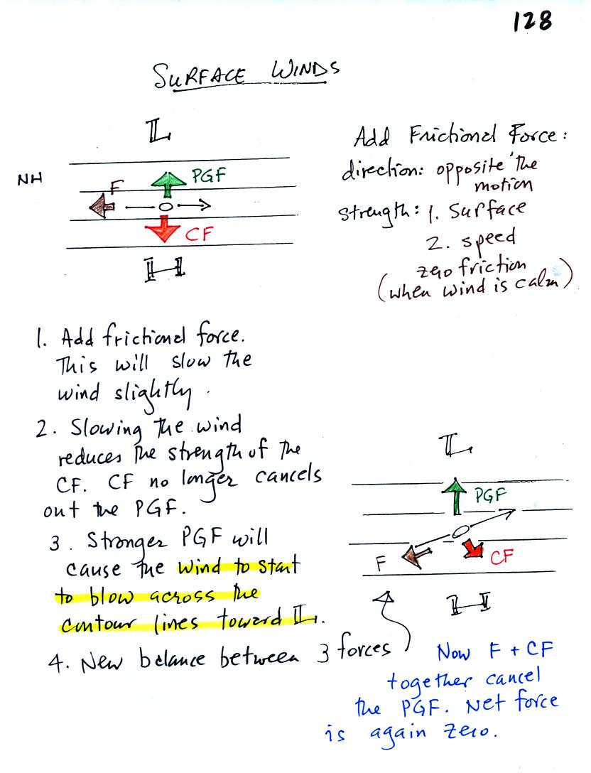
The frictional force will always point in a direction
opposite the
wind. Friction always try to slow moving objects (it doesn't
cause you
to speed up on your bicycle or to veer suddenly to the right or
left).
The strength of the frictional force depends on wind speed (stronger
when the winds are fast and zero when the wind isn't blowing at
all).
Friction also depends on the type of surface the wind is blowing over
(there is less friction when winds blow over the ocean than when
blowing over land).
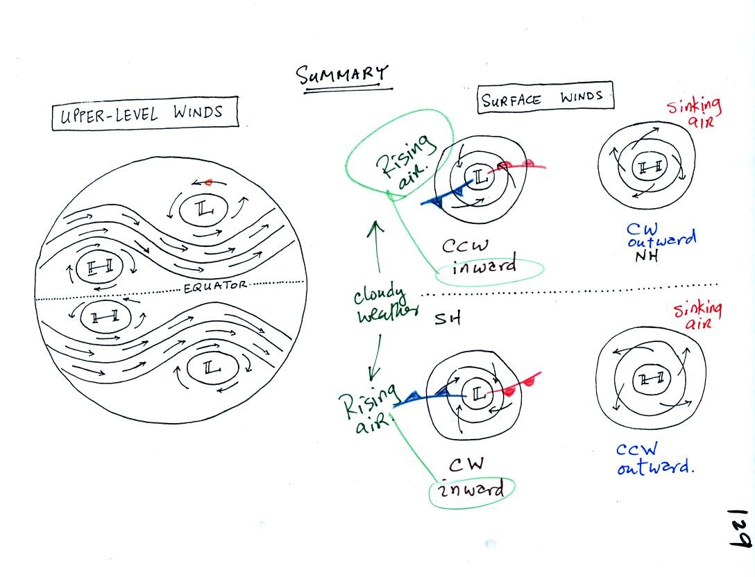
This figure summarizes most everything we have done. The
upper level
winds are shown in the figure at left. The upper level winds blow
parallel to the contour lines.
At right surface winds around centers of high and low pressure are
shown. You should remember from early in the semester that winds
blow counterclockwise and inward around low pressure in the NH.
They blow clockwise and outward around high pressure.
In the southern hemisphere the directions of spin change (clockwise
around low and counterclockwise around high). Winds still blow
converge into low pressure and diverge from centers of high
pressure. This means that rising air (which expands and cools)
and clouds will be found with centers of low pressure in both the
northern and southern hemispheres.
Note the locations and directions of motion of the southern hemisphere
warm and cold fronts. The winds spin clockwise around low
pressure in the southern hemisphere. The coldest air is found in
the south in the southern hemisphere.
Differences
in temperature such
as might develop between a coast and
the ocean or between a city and the surrounding country side can create
horizontal pressure differences. The horizontal pressure gradient can
then produce a wind flow pattern known as a thermal circulation.
These are generally relatively small scale circulations and the
pressure gradient is so much stronger than the Coriolis force that the
Coriolis force can be ignored. We will learn how thermal
circulations develop and then apply to concept to the earth as a
whole
in order to understand large global scale pressure and wind
patterns. You'll find the
following discussion on p. 131 in the photocopied Class Notes.
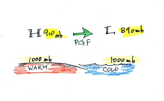
A beach will often become much warmer than the nearby
ocean during
the day (the sand gets hot enough that it is painful to walk across in
barefeet). Pressure will decrease more slowly with increasing
altitude in the warm low density
air than in the cold higher density
air above the ocean. Even when the sea level pressures are the
same over the land and water (1000 mb above) an upper level pressure
gradient can be created.
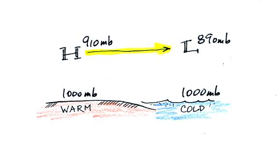
The upper level pressure gradient force will
cause upper level winds to
blow from H (910 mb) toward L (890 mb).
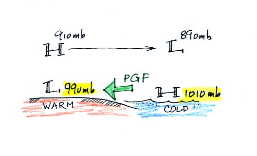
The movement of air above the ground can affect the
surface
pressures. As air above the ground begins to move from left to
right, the surface pressure at left will decrease (from 1000 mb to 990
mb
in the picture above). Adding air at right will increase the
surface pressure there (from 1000 to 1010 mb). This creates a
surface
pressure gradient.
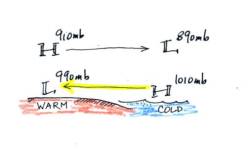
The surface winds blow from high to low. The surface winds and
upper level winds are blowing in opposite directions.
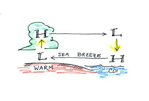
You can complete the circulation loop by adding rising air above the
surface low pressure at left and sinking air above the surface high at
right. The surface winds which blow from the ocean onto land are
called a sea breeze (the name tells you where the winds come
from). Since this air is likely to be moist, cloud formation is
likely when the air rises over the warm ground.
At night the ground cools more quickly than the ocean and becomes
colder than the water. The thermal circulation pattern reverses
direction. Surface winds blow from the land out over the
ocean. This is referred to as a land breeze.
You can
use the thermal circulation concept to understand these circulation
patterns. The following examples weren't shown in class on
Wednesday.

Cities are often warmer than the surrounding
countryside,
especially at night. This is referred to as the urban heat island
effect. This difference in temperature can create a
"country breeze."
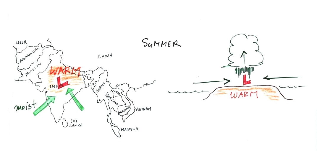
In the summer India and SE Asia become warmer than the
oceans
nearby. Surface low pressure forms over the land, moist winds
blow from the ocean onshore, and very large amounts of rain can
follow. This Asian monsoon (monsoon refers to a seasonal change
in the direction of the prevailing winds) is a large scale circulation
pattern and is more than a thermal circulation. However you can
use the thermal circulation concept to get a basic understanding of
what is going on.
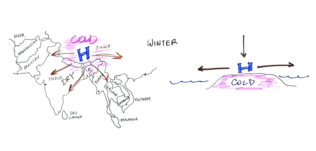
The winds change directions in the winter when the land becomes colder
than the ocean.