Mon., Apr. 16, 2007
The revised Expt. #3 reports were collected today. The revisions
of the Expt. #4 reports are due next Monday, Apr. 23. There are
still several people that haven't turned in their Expt. 4
reports. Time is quickly running out.
A small part of the 1S1P Assignment #3 reports (Topic #9 reports turned
in last week) have been graded and were returned in class.
Wednesday this week is the last 1S1P report due date.
An optional assignment was handed out in class and will be due next
Monday, Apr. 23.
You should now be reading Chapter 10 in the text.
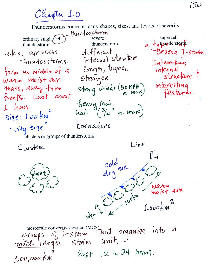
Some general information on different types of
thunderstorms. We will mostly be concerned with ordinary
single-cell thunderstorms
(also referred to as air mass thunderstorms).
Before
looking at how air mass thunderstorms development we should review some
material.
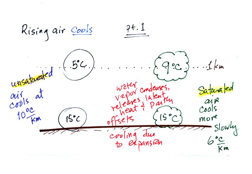
Rising air always expands and cools. It cools at
different rates depending on whether the air is saturated (RH=100%) or
unsaturated. Saturated air cools more slowly with increasing
altitude. The air is expanding and cooling, but condensation of
water vapor inside the rising parcel releases latent heat energy into
the air in the parcel. This latent heat offsets some of the
cooling due to expansion.
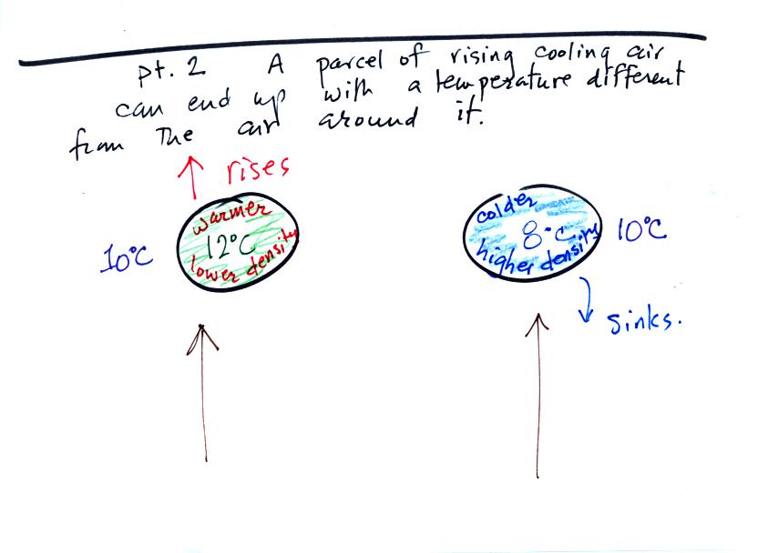
Once air is lifted from the ground up to some level in the
atmosphere, the temperature of the air inside the lifted parcel may be
different from the air outside (we assume energy doesn't flow into or
out of the rising parcel). If the rising air that ends up warmer
than the surroundings the parcel will, after being lifted and released,
begin to rise on its own. If the parcel ends up colder
than the surroundings the parcel will sink.
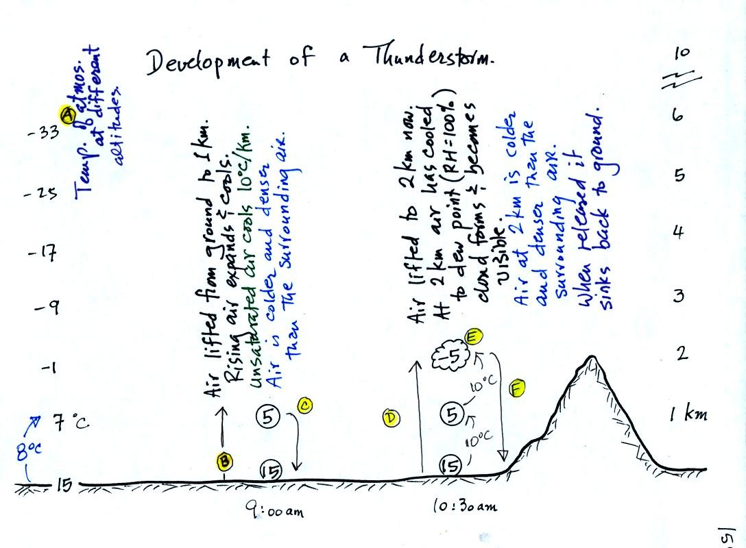
This figure was redrawn after class for clarity.
Refer back and forth between the lettered points in the
figure
above and the commentary below.
The numbers in Column A
show the temperature of the air in the atmosphere at various altitudes
above the ground (note the altitude scale on the right edge of the
figure). On this particular day the air temperature was
decreasing at a rate of 8 C per kilometer. This rate of decrease
is referred to as the environmental lapse rate. Temperature could
decrease more quickly than shown here or less rapidly.
Temperature in the atmosphere can even increase with increasing
altitude
(temperature inversion).
At Point B, some of
the surface air is put into an imaginary container, a parcel.
Then a meterological process of some kind lifts the air to 1 km
altitude (in Arizona in the summer, sunlight heats the ground and air
in contact with the ground, the warm air becomes bouyant). The
rising air will expand and cool as it is
rising. Unsaturated (RH<100%) air cools at a rate of 10 C per
kilometer. So the 15 C surface air will have a temperature of 5 C
when it arrives at 1 km altitude. We assume that energy doesn't
flow back and forth between the air inside and outside the parcel (an
adiabatic process).
At Point C note that
the air inside the parcel is slightly colder than the air outside (5 C
inside versus 7 C outside). The air inside the parcel will be
denser than the air outside and, if released, the parcel will sink back
to the
ground.
By 10:30 am the parcel is being lifted to 2 km as shown at Point D. It is still
cooling 10 C for every kilometer of altitude gain. At 2 km, at Point E the
air has cooled to its dew point temperature and a cloud has
formed. Notice at Point
F, the air in the parcel or in the cloud (-5 C) is still colder
and denser than the surrounding air (-1 C), so the air will sink back
to the ground and the cloud will disappear. Still no thunderstorm
at this point.
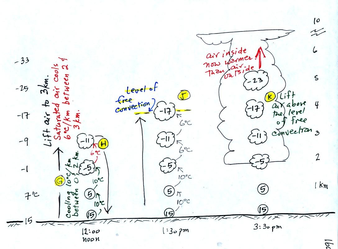
At noon, the air is lifted to 3 km. Because the
air
became saturated at 2 km, it will cool at a different rate
between 2 and
3 km altitude. It cools at a rate of 6 C/km instead of 10
C/km. The saturated air cools more slowly because release of
latent heat
during condensation offsets some of the cooling due to
expansion. The air that arrives at 3km, Point H, is again still
colder than the
surrounding air and will sink back down to the surface.
By 1:30 pm the air is getting high enough that it becomes neutrally
bouyant, it has the same temperature and density as the air around it
(-17 C inside and -17 C outside). This is called the level of
free convection, Point J in the figure.
If you can somehow or another lift air above the level of free
convection it will find itself warmer and less dense than the
surrounding air as shown at Point K and will float upward to the top of
the troposphere on its own. The thunderstorm developed
only after getting above the level of free convection.
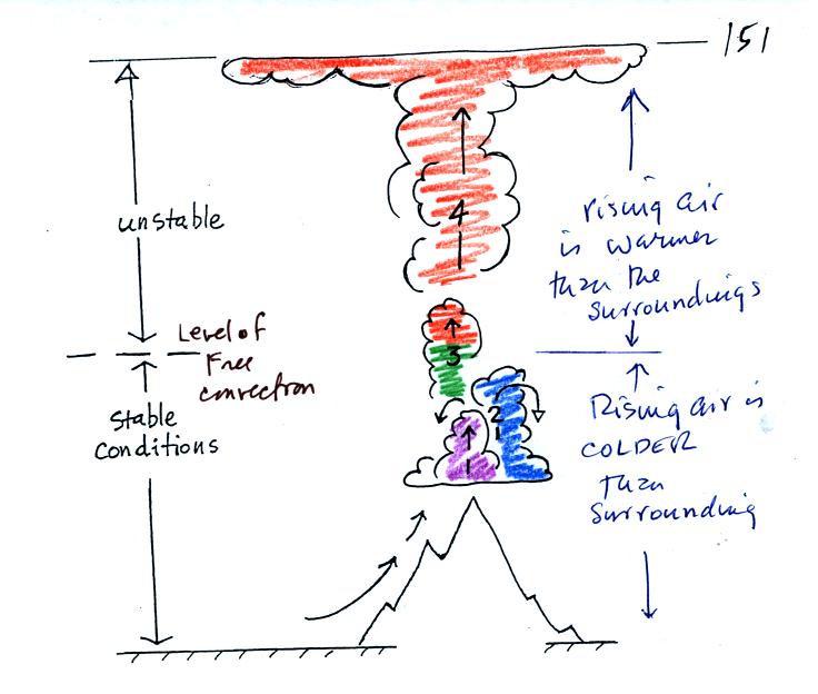
The top portion of this figure repeats what we just
discussed: it takes some effort and often a good part of
the
day before a thunderstorm forms. The air must be lifted to or
above the level of free convection. The level of free convection
can change from one day to the next.
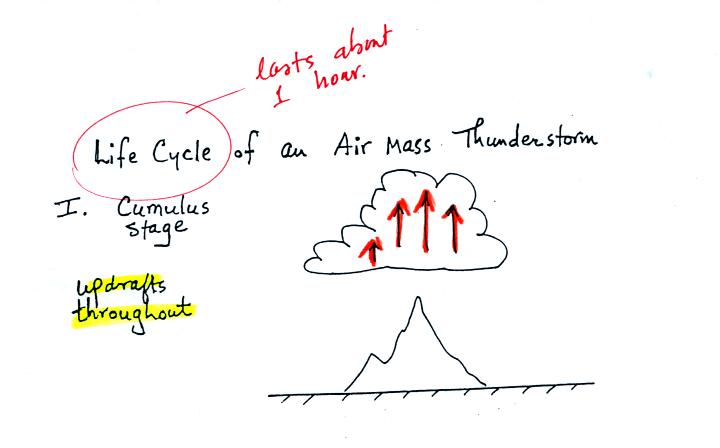
An ordinary single cell
thunderstorm goes through a 3-stage life cycle. In
the first stage, the cumulus stage, you would find updrafts throughout
the inside of the cloud.

Once precipitation has formed and grown to a certain size,
it will
begin to fall and drag air downward with it. This is the
beginning of the
mature stage where you find both an updraft and a downdraft inside the
cloud. The falling precipitation will also pull in dry air from
outside the thunderstorm (this is called entrainment).
Precipitation will mix with this drier air and evaporate. The
evaporation will strengthen the downdraft (the
evaporation cools the air and makes it more dense). The
thunderstorm is strongest in the mature stage. This is when the
heaviest rain, strongest winds, and most of the lightning occur.
Eventually the downdraft spreads throughout the inside of the cloud and
interferes with or cuts off the updraft. This marks the beginning
of the end for this thunderstorm. In the dissipating stage you
would find just weak downodrafts throughout the interior of the cloud.
Note how the winds from one thunderstorm can cause a region of
convergence on one side of the original storm and can lead to the
development of new storms. Preexisting winds refers to winds that
were blowing before the thunderstorm formed.