Monday Apr. 30, 2007
We learned
last week the first step in hurricane formation is a meteorological
process of some kind (such as an easterly wave) that can cause surface
winds to converge. If the atmosphere is unstable, the
rising air motion created by the convergence can cause a cluster of
thunderstorms to begin to form.
The next figure shows what can happen
next.

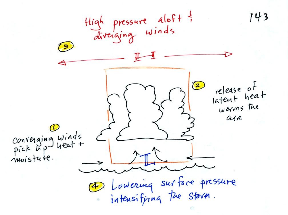
1. The
converging winds pick
up heat and moisture from the ocean. These are the two mains
sources of energy for the hurricane.
2. Rising air cools and thunderstorm clouds form. The
release of latent heat during condensation warms the atmosphere.
The core of a hurricane is warm.
3. Pressure decreases more slowly with increasing altitude
in the warm core of the hurricane. The result is that pressure at
the top center of the hurricane is higher than the pressure further out
from the hurricane (pressure at the top center is still lower than the
pressure at the bottom center of the hurricane). Upper levels
winds diverge and spiral outward
from the top center of the hurricane.
4. The upper level divergence causes the surface pressure
to decrease. The speed of the converging surface winds increases
and the storm intensifies. The converging winds pick up
additional heat and moisture which warms the core of the hurricane even
more. The upper level high pressure and the upper level
divergence increase. The increased divergence lowers the surface
pressure even more.

Stages of storm development. The developing storm
receives a name
when it reaches tropical storm strength. To be considered a
hurricane the winds must be 74 MPH or greater (75 MPH might be easier
to remember). Note the weather map symbols for northern
hemisphere tropical storms and hurricanes (counterclockwise rotation)

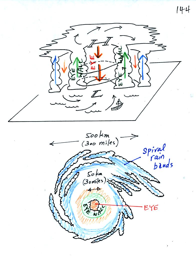
A crossectional view of a mature hurricane and a picture
like you might
see on a satellite photograph.
Sinking air in the very center of a hurricane produces the clear skies
of the eye, a hurricane's most distinctive feature. The eye is
typically a few 10s of miles across, though it may only be a few miles
across in the strongest hurricanes.
A ring of strong thunderstorms, the eye wall, surrounds the eye.
This is where the hurricane's strongest winds found.
Additional concentric rings of thunderstorms are found as you move
outward from the center of the hurricane. These are called rain
bands. These usually aren't visible until you get to the outer
edge of the hurricane because they are covered by high altitude clouds.

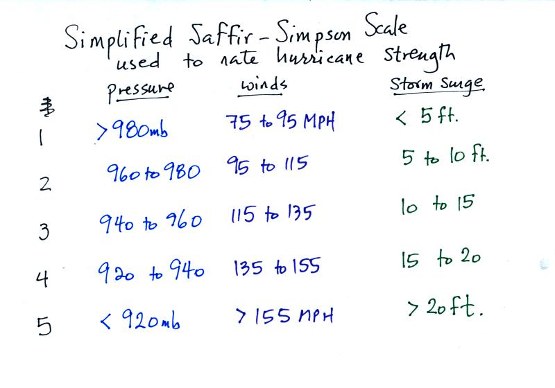
Here is an easy to remember version of the Saffir Simpson
scale used to
classify hurricane strength and damage potential.
If you remember that winds must be 75 MPH or higher in order for a
tropical cyclone to be a hurricane. In this easy to remember
scale the winds increase by 20 MPH as you move up the scale.
Pressures decrease in 20 mb increments (start at 1000 mb and go down
from there) and the height of the storm
surge increases by 5 feet. It is thought that parts of the
Louisiana and Mississippi coasts were hit with a 30 ft. storm surge as
Hurricane Katrina moved onshore in 2005.

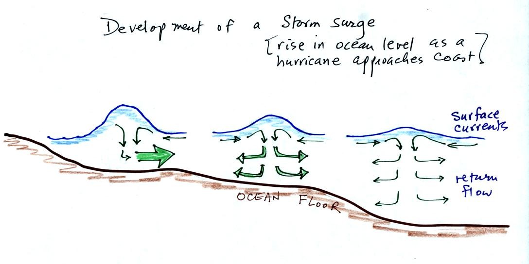
Out at sea, the converging surface
winds
create
surface
currents
in the
ocean that transport water toward the center of the hurricane.
The rise in ocean level is probably only a few feet, though the waves
are much larger. A return flow develops underwater that carries
the water back to where it came from.
As the hurricane approaches shore, the ocean becomes
shallower.
The return flow must pass through a more restricted space. A rise
in ocean level will increase the underwater pressure and the return
flow will speed up. More pressure and an even faster return flow
is needed as the hurricane gets near the coast.
Here is a link to the storm surge website
(from the Hurricane Research Division of the Atlantic Oceanographic and
Meteorological Labororatory). It has an interesting animation
showing output from the SLOSH model used to predict hurricane storm
surges.

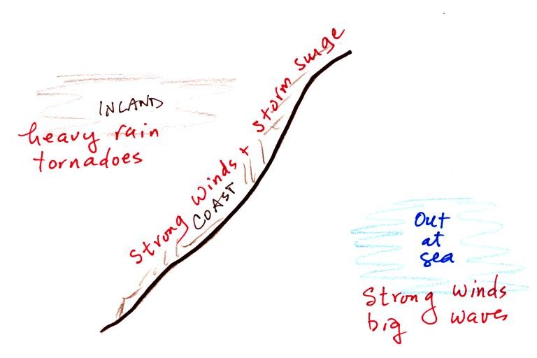
Hurricanes can, of course, be very
destructive. Out at
sea the
main hazards are the strong winds and the large waves. The
Perfect Storm by Sebastian Junger describes the sinking of the Andrea
Gail in a strong hurricane like storm in October 1991. The exact
fate of the fishing ship is not known but it may have been turned end
over end by a large wave (pitch poled). Large waves can also
flood a ship and begin to fill it with water.
Along a coast the greatest threat is from the hurricane winds and the
storm surge. Large waves are superimposed on the storm surge.
The hurricanes winds slow quickly as it moves onshore, though
tornadoes may form. The biggest threat is from flooding.
Hurricanes can easily drop a foot or more of rain on an area as they
pass through.
