Monday Nov. 24, 2008
click here to download today's notes in Microsoft WORD format

Music today was The Fool from the Olds 97s (from their Blame it on Gravity CD).

Remember that class on Wednesday afternoon has been cancelled.  I will be in my office most of the day on Wednesday (except around lunch) should you want to discuss any class related matters (or unrelated matters).

The final 1S1P reports were collected today.  My plan is to make a superhuman effort to get most of this work graded by the time you all return from Thanksgiving.  Of course there's always the possibility that I'll fail miserably.

All of the Experiment reports that I had in my possession have been graded and were available for pickup in class today.

The Quiz #4 Study Guide pt. 1 and pt. 2 are now available online.  This is all you will need to prepare for next week's quiz.

As promised here are some pictures from my winter vegetable garden including a few pictures not shown in class.

This figure tries to explain how a cluster of thunderstorms can organize and intensify into a hurricane.


1.  Converging surface winds pick up heat and moisture from the ocean.  These are the two mains sources of energy for the hurricane.

2.   Rising air cools and thunderstorm clouds form.  The release of latent heat during condensation warms the atmosphere.  The core of a hurricane is warm.

3.   Pressure decreases more slowly with increasing altitude in the warm core of the hurricane.  The result is that pressure at the top center of the hurricane is higher than the pressure at the top edges of the hurricane (pressure at the top center is still lower than the pressure at the bottom center of the hurricane).  Upper levels winds diverge and spiral outward from the top center of the hurricane.

4.   The upper level divergence will cause the surface pressure at the center of the hurricane to decrease.  The speed of the converging surface winds increases and the storm intensifies.  The converging winds pick up additional heat and moisture which warms the core of the hurricane even more.  The upper level high pressure and the upper level divergence increase.  The increased divergence lowers the surface pressure even more.

Here's another illustration of hurricane intensification (a slightly different and hopefully clearer version than was shown in class)


In the figure at left the upper level divergence is stronger than the surface convergence.  The surface low pressure will decrease.  The decrease in surface pressure will cause the converging surface winds to blow faster.

In the middle picture, the surface low pressure is lower, the surface convergence is stronger.  The upper level divergence has also been strengthened a little bit.  The upper level divergence is still stronger than the surface convergence so the surface low pressure will decrease even more.

In the right figure the surface low pressure has decreased enough that the surface convergence now balances the upper level divergence.  The storm won't strengthen any more.

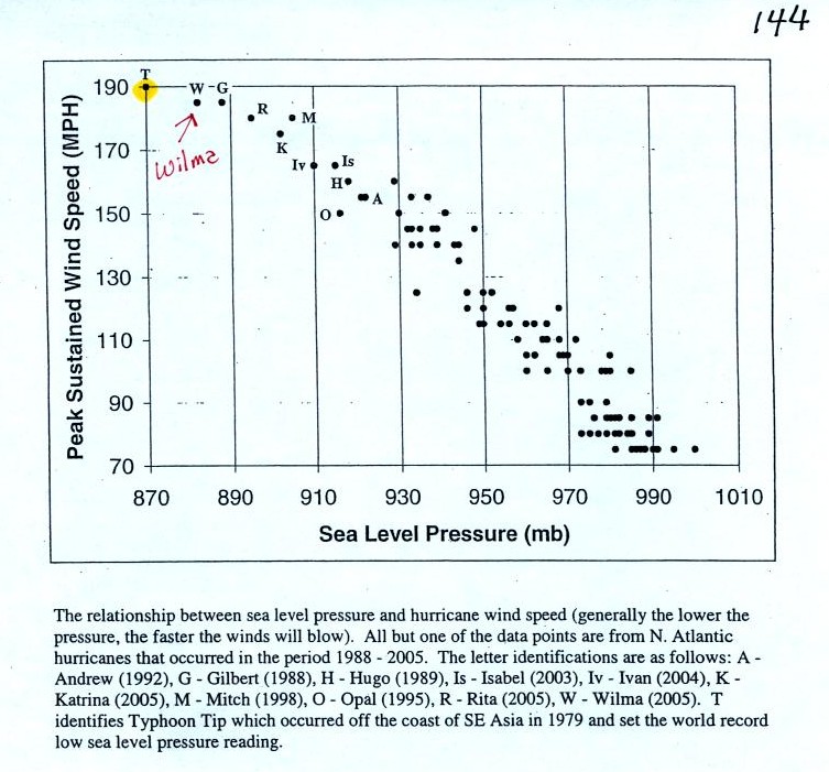
Generally speaking the lower the surface pressure at the center of a hurricane the stronger the storm and the faster the surface winds will blow.

This figure tries to show the relationship between surface pressure and surface wind speed.  The world record low sea level pressure reading, 870 mb, was set by Typooon Tip off the SE Asia coast in 1979.  Sustained winds in that storm were 190 MPH.  Three 2005 Atlantic hurricanes: Wilma, Rita, and Katrina had pressures in the 880 mb to 900 mb range and winds ranging from 170 to 190 MPH.


The stages of storm development that lead up to a hurricane are shown at the bottom of p. 143a in the photocopied ClassNotes.


A tropical disturbance is just a localized cluster of thunderstorms that a meterologist might see on a satellite photograph.  But this would merit observation because of the potential for further development.  Signs of rotation would be evidence of organization and the developing storm would be called a tropical depression.

In order to be called a tropical storm the storm must organize a little more, and winds must increase to 35 knots.  The storm receives a name at this point.  Finally when winds exceed 75 MPH (easier to remember than 65 knots or 74 MPH) the storm becomes a hurricane.


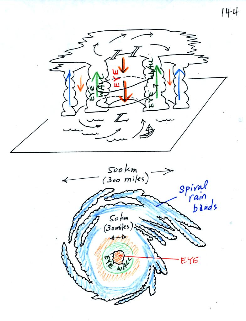
A crossectional view of a mature hurricane (top) and a picture like you might see on a satellite photograph (below). 

Sinking air in the very center of a hurricane produces the clear skies of the eye, a hurricane's most distinctive feature.  The eye is typically a few 10s of miles across, though it may only be a few miles across in the strongest hurricanes. 

A ring of strong thunderstorms, the eye wall, surrounds the eye.  This is where the hurricane's strongest winds are found. 

Additional concentric rings of thunderstorms are found as you move outward from the center of the hurricane.  These are called rain bands.  These usually aren't visible until you get to the outer edge of the hurricane because they are covered by high altitude layer clouds.


Hurricanes are, of course, very destructive.

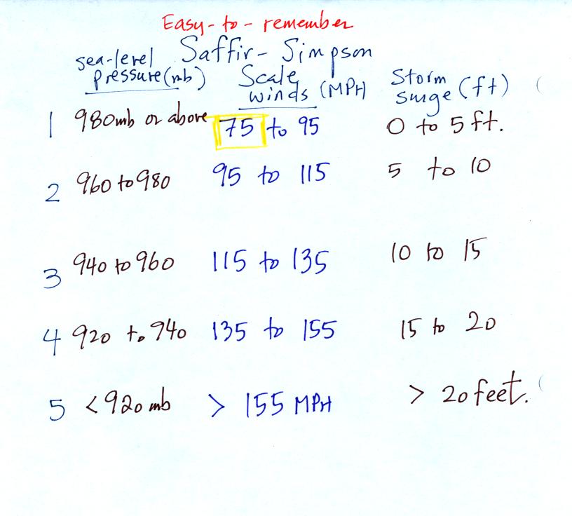
The Saffir-Simpson scale is used to rate hurricane intensity (just as the Fujita scale is used with tornadoes).
A simplified version of the Saffir-Simpson scale is shown above.  Pressure decreases by 20 mb, wind speeds increase by 20 MPH, and the height of the storm surge increases 5 feet for every increase in Saffir Simpson Scale rating.  You don't need to remember all the numbers.  Just remember that there are 5 categories on the scale, category 1 is the weakest.  Hurricane winds must be over 75 MPH for the storm to be called a hurricane. 


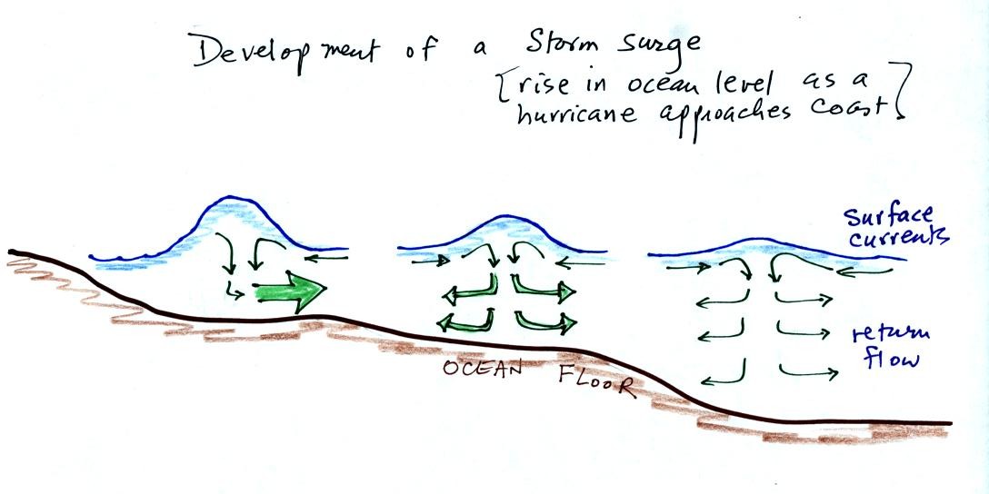
The following figure shows how storm surges develop. 


Out at sea, the converging surface winds create surface currents in the ocean that transport water toward the center of the hurricane.  The rise in ocean level is probably only a few feet, though the waves are much larger.  A return flow develops underwater that carries the water back to where it came from.

As the hurricane approaches shore, the ocean becomes shallower.  The return flow must pass through a more restricted space.  A rise in ocean level will increase the underwater pressure and the return flow will speed up.  More pressure and an even faster return flow is needed as the hurricane gets near the coast.

Here is a link to the storm surge website (from the Hurricane Research Division of the Atlantic Oceanographic and Meteorological Labororatory).  It has an interesting animation showing output from the SLOSH model used to predict hurricane storm surges and the flooding they can cause.

We watched another short video at the end of class.  It mostly described the arrival of Hurricane Camille along the Mississippi coast in 1969.  Camille is the 2nd most intense hurricane to hit the US (see p. 146a in the photocopied
ClassNotes)


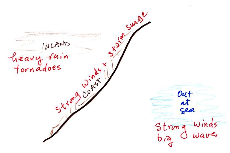
The following figure wasn't shown in class.  The storm surge probably causes the most hurricane damage along a coastline.  Further out at sea strong winds and high seas are the biggest hazard.  Once a hurricane moves onshore it weakens very rapidly (friction slows the winds and the hurricane is cut off from its supply of moisture).  However very heavy rains, thunderstorms and tornadoes can remain a threat over a large area for days to come.


The following information wasn't covered in class.
The 2005 hurricane season (the year Hurricane Katrina hit New Orleans) was unusual in many respects.  

3 of the 10 most intense Atlantic hurricanes ever ( Wilma, Rita, and Katrina) occurred in 2005 (you'll find the top 10 listed on p. 146a in the photocopied classnotes).  Wilma became the most intense hurricane of all time in the Atlantic, beating out Hurricane Gilbert (1988) which was featured in the video tape segment shown in class last Friday.

On average there are about 10 named storms (tropical storms and hurricanes) in the Atlantic per year.  Before 2005 the record was 21 storms.  There were 28 storms in 2005 which blew the old record out of the water.

Katrina was the third most intense hurricane to hit the mainland US and easily became the most costly natural disaster in US history. 

Fortunately none of the 2005 storms came close to becoming the deadliest hurricane in US history. That distinction belongs to the 1900 Galveston hurricane.