Tuesday Dec. 2, 2008

Some upbeat music from Squirrel Nut Zippers for the T Th class this morning just coming back from their Thanksgiving Break.

All of the experiment reports that I had in my possession have been graded and can be picked up in class.  First drafts can be revised but revised reports need to be turned in as soon as possible.  The 1S1P Topic #8 (story) reports have been graded.  Several people have now earned 45 1S1P pts, the maximum number allowed.  The list is likely to change on an almost daily basis as additional 1S1P reports are graded.

Pt. 1 and Pt. 2 of the Quiz #4 Study Guide are now available online.


We had a little bit more material on hurricanes to cover before moving on to a new topic.

A crossectional view of a mature hurricane (top) and a picture like you might see on a satellite photograph (below). 

Sinking air in the very center of a hurricane produces the clear skies of the eye, a hurricane's most distinctive feature.  The eye is typically a few 10s of miles across, though it may only be a few miles across in the strongest hurricanes. 

A ring of strong thunderstorms, the eye wall, surrounds the eye.  This is where the hurricane's strongest winds are found. 

Additional concentric rings of thunderstorms are found as you move outward from the center of the hurricane.  These are called rain bands.  These usually aren't visible until you get to the outer edge of the hurricane because they are covered by high altitude layer clouds. 


This figure tries to show the relationship between surface pressure and surface wind speed.  The world record low sea level pressure reading, 870 mb, was set by Typooon Tip off the SE Asia coast in 1979.  Sustained winds in that storm were 190 MPH.  Three 2005 Atlantic hurricanes: Wilma, Rita, and Katrina had pressures in the 880 mb to 900 mb range and winds ranging from 170 to 190 MPH.


Hurricanes are, of course, very destructive.
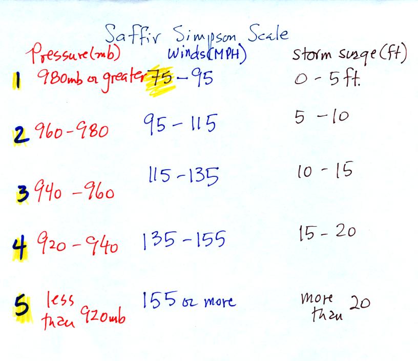

The Saffir-Simpson scale is used to rate hurricane intensity (just as the Fujita scale is used with tornadoes).
A simplified version of the Saffir-Simpson scale is shown above.  Pressure decreases by 20 mb, wind speeds increase by 20 MPH, and the height of the storm surge increases 5 feet for every increase in Saffir Simpson Scale rating.  You don't need to remember all the numbers.  Just remember that there are 5 categories on the scale, category 1 is the weakest.  Hurricane winds must be over 75 MPH for the storm to be called a hurricane. 


The following figure shows how storm surges develop.


Out at sea, the converging surface winds create surface currents in the ocean that transport water toward the center of the hurricane.  The rise in ocean level is probably only a few feet, though the waves are much larger.  A return flow develops underwater that carries the water back to where it came from.

As the hurricane approaches shore, the ocean becomes shallower.  The return flow must pass through a more restricted space.  A rise in ocean level will increase the underwater pressure and the return flow will speed up.  More pressure and an even faster return flow is needed as the hurricane gets near the coast.

Here is a link to the storm surge website (from the Hurricane Research Division of the Atlantic Oceanographic and Meteorological Labororatory).  It has an interesting animation showing output from the SLOSH model used to predict hurricane storm surges and the flooding they can cause.

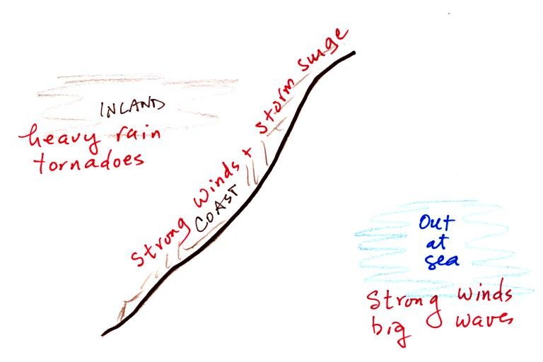
The storm surge probably causes the most hurricane damage along a coastline.  Further out at sea strong winds and high seas are the biggest hazard.  Once a hurricane moves onshore it weakens very rapidly (friction slows the winds and the hurricane is cut off from its supply of moisture).  However very heavy rains, thunderstorms and tornadoes can remain a threat over a large area for days to come.


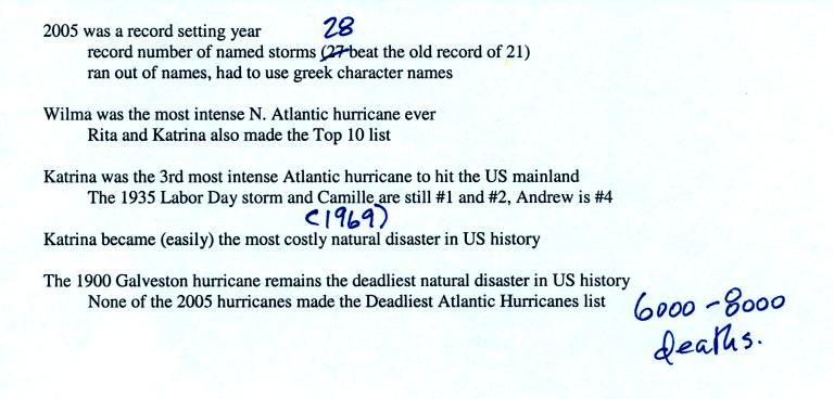
The information above is from the bottom of the  detailed hurricane reviewIt contains some information about the 2005 hurricane season (the year that Katrina hit New Orleans) which was a record breaking year (this is not material you need to remember for the quiz).


Click on this link, for a brief introduction to lightning, the topic that we spent the rest of today's class on.

Lightning kills about 100 people every year in the United States (more than tornadoes or hurricanes but less than flooding, summer heat and winter cold) and is the cause of about 30% of all power outages.  In the western United States, lightning starts about half of all forest fires.  Lightning caused fires are a particular problem at the beginning of the thunderstorm season in Arizona.  Early in the summer the air underneath thunderstorms is still relatively dry.  Rain falling from a thunderstorm will often evaporate before reaching the ground.  Lightning then strikes dry ground, starts a fire, and there isn't any rain to put out or at least slow the spread of the fire.  This is so called dry lightning.

Lighning is most commonly produced by thunderstorms (it has also be observed in dust storms and volcanic eruptions).


A typical summer thunderstorm in Tucson (found on p. 165 in the photocopied Classnotes).  Remember that even in the summer a large part of the middle of the middle of the cloud is found at below freezing temperatures and contains a mixture of super cooled water droplets and ice crystals.  This is where the ice crystal process of precipitation formation operatures and is also where electrical charge is created.  Doesn't it seem a little unusual that electricity can be created in such a cold and wet environment?


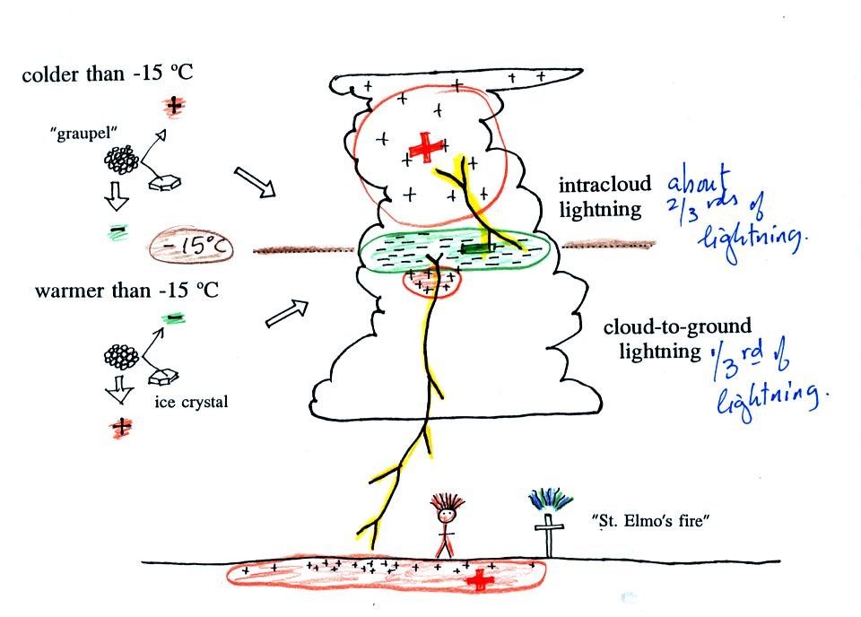
Collisions between precipitation particles produce the electrical charge needed for lightning.  When temperatures are colder than -15 C, graupel becomes negatively charged after colliding with a snow crystal.  The snow crystal is positively charged and is carried up toward the top of the cloud by the updraft winds.  At temperature warmer than -15 (but still below freezing), the polarities are reversed.  Large positive and negative charge centers begin to build up inside the cloud.  When the electrical attrative forces between these charge centers gets high  enough lightning occurs.  Most lightning (2/3) stays inside the cloud and travels between the main positive charge center near the top of the cloud and a large layer of negative charge in the middle of the cloud; this is intracloud lightning.  About 1/3 of all lightning flashes strike the ground.  These are called cloud-to-ground discharges (actually negative cloud-to- ground

A couple of interesting things that can happen at the ground when the electrical forces get high enough.  Attraction between positive charge in the ground and the layer of negative charge in the cloud can become strong enough that a person's hair will literally stand on end (see p. 307 in your text, reproduced below).  This is incidentally a dangerous situation to be in as lightning might be about to strike.  St. Elmo's fire is a faint electrical discharge that sometimes develops at the tops of elevated objects during thundestorms.  It was first observed coming from the tall masts of sailing ships at sea (St. Elmo is the patron saint of sailors).


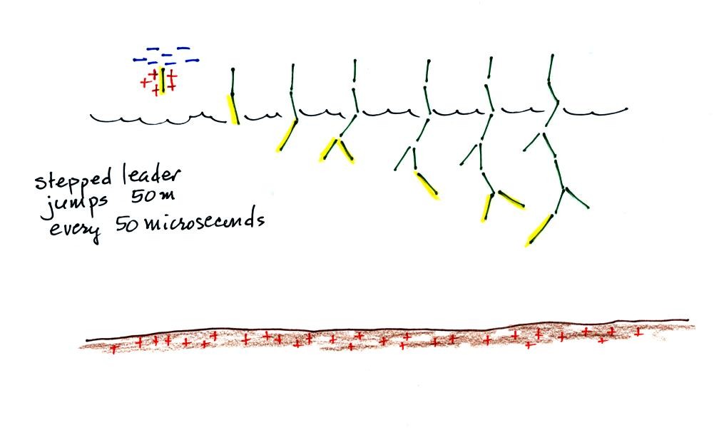
Most cloud to ground discharges begin with a negatively charged downward moving stepped leader.  It makes its way down toward the cloud in 50 m jumps that occur every 50 millionths of a second or so.  Every jump produces a short flash of light.  An upward discharge is initiated when the stepped leader nears the ground.  A powerful return stroke travels back up the channel (and out into all the branches) once the upward discharge and the stepped leader meet.  These three steps are shown in additional detail below.


A sequence of stepped leader steps.  Note each of the channels in the drawing should actualy be superimposed on each other.   There is just a single channel that every 50 microseconds of so gets 50 meters longer.


Several positively charged upward discharges begin to travel upward from the ground. One of these will eventually intercept the stepped leader. 
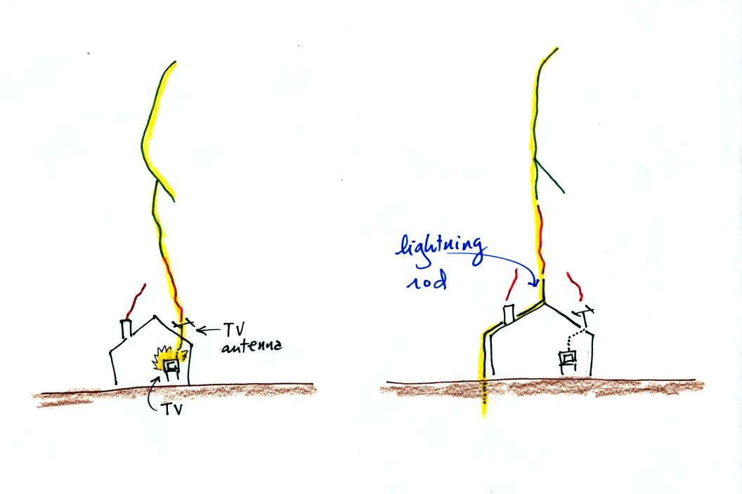
This is what determines what will be struck by the lightning.  Lightning doesn't really know what it will strike until it gets close to the ground.  Lightning rods take advantage of this principle.


Houses with and without lightning rods are shown above.  When lightning strikes the house without a lightning rod the powerful return stroke travels into the house destroying the TV and possibly starting the house on fire. 
A lightning rod is supposed to intercept the stepped leader and safely carry the lightning current around the house and into the ground.


The connection between the stepped leader and the upward discharge creates a "short circuit" between the charge in the cloud and the charge in the ground.  A powerful current travels back up the channel from the ground toward the cloud.  This is the return stroke.  Large currents (typically 30,000 amps in the first return stroke) heat the air to around 30,000K (5 times hotter than the surface of the sun) which causes the air to explode.  When you hear thunder, you are hearing the sound produced by this explosion.

Here is a nice stepped leader - upward connecting discharge - return stroke animation

Many cloud-to-ground flashes end at this point. 
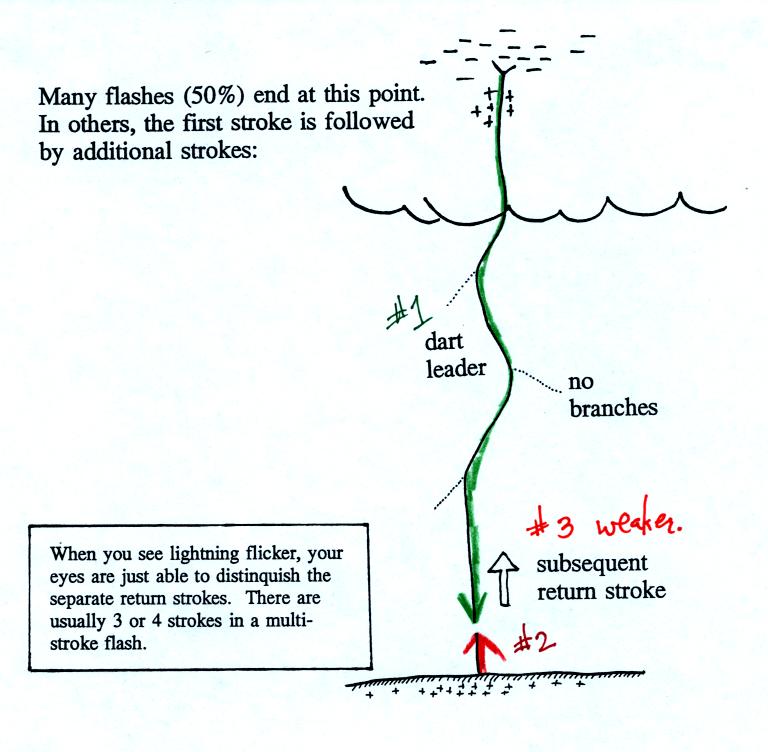
In about 50% of cloud to ground discharges, the stepped leader-upward discharge-return stroke sequence repeats itself with a few subtle differences.


A downward dart leader travels from the cloud to the ground. The dart leader doesn't step but travels smoothly and follows the channel created by the stepped leader (avoiding the branches).  It is followed by a slightly less powerful subsequent return stroke that travels back up the channel to the cloud.

A normal still photograph would capture the separate return strokes superimposed on each other.  If you bumped or moved the camera during the photograph the separate return strokes would be spread out on the image.

The image above shows a multiple stroke flash consisting of 4 separate return strokes.
There is enough time between separate return strokes (around 1/10 th second) that your eye can separate the individual flashes of light.
When lightning appears to flicker you are seeing the separate return strokes in a multiple stroke flash.  The whole flash usually lasts 0.5 to 1 second.


Here are some unusual types of lightning.

Occasionally a lightning stroke will travel from the positive charge region in the top of the thunderstorm cloud to ground.  These types of strikes are more common at the ends of storms and in winter storms.  This is probably because the top part of the cloud gets pushed sideways away from the middle and bottom portions of the cloud.  Positive strokes are very powerful.  They sometimes produce an unusually loud and long lasting clap of thunder.


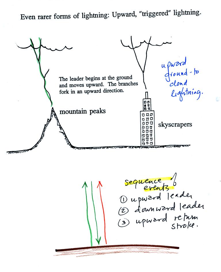
Here's an even rarer form of lightning.  Lightning sometimes starts at the ground and travels upward.  Upward lightning is generally only initiated by mountains and tall objects such as a skyscraper or a tower of some kind.  Note the discharge is different in another way also.  These discharges are initiated by an upward leader.  This is followed by not by a return stroke but by a more normal downward leader.  Once the 2nd leader reaches the ground, an upward return stroke travels back up the channel to the cloud.

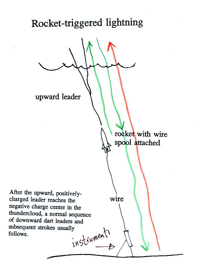
Scientists are able to trigger lightning by firing a small rocket up toward a thunderstorm.  The rocket is connected by a thin wire to the ground.  When the rocket gets 50 to 100 m above the ground upward lightning will develop off of the top of the wire.

Scientists are able to take closeup photographs and make measurements of lightning currents using triggered lightning.  Triggered lightning can also be used to test the operation of lightning protection devices.  A short video showing rocket triggered lightning experiments in Florida was shown at the end of class.