Thunderstorms produce a variety of interesting and potential very
destructive phenomena such as lightning, strong winds, hail, heavy
rainfall, and tornadoes. Before getting into all of the details
here is a brief introduction.
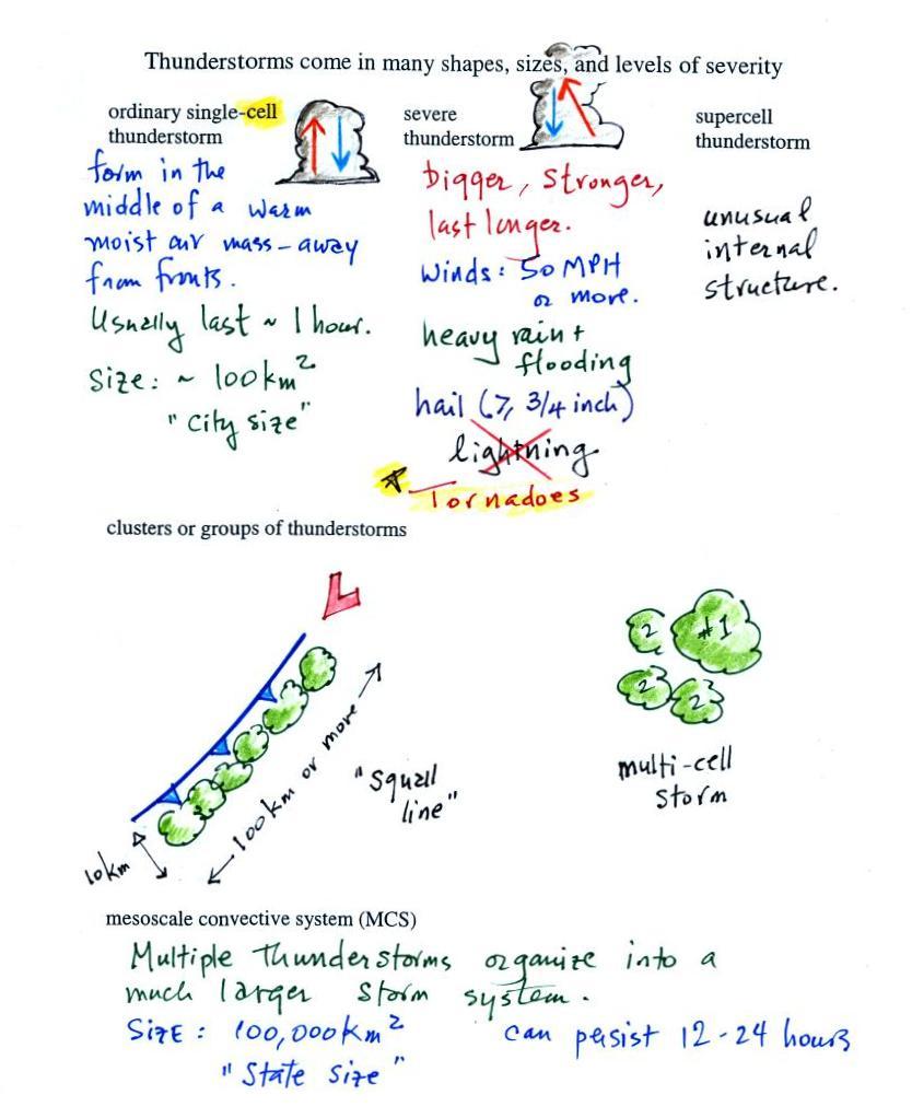
Tilted updrafts are found in severe and supercell thunderstorms.
We will learn why this allows those storms to get bigger, stronger, and
last longer. Storms with strong updrafts can produce large
hailstones. Sometimes the tilted updraft will begin to rotate,
this can produce tornadoes. Supercell thunderstorms have a
complex internal
structure.
Thunderstorms often form in clusters or lines, often ahead of cold
fronts. These are multiple
cell storm systems and can cover a larger area.
We won't learn much about mesoscale convective systems. These are
much larger, "state size", storm
systems that can last 12 to 24 hours.
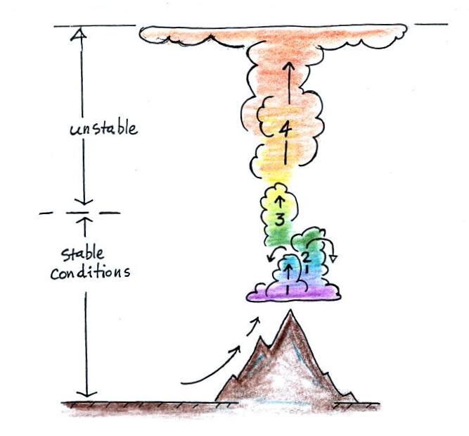
Air must be lifted above the level of free convection in order for
a thunderstorm to be initiated. The lead up to this often takes
the better part of a day. We attempt to show this in the
figure below. Early in the day air is only getting a little bit
of an upward push. This is shown at Point 1. The rising air
finds itself cooler and denser than the surrounding air and sinks back
down toward the ground. As the day goes on the upward pushes get
stronger. Air might make it to Point 2 by noon but the result is
still the same. Finally by mid-afternoon perhaps, air is lifted
above the LFC, finds itself warmer and less dense than the surrounding
air, and explodes upward on its own.
Once a
thunderstorm develops it then goes through 3 stages.
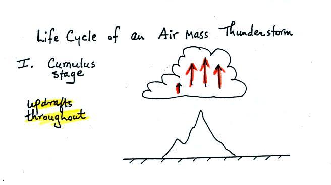
In the
first stage you would only find updrafts inside the cloud (that's all
you need to know about this stage, you don't even need to remember its
name).
Once precipitation has formed and grown to a certain size, it will
begin to
fall and drag air downward with it. This is the beginning of the
mature
stage where you find both an updraft and a downdraft inside the
cloud.
The falling precipitation will also pull in dry air from outside the
thunderstorm (this is called entrainment). Precipitation will mix
with
this drier air and evaporate. The evaporation will strengthen the
downdraft
(the evaporation cools the air and makes it more
dense).
The thunderstorm is strongest in the mature stage. This is when
the
heaviest rain, strongest winds, and most of the lightning occur.
Eventually the downdraft spreads
horizontally throughout the inside of
the
cloud and begins to interfere with the updraft. This marks the
beginning of the end for this thunderstorm.
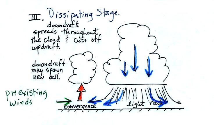
The
downdraft eventually fills the interior of the cloud. In this is
the dissipating stage you would only find weak downodrafts
throughout the cloud.
Note how the winds from one
thunderstorm can cause a region of
convergence on
one side of the original storm and can lead to the development of new
storms. Preexisting winds refers to winds that were blowing
before the
thunderstorm formed. Convergence between the prexisting and the
thunderstorm downdraft winds creates rising air that can initiate a new
thunderstorm.
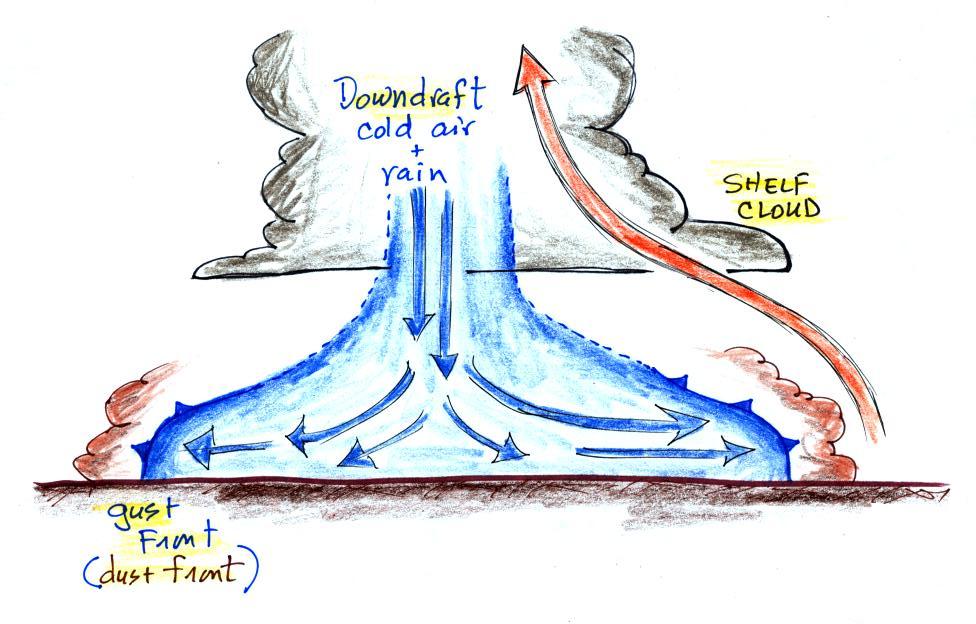
The
picture below shows some of the features at the base of a thunderstorm.
The cold downdraft air spilling out of
a
thunderstorm hits the ground
and
begins to move outward from underneather
the
thunderstorm. The leading edge of this outward moving air is
called a
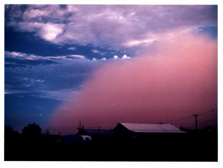
gust front. You can think of it as a dust front because the gust
front
winds often stir up a lot of dust here in the desert southwest (see
below).
The
gust front in this picture (taken
near Winslow, Az) is moving from the right
to the
left. Visibility in the dust cloud can drop to near zero which
makes this
a serious hazard to automobile traffic. Dust storms like this are
sometimes called "haboobs".
There's lots of video on YouTube of an impressive dust storm that
occurred in July2011. Here's an example from
Gilbert Arizona. Another from
South Mountain which is, I think, in the Pheonix area.
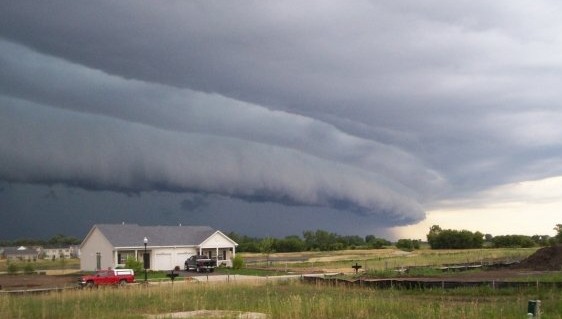
The following picture shows a shelf
cloud.
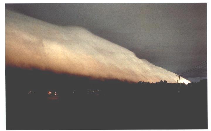
Warm
moist air if lifted by the cold air behind the gust front which is
moving from left
to right in this picture. The shelf cloud is very close to the
ground, so
the warm air must have been very
moist because it didn't have to rise and cool much before it became
saturated and a
cloud
formed.
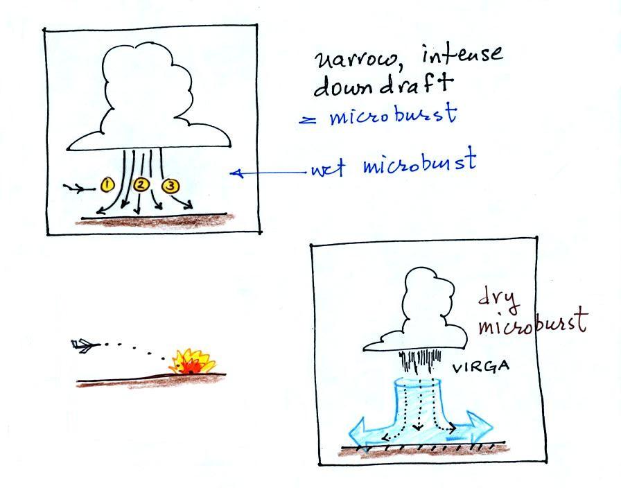
A
narrow intense downdraft is called a microburst. At the ground
microburst winds will sometimes reach 100 MPH (over a limited area);
most
tornadoes have winds of 100 MPH or less. Microburst winds can
damage
homes (especially mobile homes that aren't tied to the ground), uproot
trees,
and seem to blow over a line of electric power poles at some point
every summer
in Tucson.
Microbursts
are a serious threat to
aircraft
especially when they are close to the ground during landing or
takeoff.
An inattentive pilot encountering headwinds at Point 1 might cut back
on the
power. Very quickly the plane would lose the headwinds (Point 2)
and then
encounter tailwinds (Point 3). The plane might lose altitude so
quickly
that it would crash into the ground before corrective action could be
taken. Microburst associated wind shear was largely responsible
for the crash of Delta Airlines Flight 191 while landing at the Dallas
Fort Worth airport on Aug. 2, 1985 (click here to watch a
simulation of the final approach into the airport, be advised that the
video contains some of the actual cockpit communications).
Falling rain could warn of a (wet)
microburst. In other cases,
dangerous
dry microburst winds might be invisible (the virga,
evaporating
rain,
will
cool
the
air,
make
the
air
more
dense,
and
strengthen
the downdraft winds).
In the classroom version of this
course we do a simple demonstration just to hammer home the idea of
what a microburst might
look
like.
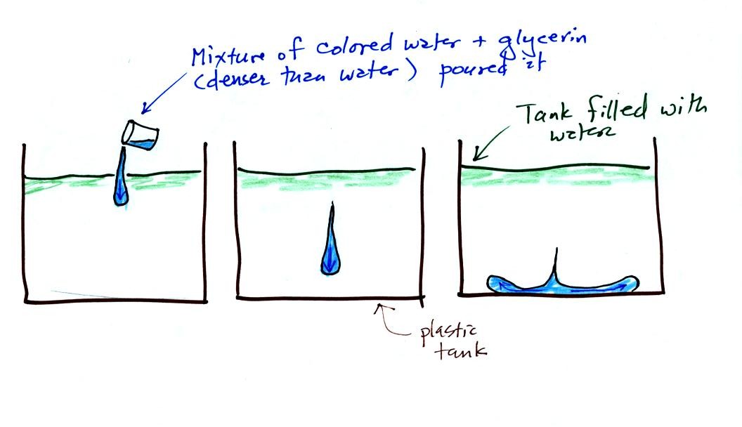
A large plastic
tank was filled
with water, the water represents air in the
atmosphere. Then a colored mixture of water and glycerin, which
is a
little denser than water, is poured into the tank. This
represents the
cold dense air in a thunderstorm downdraft. The colored liquid
sinks to
the bottom of the tank and then spreads out horizontally. In the
atmosphere the cold downdraft air hits the ground and spreads out
horizontally. These are the strong winds that can reach 100 MPH.
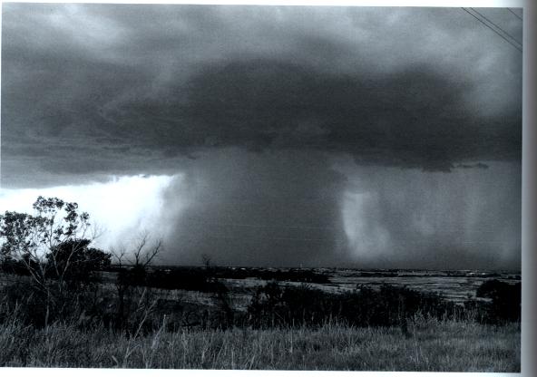
Here's
a picture of a wet microburst, a narrow intense thunderstorm downdraft
and
rain.
Here are a couple of videos from YouTube. The first
video shows a microburst from some distance away. The second video was
taken in the heavy rain and strong winds under a thunderstorm in the
microburst.
A microburst is a violent but short-lived and localized
event. A
derecho is a less known phenomenon that, like a gust front,
produces straight line winds (derecho is Spanish for "straight").
A derecho however is longer lived (30 minutes to a few hours) and can
affect a much larger area. Derecho winds are produced out ahead
of a fast moving line of thunderstorms or a mesoscale convective
system. Winds must, by definition, be greater than 58 MPH and can
exceed 100 MPH. The strong winds can be found tens to hundreds of
miles ahead of or along the advancing storm.
The figure below (source)
shows
a
shelf
cloud
forming at the front edge of an approaching
derecho. It would be hard in just a photo like this to
distinquish this from a shelf cloud
forming at the front of a normal gust front.