Wednesday Mar. 21, 2018
Music from the Brittany region (I think) in France where I used
to live and work: Digresk "Larrakia"
(4:18), Plantec "Androide"
(4:13),
Dour/Le Pottier "Avel Gorn"
(4:49), Startijenn "Strak ha pak"
(4:23), Remy Geffroy "La
Fuite du Chat Noir" (3:14)
The rain-shadow effect
Next a much more important example of drying moist air
(see p. 88 in the photocopied ClassNotes).

We start with some moist but unsaturated air (the RH is
about 50%) at Point 1 (the air and dew point temperatures would
need to be equal in order for the air to be saturated). As it is moving
toward the right the air runs into a mountain and starts to rise
(this is the 4th way of causing rising air motions). Rising
air expands and cools. Unsaturated air cools 10 C for every
kilometer of altitude gain (this is known as the dry adiabatic
lapse rate but isn't something you need to remember). So
after rising 1 km the air will cool to 10 C which is the dew
point.
The air becomes saturated at Point 2 (the air temperature and the
dew point are both 10 C). Would you be able to tell if you
were outdoors looking at the mountain? Yes, you would see a
cloud appear.
Now that the RH = 100%, the saturated air cools at a slower rate
than unsaturated air (condensation of water vapor releases latent
heat energy inside the rising volume of air, this warming partly
offsets the cooling caused by expansion). We'll use a value
of 6 C/km (an average value). The air cools from 10 C to 4 C
in next kilometer up to the top of the mountain. Because the
air is being cooled below its dew point at Point 3, some of the
water vapor will condense and fall to the ground as rain.
Moisture is being removed from the air and the value of the mixing
ratio (and the dew point temperature) decreases.
At Point 4 the air starts back down the right side of the
mountain. Sinking air is compressed and warms. As soon
as the air starts to sink and warm, the relative humidity drops
below 100% and the cloud disappears. The sinking unsaturated
air will warm at the 10 C/km rate.
At Point 5 the air ends up warmer (24 C vs 20 C) and drier (Td = 4
C vs Td = 10 C) than when it started out. The downwind side
of the mountain is referred to as a "rain shadow" because rain is
less likely there than on the upwind side of the mountain.
Rain is less likely because the air is sinking and because the air
on the downwind side is drier than it was on the upslope side.
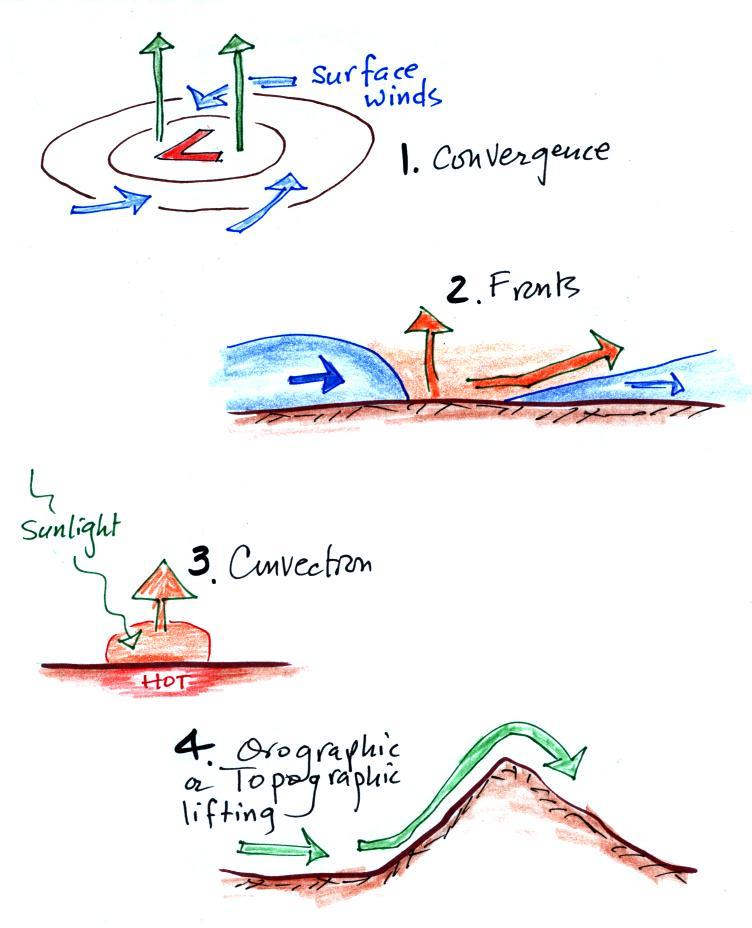
This is topographic lifting, the 4th of 4 processes that can
cause air to rise. The other three were: convergence
(surface winds spiraling inward toward a low pressure center will
rise), fronts (both warm and cold fronts cause air to rise), and
convection (warm air rises).
|
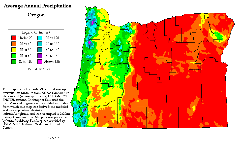 |
We can see the effects of a rain shadow illustrated
well in the state of Oregon. The figure above at left
shows the topography (here's the source
of that map). Winds generally blow from west
to east across the state.
Coming off the Pacific Ocean the winds first encounter a
coastal range of mountains. On the precipitation map
above at right (source)
you see a lot of greens and blue on the western sides of the
coastal range. These colors indicate yearly rainfall
totals that range from about 50 to more than 180 inches of
rain per year. Temperate rainforests are found in some
of these coastal locations. The line separating the
green and yellow on the left side of the precipitation map is
the summit, the ridgeline, of the coastal mountain range.
That's the Willamette River valley, I think, in between the
coastal range and the Cascades. This valley is somewhat
drier than the coast because air moving off the Pacific has
lost some of its moisture moving over the coastal range.
What moisture does remain in the air is removed as the winds
move up and over the taller Cascades. The
boundary between yellow/green and the red is the ridgeline
of the Cascade Mountains. Yearly
rainfall is generally less than 20 inches per year on the
eastern side, the rain shadow side, of the
Cascades. That's not too much more than
Tucson which averages about 12 inches of rain a year.
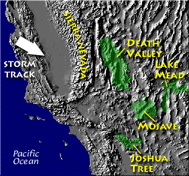
Death valley is found
on the downwind side of the Sierra Nevada mountains (source of
left image).
The Chihuahuan desert and the Sonoran
desert are found downwind of the Sierra Madre mountains in
Mexico (source
of the right image). Mexico might be a
little harder to figure out because moist air can move into the
interior of the country from the east and west at different times
of the year. It does appear that the eastern slopes of the
two mountain ranges are the wettest so much of that precipitation
must come from moist air moving in from the east (rising air
motions on the eastern mountain slopes).
Most of the year, the air that arrives in
Arizona comes from the west, from the Pacific Ocean (this
changes in the summer). It usually isn't very moist by
the time it reaches Arizona because it has traveled up and
over the Sierra Nevada mountains in California and the Sierra
Madre mountains further south in Mexico. The air loses
much of its moisture on the western slopes of those
mountains. Beginning in early July in southern
Arizona we start to get air coming from the south or
southeast. This air can be much moister and leads to
development of our summer thunderstorms.
Just as some of the world's driest regions are
found on the downwind side (the rain shadow side) of mountain
ranges, some of the wettest locations on earth are on the
upwind sides of mountains. There seems to be some debate
whether Mt.
Wai'ale'ale in Hawaii or Cherrapunji
India gets the most rain per year. Both get
between 450 and 500 inches of rain per year.
Processes that cause air to rise
You might not have noticed that while covering the rain shadow
effect we came across another process that causes rising air
motions. Rising air expands and cools. Now you
should know that if you cool moist air to its dew point, the
relative humidity increases to 100% and clouds form.
Here's a pictorial summary of the four processes that cause
rising air motions.
The newest process is called orographic or topographic
lifting.
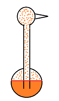
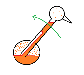
One way of measuring humidity - a sling (swing)
psychrometer
A short discussion of how you might try to measure humidity
(short because it's a topic that tends to put people to
sleep). One of the ways is to use a sling (swing is more
descriptive) psychrometer.
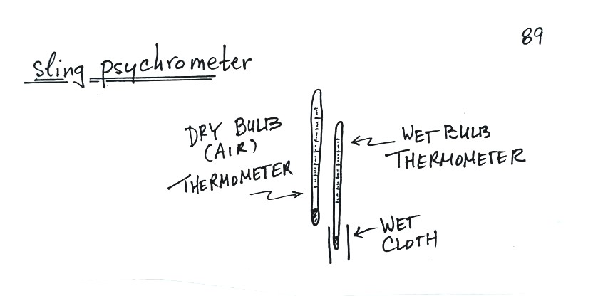
A sling
psychrometer consists of two thermometers
mounted side by side. One is an ordinary
thermometer, the other is covered with a wet
piece of cloth. To make a humidity
measurement you swing the psychrometer around
for a minute or two and then read the
temperatures from the two thermometers.
The dry thermometer measures the air
temperature.
Would the wet thermometer be warmer or colder or
the same as the dry thermometer? You
can check it out for yourself - go get one of
your hands wet. Does it feel the same as
the dry hand? You might blow on both hands
to increase the evaporation from the wet
hand. I think you'll find the wet hand
feels colder. That's what happens with the
wet bulb thermometer.
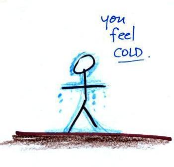
|
|
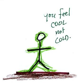
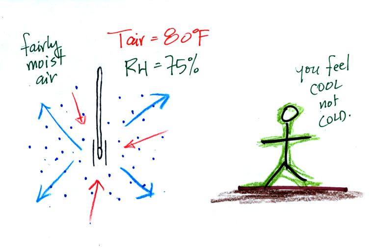
What could you say about the relative humidity in
these two situations (you can assume the air
temperature is the same in both pictures).
You would feel coldest on a dry day (the left
picture indicates dry air). The evaporative coolers
that people like me use in Tucson in the summer work much
better (more cooling) early in the summer when the air is
dry. Once the thunderstorm season begins in July and
the air is more humid it is hard to cool your house below 80
F.
You feel colder because energy is needed in order for water
to evaporate. The energy in the cases above come from
your body. When your body starts to lose energy you
feel cold.
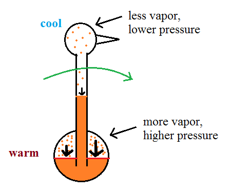
Here are a bunch of details that
you can read through if you're so inclined. My goal is
that you understand the basic principle behind a sling
psychrometer. If you'd rather not worry about the details
skip to the summary a few pictures further on.
You need to be aware of a few things to understand
the details that follow:
(1) evaporation is a cooling process
warm water evaporates more rapidly than
cold water
(2) condensation is a warming process, whenever there is
any moisture in the air there will be some condensation
the rate of condensation depends
on how much water vapor is in the air
(3) these two phenomena, evaporation and condensation,
operate independently of each other
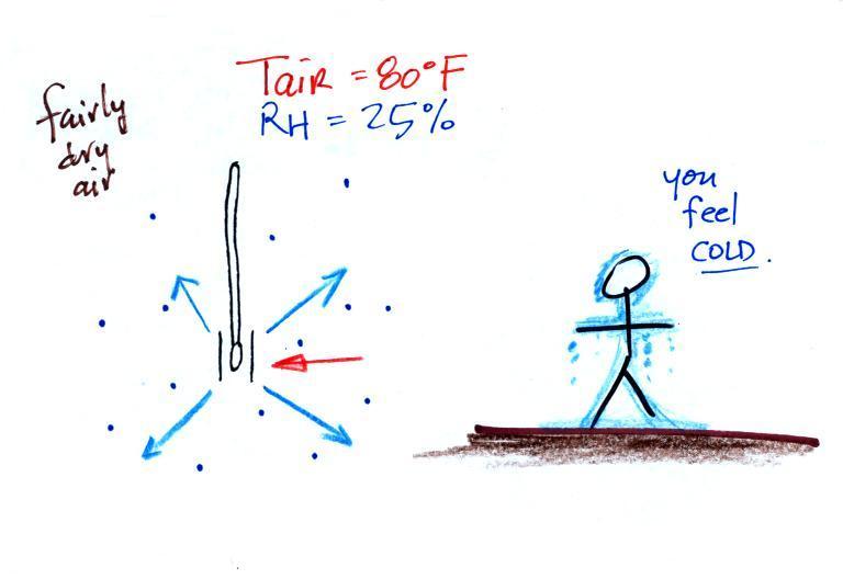
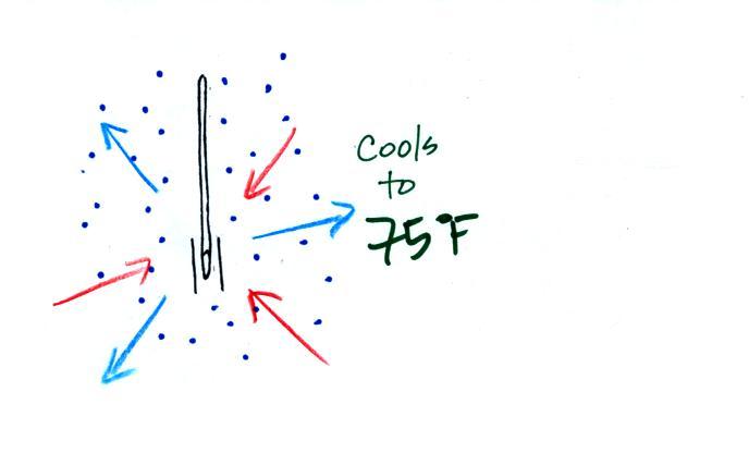
Here's the situation on a day with low relative
humidity.
The figure shows what
will happen as you start to swing the wet bulb
thermometer. Water will begin to evaporate
from the wet piece of cloth. The amount
or rate of evaporation will depend on the water
temperature Warm water
evaporates at a higher rate than cool water (think
of a steaming cup of hot tea and a glass of ice
tea).
The evaporation is shown as blue arrows because this
will cool the thermometer. The water on
the wet thermometer starts out at 80 F and
evaporates fairly rapidly.
The figure at upper left also shows one arrow of
condensation. The amount or
rate of condensation depends on how much water
vapor is in the air surrounding the
thermometer. In this case (low relative
humidity) there isn't much water vapor. The
condensation arrow is orange because the
condensation will release latent heat and warm the
thermometer.
Because there
is more evaporation (4 arrows) than
condensation (1 arrow) the wet bulb
thermometer will drop. As the
thermometer cools the rate of evaporation
will decrease. The thermometer will
continue to cool until the evaporation has
decreased enough that it balances the
condensation.
The
rates of
evaporation
and
condensation
are
equal.
The
temperature
will now
remain
constant.
The
figure below
shows the
situation on a
day with
higher
relative
humidity.
There's
enough
moisture in
the air to
provide 3
arrows of
condensation.
The rate of evaporation stays the same, the
rate of condensation is higher. The rate of
evaporation is still higher than condensation but not by
much.
There'll
only be a little cooling before the
evaporation is reduced enough to be in
balance with condensation.
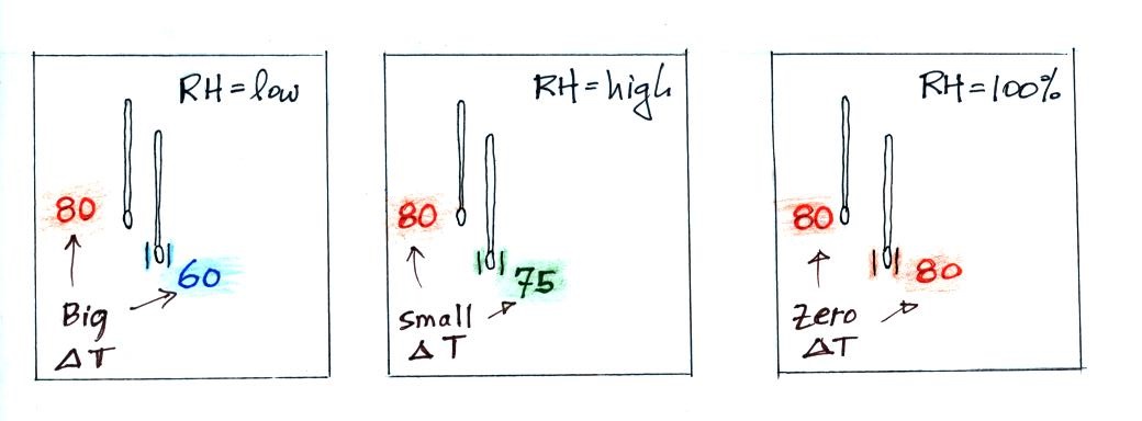
A large difference between the
dry and wet temperatures means the relative humidity
is low. A
small difference means the RH is higher. No
difference means the relative humidity is
100%.
We saw the same kind of relationship between RH and the
difference between air and dew point temperature.
Wind chill and heat index
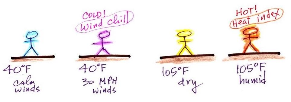
Cold temperatures and wind make it feel
colder than it really is. The wind
chill temperature tells you how much colder it will feel (
a thermometer would measure the same temperature on both the
calm and the windy day). If your body isn't able to keep
up with the heat loss, you can get hypothermia
and die.
There's something like that involving heat
and humidity. High temperature and high humidity makes it
feel hotter than it really is. Your body tries to stay
cool by perspiring. You would feel hot on a dry 105 F
day. You'll feel even hotter on a 105 F day with high
relative humidity because your sweat
won't evaporate as quickly.
The heat
index measures how much hotter you'd feel. The combination
of heat and high humidity is a serious, potentially deadly,
weather hazard because it can cause heatstroke
(hyperthermia). A thermometer would
measure the same 105 F temperature on both a dry and a humid
day.
The drinking bird
Evaporative cooling and the dependence of saturation mixing
ratio on temperature are both involved in the "drinking
bird".
I'm very proud of the bird I found
online. It is about twice as big as what you
normally find. The bird is filled with a volatile
liquid of some kind (ether?). Initially the bird's
head and tail are the same temperature. The liquid
inside the bird evaporates and saturates the
air inside with vapor.
Next you get the bird's head wet. Instead of water I
cheat a little bit and use isopropyl alcohol (rubbing
alcohol) because it evaporates more rapidly than
water. The evaporation of alcohol, just as with water,
cools the bird's head.
As we saw last week, the saturation mixing ratio
(saturation vapor concentration) of water depends on
temperature. Warm air can contain more water vapor
than colder air. The same applies to the ether
vapor in this case. The head is still saturated
with vapor but there is less vapor in the cool head than
there is in warm saturated air in the bird's tail.
The differences in amounts of vapor
produce pressure differences. The higher pressure
at the bottom pushes liquid up the stem of the
bird. The bird becomes top heavy and starts to
tip.
At some point the bottom end of the stem comes out of
the pool of liquid at the base. Liquid drains from
the neck and the bird straightens up.
You can arrange the bird so that when it tips its beak dips
into a small cup of water (or alcohol). This keeps the
head moist and cool and the dipping motion could go on
indefinitely. Here's a
video.
We took away the bird's supply of alcohol, the bird warmed up
and stopped tipping.

