Friday Apr. 4, 2008
The Experiment #4 reports are due next
Monday. I haven't been
real good about pestering you to return the materials and pick up the
supplementary information sheet so I will allow you to turn in your
report next Wednesday, provided you return the materials next Monday or
Tuesday.
I had intended to handout solutions to the humidity Optional Assignment
(the assignments themselves will be returned on Monday) but
forgot. I'll have them on Monday. If you are in a hurry to
see them here's a scanned image of page 1 and page 2.
Here is the answer
to the question.
Warning
Today's class did include behavior
that some people probably found objectionable.
But it sure brought people back to life for a short period of time.
Here's a quick review of what we had just started at the end of
Wednesday's class dealing with the formation of precipitation in clouds.
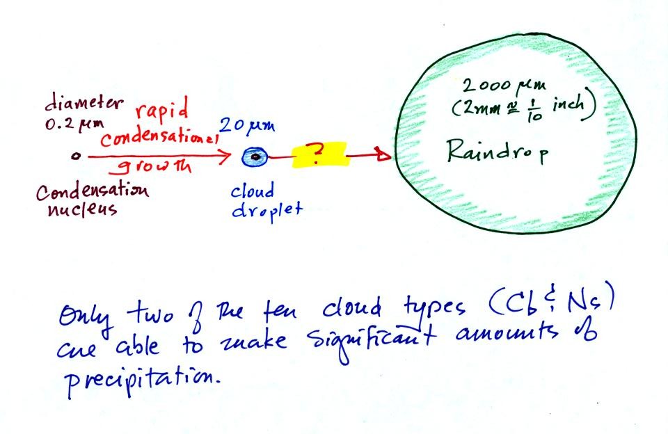
This figure shows typical sizes of cloud
condensation nuclei (CCN), cloud droplets, and raindrops (a human hair
is about 50 um thick for comparison). As we
saw in the cloud in a bottle demonstration it is relatively easy to
make cloud droplets. You cool moist air to the dew point and
raise the RH to 100%. Water vapor
condenses pretty much instantaneously onto a cloud condensation nucleus
to form a cloud droplet. It
would take much longer (a day or more) for condensation to turn a cloud
droplet
into a
raindrop. You know from personal experience that once a cloud
forms you don't have to wait that long for precipitation to begin to
fall.
The basic problem is that a typical raindrop contains
about 1 million cloud droplets.
Below are the two processes capable of quickly turning cloud droplets
into much larger precipitation particles.
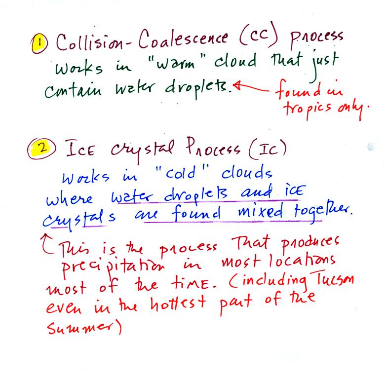
The collision coalescence process works in clouds that
are
composed of water droplets only. Clouds like this are only found
in
the tropics. We'll see that this is a pretty easy process to
understand. This process will only produce rain.
The ice crystal process produces precipitation everywhere else.
This is the process that makes rain in
Tucson, even on the hottest day in the summer. There is one part
of this process that is a little harder to understand. This
process can produce a variety of different kinds of precipitation
particles (rain, snow, hail, etc).
Here's
what you might see if you looked inside a warm cloud with just water
droplets:
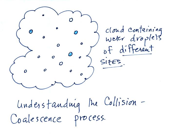
The collision coalescence process works best in a cloud
filled with cloud droplets of different sizes. As we saw in a
short video the larger droplets fall
faster than the small droplets. A larger than average cloud
droplet will overtake and collide with smaller slower moving
ones.
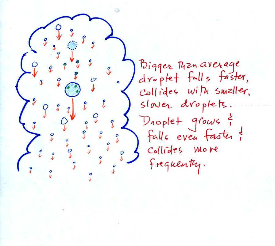
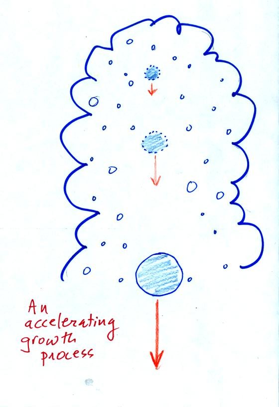
This is an acclerating growth process. The
falling droplet
gets
wider, falls faster, and sweeps out an increasingly larger volume
inside the cloud. The bigger the droplet gets the faster it
starts to grow.
The figure
below shows the two precipitation producing clouds:
nimbostratus (Ns) and cumulonimbus (Cb). Ns clouds are thinner
and have weaker updrafts than Cb clouds. The largest raindrops
fall from Cb clouds because the droplets spend more time in the cloud
growing.
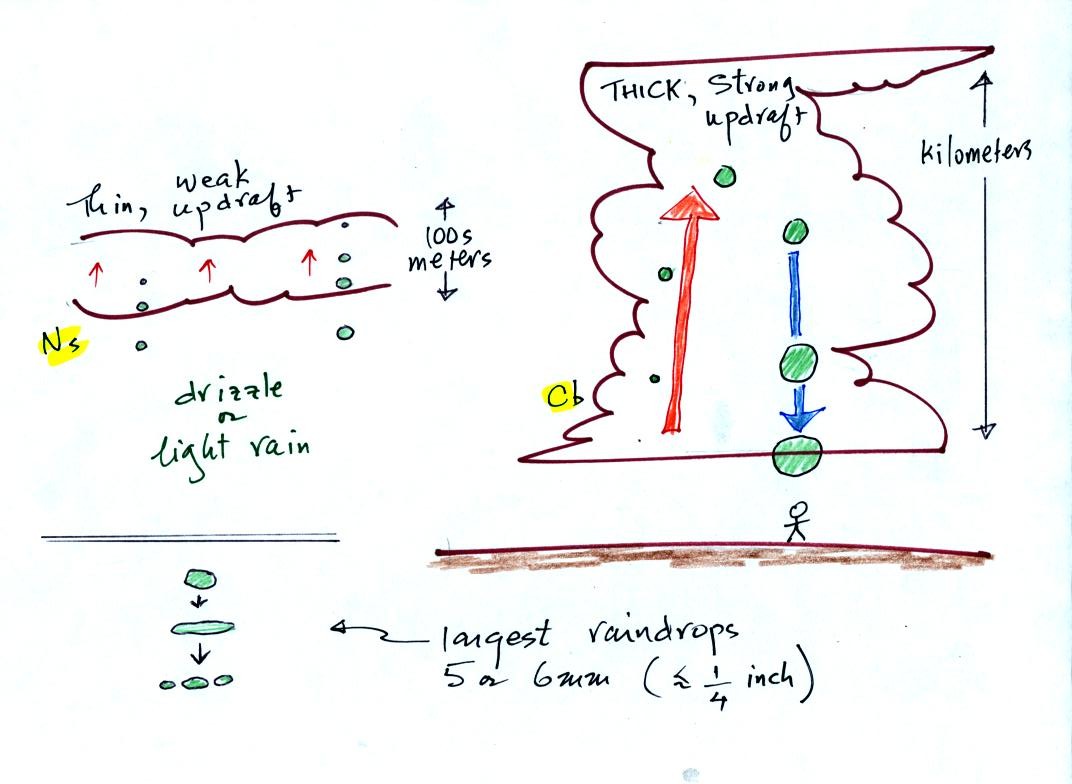
Raindrops grow up to about 1/4 inch in diameter.
When
drops get
larger than that, wind resistance flattens out the drop as it falls
toward the ground. The drop begins to "flop" around and breaks
apart
into several smaller droplets. Solid precipitation particles such
as hail can get much larger than 1/4 inch in diameter.
Before
learning about the second precipitation producing process, the ice
crystal process, we need to look at the structure of cold clouds.
The figure below is a redrawn version of what was drawn in class
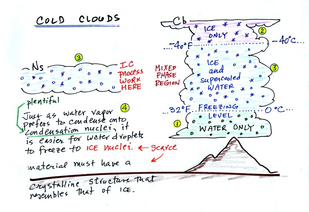
The bottom of the thunderstorm, Point 1, is warm
enough
(warmer than freezing) to just
contain water
droplets. The top of the thunderstorm, Point 2, is colder than
-40 C and just contains ice crystals. The interesting part of the
thunderstorm and the
nimbostratus cloud is the middle part, Point 3, that contains both
supercooled water
droplets (water that has
been cooled to below freezing but hasn't frozen) and ice
crystals.
This is called the mixed phase
region. This is where the ice crystal process will be able
to produce
precipitation. This is also where the electrical charge that
results in lightning is generated.
The supercooled water droplets aren't able to freeze even though
they
have been cooled below freezing. At Point 4 we see this is
because it is much
easier for small droplets of water to freeze onto an ice crystal
nucleus or for water vapor to be deposited onto an ice crystal nucleus
(just like it is easier for water vapor to condense onto
condensation nuclei rather than condensing and forming a small droplet
of pure water). Not just any material will work as an ice nucleus
however. The material must have
a crystalline structure that is like that of ice.
We'll see
next how the ice crystal process works. There are a couple of
"tricky" parts.
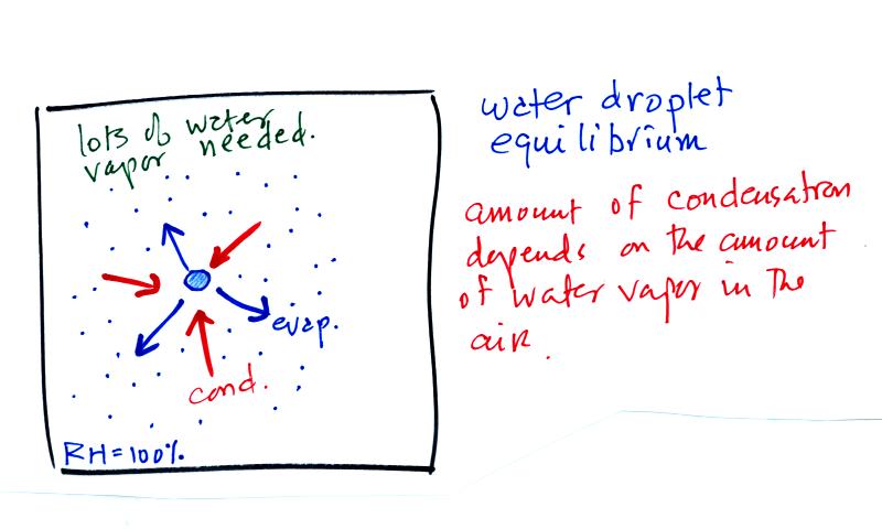
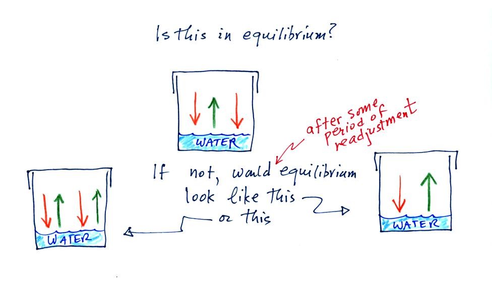
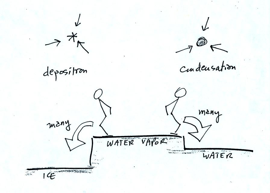
The first figure above (see p.101 in the photocopied Class
Notes)
shows a water droplet in equilibrium with its surroundings..The droplet
is evaporating (the 3 blue arrows in the figure). The rate of
evaporation will depend on the temperature of the water droplet.
The droplet is surrounded by air that is saturated with water vapor
(the droplet is inside a cloud where the relative humidity is
100%). This means there is enough water vapor to be able to
supply 3 arrows of condensation.
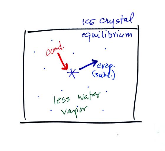
This figure shows what is required for an ice crystal (at
the same
temperature) to be in equilibrium with its surroundings. First
the ice crystal won't evaporate as rapidly as the water droplet (only
one arrow is shown). Going from ice to water vapor is a bigger
jump than going from water to water vapor. There won't be as many
ice molecules with enough energy to make that jump. A sort of
analogous situation is shown in the figure below. The class
instructor was, after a fair amount of practice over the past couple of
days, able to jump from the ground up 20 inches and land on a
chair (a swivelling chair with wheels). But he wasn't willing (he
was pretty he wouldn't be able) to jump from the floor up 34
inches and land on the top of the cabinet near the front of the room
(that cabinet also has wheels, by the way).
To be in equilibrium only one arrow of condensation is
needed.
There doesn't need to be as much water vapor in the air surrounding the
ice crystal to supply this lower rate of condensation.
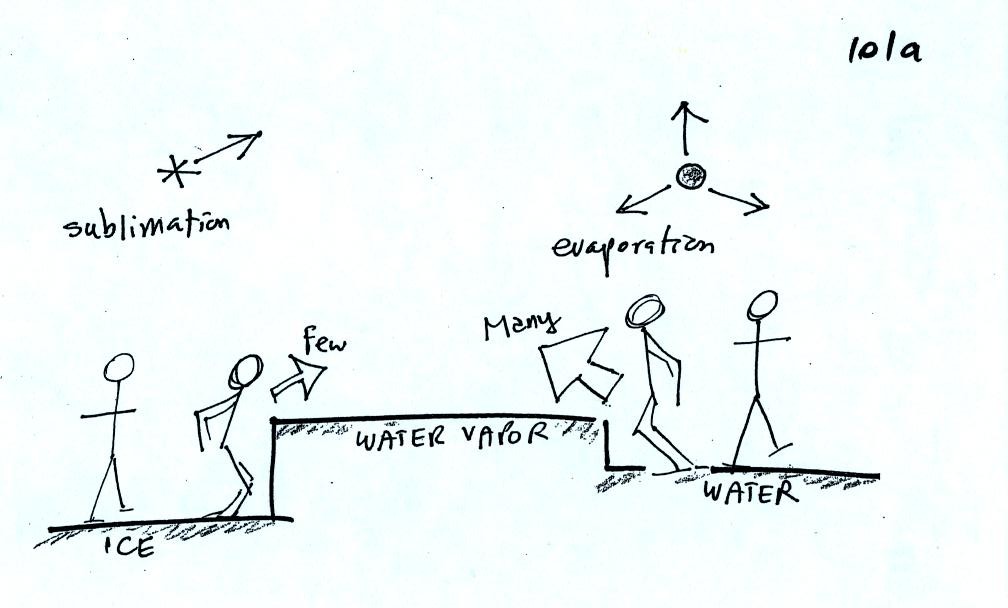
There are going to be fewer people able to make the
big jump on
the
left just as there are fewer ice molecules able to sublimate.
Going from water to water vapor is a "smaller jump" and more molecules
are able to do just as more people would be able to make the shorter
jump at right in the picture above.
Now what happens in the mixed phase region of a cold cloud
is that
ice crystals find themselves in the very moist surroundings needed for
water droplet equilibrium. This is shown below.
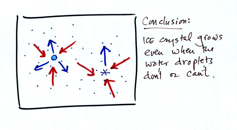
The water droplet is in equilibrium (3 arrows of evaporation
and 3
arrows of condensation) with the surroundings. The ice crystal is
evaporating more slowly than the water droplet. Because the ice
crystal is in the same surroundings as the water droplet water vapor
will be condensing onto the ice crystal at the same rate as onto the
water droplet. The ice
crystal isn't in equilibrium, condensation
exceeds evaporation and the ice crystal will grow. That's
what makes the ice crystal process work.
The equal rates of condensation are shown in the figure
below using the
earlier analogy.
Even though he wasnt ableto jump from the floor to the cabinet top,
the instructor had no problem jumping from the cabinet top to the floor.
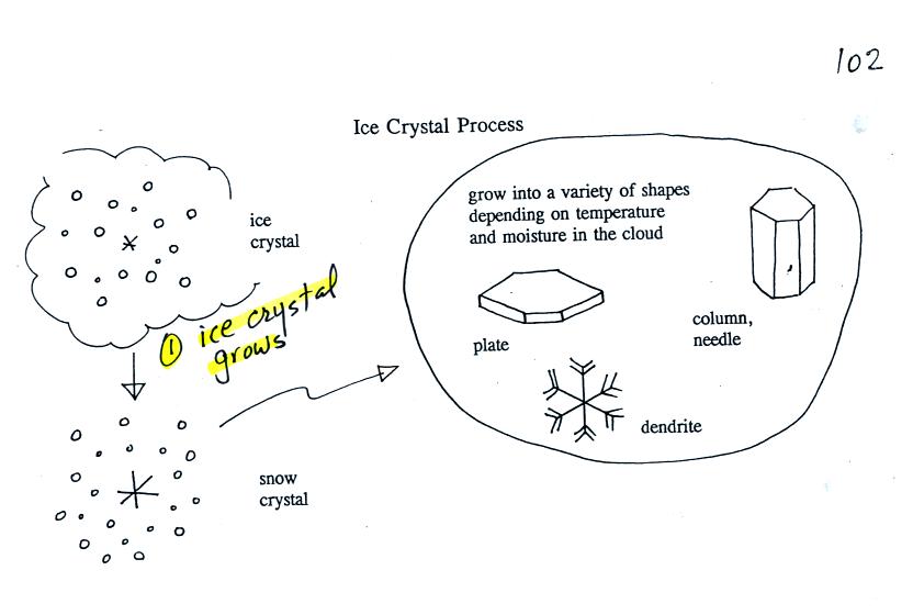
Once an ice crystal has grown a little bit it becomes a snow
crystal (this figure is on p. 102 in the photocopied classnotes).
Snow crystals can have a variety of shapes (called
crystal habits) depending on the conditions
(temperature and moisture) in the cloud. Dendrites are the most
common because they form where there is the most moisture available for
growth. With more raw material available it makes sense there
would be more of this particular snow crystal shape.
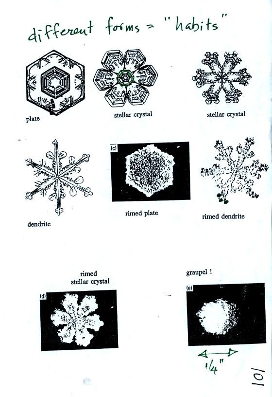
Here are some actual photographs of snow crystals (taken
with a
microscope). Snow crystals are usually about 100 or a few 100s of
micrometers in diameter (tenths of a millimeter in diameter). You
would need to look through a microscope to be able to seem these
different shapes.
You'll find some much better photographs
here
and here
and here.
You'll also find a
chart with sketches and names of different ice crystal
habits. Much more information can be found at www.snowcrystals.com
That
was it for Friday's class. Have a nice weekend.