April 7, 2008
Hurricanes (Continued)
n Last time we went through a simplified model for hurricane development that was meant to explain energetically how hurricanes strengthen. However, that model does not explain the actual way these tropical systems organize. This is described below.
n Anatomy of a real hurricane
o As with any cyclone, winds at the surface blow generally counterclockwise (in the Northern Hemisphere), and converge toward the low center (spiral inward).
o Draw a top-down figure of a typical hurricane.
§ Look at figure 11.2 (textbook)
o All hurricanes consist of the following components:
§ Surface low: All tropical cyclones rotate around an area of low atmospheric pressure near the Earth's surface. The pressures recorded at the centers of tropical cyclones are among the lowest that ever occur at sea level.
§ Warm core: Tropical cyclones are characterized and driven by the release of large amounts of latent heat of condensation as moist air is carried upwards and its water vapor condenses. This heat is distributed vertically, around the center of the storm. Thus, at any given altitude (except close to the surface where water temperature dictates air temperature) the environment inside the cyclone is warmer than its outer surroundings.
§ Eye: A strong tropical cyclone will harbor an area of sinking air at the center of circulation. Weather in the eye is normally calm and free of clouds (however, the sea may be extremely violent). The eye is normally circular in shape, and may range in size from 8 km to 200 km (5 miles to 125 miles) in diameter. In weaker cyclones, the clouds may cover the circulation center, resulting in no visible eye.
· The abnormally high pressure found at the top of the storm (above the eye) plays a role in initiating the downward air motion within the eye.
§ Eyewall: The eyewall is a circular band of intense convection and winds immediately surrounding the eye. It has the most severe conditions in a tropical cyclone. Intense cyclones show eyewall replacement cycles, in which outer eye walls form to replace inner ones. The mechanisms that make this occur are still not fully understood. In the eyewall replacement process, the eyewall contracts to a smaller size, and outer rain bands form a new eyewall. This new eyewall weakens the original one, and eventually replaces it completely. During the replacement cycle, the storm weakens, sometimes dramatically, but afterwards the storm will often be stronger than before.
§ Outer or Spiral Rain Bands: Focused areas of low level convergence, rising motion, and heavy rain that rotate counterclockwise around the storm. These may extend hundreds of kilometers from the storm's center. The spiral rain bands are basically aligned with the low level winds which rotate counterclockwise and spiral inward toward the storm's center.
§ Outflow: The upper levels of a tropical cyclone feature winds headed away from the center of the storm with an anticyclonic (clockwise) rotation. Winds at the surface are strongly cyclonic, weaken with height, and eventually reverse themselves. Tropical cyclones owe this unique characteristic to the warm core at the center of the storm.
§
Examine
figure 11.3 from the textbook.
n
Tropical
Storm / Hurricane Occurrence
o Worldwide, 86 tropical cyclones reach tropical storm strength each year on average. Of these, 47 reach hurricane strength with 20 of those being major hurricanes (category 3 or higher).
§
Figure 11.10 shows that tropical storms form in
all of the tropical ocean basins, except the south
o The table below shows statistics for the 5 most active ocean basins
|
Basin |
Season Start |
Season End |
Tropical Storms |
Hurricanes |
Major Hurricanes |
|
Northwest Pacific |
Year round |
Year round |
26.7 |
16.9 |
8.5 |
|
Northeast Pacific |
May |
November |
16.3 |
9.0 |
4.1 |
|
Southwest Indian |
October |
May |
13.3 |
6.7 |
2.7 |
|
|
June |
November |
10.6 |
5.9 |
2.0 |
|
Southwest Pacific |
October |
May |
10.6 |
4.8 |
1.9 |
n
Hurricane
Movement
o The
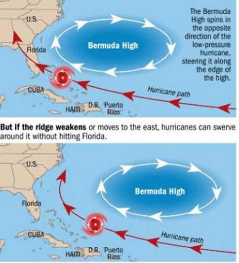
most important determinant of hurricane movement is the large-scale
environmental air flow in the middle troposphere in the vicinity of the storm.
In other words, hurricanes tend to be "steered" around by the winds
blowing at about 500 mb pressure. In late summer and
early fall the "typical" wind patterns at 500 mb
are generally easterly (or east toward west) below or south of 30° latitude and
westerly (west toward east) above or north of 30° latitude. The reason for this
is that a broad and elongated area of higher pressure is typically found near
30° latitude. Hurricanes to the south 30° latitude will generally be steered
from east to west. However, as shown in
figure 11.10, hurricanes have a tendency to turn away from the equator
(toward the north in the Northern Hemisphere) at some point along their track.
o Overview
for Atlantic hurricanes moving into the
§
The subtropical high pressure area over the

§
The areas of the
o Overview
for Pacific Hurricanes moving into the
§
Although the west coast of the
n
Predicting
Hurricane movement and Intensity.
Providing public warnings.
o The
previous sections of these notes may lead you to conclude that predicting
hurricane movement is easy, just look at the 500 mb
winds, but this is misleading. The
actual path taken by a hurricane can be caotic and
difficult to predict. One difficulty lies in the fact that the upper level
winds that can steer hurricanes (pressure levels at 500 mb
and higher altitudes) are often quite weak in the tropics. When steering winds are weak, the actual path
of a hurricane is determined by the structure of the storm and the storm's
interaction with the environment, which is difficult to determine. Thus, it is not all that uncommon for
hurricanes to take erratic paths and make odd turns that catch weather
forecasters by surprise.
§
Take a
look at link showing track of all Atlantic hurricanes (1851-2006).
o Hurricane
forecasters must predict:
§
Storm movement (future storm positions)
§
Future storm intensity (usually the more
difficult of the two)
o The
§
Show
figure linked on the lecture summary page.
§
Notice though that on average there are still
significant errors in the prediction of the future position of hurricanes.
o A
more challenging problem is to predict the future intensity of hurricanes, that
is will they strengthen or weaken and how fast will these changes occur. The
problem here is caused by both by our lack of understanding of hurricane
evolution which results in poor computer modeling as well as the lack of
observations or measurements near the storm's center, which are necessary to
understand exactly what is happening.
§
The big problem is pointed out by Max Mayfield,
former director of the National Hurricane Center -- "Most major
hurricanes become major hurricanes by going through some rapid intensification
cycle that we just don't understand ..." This sets up the possibility
of what Mayfield calls his "nightmare scenario" -- where for example,
a rather weak hurricane just off the coast rapidly intensifies to a major
hurricane overnight, and slams into a coastal region where the population is
unprepared. "We still haven't had that nightmare scenario where people go
to bed prepared for a Category 1 hurricane and wake up to a Category 4,"
Mayfield says. "That's going to
happen one of these days, and it's going to be devastating."
o With
modern techniques of forecasting and tracking hurricane paths, it is always
possible to issue warnings about the "probable" locations that will
be affected by any given hurricane. Although hurricanes can be easily tracked
using satellite data, predictions of their future movement and intensity are by
no means certain. Based on the estimated uncertainty in future hurricane
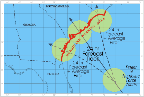
movement, hurricane watches and warnings are issued for a wide swath as shown
in the figure below.

§ The large warning area follows the motto “better safe than sorry”. But it does present a problem. Suppose a large area is evacuated, but the actual hurricane only affects a portion of the warning area. People who evacuated from areas not severely affected by the hurricane may choose to ignore the warning next time … thinking the forecaster have no idea what they are doing.
§ Hurricane Watch: An announcement of specific coastal areas that a hurricane or an incipient hurricane condition (sustained winds > 74 mph) poses a possible threat, generally within 36 hours.
§ Hurricane Warning: Sustained winds of 74 mph or greater associated with a hurricane are expected (have a good probability of happening) in a specified coastal area in 24 hours or less.
n
Destruction
at Landfall
o Although
we usually categorize hurricanes in terms of their wind speed, coastal flooding
due to what is called the storm
surge often causes the most damage.
Most of the spectacular damage done by hurricanes, e.g., buildings,
houses, marinas, piers, etc., completely destroyed or even removed from where
they were standing is due to the storm surge.
o
A storm surge is the rise in sea level
along the coast as onshore winds pile up the water. It is more like a big dome of water that can
be over 100 km in width, rather than big waves.
It is similar to tsunamis in that it is a large mass of water, which is
forced onshore. As the moving water
encounters the normally shallower water areas near the shore, it is forced to
rise upward. Storm surges are measured
in feet above normal sea level (see Saffir-Simpson scale).
Water is very heavy and damaging, and can “wash away” entire houses and
bridges.
§
The damage potential associated with a storm
surge depends upon:
1. The
strength of the wind … stronger winds, higher surge
2. The
slope of the Earth’s surface near the shoreline
o
If more gradual, water can move further
inland. Thus some areas are more
vulnerable than others. Draw simple picture.
3. Timing
with respect to normal high and low tides.
o
High tides add to the storm surge
o
In the Northern Hemisphere, the greatest storm
surge and the strongest winds occur to the right of the storm center with
respect to the direction that the storm is moving as it makes landfall.
§
A diagram
explaining this will be drawn in lecture.
o
High winds also cause considerable damage.
Hurricane strength winds can damage or destroy vehicles, buildings, bridges,
etc. High winds also turn loose debris into flying projectiles, making the
outdoor environment even more dangerous. As hurricanes come in many sizes, the
area covered by hurricane force winds is a factor in the total amount of damage
done. For example, not only was Katrina a very powerful storm, it was also a
very large storm.
o
Flooding is also caused by the heavy rains
associated with hurricanes, especially when a slow moving or nearly stationary
hurricane sits just offshore causing a prolonged period of heavy rains over
nearby coastal areas. This can be especially problematic if the nearby coast
has sharply rising mountains, enhancing the heavy rains by orographic
lifting, with the runoff causing landslides.
o
Considerable damage may also occur from
hurricane-spawned tornadoes that may form as the hurricane interacts with land
areas. About one-quarter of them produce significant numbers of tornadoes.
Tornadoes are most likely to develop in the right front quadrant of the storm,
and are more likely to be associated with a spiral rain band rather than the
storm's center. They result from the vertical wind shear present in the lower
levels of the hurricane's circulation. Most hurricane-spawned tornadoes are of
the weak variety (compared to the monsters that can form over the great plains
of the