March 28, 2008
Quickly go over last two items for lightning
n
Lightning detection network
o Cloud-to-ground
that has already occurred can be located using an instrument called a lightning
direction-finder, which works by detecting the radio waves produced by lightning.
A network of these magnetic devices has been set up all around the
§
Draw a
simple diagram for this.
o This
information is often displayed on maps showing the time and location of all
detected cloud to ground lightning strikes (see link on the lecture summary
page). This is valuable in showing the general motion of lightning producing
storms and the density of lightning strikes, but it can not be used to predict
when and where a newly developing storm will first produce lightning.
n
Lightning prediction and warning
o The
liklihood that cloud to ground lighting is about to
occur is estimated by measuring the electric field build up in the air. The
Electric Field is a measure of the strength of the charge build up. When a
certain threshold is reached, lightning is about to hit somewhere. Electric
field measuring equipment is used at many outdoor events (e.g., golf
tournaments, state fairs, etc.) to allow authorities to give warning that
people should take cover. Note that while the electric field instrumentation
can provide information that tells us lightning is about to strike somewhere in
the area, there is no way to predict exactly where the lightning will hit.
§
Again
draw a simple diagram for this.
Distribution of thunderstorms
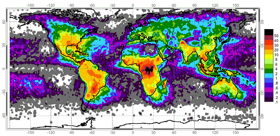
n It is estimated that more than 50,000 thunderstorms occur each day throughout the world. Annually this adds up to more than 18 million thunderstorms per year.

n
The figure above shows the distribution of
world-wide lightning strikes from satellite-based optical sensors. Units are #
of flashes per square kilometer per year.
Thunderstorms form from the equator to as far north as
n
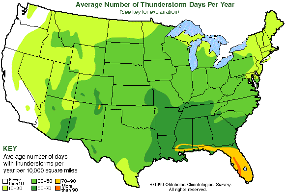
The figure below describes the annual average
number of thunderstorm days across the

n
Although the tropical regions experience the
highest number of thunderstorms per year, severe thunderstorms occur most
frequently in the humid subtropics. The most severe thunderstorms in the world
occur in the

Tornadoes
n A tornado is a rapidly rotating column of air that blows around a small area of intensely low pressure and is in contact with both the cloud base and the surface of the Earth. In exceptionally strong tornadoes, wind speeds can be over 300 mi/hr.
n No other weather phenomenon can match the fury and destructive power of tornadoes. They can destroy large buildings, leaving only the bare concrete foundation, lift 20-ton railroad cars from their tracks, or drive straw and blades of grass into trees and telephone poles.
n Most “classic” tornadoes that cause moderate to heavy damage are associated with supercell thunderstorms. We will concentrate on these types of tornadoes. The information concerning the typical tornado lifecycle and formation provided in this lecture does not explain many of the smaller and weaker tornadoes, such as waterspouts, landspouts, and gustnadoes. It does not explain some of the more rare tornadoes, such as multiple vortex tornadoes or satellite tornadoes. It also does not explain some of the more powerful tornadoes that are able to last for hours. These types of tornadoes have different mechanisms that influence their development. In all cases, there is still quite a bit that is not understood about tornadoes and tornado formation.
n Lifecycle of a classic supercell tornado
o Supercell thunderstorms develop in a region of strong vertical wind shear. Vertical wind shear can cause air to rotate about a horizontal axis. A tube of rotating air is often called a vortex tube or simple a vortex.
§ See figure 10.34a.
§ Speed shear alone can also cause a vortex to form
o A strong updraft then tilts this rotating tube upward so that the rotation is now about a vertical axis. This causes the updraft to rotate counterclockwise as it rises.
§ See figure 10.34b.
o At this point the vortex is much larger than a tornado with a diameter of 5 – 10 km. The rotation of the updraft lowers the air pressure in the middle levels of the thunderstorm. When this occurs, updraft speeds will increase further because the circulation can force air to accelerate upward even at altitudes below where the rising parcels become buoyant.
o This 5 – 10 km wide counterclockwise circulation around lower pressure is called a mesocyclone (literally a medium-sized cyclone). This is when the first stage of development of the tornado life cycle, the dust-whirl stage, may be observed.
§ Near the ground, dust may be seen swirling upward, while a wall cloud may be seen hanging below the rest of the cloud base. The wall cloud is actually caused by condensation in the rising updraft and provide a “visualization” of the rotating updraft.
· See figures 10.35 and 10.38
o Next the storm’s precipitation begins to wrap around the rotating mesocyclone. This forms the classic hook echo on RADAR displays.
§ See figures 10.35 and 10.36
o Downdrafts develop in the falling precipitation. When conditions are just right, the rear flank downdraft is able to drag the mesocyclone circulation downward toward the ground. As a vortex is stretched vertically, its diameter decreases and it is forced to spin faster by the physical law of conservation of angular momentum. (This is the same principle that ice skaters use to increase their spin speed by pulling in their arms.) Note that the interaction between the rotating updrafts and rear flank downdrafts are much more complex than described above.
o A funnel cloud can now be seen descending from the wall cloud. In tornado-producing supercells, the wall cloud is often observed 10-20 minutes before the tornado touches down, but it may be less than one minute or more than an hour.
o Once the vortex is stretched to the ground, we have a tornado. This is the mature stage of the tornado life cycle, when it is most powerful and destructive. The tornado is often nearly vertical in this stage.
§ See figure 10.27
o As the tornado weakens, probably because cold downdraft air completely encircles the updraft cutting off the energy supply of warm, humid air, the width of the funnel usually shrinks and becomes more tilted. In the final stage of a tornado life cycle, the decay stage, the tornado is often shaped like a contorted rope before fully dissipating.
§ Show video clip of life cycle of an actual tornado
n Tornado Occurrence
o Because
tornadoes form in conjunction with severe thunderstorms, especially supercells, more tornadoes occur in the
o Perhaps
surprisingly, central
§ See tornado occurrence figures linked on the lecture notes page.
n
Tornado Statistics and Characteristics for the
o Tornadoes
kill an average of about 60 people each year in the
o In
the late 1960s, the late Dr. T. Theodore Fujita, a noted authority on tornadoes
at the
§ Go over the link to the EF scale.
o Below is a table summarizing some of the characteristics of tornadoes
|
Characteristic |
Most Common |
Extreme / Possible |
|
Location on Earth |
|
Almost anywhere |
|
Time of year (US) |
March – July (figure 10.29) |
Anytime of year |
|
Time of day |
Late afternoon (4 – 6 PM) |
Anytime of day |
|
Size (diameter) |
50 yards |
> 1 mile |
|
Movement-Speed (US) |
30 mph |
0 – 70 mph |
|
Movement-Direction (US) |
Toward the northeast |
Any direction |
|
Length of ground path |
< 2 miles |
> 300 miles |
|
Time on Ground |
< 5 minutes |
> 6 hours |
|
Wind speed |
< 100 mph (EF0, EF1) |
> 300 mph |
n Tornado Safety
o Most tornado-related deaths and injuries are caused by flying debris, so the most important consideration is to shelter yourself from flying debris. If possible go to a sturdy structure. Your best bet is to move into a basement or underground storm shelter. If these are not available go to an interior closet away from windows. Cars and mobile homes are not sturdy structures and are dangerous locations to wait out a tornado. If you are caught outside, you want to get as low to the ground as possible. Your best bet is to lie flat in a ditch or depression in the ground.
§ In recent years about 45% of all US tornado fatalities happened in mobile homes.
o When
meteorologists at the
o Tornadoes come and go so quickly and are so small that predicting where and when one will hit more than 15 to 30 minutes ahead of time is not possible. The average warning time for a tornado with winds of 158 miles an hour or faster - the type that accounts for most deaths - is 18 minutes. Tornado warnings are issued by local weather offices once a tornado is spotted visually (by a trained spotter) or detected on a RADAR screen.
§ Recall that a hook echo on a conventional RADAR screen often indicates that where a tornado is about to form.
§ Tornadoes can be detected with Doppler RADAR and when they are, tornado warnings are issued. All weather radars work by measuring the reflected (or more correctly backscattered) radiation coming from large particles such as raindrops and hail. Doppler radars can also detect whether the reflecting particles are moving toward or away from the radar site. Thus, the rotating winds around a tornado can show up very well on Doppler Radars. Sometimes the rotation can be observed at cloud level, and a tornado warning issued, before the tornado circulation touches down on the ground.
n Another quick look at tornado alley
o Time permitting, we will briefly discuss the information provided on the assigned reading page (tornado alley) and the embedded “convection cap” link to point out a few more reasons why this area is the most favored area on Earth for the development of monster tornadoes.
End of Quiz 4 Material