Thursday Apr. 17
The Quiz #4 Study Guide is now available in very
preliminary form.
Here are some of the pictures that
people drew on the back side of the Optional Assignment handed out in
the MWF class on Monday together with some comments. I hope
you enjoy
them, I did. And here is a
sample of some of the pictures from the T Th class (I didn't include
all of them, there were too many)
The sprint
finish at the end of the final stage of the 2007 Tour de France was shown before
the
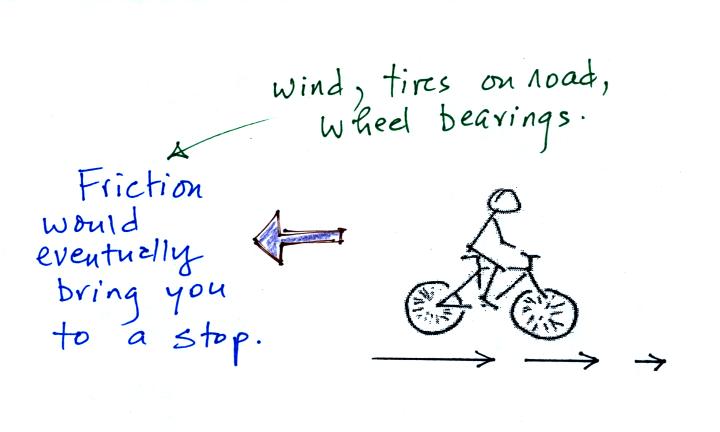
start of class. I don't know for sure how fast the racers are
riding at the finish, 40 MPH maybe more. It takes a lot of effort
to ride your bicycle that fast. If you stopped pedaling you would
quickly slow down. That is because the force of friction is
always acting against you.

At speeds of 40 MPH friction is due primarily to wind resistance
(imagine what you would feel standing outside in a 40 MPH wind).
An
ordinary air mass thunderstorm in its mature stage is shown below.

The downdraft will spread throughout the interior of the cloud
and eventually interfere with the updraft. That will cause the
storm to weaken and dissipate. Next we will see how one small
change in atmospheric conditions can create a storm that will last
longer, and grow bigger and stronger.

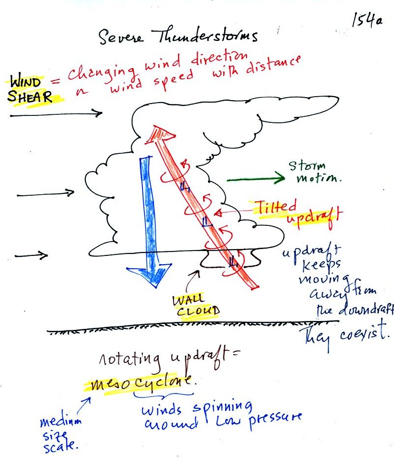
The winds are increasing in speed with increasing
altitude in the figure above. This is vertical wind shear
(changing wind direction
with altitude is also wind shear).
The thunderstorm will move to the right more
rapidly than the air in the thunderstorm updraft which originates at
the ground. Rising air that is situated at the front bottom edge
of the thunderstorm will find itself at the back edge of the storm when
it reaches the top of the cloud. This produces a tilted
updraft.
Remember that an ordinary air mass thunderstorm will begin to dissipate
when the downdraft grows horizontally and cuts off the updraft.
In a severe storm the updraft is continually
moving to the right and staying out of the downdraft's way.
Severe thunderstorms can get bigger, stronger, and last longer than
ordinary air mass thunderstorms. The strong updraft winds can
keep hailstones in the cloud longer which will allow them to grow
larger.
We will find that sometimes the tilted updraft will begin to
rotate. A rotating updraft is called a mesocyclone. Low
pressure in the core of the mesocyclone creates an inward pointing
pressure difference (pressure gradient) force that keeps the updraft
winds spinning in circular path (just as low pressure keeps winds
spinning in a tornado). The cloud that extends below
the cloud base and surrounds the mesocyclone is called a wall
cloud. The largest and strongest tornadoes will generally come
from the wall cloud.

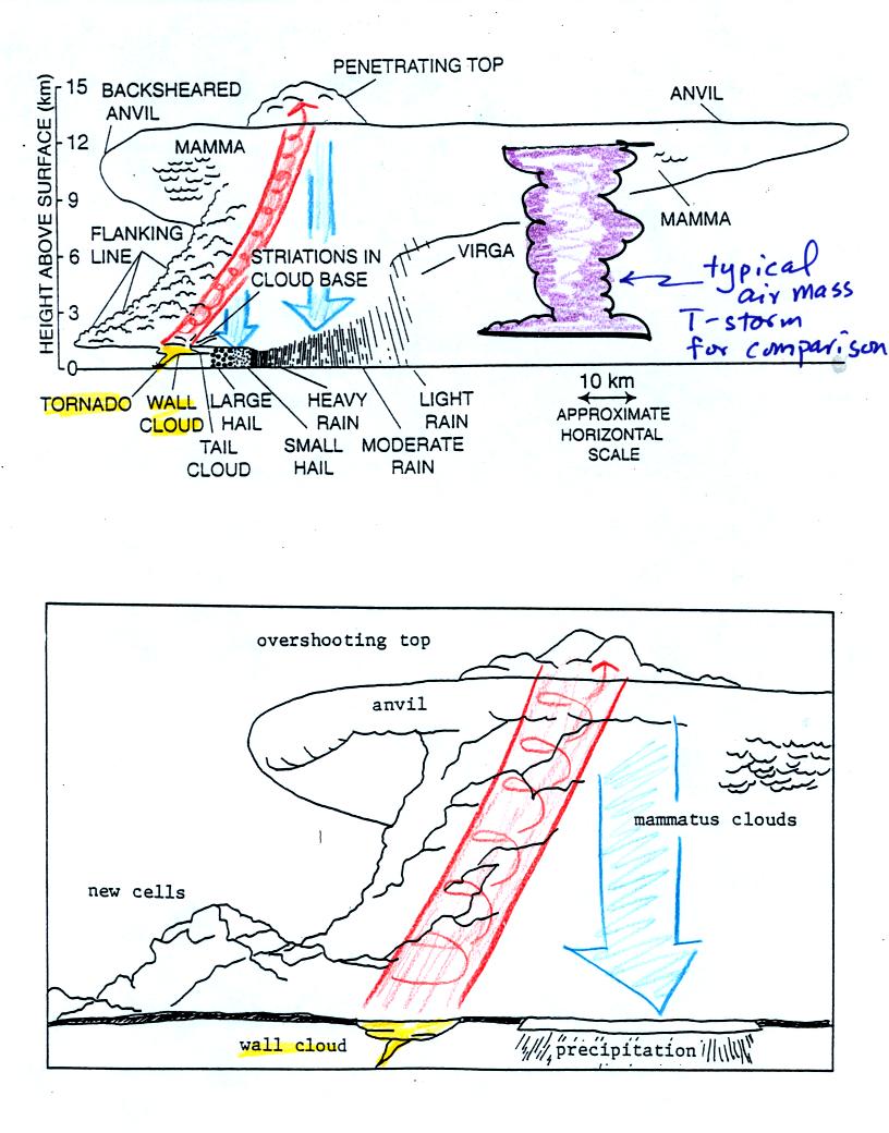
Sketches showing some of the characteristic features
of
supercell thunderstorms. Supercells are first of all much larger
than ordinary air mass
thunderstorms (a purple air mass T-storm is superimposed on the top
figure for comparison). In
an ordinary thunderstorm the updraft is unable to penetrate into the
very
stable air in the stratosphere. The upward moving air just
flattens out and forms an anvil. In a supercell the
rotating updraft (shown in orange above) is strong enough to penetrate
into the stratosphere. This
produces the overshooting top or dome feature above. A wall cloud
and a tornado are shown at the bottom of the mesocyclone. The
flanking line is a line of new cells trying to form alongside the
supercell thunderstorm.
A photograph of a distant supercell thunderstorm was shown
in the next
video tape. A computer simulation of the air motions inside a
supercell thunderstorm was also shown. Researchers understand the
development of a supercell pretty well. The exact process that
initiates tornado development is still unknown, however.

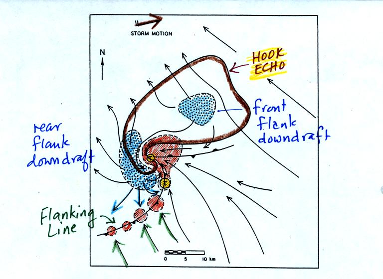
A radar picture of a supercell thunderstorm will often
have
a characteristic hook shape (outlined in brown above). The hook
is caused by spinning
motions inside the thunderstorm The large orange
shaded area is the
thunderstorm updraft, the mesoscylone. Smaller regions of rising
air are shown along a gust front.
Blue shaded areas show
where precipitation falls out of the cloud. The
flanking line of new cells is forming along the gust front produced
when
cold downdraft air from the thunderstorm (purple arrows) collides with
prexisting
winds (green arrows). Weak tornadoes can sometimes form along the
gust
front. The largest and strongest tornadoes come from the
mesocylone and wall cloud. The two tornado formation regions are
shaded yellow in the figure.

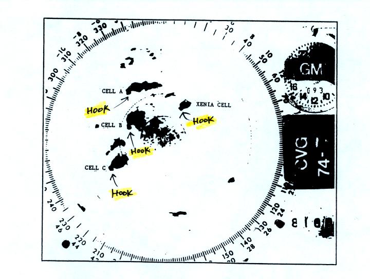
Actual radar display with 4 thunderstorms with
hook echoes. The hook echo feature is not always easy to
spot. The "Xenia cell" produced a large tornado.
The last video featured a tornado observed in Pampa, Texas and was
shown at this point. At one point the tornado winds just above
the ground were estimated at 250 MPH. Several vehicles (pickups
and a van) were seen on the video being thrown from the tornado cloud
at a height of about 100 feet at speeds of 80 to 90 MPH. Imagine
something like that coming down in your backyard.
The
Fujita Scale is used to rate
tornado strength or severity. We spent the next
part of the class looking at photographs of tornado damage.
Simplified,
Easy-to-Remember version of the Fujita Scale
winds < 100 MPH
F0
|
|
F1
|
roof
damage,
mobile home tipped over
|
microburst winds can cause this degree of damage
winds 100 to 200 MPH
F2
|
roof
gone,
outside walls still standing
|
F3
|
outside
walls gone,
inside walls intact
|
winds 200 to 300 MPH
F4
|
home
destroyed,
debris nearby
|
F5
|
home
destroyed,
debris carried away
|
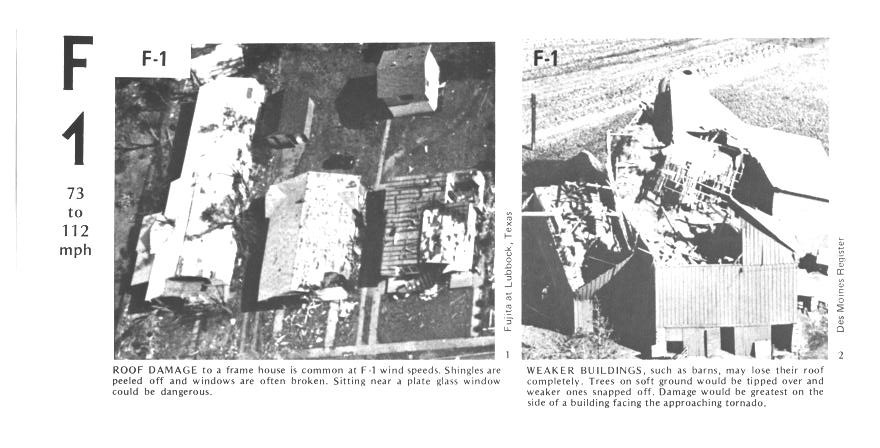
Here are some photographs of tornado damage

The buildings on the left suffered light roof
damage.
The barn
roof at right was more heavily damaged.

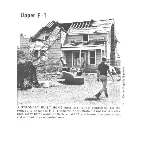
More severe damage to what appears to be a well built
house
roof.

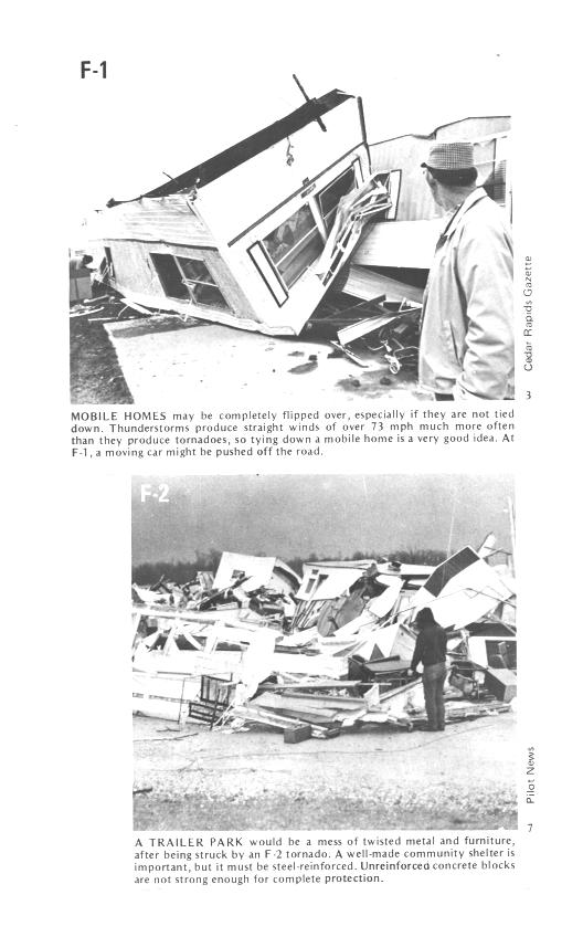
F1 tornado winds can tip over a mobile home if it is
not
tied down (the
caption states that an F1 tornado could blow a moving car off a
highway). F2 level winds (bottom photo) can roll and destroy the
mobile home.

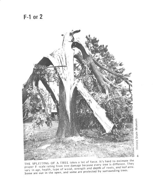
Trees, if not uprooted, can suffer serious damage from
F1 or
F2 tornado
winds.

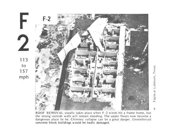
F2 level winds have completely removed the roof from
this
building. The building walls are still standing.

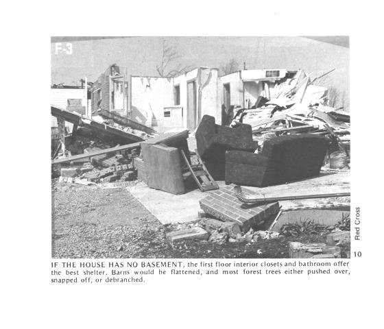
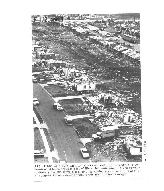
The roof is gone and the outer walls of this house were
knocked
down. This is characteristic of F3 level damage. In a house
without a basement or storm cellar it would be best to seek shelter in
an interior closet or bathroom.

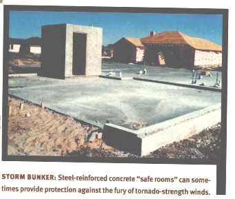
In some tornado prone areas, people construct a small closet
or room
inside their home made of reinforced concrete. A better solution
might be to have a storm cellar located underground.

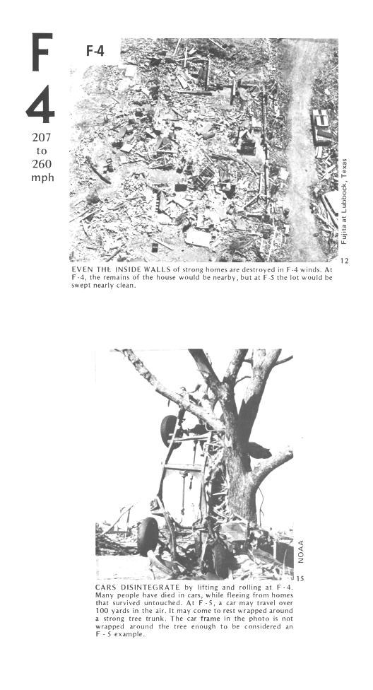
All of the walls were knocked down in the top photo but
the
debris is
left nearby. This is characteristic of F4 level damage. All
of the sheet metal in the car body has been removed in the bottom photo
and the car chasis has been bent around a tree. Note the tree has
been stripped of all but the largest branches.

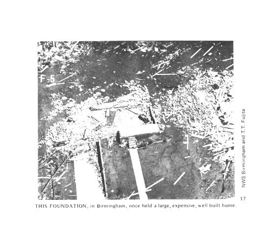
An F5 tornado completely destroyed the home in the
photo
above and
removed most of the debris. Only bricks and a few pieces of
lumber are left.

Several levels of damage are visible in the photograph
above. It
was
puzzling initially how some homes could be nearly destroyed while a
home nearby or in between was left with only light damage. One
possible explanation is shown below

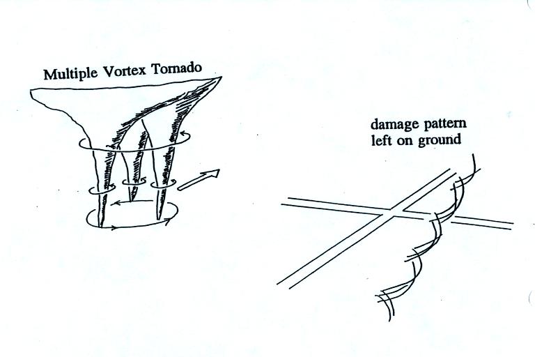
Some big strong tornadoes may
have
smaller more intense "suction
vortices" that spin around the center of the tornado. Tornado
researchers have actually seen the scouring pattern shown at right in
the figure above that the multiple vortices can leave behind.

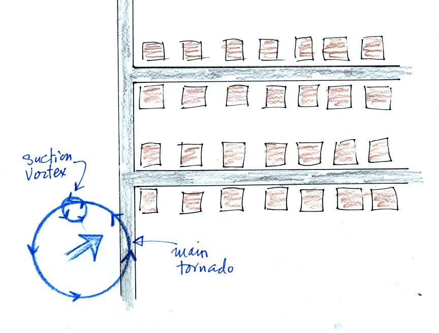
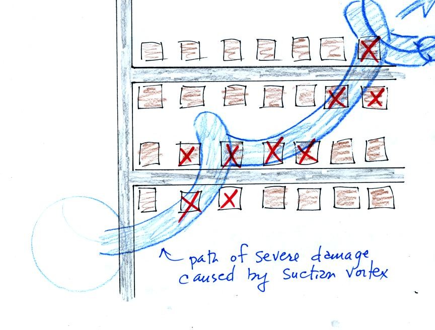
The
sketch above shows a tornado located SW of a neighborhood.
As the
tornado sweeps through the neighborhood, the suction vortex will
rotate around the core of the tornado.

The
homes marked in red would be damaged severely. The others
would receive less damage (remember, however that there would probably
be multiple suction vortices in the tornado).
At this point we watched the last of the tornado video tapes. It
showed a tornado that occurred in Pampa, Texas. Near the end of
the segment, video photography showed several vehicles (pick up trucks
and a van) that were being thrown around at 80 or 90 MPH by the tornado
winds. Winds speeds of about 250 MPH were estimated from the
video photography.
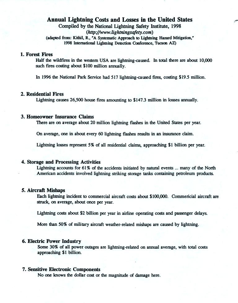
At this
point we moved into the section on lightning, the next topic in
class. Lightning kills around 100 people every year in the United
States. The next page (now about 10 years out of date) lists some
of the economic costs of lightning.

Lightning is the cost of about 30% of all power outages (yesterday's
power failure was a reminder of how inconvenient that can be). In
the western United States, lightning starts about half of all forest
fires. Lightning caused fires are a particular problem at the
beginning of the thunderstorm season in Arizona. At this time the
air underneath thunderstorms is still relatively dry. Rain
falling from a thunderstorm will often evaporate before reaching the
ground. Lightning then strikes dry ground, starts a fire, and
there isn't any rain to put out or at least slow the spread of the
fire. This is so called dry lightning.
Lighning is most commonly produced by thunderstorms (it has also
be observed in dust storms and volcanic eruptions).

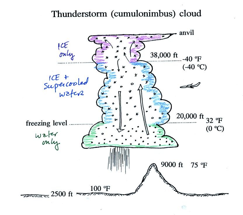
A typical summer thunderstorm in Tucson (found on p. 165 in the
photocopied Classnotes). Remember that
even in the summer
a large part of the middle of the middle of the cloud is found at below
freezing temperatures and contains a mixture of super cooled water
droplets and ice crystals. This is where the ice crystal process
of precipitation formation operatures and is also where electrical
charge is created. Doesn't that seem a little unusual that
electricity can come from such a cold and wet environment?
Here's a story (written during the Spring 2006 semester when the
course instructor thought he might be on the verge of a nervous
breakdown - something he is a little worried about this year) about how
a seemingly unrelated series of minor events could lead to a
potentially deadly result.
Jack
and the Lightning
Strike

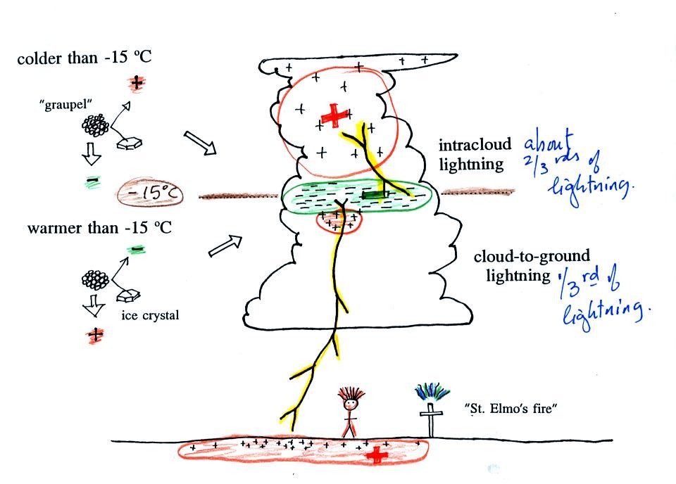
Collisions between precipitation particles produces the
electrical charge needed
for lightning.
When temperatures are below -15 C, graupel becomes negatively charged
after colliding with a snow crystal. The snow crystal is
positively charged and is carried up toward the top of the cloud by the
updraft winds. At temperature warmer than -15 (but still below
freezing), the charging is reversed. Large positive and negative
charge centers begin to build up inside the cloud. When the
electrical attrative forces between these charge centers gets
high enough lightning occurs.
Most
lightning (2/3) stays inside the cloud and travels between the main
positive
charge center near the top of the cloud and a large layer of negative
charge in the middle of the cloud; this is intracloud lightning.
About 1/3 of all lightning
flashes strike the ground. These are called cloud-to-ground
discharges.
A couple of interesting things that can happen at the ground when the
electrical forces get high enough. Attraction between positive
charge in the ground and the layer of negative charge in the cloud can
become strong enough that a person's hair will literally stand on end
(a dangerous situation to be in). St. Elmo's fire is a faint
electrical discharge that sometimes develops at the tops of elevated
objects during thundestorms.

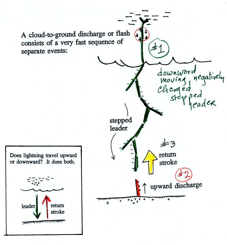
Most cloud to ground discharges begin with a negatively
charged
downward moving stepped leader. It makes its way down toward the
cloud in 50 m jumps that occur every 50 millionths of a second or
so. Every jump produces a short flash of light. An upward
discharge is initiated when the stepped leader nears the ground.
A powerful return stroke travels back up the channel (and out into all
the branches) once the upward discharge and the stepped leader
meet. These three steps are shown in additional detail below.

A sequence of stepped leader steps. Note each of the
channels in the drawing should actualy be superimposed on each
other. There is just a single channel that every 50 microseconds
of so gets 50 meters longer.

Several
positively charged upward discharges begin to travel upward from the
ground. One
of these will eventually intercept the stepped leader.
This
is what determines what will be struck by the lightning.
Lightning doesn't really know what it will strike until it gets close
to the ground. Lightning rods take advantage of this principle.

Houses with and without lightning rods are
shown
above. When lightning strikes the house without a lightning rod
the powerful return stroke travels into the house destroying the TV and
possibly starting the house on fire.
A lightning rod is supposed to intercept the stepped leader and safely
carry the lightning current around the house and into the ground.

The
connection between the stepped leader and the upward discharge creates
a "short circuit" between the charge in the cloud and the charge in the
ground. A powerful current travels back up the channel from the
ground toward the cloud. This is the return stroke. Large
currents (typically 30,000 amps in the first return stroke) heat the
air to around 30,000K (5 times hotter than the
surface of the sun) which causes the air to explode. When you
hear thunder, you are hearing the sound produced by this explosion.
Stepped leader - upward connecting discharge - return
stroke
animation
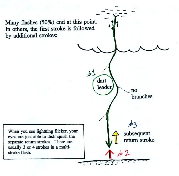
Many cloud-to-ground flashes end at this point. In
about 50% of cloud to ground discharges,
the stepped leader-upward
discharge-return stroke sequence repeats itself with a few subtle
differences.

A downward dart leader travels from the cloud to the
ground. The dart leader doesn't step but travels smoothly and follows
the channel created by the stepped leader (avoiding the
branches). It is followed by a slightly less powerful subsequent
return stroke that travels back up the channel to the cloud.

A normal still photograph would capture the
separate
return strokes
superimposed on each other. If you bumped or moved the camera
during the photograph the separate return strokes would be spread out
on the image.
The image above shows a multiple stroke flash consisting of 4 separate
return strokes.
There is enough time between separate return strokes (around 1/10 th
second) that your eye can
separate the individual flashes of light.
When lightning appears
to flicker you are seeing the separate return strokes in a multiple
stroke flash. The whole flash usually lasts 0.5 to 1 second.
Here are
some unusual types of lightning.

We had time at the end of class to talk about positive
lightning. Occasionally a lightning stroke will travel from the
positive charge
region in the top of the thunderstorm cloud to ground. These
types of strikes are more common at the ends of storms and in winter
storms. This is probably because the top part of the cloud gets
pushed sideways away from the middle and bottom portions of the
cloud. Positive strokes are very powerful. They sometimes
produce an unusually loud and long lasting clap of thunder.

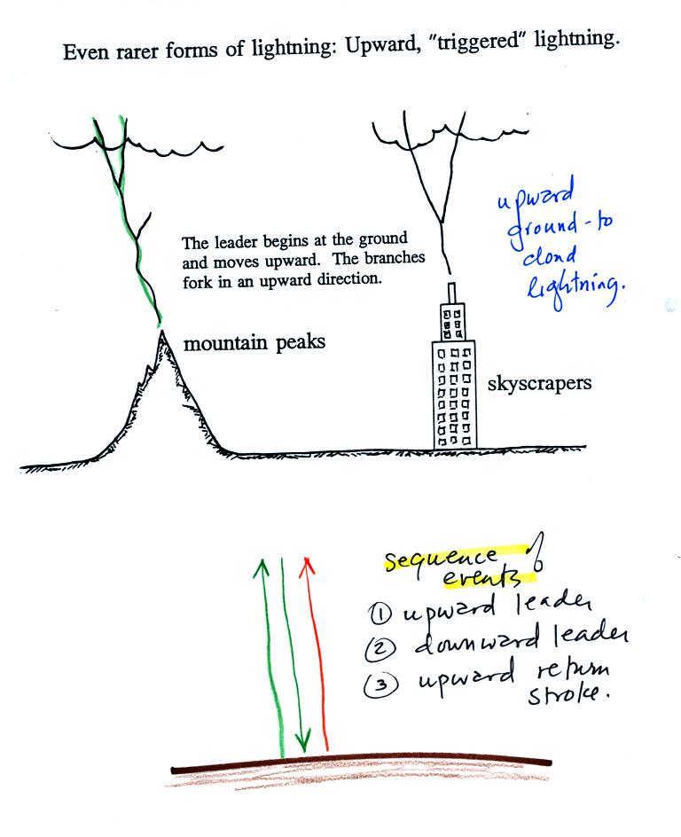
Lightning sometimes starts at the ground and travels
upward.
Upward lightning is generally only initiated by mountains and tall
objects such as a skyscraper or a tower of some kind. These
discharges are initiated by an upward leader. This is followed by
a more normal downward leader and an upward return stroke.

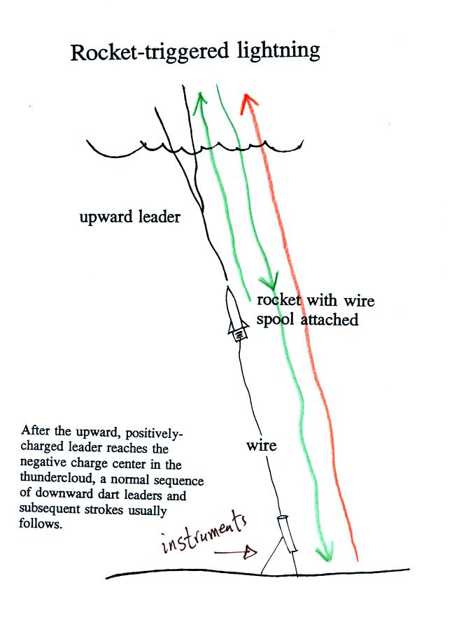
Scientists are able to trigger lightning by firing a small
rocket up
toward a thunderstorm. The rocket is connected by a thin wire to
the ground. When the rocket gets 50 to 100 m above the ground
upward lightning will develop off of the top of the wire.
Scientists are able to take closeup photographs and make measurements
of lightning currents using triggered lightning. Triggered
lightning can also be used to test the operation of lightning
protection devices. A short video showing rocket triggered
lightning experiments will be shown in class next Tuesday.
