Tuesday Feb. 17, 2009
A new homework assignment was handed out in class today. You can
download it here.
We will be covering the topic of cloud electrification this week.
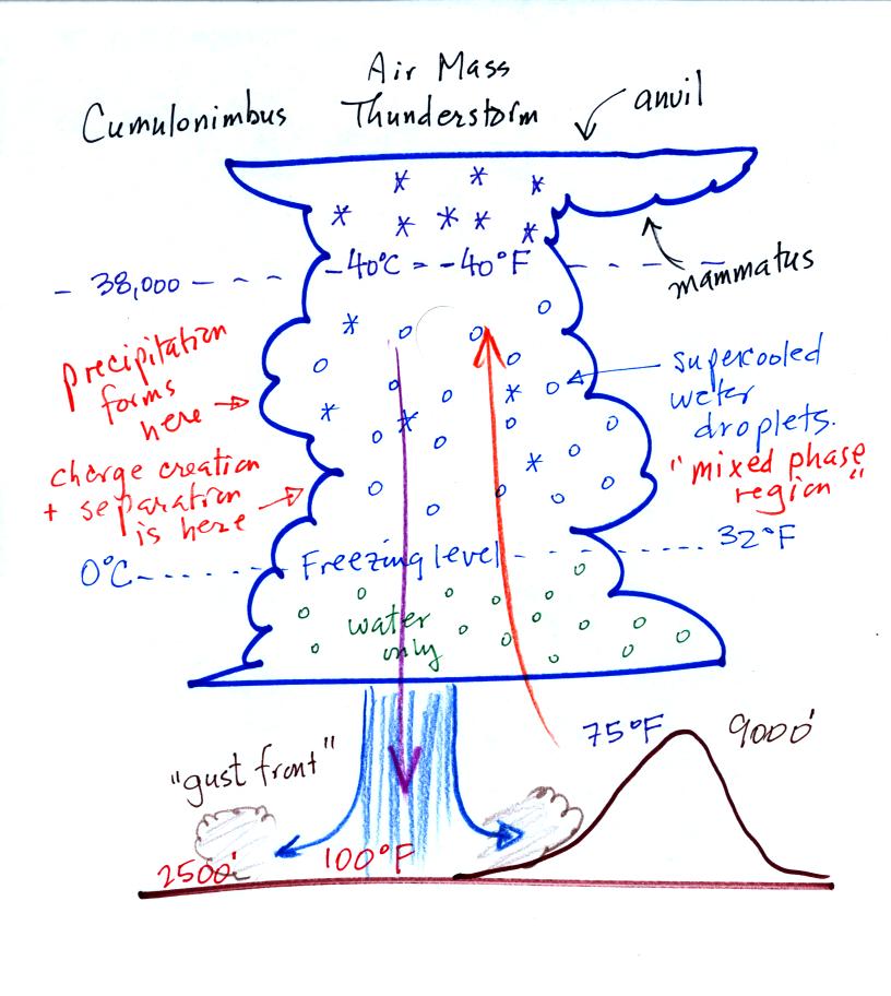
First we need to do a little review. We will start with the
microphysical structure of a cold thunderstorm cloud. Cold refers
to the fact that much of the cloud is found at high enough altitude
that it is at below freezing
temperatures and contains ice crystals. This is the case for
thunderstorm clouds even in
Tucson on the hottest day of the summer.
The important part of the cloud, both for precipitation
formation and electrification , is the middle mixed phase region.
There you find ice crystals and lots of supercooled water droplets
(water cooled to below freezing that is unable to freeze).
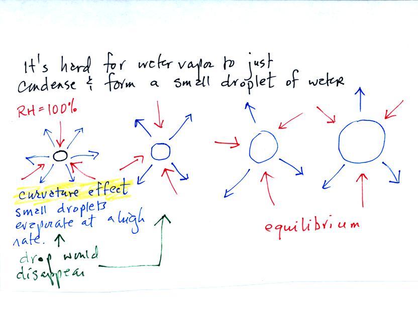
The formation of water droplets does not occur as you might have
imagined. You might have thought that once the RH reaches 100%
that water vapor would simply condense and form little droplets.
But actually it is hard to form small droplets. This is
because small droplets evaporate at a high rate due to the curvature
effect (the blue arrows above represent evaporation, the red arrows
condensation)
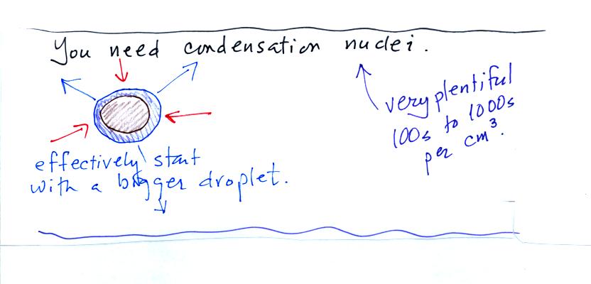
It is much easier for droplets to form when water vapor condenses
onto small particles in the air called condensation nuclei. The
droplets start large enough that the curvature of the water surface
doesn't affect the rate of evaporation. Condensation nuclei are
plentiful even in clean air, where they are typically found in
concentrations of 100s per cubic centimeter.
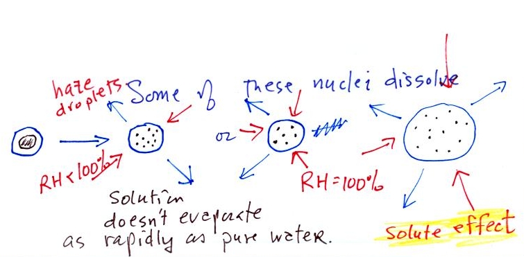
Condensation nuclei can play an additional role when they dissolve
in water.
The resulting solution has a lower rate of evaporation than a
droplet composed of pure water. Droplets can begin to form before
the relative humidity reaches 100%.
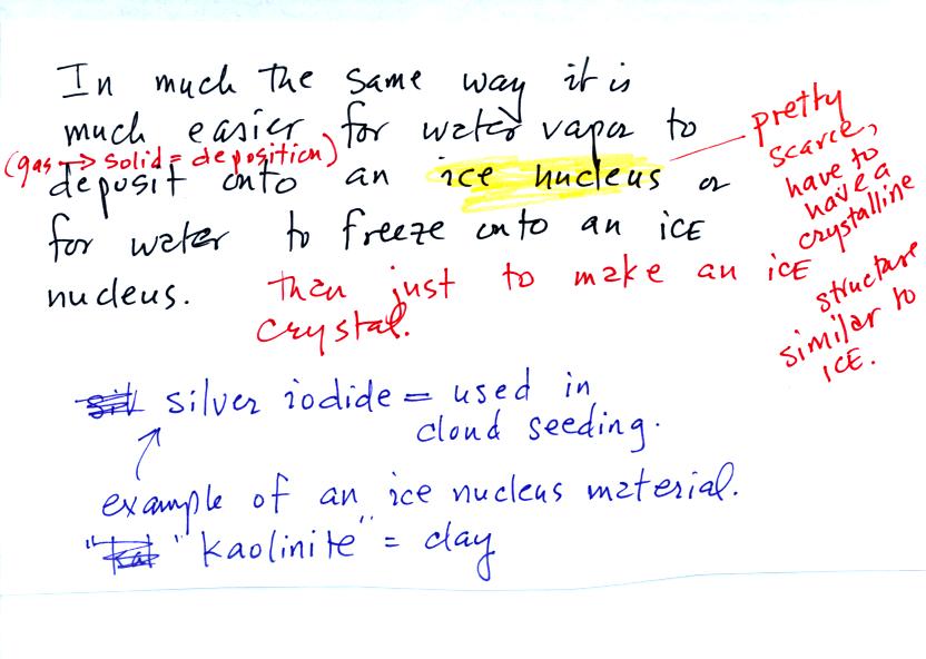
Ice crystal nuclei also make it easier for ice crystals to form by
deposition (deposition is a gas to solid phase change) or by freezing
of water droplets. Ice crystal nuclei are however relatively
scarce. This is because the nucleus must be composed of a
material with a crystalline structure that resembles ice. Silver
iodide works well as an ice nucleus, so does kaolinite (a type of clay
or mineral), I believe.
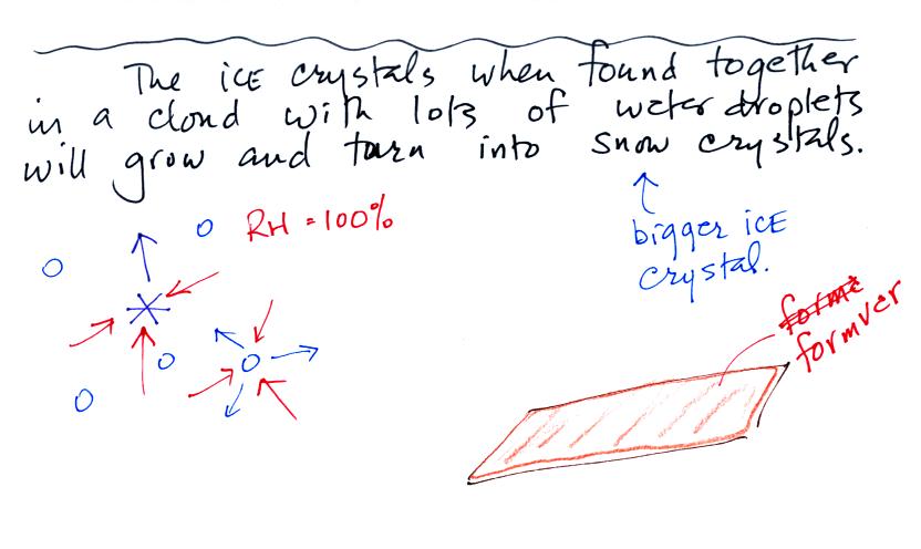
Ice crystals evaporate (actually they sublimate) at a slower rate
than water droplets. Because the surrounding air is moist enough
to keep the water droplets in equilibrium (3 arrows of condensation
balancing 3 arrows of evaporation in the figure above), and because
water vapor will condense onto the ice crystals at the same rate, the
ice crystals will grow and become snow crystals. Have a look at
photomicrographs of some snow crystals at www.snowcrystals.com.
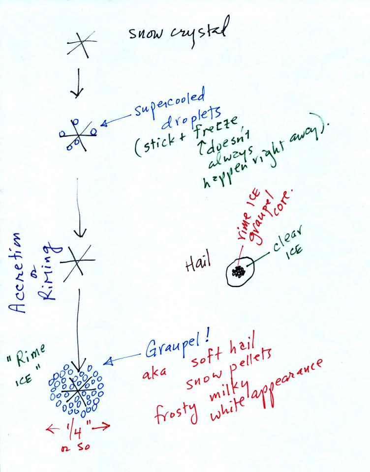
In this figure, a falling snow crystal is colliding with
supercooled water droplets. They stick to the crystal and
freeze. This process is called accretion or riming. If this
goes on long enough the original snow crystal can get completely
covered with frozen water droplets. The resulting precipitation
particle is called graupel. It is often mistaken for hail.
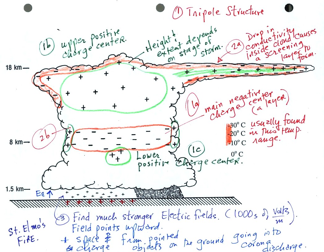
This figure shows the common distribution of electrical charge in
a mature thunderstorm. The structure is tripolar and consists of
an upper positive charge center (1b), a lower layer of negative charge
(1a), and smaller lower positive charge centers (1c). Screening
layers form around the edges of the cloud (2a &
2b). Strong electrical fields may cause pointed
objects on the ground to go into corona discharge and fill the air
above the ground with positive space charge (3).
The layer of negative charge in thunderstorms seems to always be found
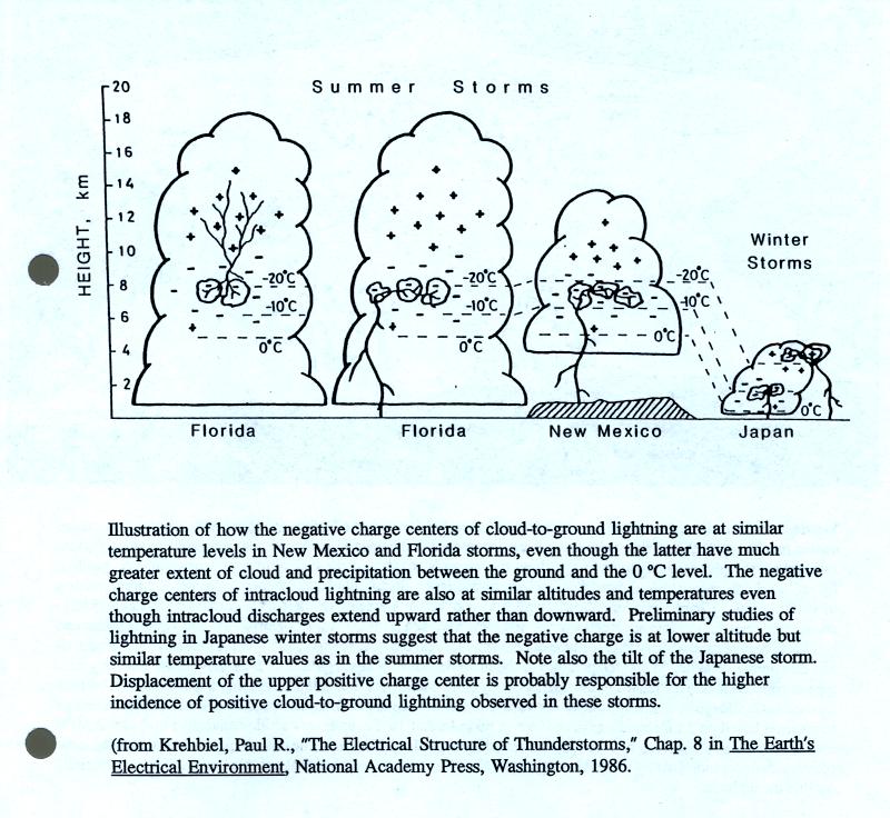
in the -10 to -30 C temperature range.
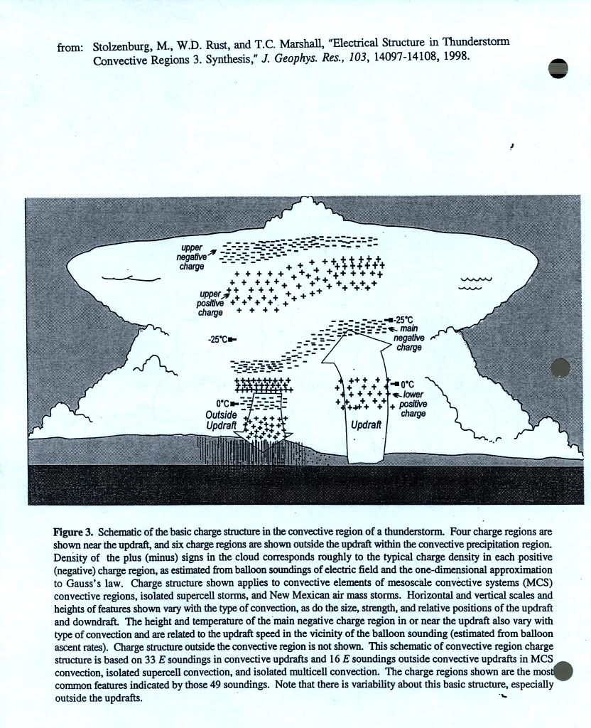
The distribution of charge in thunderstorms is often much more complex
than the simple tripolar model discussed above.
We had
just enough time at the end of the class to look at one of the
processes that may cause clouds to become electrified.
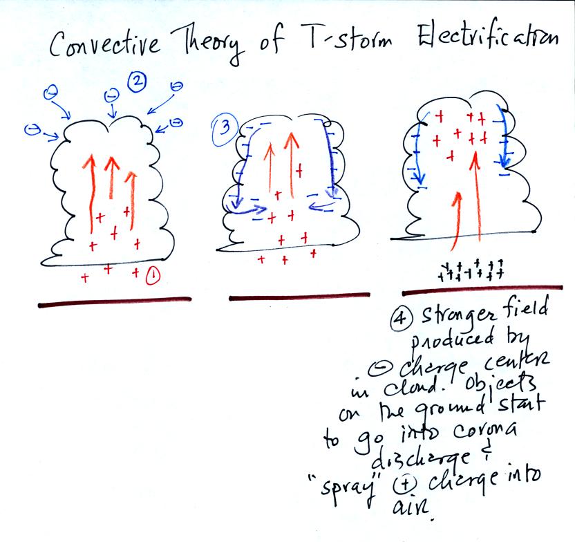
In the convective theory, positive space charge between the cloud
base and the ground is carried upward into the cloud by the
updraft. Negative charge carriers in the surrounding air are
drawn to the positive charge in the top of the cloud and form a
screening layer. Cloud edge motions carry this negative charge
down and into the middle center of the cloud to form the main negative
charge center. The electric field at the ground intensifies
because of the close proximity of negative charge in the cloud.
Objects on the ground go into corona discharge and "spray" positive
charge into the air. The convective theory is generally not
considered to be a viable mechanism for the initial electrification of
thunderstorms.