The ice crystal process
is a
whole lot more interesting because of the variety of different types of
precipitation that it can produce. Much of what is shown above
happens inside the cloud, some of it happens after the particles leave
the cloud and fall toward the ground.
Before
learning about the ice
crystal process, we need to first look at the structure of cold
clouds.
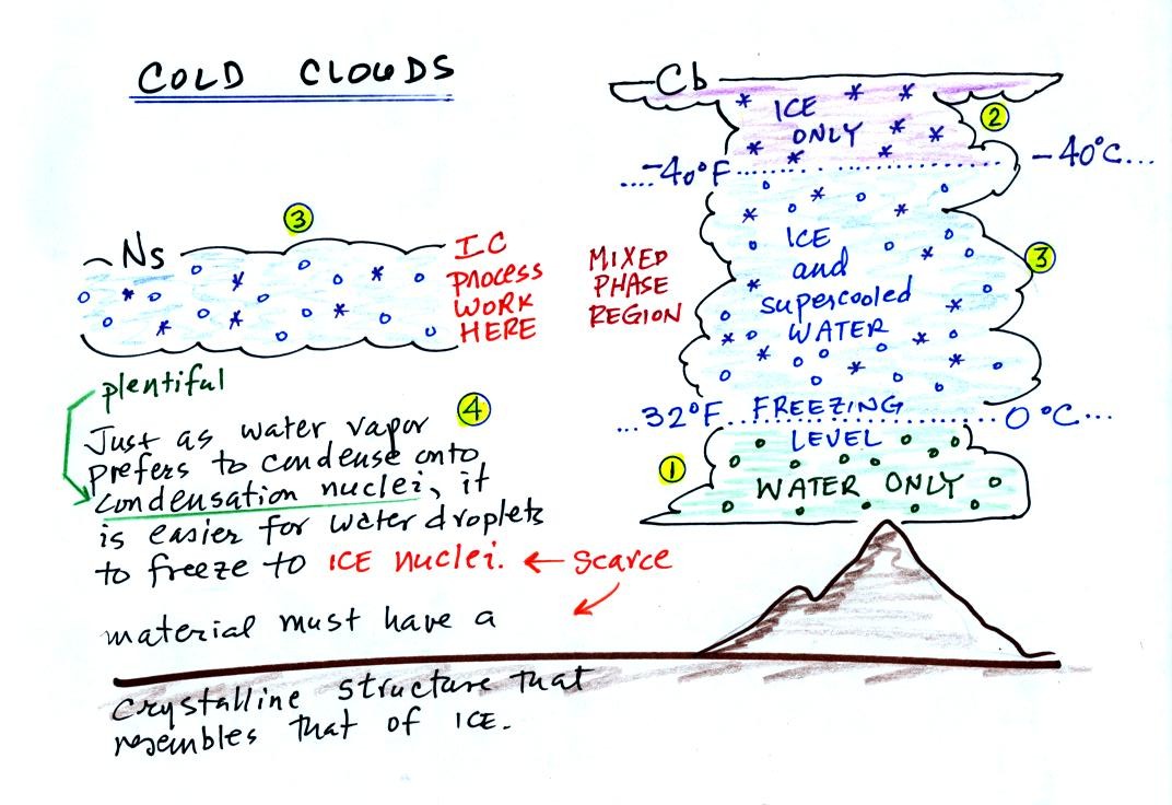
The figure below is a redrawn version of what was shown in class.
The bottom of the thunderstorm, Point 1, is warm
enough
(warmer than freezing) to just
contain water
droplets. The top of the thunderstorm, Point 2, is colder than
-40 C (also -40 F) and just contains ice crystals. The
interesting part of the
thunderstorm and the
nimbostratus cloud is the middle part, Point 3, that contains both
supercooled water
droplets (water that has
been cooled to below freezing but hasn't frozen) and ice
crystals.
This is called the mixed phase
region. This is where the ice crystal process will be able
to produce
precipitation. This is also where the electrical charge that
results in lightning is generated.
The supercooled water droplets aren't able to freeze even though
they
have been cooled below freezing. At Point 4 we see this is
because it is much
easier for small droplets of water to freeze onto an ice crystal
nucleus or for water vapor to be deposited onto an ice crystal nucleus
(just like it is easier for water vapor to condense onto
condensation nuclei rather than condensing and forming a small droplet
of pure water). Not just any material will work as an ice nucleus
however. The material must have
a crystalline structure that is like that of ice. There just
aren't very many materials with this property and as a result ice
crystal nuclei are rather scarce.
We'll see
next how the ice crystal process works. There are a couple of
"tricky" parts.
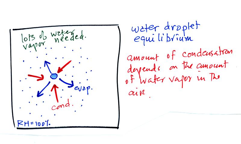
The first figure above (see p.101 in the photocopied
Class
Notes)
shows a water droplet in equilibrium with its surroundings..The droplet
is evaporating (the 3 blue arrows in the figure). The rate of
evaporation will depend on the temperature of the water droplet.
The droplet is surrounded by air that is saturated with water vapor
(the droplet is inside a cloud where the relative humidity is
100%). This means there is enough water vapor to be able to
supply 3 arrows of condensation. Because the droplet loses and
gains water vapor at equal rates it doesn't grow or shrink.
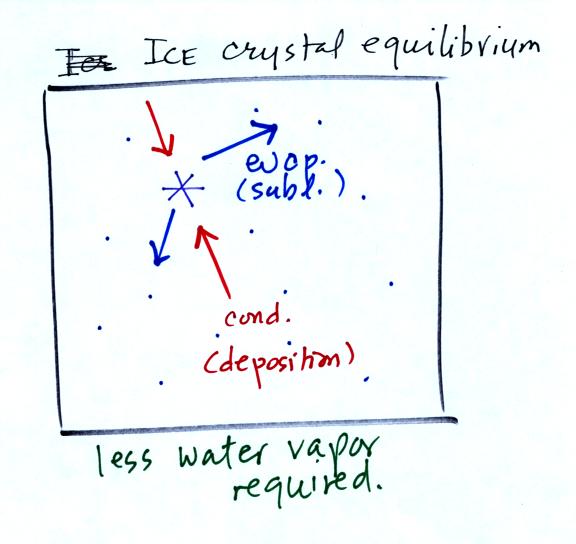
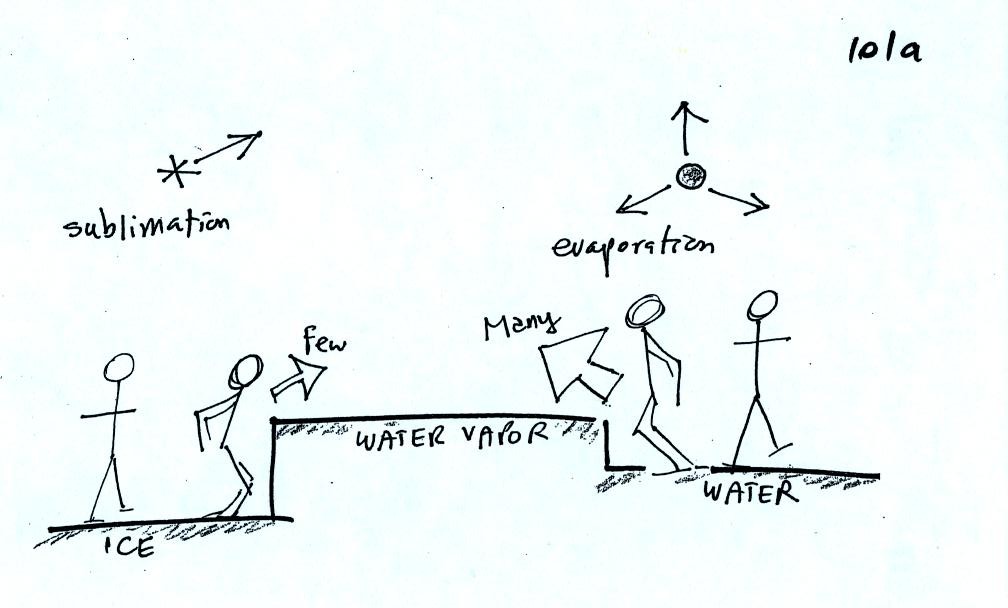
This figure shows what is required
for an ice crystal (at
the same
temperature) to be in equilibrium with its surroundings. First,
the ice crystal won't evaporate as rapidly as the water droplet (only
two arrows are shown). Going from ice to water vapor is a bigger
jump than going from water to water vapor. There won't be as many
ice molecules with enough energy to make that jump. A sort of
analogous situation is shown in the figure below. The class
instructor could with a little warmup and practice jump from the floor
up and onto the seat of a chair (maybe 15 inches tall). Trust me,
he could, and so could most of the people in the room. The class
instructor does some stupid things in class, but he wouldn't begin to
consider trying to jump from the floor up to the top of the cabinet (30
inches or more).
To be in equilibrium only two arrows of condensation are
needed.
There doesn't need to be as much water vapor in the air surrounding the
ice crystal to supply this lower rate of condensation.
There are going to be fewer people able to make the
big jump on
the
left just as there are fewer ice molecules able to sublimate.
Going from water to water vapor is a "smaller jump" and more molecules
are able to do just as more people would be able to make the shorter
jump at right in the picture above.
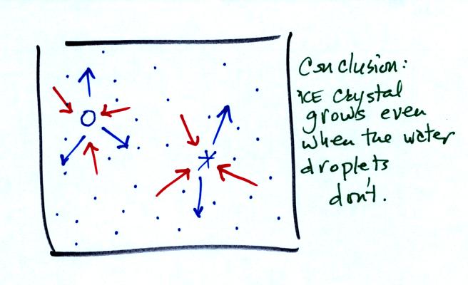
Now what happens in the mixed phase region of a cold cloud
is that
ice crystals find themselves in the very moist surroundings needed for
water droplet equilibrium. This is shown below.
The water droplet is in equilibrium (3 arrows of evaporation
and 3
arrows of condensation) with the surroundings. The ice crystal is
evaporating more slowly than the water droplet. Because the ice
crystal is in the same surroundings as the water droplet water vapor
will be condensing onto the ice crystal at the same rate as onto the
water droplet. The ice
crystal isn't in equilibrium, condensation
(3 arrows) exceeds evaporation (2 arrows) and the ice crystal will
grow. That's
what makes the ice crystal process work.
The equal rates of condensation are shown in the figure
below using the
earlier analogy.
Even though he was afraid to try to jump up to the top
of
the counter, the instructor could jump from the counter to the floor.
Now
we will see what can happen once the ice crystal has had a chance to
grow a little bit.
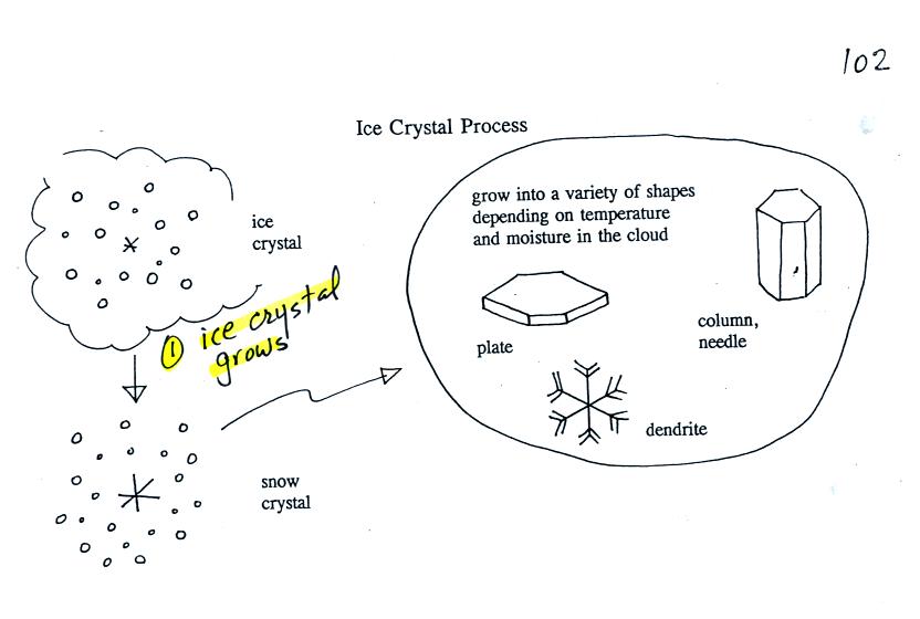
Once an ice
crystal has grown a
little bit it becomes a snow crystal (this figure is on p. 102 in the
photocopied classnotes). Snow crystals can have a variety of
shapes
(plates, dendrites, columns, needles, etc.; these are called crystal
habits) depending on the conditions (temperature and
moisture)
in the cloud. Dendrites are the most common because they form
where there
is the most moisture available for growth. With more raw material
available it makes sense there would be more of this particular snow
crystal
shape.
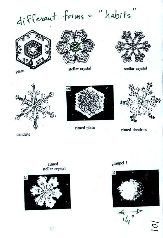
Here are some actual photographs of snow crystals (taken with a
microscope). Snow crystals are usually 100 or a few 100s of
micrometers
in diameter (tenths of a millimeter in diameter).
You'll find some much better photographs and a pile of addtional
information
about snow crystals at www.snowcrystals.com
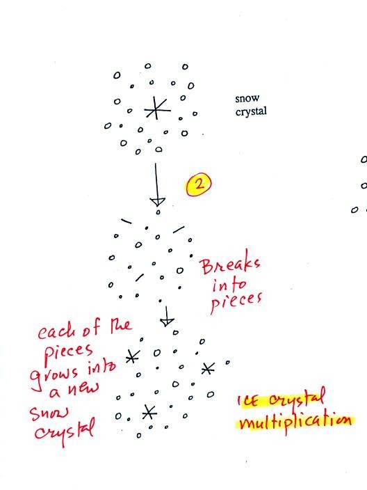
A
variety of things can happen once a snow crystal forms. First it
can
break into pieces, then each of the pieces can grow into a new snow
crystal. Because snow crystals are otherwise in rather short
supply, ice
crystal multiplication is a way of increasing the amount of
precipitation that
ultimately falls from the cloud.
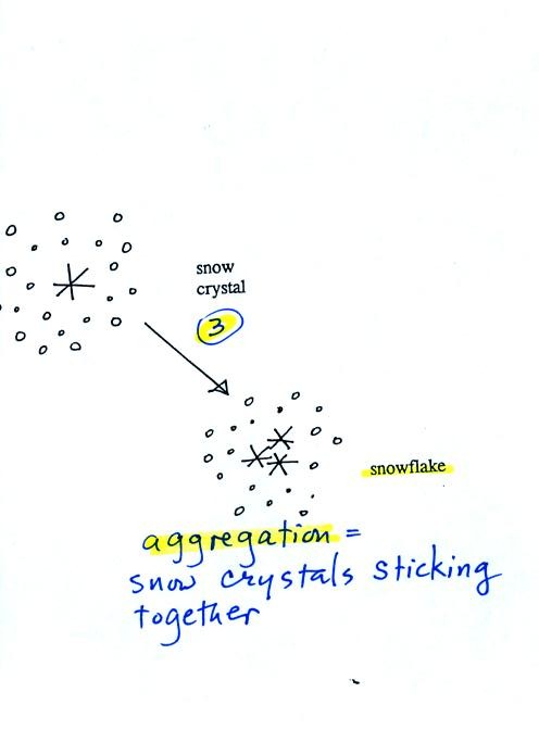
Several snow
crystals can collide
and stick together to form a snowflake. Snow crystals are small,
a few
tenths of a millimeter across. Snowflakes can be much larger and
are made
up of many snow crystals stuck together. The sticking together or
clumping together of snow crystals is called aggregation.
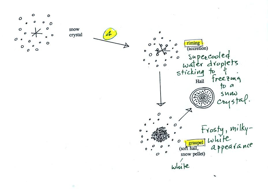
Snow crystals can
collide with supercooled water droplets. The
water
droplets may stick and freeze to the snow crystal. This process
is called
riming or accretion (note it is really the same idea as collision and
coalescence). If a snow crystal collides with enough water
droplets it
can be completely covered with ice. The resulting particle is
called
graupel (or snow pellets). Graupel is sometimes mistaken for hail
and is
called soft hail or snow pellets. Rime ice has a frosty milky
white
appearance. A graupel particle resembles a miniature snow
ball.
Graupel particles often serve as the nucleus for a hailstone.
This figure gives you an idea of how hail forms.

In the figure
above a hailstone
starts with a graupel particle (Pt. 1, colored green to represent rime
ice). The
graupel falls or gets carried into a part of the cloud where it
collides with a
large number of supercooled water droplets which stick to the graupel
but don't
immediately freeze. The graupel gets coated with a layer of water
(blue) at Pt. 2. The particle then moves into a colder part of
the cloud
and the
water layer freeze producing a layer of clear ice (the clear ice,
colored
violet, has a distinctly different appearance from the milky white rime
ice), Pt. 3. In Tucson this is often the only example of hail that you
will see:
a graupel particle core with a single layer of clear ice.
In the severe thunderstorms in the Central Plains, the hailstone can
pick up a
new layer of rime ice, followed by another layer of water which
subsequently
freezes to produce a layer of clear ice.
This cycle can repeat several times; large hailstones can be composed
of many
alternating layers of rime and clear ice. An unusually
large
hailstone (around 3 inches in diameter) has been cut in half to show
(below)
the different layers of ice.

Hail is produced
in strong
thunderstorms with tilted updrafts. You would never see hail
falling from a nimbostratus cloud. The figure below wasn't shown
in
class.

The growing
hailstone can fall
back into the updraft (rather than falling out of the cloud) and be
carried
back up toward the top of the cloud. In this way the hailstone
can
complete several cycles through the interior of the cloud.
Students in
class today were given the option of answering the questions below and
turning in their answers at the end of class for a little bit of extra
credit.
Here are the
questions and the answers:
1. Dendrites, plates, and columns are all names of
different types of snow crystals.
2. Several snow crystals sticking together
would form
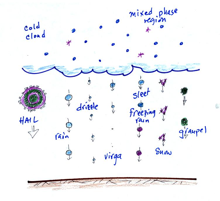
a. hail
b. graupel
c. sleet
d. snow
3. The largest raindrops are only about 5 or 6 mm (~ 1/4
inch) in diameter. What frozen precipitation particle can get
much larger
than this? Hail.
4. How many 20 micrometer diameter cloud droplets would be
needed to make one 200 micrometer diameter drop of drizzle? The
200 micrometer drizzle droplet is 10 times bigger across than the 20
micrometer cloud droplet. Volume is length x width x height. So
there is a factor of 10 x 10 x 10 = 1000 times difference in
volume.
5. Is most of the rain in Tucson produced by the
COLLISION-COALESCENCE or the ICE
CRYSTAL process?
6. Which of the following is found in the greatest amounts
in the mixed-phase region of a
cold cloud?
a. ice crystal nuclei
b. ice crystals c. supercooled
water droplets d. graupel
7. What differences are there between condensation nuclei
and ice crystal nuclei? Ice
nuclei are much less abundant than condensation nuclei. Ice
nuclei must have a crystalline structure resembling ice. The same
requirement doesn't apply to condensation nuclei.
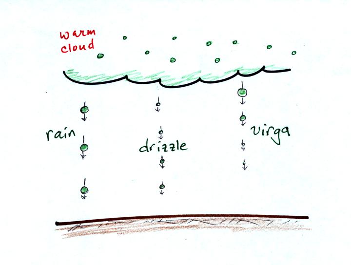
8. What is virga?
Rain or drizzle that evaporates
before reaching the ground.