Friday Mar. 27, 2009
click here to download today's notes in a more printer friendly format

Sorry about the music.  It worked fine in my office earlier in the day, but by class time the song I had wanted to play was gone and had been replaced by another song.  I might really push my luck and try again on Monday.

Midterm grade summaries were handed out in class today. 

The Experiment #2 revised reports and the humidity Optional Assignment were collected in class today.  The Expt. #3 reports are due next Monday.


You'd feel pretty cold on a dry 80 F day if you were to step out of a swimming pool.  The water on your body would evaporate and there wouldn't be much condensation from the moisture in the air to offset the cooling with warming.

On a humid 80 F day, you wouldn't feel nearly as cool.  You might not even feel cool.  The water on your body would still be evaporating but there would be almost an equal amount of condensation from water vapor in the air.  The condensation would act to warm you and could almost cancel out the evaporative cooling (the rates of evaporation and condensation would be equal if the RH were 100%)


Things are a little different on hot days. 
Our bodies try to keep themselves cool by perspiring during hot weather.  According to a textbook we used in a previous semester "... over ten million sweat glands wet the body with as much as two liters of liquid/hour." 

On a dry 110 F day you probably wouldn't feel cool, but the evaporation would probably be sufficient to prevent your body from overheating.  When the RH is high, there might not be enough net evaporation to cool your body.  You could end up with HEAT STROKE - a potentially deadly condition.  

Wind and cold temperatures make it feel colder than it really is,
High temperatures and high humidity make it feel hotter than it is.

The wind chill temperature measures the effect of cold temperatures and wind,
The heat index measures the combined effects of high temperatures and high relative humidities.


Point 1 shows that when moist air next to the ground is cooled to and below the dew point, water vapor condenses onto (or is deposited onto) the ground or objects on the ground.  This is dew, frozen dew, and frost.  We covered this in class on Wednesday.

Air above the ground can also be cooled to the dew point.  When that happens (Point 2 above) it is much easier for water vapor to condense onto something rather than just forming a small droplet of pure water.    In air above the ground water vapor condenses onto small particles in the air called condensation nuclei.  The small water droplets that form are themselves usually too small to be seen with the naked eye.  We can tell they are present (Point 3) because they either scatter (haze or fog) or reflect (clouds) sunlight. 

We'll learn a little bit about the formation of fog and haze today (Point 4) and will do a cloud-in-a-bottle demonstration (Point 5) to see the role that cloud condensation nuclei can play in cloud formation.


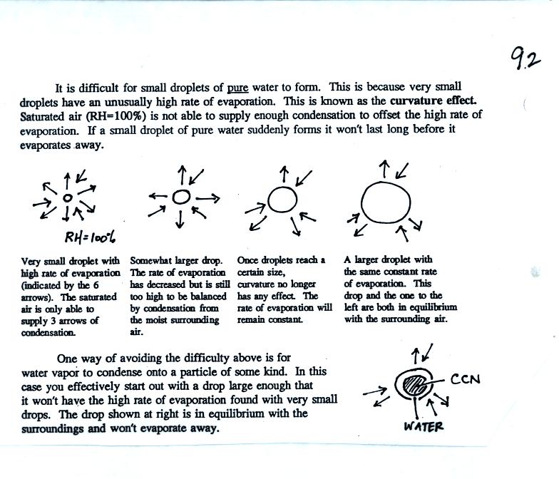
You can learn why it is so hard to form small droplets of pure water by reading the top of p. 92 in the photocopied class notes.


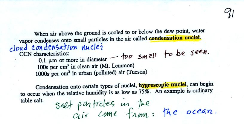
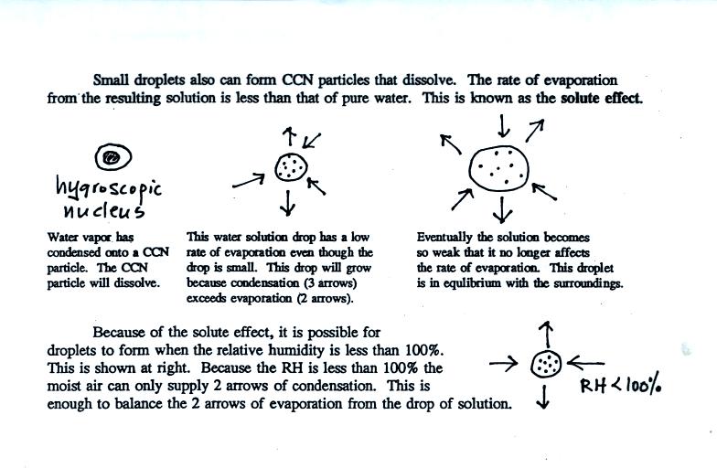
Water vapor will condense onto certain kinds of condensation nuclei even when the relative humidity is below 100% (again you will find some explanation of this on the bottom of p. 92).  These are called hygroscopic nuclei.

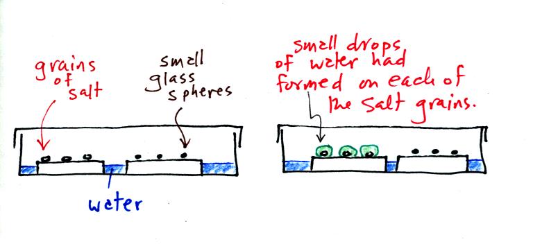
A short video showed how water vapor would, over time, preferentially condense onto small grains of salt rather than small spheres of glass.  The figure below wasn't shown in class.


The start of the video at left showed the small grains of salt were placed on a platform in a petri dish containing water.  Some small spheres of glass were placed in the same dish.  After about 1 hour small drops of water had formed around each of the grains of salt (shown above at right). 

In humid parts of the US, water will condense onto the grains of salt in a salt shaker causing them to stick together.  Grains of rice apparently absorb moisture which keeps this from happening and allows the salt to flow freely out of the shaker when needed.


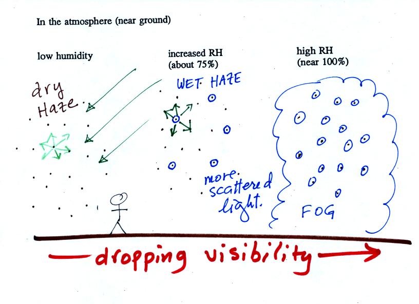
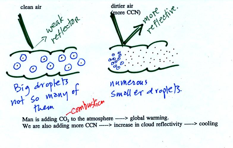
This figure (bottom of p. 91)  shows how cloud condensation nuclei and increasing relative humidity can affect the appearance of the sky and the visibility.

The air in the left most figure is relatively dry.  Even though the condensation nuclei particles are too small to be seen with the human eye you can tell they are there because they scatter sunlight.  When you look at the sky you see the deep blue color caused by scattering of sunlight by air molecules mixed together with some white light scattered by the condensation nuclei.  This changes the color of the sky from a deep blue to a bluish white color.  The more particles there are the whiter the sky becomes.  This is called "dry haze."

The middle picture shows what happens when you drive from the dry southwestern part of the US into the humid southeastern US.  One of the first things you would notice is the hazier appearance of the air and a decrease in visibility.  Because the relative humidity is high, water vapor begins to condense onto some of the condensation nuclei particles (the hygroscopic nuclei) in the air and forms small water droplets.  The water droplets scatter more sunlight than just small particles alone.  The increase in the amount of scattered light is what gives the air its hazier appearance. This is called "wet haze."

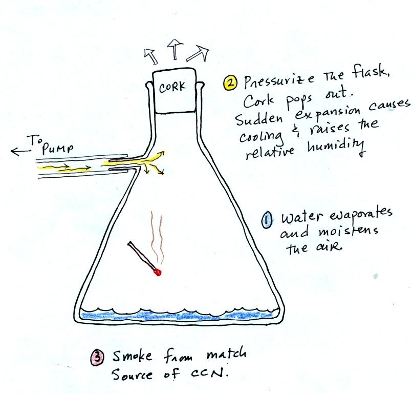
Finally when the relative humidity increases to 100% fog forms.  Fog can cause a severe drop in the visibility.  The thickest fog forms in dirty air that contains lots of condensation nuclei.  We will see this effect in the cloud-in-a-bottle demonstration coming up at the end of class.
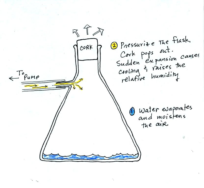
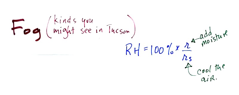

There are two types of fog that you might occasionally see in Tucson (fog is fairly infrequent because the air is so dry)
To produce fog you first need to increase the relative humidity (RH) to 100%


You can do this either by cooling the air or adding moisture to and saturating the air (both will increase the ratio in the RH formula above).

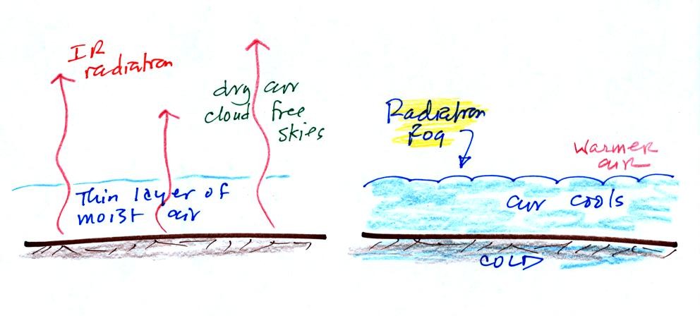
The ground cools during the night by emitting IR radiation (left figure below).  The ground cools most rapidly when the skies are free of clouds and the air is dry (except for a thin layer next to the ground).  These are the conditions that favor the formation of radiation fog.

Air in contact with the ground cools and radiation fog can form (right figure above).  Because the fog cloud is colder than the air right above, this is a stable situation.  The fog clouds "hugs" the ground.

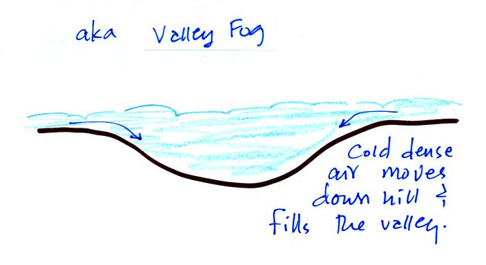
Radiation fog is sometimes called valley fog.


The cold dense air will move downhill and fill low lying areas with fog cloud.   It is often difficult for the sun to warm the air and dissipate thick clouds of valley fog.

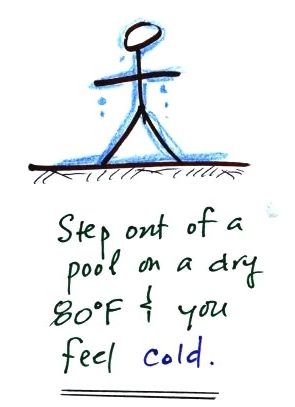
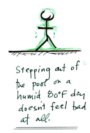
Steam fog (aka evaporation fog or mixing fog) is commonly observed on cold mornings over the relatively warm water in a swimming pool.


Water evaporating from the pool saturates the cold air above.  Because the fog cloud is warmer than the cold surrounding air, the fog clouds float upward.

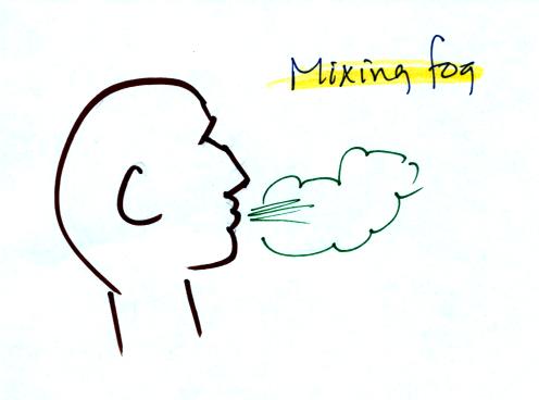
When you "see your breath" on a cold day (the figure below wasn't shown in class)


you're seeing mixing fog.  Warm moist air from your mouth mixes with the colder air outside.  The mixture is saturated and a fog cloud forms.


If there ever was a time for a demonstration it was class on Friday (honestly I've rarely seen the negative vibes reach the level they did last Friday). 
Cooling air and changing relative humidity, condensation nuclei, and scattering of light are all involved in this demonstration.


We used a strong thick-walled 4 liter flask (flasks like this are designed to not implode when all of the air is pumped out of them, they aren't designed to not explode when pressurized).  There was a little water in the bottom of the flask to moisten the air in the flask.  Next we pressurized the air in the flask.  At some point the pressure blows the cork out of the top of the flask.  The air in the flask expands outward and cools.  This sudden cooling increases the relative humidity of the moist air in the flask to 100% ( probably more than 100% momentarily ) and water vapor condenses onto cloud condensation nuclei in the air.  A cloud became visible (barely) at this point.  The cloud droplets are too small to be seen with the human eye.  You can see the cloud because the water droplets scatter light.


The demonstration was repeated an additional time with one small change.  A burning match was dropped into the bottle.  The smoke from the match added lots of very small particles, condensation nuclei, to the air in the flask.  The cloud that formed this time was quite a bit "thicker" and much easier to see.


Clouds are one of the best ways of cleaning the atmosphere (cloud droplets form on particles, the droplets clump together to form a raindrop, and the raindrop carries the particles to the ground).  A raindrop can contain 1 million cloud droplets so a single raindrop can remove a lot of particles from the air.  You may have noticed how clear the air seems the day after a rainstorm.  Gaseous pollutants can dissolve in the water droplets and be carried to the ground by rainfall also.


A cloud that forms in dirty air is composed of a large number of small droplets (right figure above).  This cloud is more reflective than a cloud that forms in clean air, that is composed of a smaller number of larger droplets (left figure).   Just like in the cloud-in-a-bottle demonstration, the cloud that was created when the air was full of smoke particles was much more visible than the cloud made with cleaner air.

This is has implications for climate change.  Combustion of fossil fuels adds carbon dioxide to the atmosphere.  There is concern that increasing carbon dioxide concentrations will enhance the greenhouse effect and cause global warming.  Combustion also adds condensation nuclei to the atmosphere (just like the burning match added smoke to the air in the flask).  More condensation nuclei might make it easier for clouds to form, might make the clouds more reflective, and might cause cooling.  There is still quite a bit of uncertainty how clouds might change and how this might affect climate (remember too that clouds are good absorbers of IR radiation).


Here's an example of one of the midterm grade summaries (most of the values shown here are class averages).  First at Point 1 are the grades on the two quizzes.  Percentage grades are used so that all the quizzes have equal weight even if the pts possible are different.  Point 2 shows the points earned on the optional, extra credit assignments.  You could have earned up to 1.75 pts at this point in the semester.  By the end of the semester a total of 3 pts extra credit can be earned.  Point 3a shows the score on your experiment report if you have already done one.  If not the a zero is shown, but an average score of 34 pts was used to estimate your grade.  Point 3b shows how many 1S1P pts you have earned so far this semester.  You can write a total of 4 1S1P reports and earn up to 45 1S1P pts by the end of the semester.  The experiment report score and the 1S1P pts total are used to compute a writing percentage grade (Point 3c) that is averaged together with the quizzes to determine your overall average.  The overall average without any quiz scores dropped is shown at Point 4a.  This is the score that needs to be 90.0% or above to get out of the final exam.  Otherwise the second average (Point 4b), with the lowest quiz score dropped, is the one you will take into the final exam. 

Please check your grade summary careful to make sure there aren't any errors.