Thursday Apr. 22, 2010
click here to download today's notes in
a more printer friendly format
A couple of songs that I heard
last weekend down at
The Hut on 4th Ave. ("No Sugar Tonight/New Mother Nature" from The
Guess Who and "Darkness, Darkness" from The Youngbloods) before class
today.
Note the 2nd 1S1P topic added to
Assignment #3. This will be the last of the 1S1P topics.
Here's a link to some
incredible
photographs that relate to the topic (sent to me by a
student in this class). Check to be sure your name isn't on the 45 pts list before writing any more
1S1P pts.
The Quiz #4 Study Guide Pt. 2 is now
online. Please read the warning
at the end of the study guide.
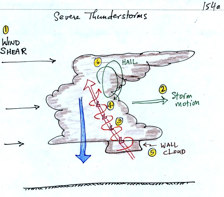
A few
details, not discussed in class, were added to the sketch of a severe
thunderstorm drawn in class on Tuesday. The tilted updraft will
sometimes begin
to rotate. A rotating
updraft is
called a mesocyclone (pt. 4). Meso refers to medium size (thunderstorm size)
and cyclone
means winds spinning around low pressure. Low pressure in the
core of the
mesocyclone creates an inward pointing
pressure
gradient force needed to keep the updraft winds spinning in circular
path (low
pressure also keeps winds spinning in a tornado). The cloud that
extends
below the cloud base and surrounds the mesocyclone
is
called a wall cloud (pt. 5). Later in class today we'll see why
this extra bit of cloud is able to form below the base of the rest of
the thunderstorm. The largest and strongest tornadoes
will
generally come from the wall cloud.
Here's a
pretty nice photograph of a wall cloud and what is probably a
relatively weak tornado (from the University
Corporation for Atmospheric Research)
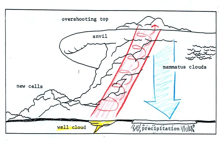
This
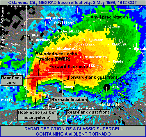
seemed like a good place to briefly discuss supercell thunderstorms.
Here is a
relatively simple
drawing showing some of the key features on a supercell
thunderstorm. In a supercell the
rotating
updraft (shown in orange above) has enough upward momentum to penetrate
into the
stratosphere. This produces the overshooting top or dome feature
above. A wall cloud and a tornado are shown at the bottom of the mesocyclone. In an ordinary air mass
thunderstorm
the updraft
is unable to penetrate into the very stable air in the stratosphere and
the
upward moving air just flattens out and forms an anvil. The
flanking line
is a line of new cells trying to form alongside the supercell
thunderstorm (existing winds converge with winds from the thunderstorm
downdraft along a gust front).
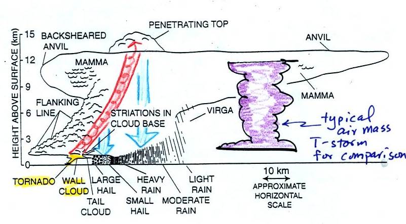
Here
is a second slightly more complicated drawing of a supercell
thunderstorm. A typical air mass thunderstorm (purple) has been
drawn in
for comparison.
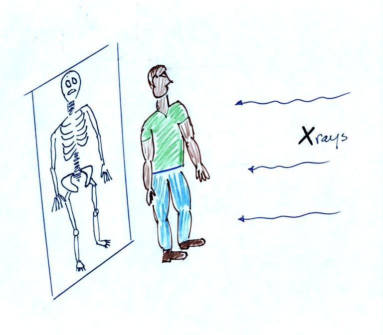
Thunderstorms
with rotating updrafts often have a distinctive radar signature.
We haven't
discussed weather radar
in this class. In some ways a radar image of a thunderstorm is
like an
X-ray photograph of a human body. The Xrays
pass through the flesh but are partially absorbed by bone.
The
radio signals
emitted by radar
pass through the cloud itself but are reflected by the much larger
precipitation particles. The intensity of the reflected signal
(the echo) is color coded. Red means an intense reflected signal
and lots of large precipitation particles. The edge of the cloud
isn't normally seen on the radar signal.
Thunderstorms
with
rotating
updrafts
produce
a
very characteristic hook
shaped echo (hook echo) on
radar.
Here
are a couple of examples:
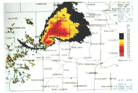
This is
the radar image of a thunderstorm that produced a very strong tornado
that hit Oklahoma
City in May
1999
. The hook echo is visible near the lower left hand
corner of the picture. Winds in the tornado may have
exceeded 300 MPH.
A short segment
of video was shown at this point. The video first showed some
good quality video of a close tornado. This was
followed by photographs of
a distant supercell thunderstorm and photographs of the bases of nearby
supercell thunderstorms. Here you could see the spectacular wall
cloud that often forms at the base of these storms. Finally a
computer simluation showed some of the complex motions that form inside
supercell thunderstorms, particularly the tilted rotating updraft.
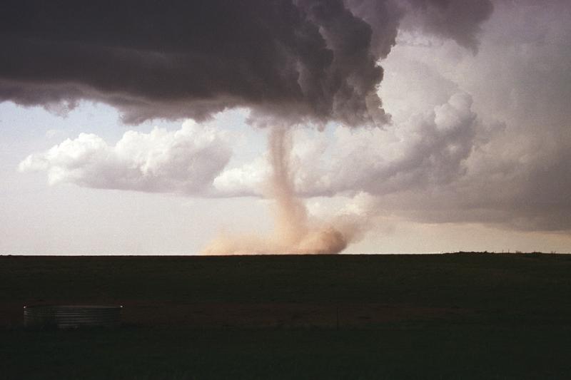
Tornadoes begin in and descend from
a
thunderstorm. You might see a funnel cloud dropping from the base
of the thunderstorm. Spinning winds will probably be present
between the cloud and ground before the tornado cloud becomes
visible. The spinning winds can stir up dust at ground
level. The spinning winds might also be strong enough at this
point to produce some minor damage. We saw an example of this in
a video tape of a tornado in Oklahoma.
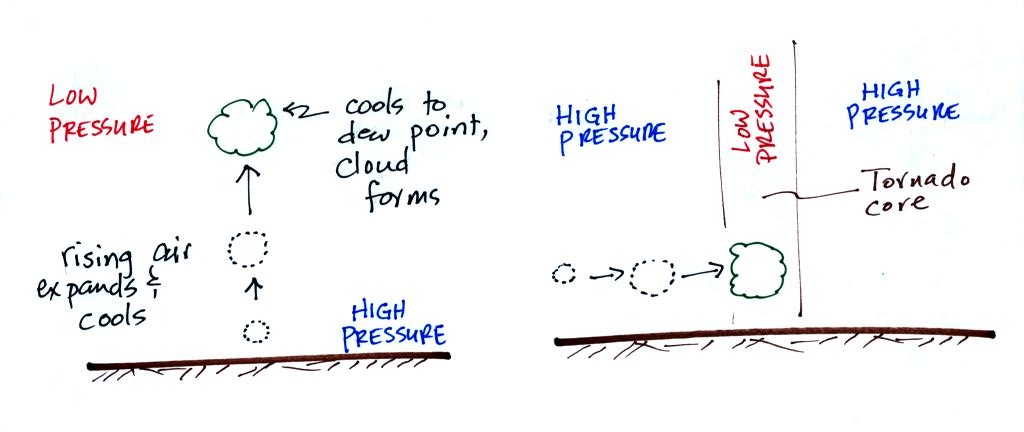
In Stage 2, moist air moves horizontally toward the low pressure
in the
core of the tornado. This sideways moving air will expand and
cool just as rising air does (see figure below). Once the air
cools enough (to the
dew point temperature) a cloud will form.
Tornadoes can go from Stage 2 to Stage 3 (this is what the
strongest
tornadoes do) or
directly from stage 2 to stage 5. Note a strong tornado is
usually vertical and thick as shown in Stage 3. "Wedge tornadoes"
actually appear wider than they are tall.
The thunderstorm and the top of the tornado will move faster than
the
surface winds and the bottom of the tornado. This will tilt and
stretch the tornado. The rope like appearance in Stage 5 is
usually a sign of a weakening (though still a dangerous) tornado.
The tornado cloud forms when moist air moves into lower
pressure
in the core of the tornado. The air expands and cools to the dew
point and a cloud forms. This is just like the cloud that forms
when air rises (and moves into lower pressure and expands). I
made an offer to students in the T Th class. If they tattoo the
figure above somewhere (especially the left side) on their body they
can use it on next week's quiz.
At about
this
point we watched a short video segment that illustrated
well the first 3 steps in the formation of a tornado (dust swirl stage
up to mature stage). The tornado was photographed near Luverne
Oklahoma in May 1991. It was eventually rated an F3 tornado.
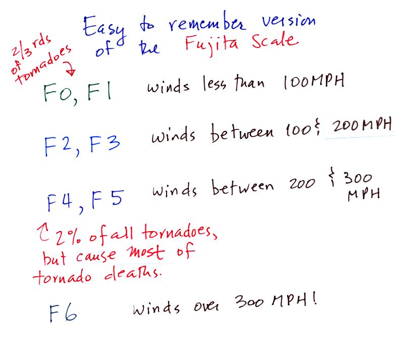
The Fujita Scale is
used to rate tornado strength and damage
potential. It is very hard to actually measure the speed of the
rotating winds in a tornado. Researchers usually survey the
damage caused by the tornado to come up with a Fujita Scale
rating. Above is a simplified, easy to remember, version of the
Fujita Scale.
This was followed by
another short video, a potpourri of images of several different
tornadoes. Descriptions of the tornadoes are given in
the table below (the numbers in the left most column were used on the
video to identify each tornado)
54a
|
F3
|
Grand
Island, NE
|
Mar.
13,
1990
|
tornado
cloud is pretty
thick and vertical
|
61f
|
F3
|
McConnell
AFB KS
|
Apr.
26,
1991
|
this
is about as close to a
tornado as you're ever likely to get. Try to judge the diameter
of the tornado cloud. What direction are the tornado winds
spinning?
|
52
|
F5
|
Hesston
KS
|
Mar.
13,
1990
|
Watch
closely,
you may see a tree or two uprooted by the tornado winds
|
51
|
F3
|
North
Platte NE
|
Jun.
25,
1989
|
Trees
uprooted
and buildings lifted by the tornado winds
|
65
|
F1
|
Brainard
MN
|
Jul.
5,
1991
|
It's
a good
thing this was only an F1 tornado
|
57
|
F2
|
Darlington
IN
|
Jun.
1,
1990
|
Tornado
cloud
without much dust
|
62b
|
F2
|
Kansas
Turnpike
|
Apr.
26,
1991
|
It's
sometimes
hard to run away from a tornado. Watch closely you'll see a van
blown off the road and rolled by the tornado. The driver of the
van was killed!
|
47
|
F2
|
Minneapolis
MN
|
Jul.
18,
1986
|
Tornado
cloud
appears and disappears. |
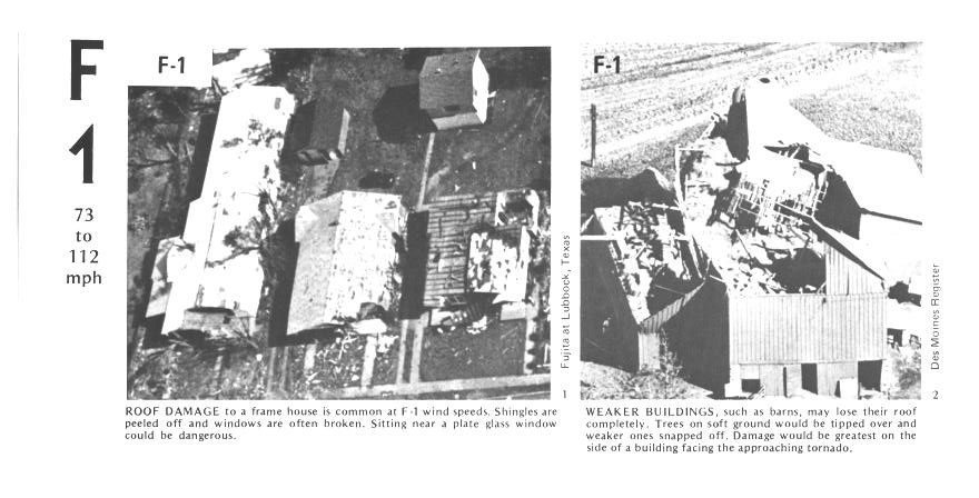
Here are some representative photographs of
tornado damage. You'll find some additional descriptions on p.
164 in the photocopied ClassNotes.
The buildings on the left suffered light roof
damage.
The barn
roof at right was more heavily damaged.
More severe damage to what
appears
to be a well built
house
roof.
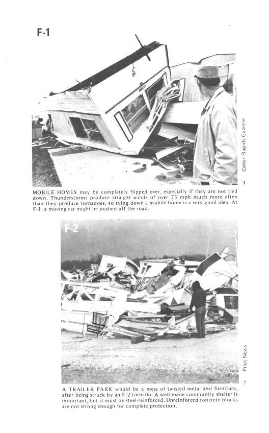
F1 tornado winds can tip over a mobile home if it is
not
tied down (the
caption states that an F1 tornado could blow a moving car off a
highway). F2 level winds (bottom photo above) can roll and
completely
destroy a
mobile home.
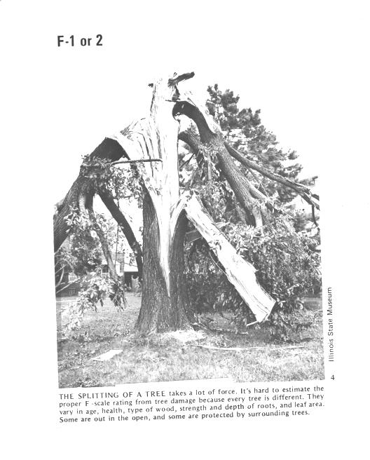
Trees, if not uprooted, can suffer serious damage from
F1 or
F2 tornado
winds.
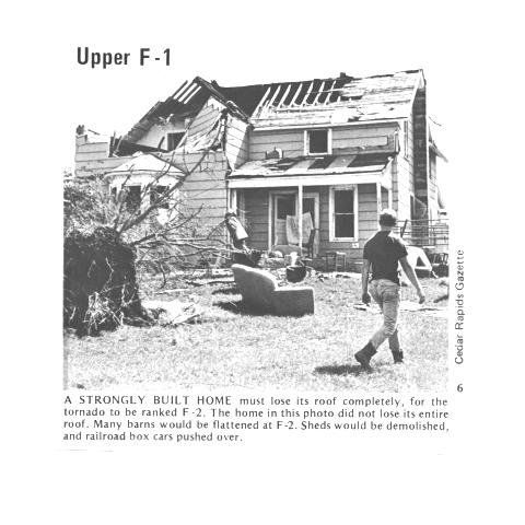
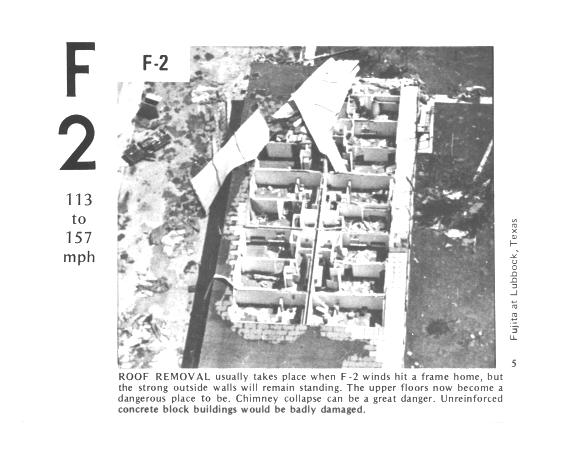
F2 level winds have completely removed the roof from
this
building. The outside walls of the building are still standing.
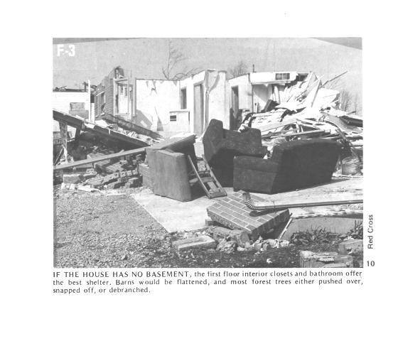
The roof is gone and the outer walls of this house were
knocked
down. This is characteristic of F3 level damage. In a house
without a basement or storm cellar it would be best to seek shelter in
an interior closet or bathroom (plumbing might help somewhat to keep
the walls intact).
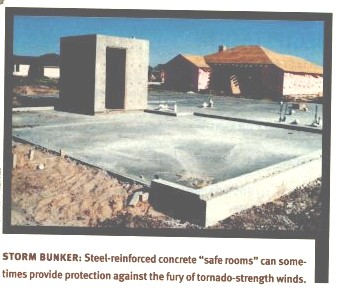
In some tornado prone areas,
people construct a small closet or room
inside their home made of reinforced concrete.
A better solution
might be to have a storm cellar located underground.
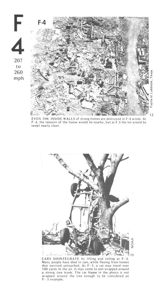
All of the walls were knocked down in the top photo but
the
debris is
left nearby. This is characteristic of F4 level damage. All
of the sheet metal in the car body has been removed in the bottom photo
and the car chasis has been bent around a tree. The tree has
been stripped of all but the largest branches.
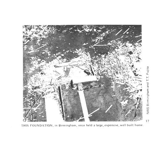
An F5 tornado completely destroyed the home in the
photo
above and
removed most of the debris.
Only bricks and a few pieces of
lumber are left.
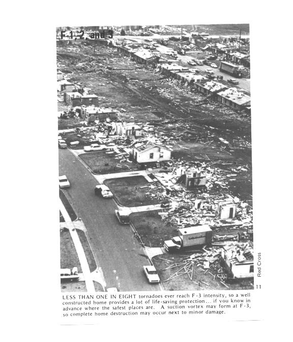
Several levels of damage are visible in the photograph
above. It
was
puzzling initially how some homes could be nearly destroyed while a
home nearby or in between was left with only light damage. One
possible explanation is shown below (from the bottom of p. 164 in the
photocopied ClassNotes.
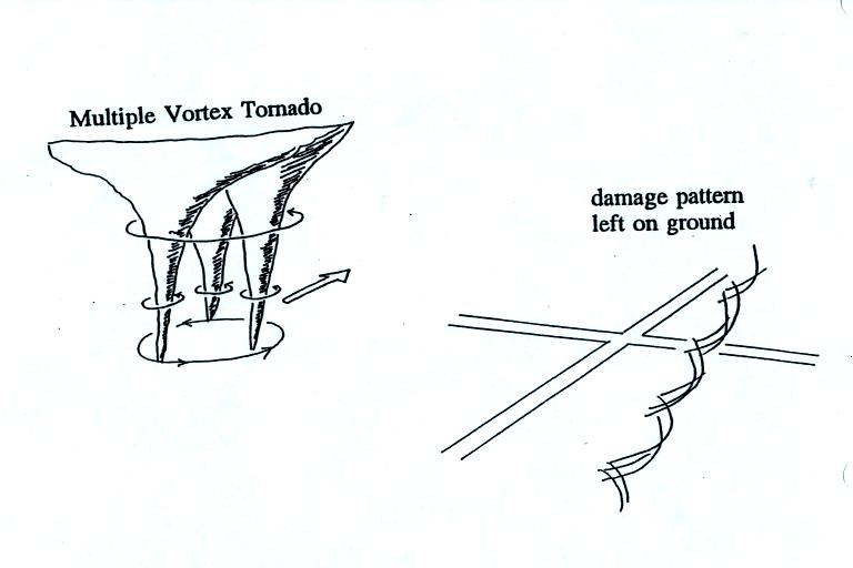
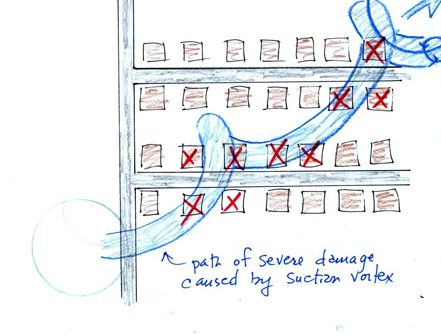
Some big
strong
tornadoes
may
have
smaller more intense "suction
vortices" that spin around the center of the tornado. Tornado
researchers have actually seen the scouring pattern shown at right in
the figure above that the multiple vortices can leave behind.
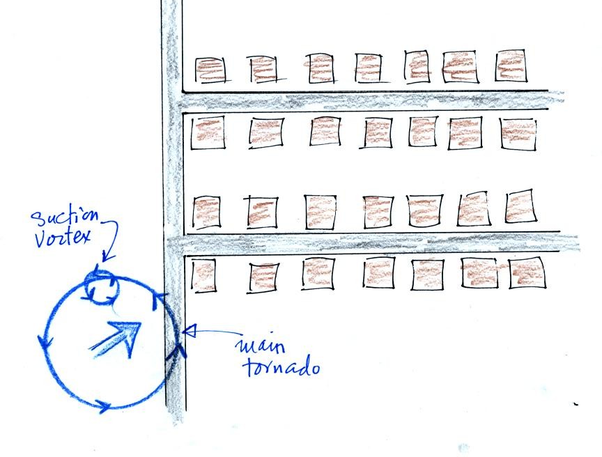
The
sketch above shows a tornado located SW of a neighborhood.
As the
tornado sweeps through the neighborhood, the suction vortex will
rotate around the core of the tornado.
The
homes marked in red would be damaged severely. The others
would receive less damage (remember, however, that there would probably
be multiple suction vortices in the tornado).
At
this point we watched the last of the tornado video tapes. It
showed a tornado that occurred in Pampa, Texas. Near the end of
the segment, video photography showed several vehicles (pick up trucks
and a van) that had been lifted 100 feet or so off the ground that were
being thrown around at 80 or 90 MPH by the tornado
winds. Winds speeds of about 250 MPH were estimated from the
video photography.