Monday Mar. 7, 2011
click here to download today's notes in a more
printer friendly format
Got to class a little early this morning so that I could play
three songs from B.B. King and Eric Clapton ("Key to the Highway",
"Worried Life Blues",
"Hold On! I'm
Coming" )
The In-class
Optional Assignment from last Friday was returned in class
today. You should have found a green
card if you asked for
one. Otherwise you received 0.5 pts of extra credit.
Today's (not so high quality) picture of the day. I
saw a larger clearer image in the current issue of Scientific
American magazine.
The item of interest is the narrow band of clouds in the center of
the picture. It is called the
Intertropical Convergence Zone. We'll learn a little more about
it today and again later in the semester. The ITCZ is not always
as clearly defined as it is in this picture. You can probably
identify it on this
current
satellite
photograph but it probably isn't as continuous a
band of clouds as in the photo above.
The Spring Equinox is just about 2 weeks away. That's
something we celebrate in NATS 101 and today seemed like a reasonable
time to review and maybe learn something new about the causes of the
seasons on the earth.
We start with three questions that any
college graduate should be able to answer (the picture below is on p.
73 in
the photocopied ClassNotes)
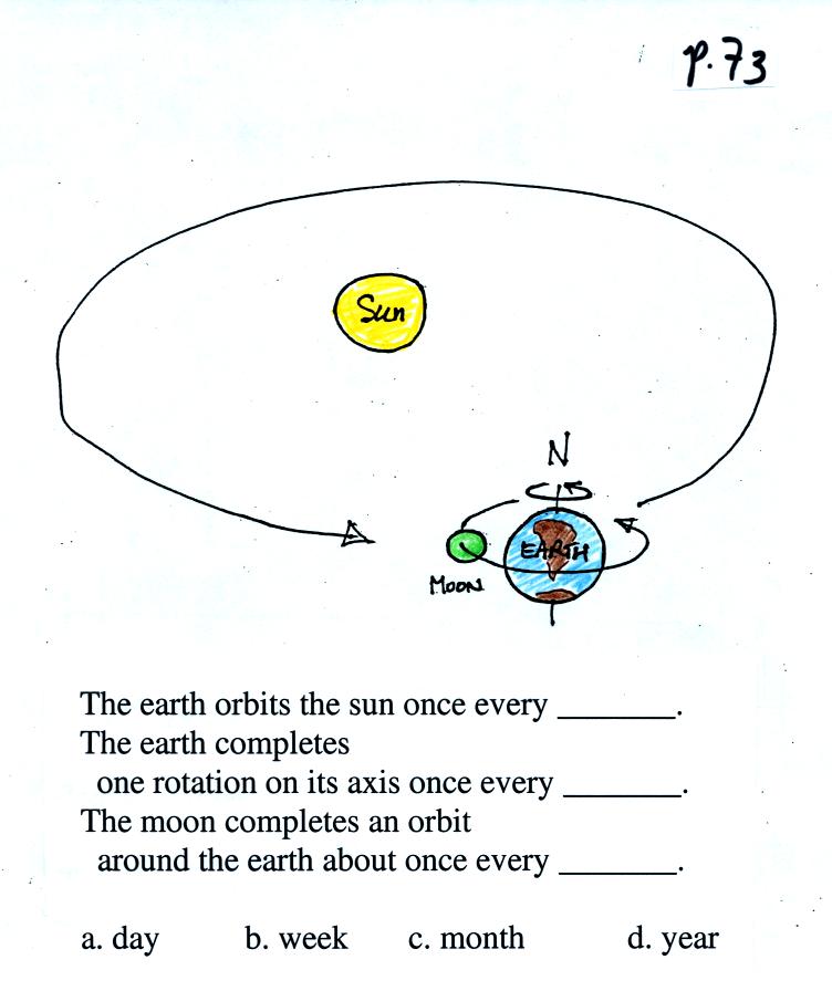
Most everyone will know the answers
to the first two questions, but not necessarily the third. Once
you think you know the answers
to the questions above, click here
The earth's orbit around the sun is
elliptical not circular. The perihelion is the point in the
earth's orbit at which it is closest to the sun. This occurs
around January 3. The aphelion is the point at which the earth is
farthest from the sun (the a in far reminds me of aphelion). This
occurs around July 4.
The real cause of the seasons is the tilt of the earth relative to the
plane of its orbit around the sun.

The north pole is tilted away from
the sun on the northern hemisphere winter solstice (it is the summer
solstice in the southern hemisphere). The north pole is tilted
toward the sun on the summer solstice in the northern hemisphere.
If you were on the far side of this picture looking back toward the
sun. Here is what you would see
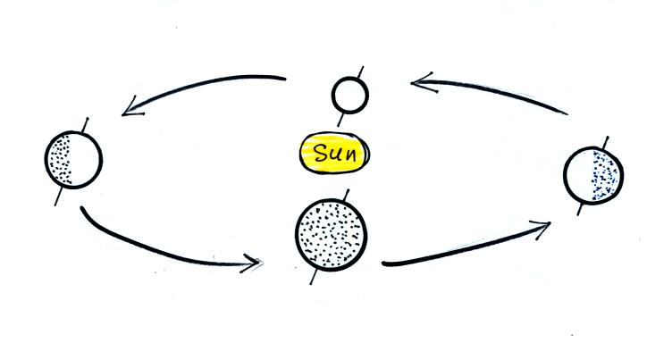
Can you identify the northern
hemisphere summer and winter solstices & the spring and fall
equinoxes in this picture?
Click here
when you think you have the
answer.
Because the earth is sometimes tilted toward the sun, sometimes away
from the sun, the angle of the sun in the sky varies during the
year. This will partly determine how much incoming sunlight makes
it to the earth's surface and how effectively it can warm the ground.
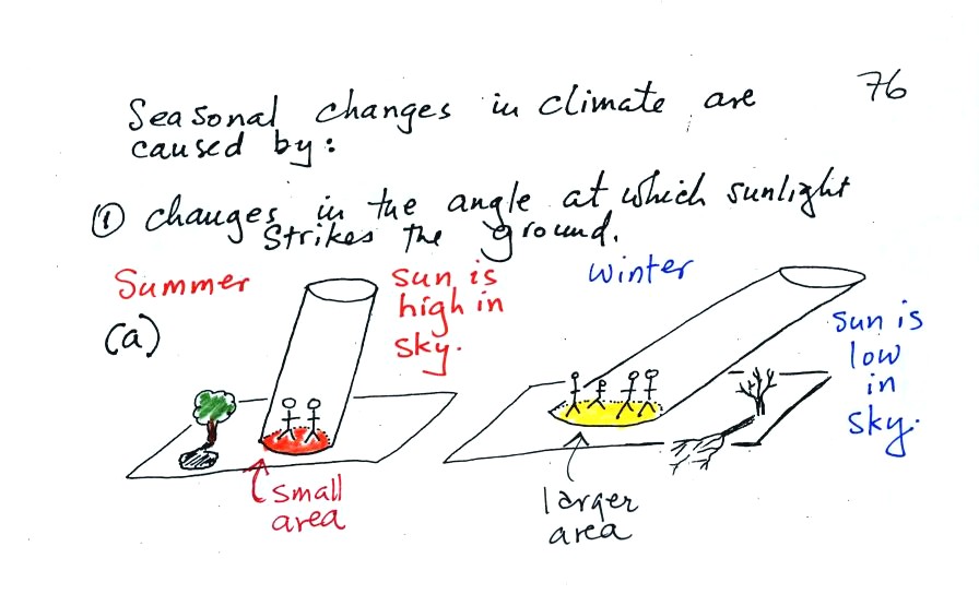
In the summer when the sun reaches a high elevation angle
above the
horizon, an incoming beam of sunlight will shine on a small area of
ground. The ground will get hot. The two people sharing the
shaft of summer sunlight will get a sunburn.
In the winter the sun is
lower in the sky. The same beam of sunlight gets spread out over
a larger area. The energy is being used to try heat a larger
amount of ground. The result is the the ground won't get as
hot. 4 people are able to share the winter sunlight and won't get
burned as quickly.
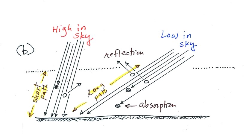
As sunlight passes through the
atmosphere it can be absorbed
or
reflected. Both prevent energy from reaching and warming the
ground. On average (over the globe) only about 50% of the
sunlight arriving at
the top of the atmosphere actually makes it to the ground. A beam
of sunlight that travels through the atmosphere at a low angle (right
picture above) is less intense than beam that passes through the
atmosphere more directly (left picture). 4 out of the 6 arrows
taking the short path through the atmosphere make it to the ground in
the left figure (67%). In the right figure only 2 of the 6
survive the trip (33%).
There's something else that changes also.

Click here
when you think you have the answer.
On the equinoxes,
the day
and night are each 12 hours long everywhere on earth (except perhaps at
the poles). On the equinoxes, the sun rises exactly in the east
and
sets
exactly in the
west. The picture below shows the position of the sun at sunrise
(around 6:30 am on the spring and fall equinox in Tucson).
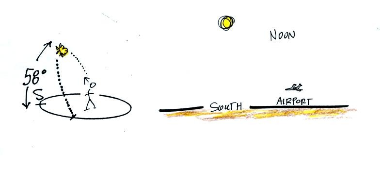
The figure at left traces out the path will follow in
the sky on the equinox. The sun rises in the east, moves to the
southern sky and begins to get higher in the sky
At noon you need to look about 60 degrees
above the
southern
horizon to see the sun. The sun is only 34.5 degrees above the
southern horizon on the winter solstice in Tucson and is
81.5 degrees
above the horizon, nearly overhead, at noon on the summer solstice.
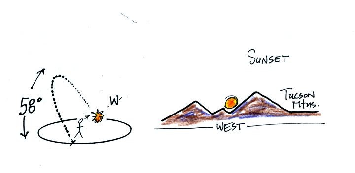
On the equinoxes the sun sets exactly in the west at
about 6:30 pm.
This is a 10 am class. Most of you are more likely
(perhaps) to see the sun set than to see the
sun
rise. The figure below shows you about what you would see if you
looked west on Speedway (from Treat Ave.) at sunset. In the
winter the sun will set south of west, in the summer north of west
(probably further south and north than shown here). On the
equinoxes the sun sets exactly in the west.
Several years ago I positioned myself in the median near the
intersecton of Treat and Speedway and pointed my camera west. I
took a multiple exposure photograph of the sun over a 2 hour period
that ended at sunset. I'll try to bring the slide photograph to
class one of these days.
If you aren't careful, you can get yourself seriously
injured,
even killed,
on
or around the equinoxes.
June 21, the summer solstice, is the longest
day
of the
year (about 14 hours of daylight in Tucson). The days start to
shorten after that. They're 12 hours long on Sept. 21, the fall
equinox and continue to get shorter until December
21,
the winter solstice, when there will be about 10 hours of
daylight. After that the days will start to lengthen as we make
our way back to
the summer solstice.
The length of the day changes most rapidly on the equinoxes.
I'm trying to resist my natural inclination to beat this topic to
death (have a look at pps 77a - 80 in the photocopied ClassNotes if you
want to see what that would entail). There are a few more points
that are worth covering however (though this remaining
material won't be on this week's quiz)
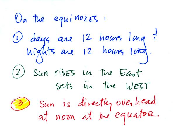
The sun passes overhead at noon on
the equinoxes on the equator. That's the 3rd main thing to
remember about the equinoxes. This is shown at the right edge of
the figure below (a portion of p. 77a in the ClassNotes).
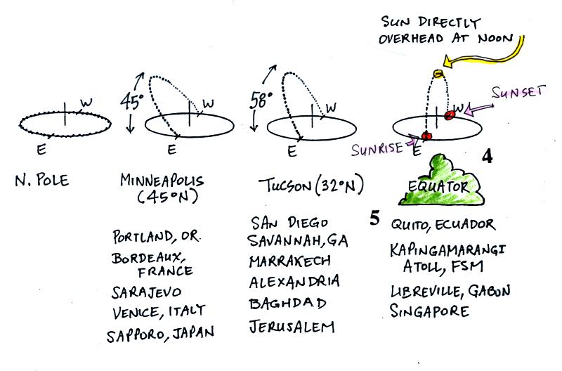
The sun rises in the east, passes
directly overhead at noon and sets in the west at the equator.
The sun also rises in the east and sets in the west (and the days are
12 hours long) in Tucson and Minneapolis but it doesn't get as high in
the sky at noon.
Now do you remember the thin band of clouds in the satellite photo at
the beginning of class. That band of clouds, the intertropical
convergence zone (ITCZ) tends to be found wherever the sun passes
directly overhead at noon. The band of clouds will be found near
the equator on the equinoxes.
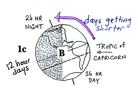
Next we'll look briefly at the winter solstice.
24 hours of night (0 hour days) at the N. Pole, 12 hour days at
the equator (that is true year round), and 24 hours of day at the S.
Pole. As you move northward from the equator toward the N. Pole
days go from being 12 hours long to eventually ending up 0 hours long
north of the Arctic Circle). Days get shorter with increasing
latitude in the N. Hemisphere.
Next some more sunpath diagrams showing the situation on the
winter solstice
In Tucson the day is only 10 hours long and the sun never gets
very high in the sky. There is less sunlight energy arriving at
the ground now that than there is at other times of the year.
That's why it's winter in Tucson in December (and in January and
February).
As you move northward from the equator, the days get even shorter and
the sun is lower in the sky at noon. The two main factors that
determine how much sunlight energy reaches the ground during the day
(angle of the sun and length of the daylight hours) are working
together and reducing the amount of sunlight as you move toward higher
latitude. It gets colder and colder as you move toward the N.
Pole.
Now we'll look at the summer solstice.
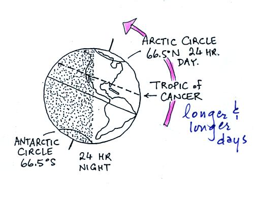
Now days are getting longer and
longer as you move north of the equator. There are 24 hours of
daylight north of the Arctic Circle on the summer solstice.
The sun passes overhead at noon at 23.5 N latitude, the Tropic of
Cancer. That's where the band of clouds moves. In Tucson
there are 14 hours of daylight and the sun is nearly overhead at
noon. That's a lot more solar energy arriving at the ground
during the day and explains why it gets so hot in Tucson in the summer.
Now note as you move northward the days get longer but the angle of the
sun is lower and lower in the sky. The two main factors that
determine how much energy arrives at the ground during the day are
working against each other. Where do you think the optimal
combination of length of day and angle of the sun in the sky
occurs? It turns out to be around 30 latitude (the big red arrow
in the figure above). That's why the hottest locations on earth
are found near 30 latitude and not at the equator.
And that's probably enough material on the causes of the seasons.


