You
must
have
access
to a toilet with water
that
spins
when
the
toilet is flushed.
Flush
the
toilet
and
make a
note of whether
the
water
spins
clockwise
or counterclockwise.
Then
either
email
me
the result or write down
the
result
on
a
piece of
paper and turn it.
No
photographs
please.
Many
of
the
toilets
on campus won't work.
The
water
doesn't
spin,
there
is just a
sudden
whoosh
as
the
water is forced down the drain.
Here
are
3
of
the responses I
got in a previous class.
We'll devote the rest of this lecture to another situation where the
Coriolis force can be neglected because it is much weaker than the
pressure gradient force.
Differences
in temperature (such as you might find between a coast
and
the ocean or between a city and the surrounding country side) can
create
horizontal pressure differences. The horizontal pressure gradient can
then produce a wind flow pattern known as a thermal circulation.
Because these are generally relatively small scale circulations,
the
pressure gradient is much stronger than the Coriolis force.
By applying some of the
concepts we learned earlier in the semester we can really understand
pretty well how thermal circulations develop.
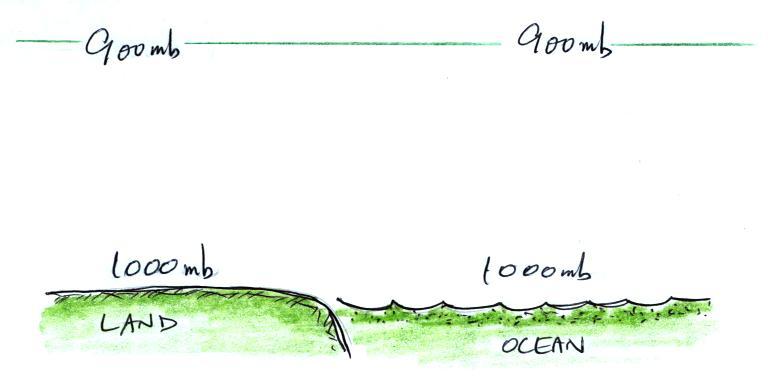
We'll
start
here
along
a sea
coast. In this picture the air temperatures and pressures on both
sides of the picture are the same.
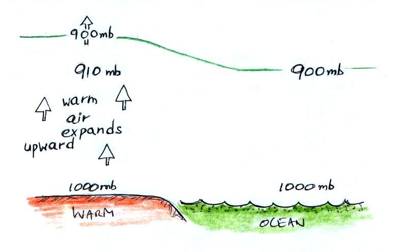
A beach will often become much warmer than the
nearby
ocean during
the day (the sand gets hot enough that it is painful to walk across in
barefeet). The warm air over the land will expand upward.
Note how the 900 mb level has moved upward in
the picture. We've left the temperature of the water the same as
it was in the earlier picture. The 900 mb level is found at the
same altitude above the ocean.The cooler air over the ocean will shrink
and move
downward. The 900 mb level drops below the level of the green
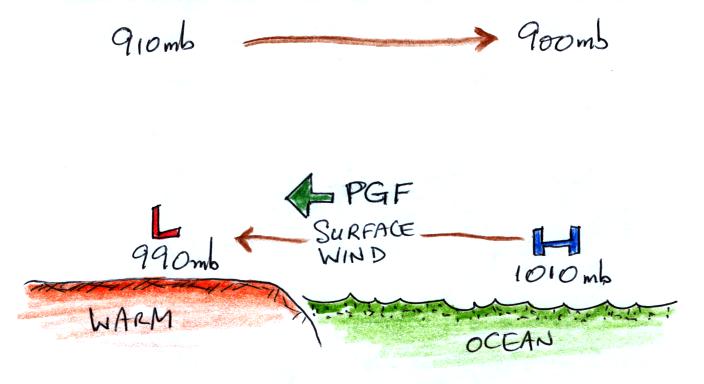
line. So on the left side of the figure we find 910 mb on the
left side and 900 mb on right (at a constant altitude above the ground).
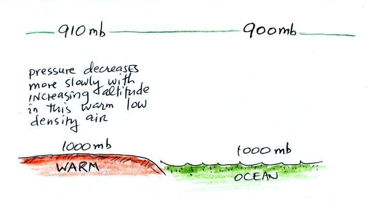
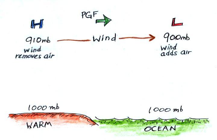
The temperature differences have created an upper level pressure
gradient (pressure difference), higher pressure (910 mb) on the left
and lower pressure (900 mb) on the right. The resulting PGF
causes air to start to blow from left to right.
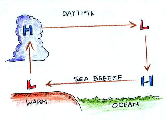
Once the air aloft begins to move it will change the surface
pressure pattern. The air aloft leaving the left side of the
picture
will lower the surface pressure (from 1000 mb to 990 mb). Adding
air at upper levels to the right side of the picture will increase the
surface
pressure (from 1000 mb to 1010 mb). Surface winds will begin to
blow from right to left.
You can complete the circulation loop by adding rising
air
above the
surface low pressure at left and sinking air above the surface high at
right. The surface winds which blow from the ocean onto land are
called a sea breeze (meteorologists try to specify where the wind is
coming from). Since this air is likely to be moist, cloud
formation is
likely when the air rises over the warm ground. Rising air
expands and cools. If you cool moist air to its dew point, clouds
form.
It is pretty easy to figure the directions of the winds in a
thermal
circulation without going through a long-winded development like
this. Just remember that warm air rises.
Draw
in
a
rising
air
arrow above the warm part of the picture, then complete the loop.
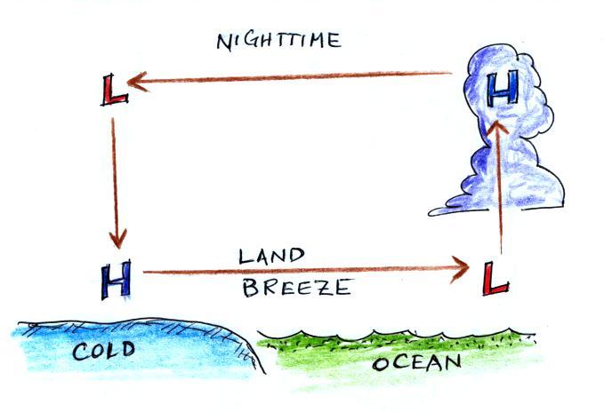
At night the ground cools more quickly than the ocean and becomes
colder than the water. Rising air is found over the warmer ocean
water (sea below). The thermal circulation pattern reverses
direction. Surface winds blow from the land out over the
ocean. This is referred to as a land breeze.
Here
are some additional examples
of thermal circulations or large scale circulations that resemble
thermal circulations.
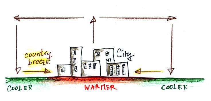
Cities are often warmer than the
surrounding
countryside,
especially at night. This is referred to as the urban heat island
effect. This difference in temperature can create a
"country breeze." This will sometimes carry pollutants
from a factory outside the city back into the city or odors from a
sewer treatment plant outside of town back into town.
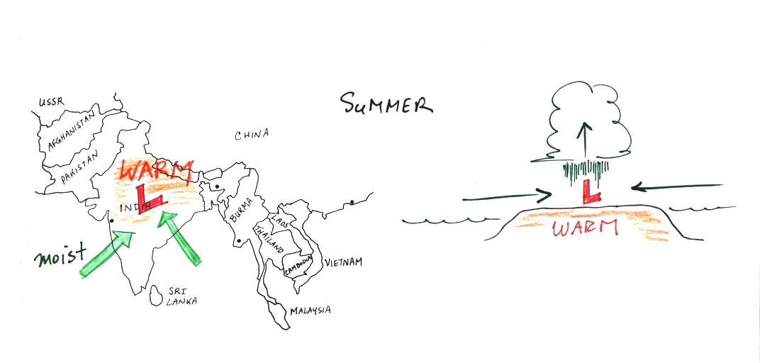
The Asian monsoon (the term monsoon refers to a seasonal change
in the direction of the prevailing winds) is a large scale circulation
pattern and is much more complex than a simple thermal
circulation. However you can
use the thermal circulation concept to get a general understanding of
what to expect at different times of the year.
In the summer India and SE
Asia
become warmer than the
oceans
nearby. Surface low pressure forms over the land, moist winds
blow from the ocean onshore, and very large amounts of rain can
follow. The view above at left is from above, the view at right
is from the side.
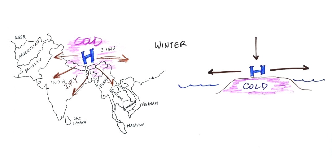
The winds change
directions in the
winter when the
land becomes colder
than the ocean.
You can
also use the thermal circulation to understand some of the basic
features of the El Nino phenomenon (you find a discussion of the El
Nino on pps 135-139 in the photocopied Classnotes).
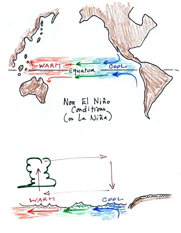
First here is what conditions look like in the tropical Pacific
Ocean
in non-El Nino years (top and side views again)
Cold ocean currents
along the west coasts of N. America and S.
American normally converge at the equator and begin to flow westward
(see top view above). As the water travels westward it
warms. Some of the warmest sea surface waters on the earth are
normally found
the western Tropical Pacific. A temperature gradient becomes
established between the W. and E. ends of the tropical Pacific. The
crossectional view above shows the normal temperature and circulation
pattern found in the equatorial Pacific Ocean. You would
find surface high pressure in the east and low pressure in the
west. Note that the wind circulation pattern is the same as the
simple thermal circulation we studied above.
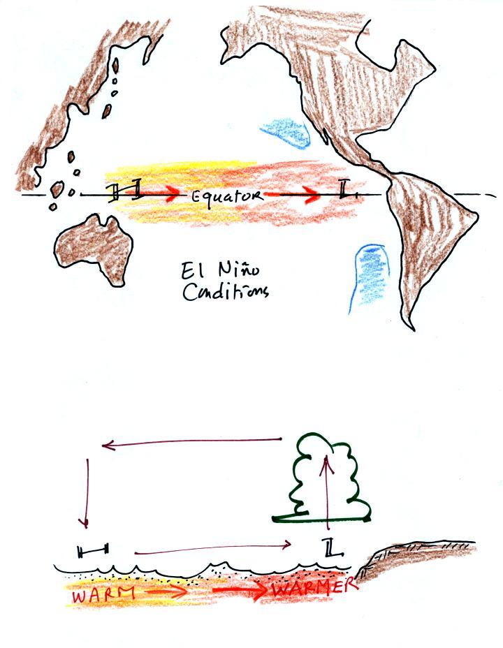
Every few years El Nino conditions occur and the cold
currents don't
make it to the
Equator. Warm water is carried from the western Pacific to the
eastern Pacific
Now surface high
pressure is found in the west and surface low
pressure and rising air is found in the E. Pacific (the reversal in the
surface pressure pattern is referred to as the southern
oscillation). Indonesia and Australia often experience drought
conditions during El Nino events. In the desert SW we expect
slightly wetter than normal conditions (perhaps 20% wetter than
normal). Wetter conditions are also found in California and in
the SE US.


