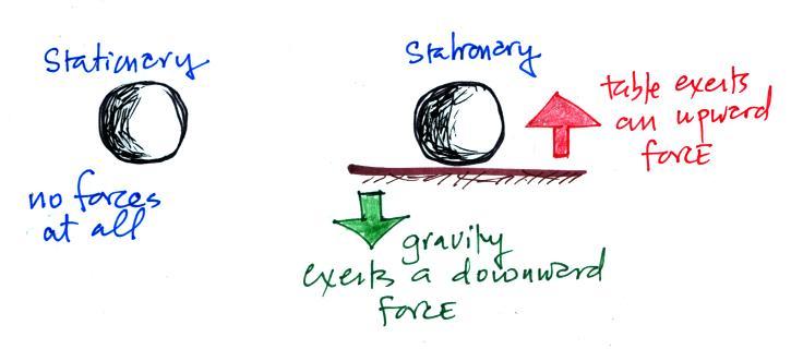
Something else to notice in the figure. Storm systems
in the tropics (0 to 30 degrees latitude) generally move from
east to west in both hemispheres. And that's something
to watch out for. We get used to things switching
directions when we move from one hemisphere to the
other. Some things do, others don't.
At middle latitudes (30 to 60 degrees), storms move in the
other direction, from west to east. To understand why
this is true we need to learn something about the earth's
global scale pressure and wind patterns. We'll get to
that next week also.
We'll be able to learn most of what we need to know about
surface and upper level winds in 10 easy steps (though I've
broken several of the steps into smaller parts)
Step #1
Here's a slightly different version of p. 122a in the
ClassNotes.
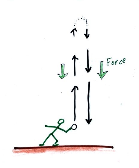
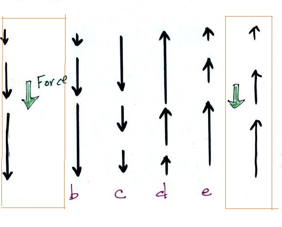
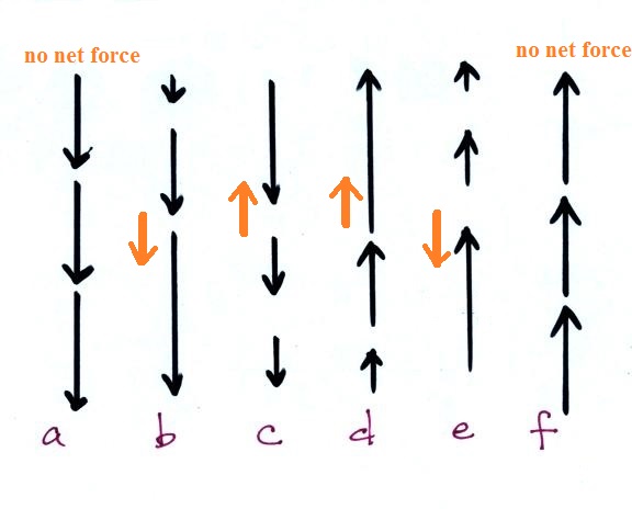
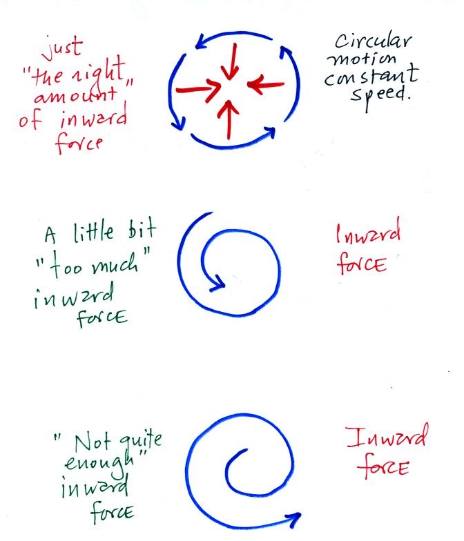
What about these three examples. Is there a
net inward or outward force in each case. You should
now know that there is a net inward force in the 1st example
because that's what we've just been covering. What
about the next two. The 3rd example usually causes
people the most trouble. You'll find the answer to
this question at the end of today's notes.
Now
we'll start to look at the forces that cause
the wind to blow.
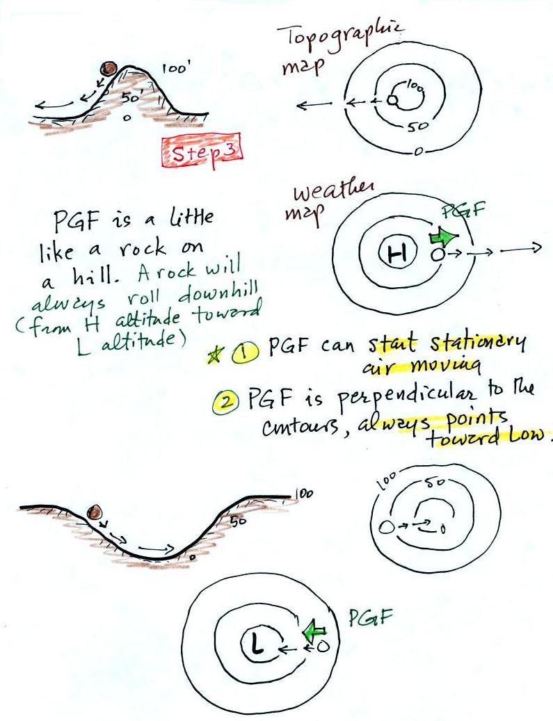
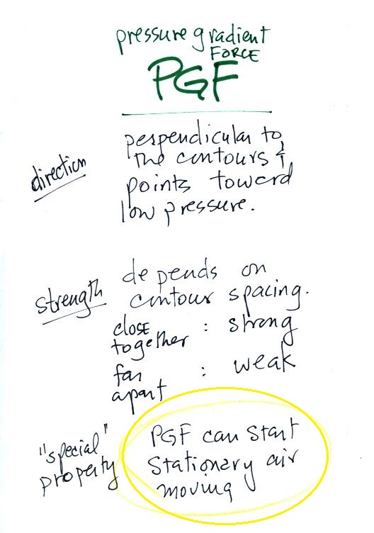
Step #3 Pressure
Gradient Force (PGF)
I didn't
actually show this figure in class (it's
on p. 123a in the ClassNotes)
Isobars on a weather map are very much like height
contours on a topographic map. A center of low pressure on
a weather map is analogous to a circular valley on a topographic
map (high pressure on a weather chart is like a circular hill).
The PGF always points in a direction that is perpendicular to
the contour lines and toward low pressure. The PGF can
start stationary air moving. The air will always start
moving toward low pressure. Air moving inward toward low
pressure or outward away from high pressure is similar to a rock
rolling downhill into the center of a valley or downhill away
from the summit of a hill.
Use the following figure to test yourself. With an arrow
draw the direction of the PGF at each of the points in the
figure. You'll find the answers at the end of today's
notes.
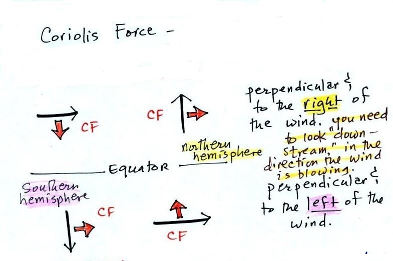
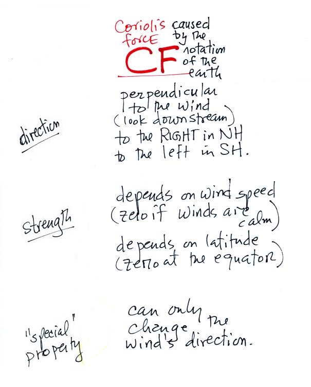
Step #4 - Coriolis force (CF)
The rules for the CF are shown below.
The top of p. in the ClassNotes has several examples showing
the direction of the CF. You can use them to check and
make sure you understand how to apply the direction rule
above.
The Coriolis force is caused by the rotation of the
earth. We'll learn more about the Coriolis force next
week. The CF points perpendicular to the wind and is to
the right or left depending on hemisphere. Be sure you
are looking in the direction the wind is blowing, looking
downstream when determining the direction of the CF.
The CF can only change the wind's direction. It can't
cause the wind to speed up or slow down.
There isn't any Coriolis force when the wind is calm.
Coriolis force is zero at the equation because that's where
the CF changes direction. Hurricanes don't form at the
equator because there is no Coriolis force there.
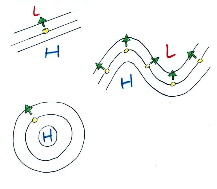
Time now to begin to apply what we've learned so far.
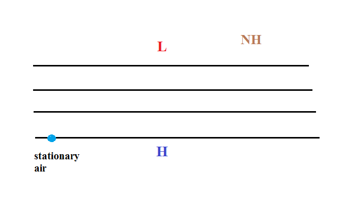
We'll consider the simplest possible situation - upper
level winds with straight contours. We'll do a
Northern Hemisphere (NH) example.
We start with some stationary air in
the lower left corner of the picture. Low pressure
is at the top and high pressure at the bottom of the
picture.
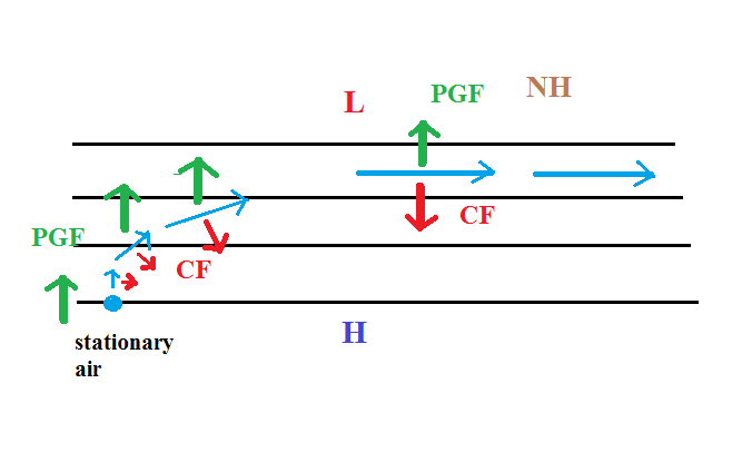
The PGF can start stationary air moving. The PGF
will point toward the top of the picture (perpendicular
to the contours and toward the low pressure at the
top). There won't be any Coriolis force when the
air is stationary.
Once the wind starts to blow (blue
line above) the CF will appear. The CF will be
weak at first because the wind speed is low but the CF
will begin to turn the wind to the right. As the
wind picks up speed the CF will increase in
strength. Eventually the wind will be blowing
parallel to the contours from left to right. The
PGF and CF point in opposite directions and are of equal
strength. The net force is zero and the wind will
continue to blow to the right in a straight line at
constant speed.
Here's a simpler less cluttered way of depicting what we
have just figured out.
The dots show the direction of the initial motion.
That will always be toward low pressure. Then you
look in the direction the wind starts to blow and look
to see if the wind turns right or left. It turned
right in this case. That's the effect of the
Coriolis force and means this is a northern hemisphere
map.
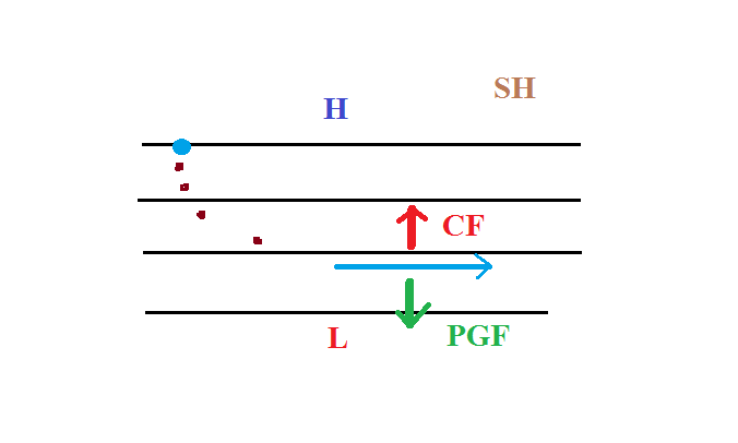
Here's one last example to test your understanding.
The direction of the initial motion is shown with
dots. Where is the high and low pressure in this
case? Is this a NH or SH chart. You'll find
the completed map at the end of today's notes.
Here are the answers to a couple of question embedded in
the notes.
A net inward force is needed in all
three cases. The thing that changes is the
strength of the inward force.
This figure shows the directions of the
PGF at each of the highlighted points. The
mistake many people make is to draw the arrow pointing
straight toward the L.
But the PGF arrow must also always be perpendicular to the
contour lines.