Thursday Apr. 16, 2015
Celtic music from Gaelic Storm "Johnny
Jump Up", "Heart
of the Ocean", "Before
the Night is Over" my personal favorite, and from De Dannan
"Hibernian
Rhapsody" played before most of the 9:30 students had
arrived.
The 1S1P reports on Rainbows, Mirages and the Green Flash were
collected today.
I came to class having graded all of the Experiment, Scientific
Paper and Book Reports in my possession. Those of you
picking up reports that were turned in last Thursday before the
quiz or Tuesday this week have to weeks to revise and resubmit
your report if you want to (it's not required). Revised
reports are due by Thu., Apr. 30.
Step #9 - Friction and
surface winds
Upper level winds blow parallel to the contour lines.
Next we'll try to understand why friction causes surface winds to
blow across the contour lines (always toward low pressure).
With surface winds we need to take into account the PGF, the CF, and
the frictional force (F). That means we'll need some rules
for the direction and strength of the frictional force.
Friction arises with surface winds because the air is blowing
across (rubbing against) the earth's surface.
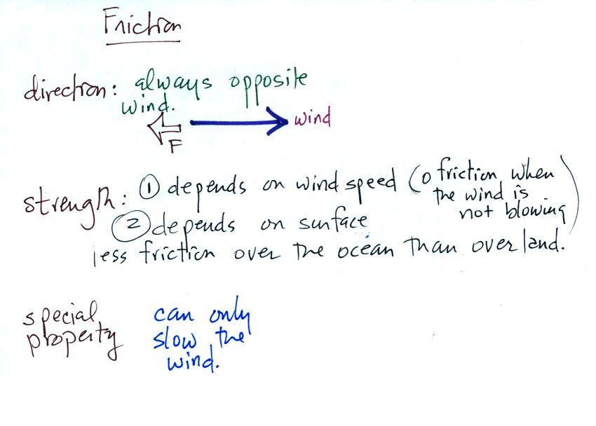
You're probably somewhat familiar with the effects of
friction. If you stop pedaling your bicycle on a flat road
you will slow down and eventually come to a stop due to air
friction and friction between the tires and road surface.
Friction always acts to slow a moving object and points in a
direction opposite the motion.
The strength of the frictional force depends on wind speed.
The faster you try to go the harder it becomes because of
increased wind resistance. It's harder to ride on a rough
road than on a smooth road surface. In the case of air there
is less friction when wind blows over the ocean than when the air
blows over land. If the wind isn't blowing there isn't any
friction.
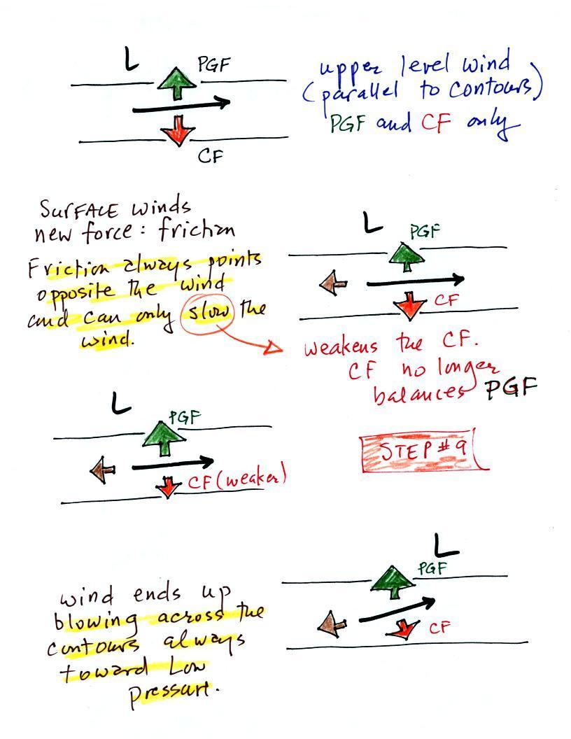
The top figure shows upper level winds blowing parallel
to straight contours. The PGF and CF point in opposite
directions and have the same strength. Note the CF is to the
right of the wind, this is a northern hemisphere case. The
total force, the net force, is zero. The winds would blow in
a straight line at constant speed.
We add friction in the second picture. It points in a
direction opposite the wind and acts to slow the wind down.
Slowing the wind weakens the CF and it can no longer balance the
PGF (3rd figure). The stronger PGF causes the wind to turn
and start to blow across the contours toward Low. This is
shown in the 4th figure.
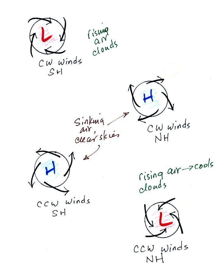
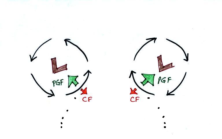
Step #10 - Surface winds (H or L pressure, S or N
hemisphere, Rising or Sinking air)
Key point to remember: surface winds blow across the
contours always toward low pressure
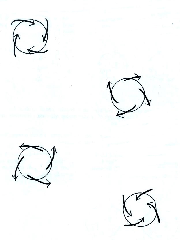
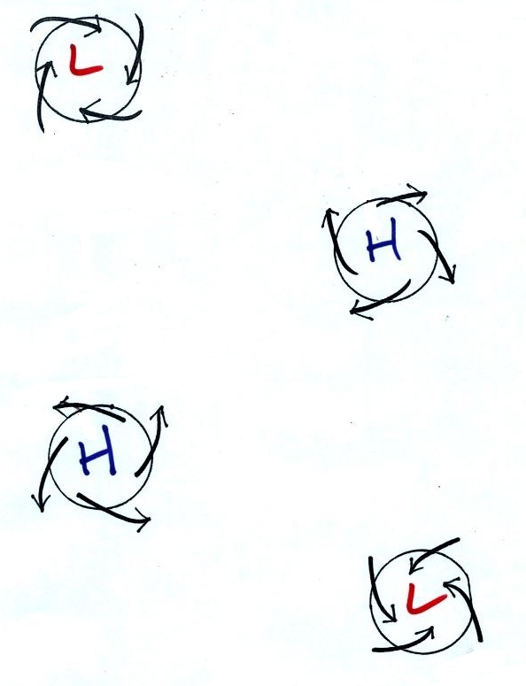
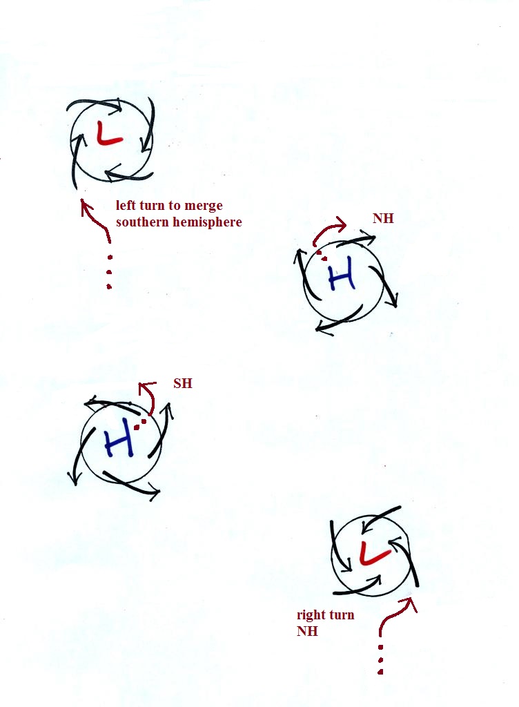
It should be very easy to figure out which two of the figures
above are surface centers of low and high pressure.
Winds blow into the centers of low pressure and outward
away from centers of high pressure.
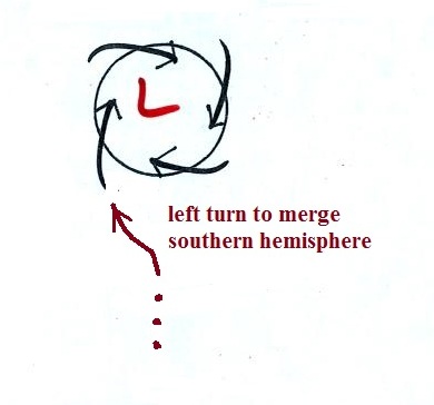
Next to determine whether each figure is in the northern or
southern hemisphere we will imagine approaching the upper left
figure in an automobile. We'll imagine it's a traffic circle
and the arrows represent cars instead of wind.
You're approaching the traffic
circle, what direction would you need to turn in order to
merge with the other cars. In this case it's
left. That left turn is the Coriolis force at work
and tells you this is a southern hemisphere map.
The remaining examples are shown below
Converging winds cause air to rise. Rising air expands and
cools and can cause clouds to form. Clouds and stormy
weather are associated with surface low pressure in both
hemispheres. Diverging winds created sinking wind motions
and result in clear skies.
Somethings change when you move form the northern to the
southern hemisphere (direction of the spinning winds).
Sometimes stay the same (winds spiral inward around centers of low
pressure in both hemispheres, rising air motions are found with
centers of low pressure in both hemispheres).
Upper level winds review
Winds spin counterclockwise around L pressure in the northern
hemisphere then switch direction and spin clockwise around L
pressure in the southern hemisphere. I think by
just remembering a couple of things you can figure this out
rather than just trying to memorize it.
Remember 1st that stationary air will start moving
toward low pressure. The dots in the figure above show
this initial movtion. Then the wind will turn to the
right or left depending on the hemisphere. This is the
effect of the Coriolis force, it turns wind to the right in
the northern hemisphere and to the left in the southern
hemisphere. The northern hemisphere winds are
shown at left in the figure above, the southern hemisphere
winds are shown at right. The inward pointing force is
always stronger than the outward force so that there is a
net inward pointing force.
The same approach can be used with H pressure. The
initial motion is again toward L pressure which is on the
outside of the picture. The winds move away from the
center then turn to the right or left depending on the
hemisphere.
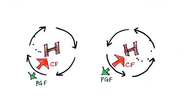
The left figure above shows winds blowing around H pressure in
the northern hemisphere.
You might have heard that water spins in a
different direction when it drains from a sink or a toilet
bowl in the southern hemisphere than it does in the northern
hemisphere. You might also have heard that this is due
to the Coriolis force or the Coriolis effect.
The Coriolis force does, as we have seen, cause winds to
spin in opposite directions around large scale high and low
pressure centers in the northern and southern
hemisphere.
Situations where the PGF is stronger than
the Coriolis force
There are situations, though, where the PGF is much stronger
than the CF and
the CF can be ignored. A tornado is an
example. Spinning water draining from a sink or toilet
is another. The PGF is much much stronger than the CF
and the CF can be ignored.
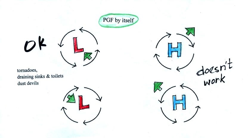
He we have clockwise and
counterclockwise spinning motions around both H and L
pressure. The direction of the PGF is shown in all
four cases (the PGF always point toward L pressure).
Remember you need an inward pointing force in order to
keep something moving in a circular path. The PGF
can provide this needed force so either clockwise or
counterclockwise motion is possible around L
pressure.
Spinning motion around H pressure isn't possible when just
the PGF is present because there isn't any inward pointing
force.
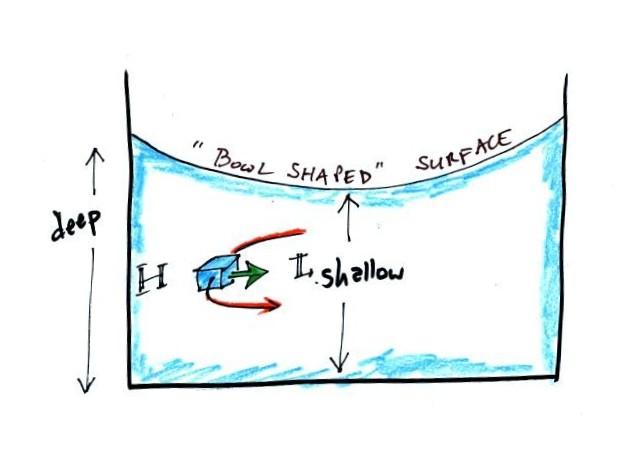
Water
draining from a sink or toilet - direction of
spin
This is what happens when water drains from a sink
or toilet. The water can spin in either
direction in either hemisphere. It might not
be obvious though what causes the inward pointing
PGF in the case of spinning water.
If you look carefully
at some spinning water you'll notice the surface has a
"bowl" or "funnel" shape as sketched above. The
water at the edges is a little deeper. That
additional water has more weight and produces more
pressure. The water in the middle is shallower,
doesn't weigh as much and the pressure is lower.
Thus there is a PGF pointing from the edges into the
center of the vortex.
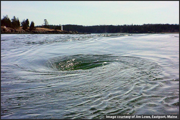
Here's a picture of the "Old Sow" whirlpool in the Bay of
Fundy it is apparently the largest whirlpool in the Western
Hemisphere (source).
We can check out this idea that water can spin in either direction
when draining from a sink or toilet with an Optional
Experiment/Assignment. Basically you'll
need to find and flush a toilet and watch what direction the water
spins. Then report your observation back to me by 5 pm this
Sunday (April 19) (you'll need to send me an email). Please
let me know which class section you are in (8 am = Sect. 2, 9:30
am = Sect. 3). I'll tabulate the results and let you know
how things turn out next week.
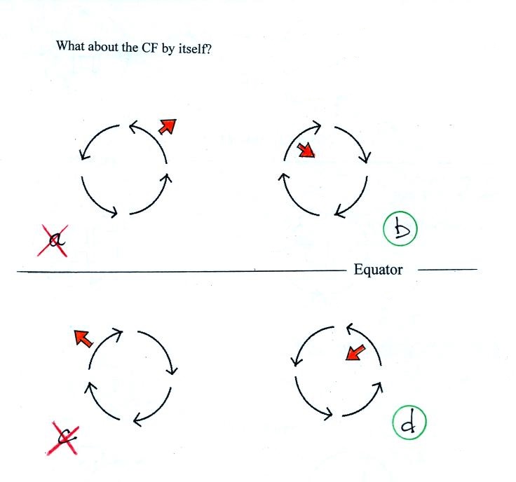
What if just the Coriolis force were present?
The following figure was on the back of the class handout.
You'll find the answer at the end of today's
notes.
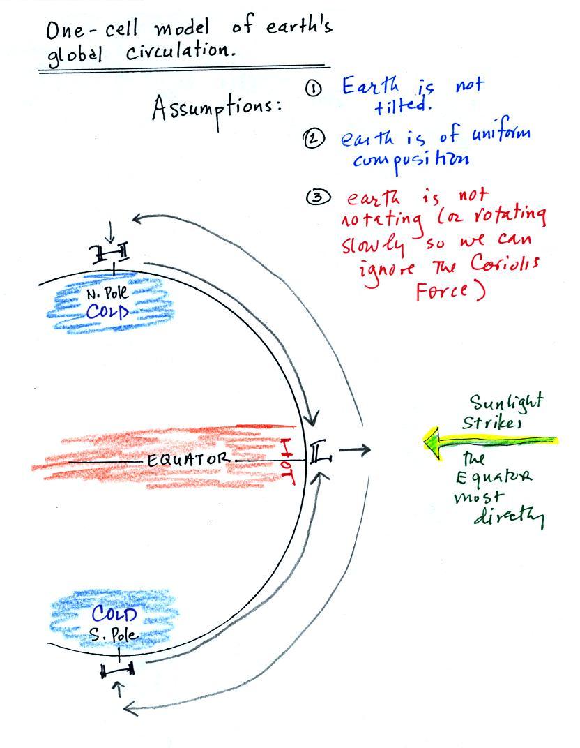
1-cell model of the earth's global scale circulation
We can use the basic concept of a thermal
circulation
to
learn about global scale pressure and wind patterns.
Ordinarily you couldn't apply a small scale phenomena like a
thermal circulation to the much larger global scale. However
if we make some simplifying assumptions, particularly if we assume
that the earth doesn't rotate or only rotates slowly, we can
ignore the Coriolis force, and a thermal circulation could become
established.
Some additional simplifications are also made and are listed
below.
Because the earth isn't tilted, the incoming sunlight
shines on the earth most directly at the equator. The
equator will become hotter than the poles. By
allowing the earth to rotate slowly we spread this warmth out in a
belt that circles the globe at the equator rather than
concentrating it in a spot on the side of the earth facing the
sun. Because the earth is of uniform composition
there aren't any temperature differences created between oceans
and continents.
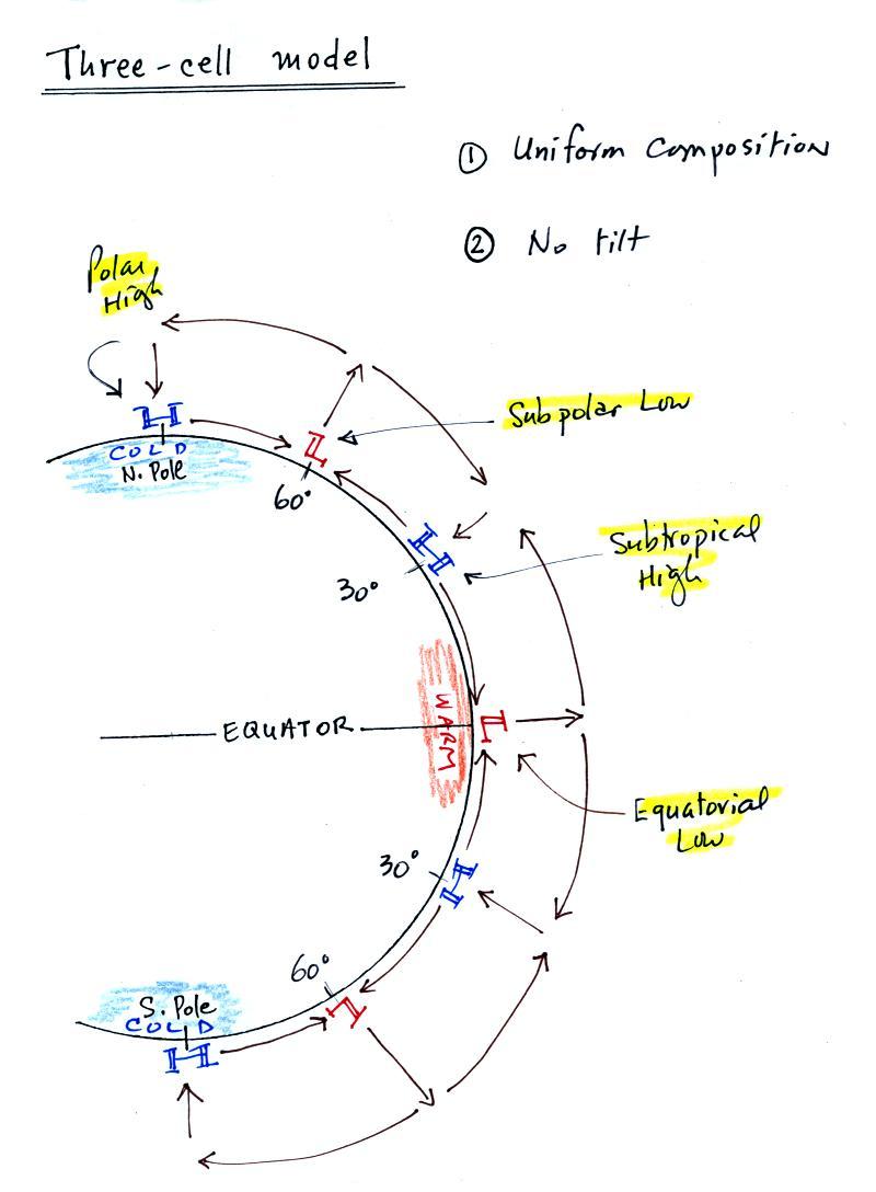
3-cell model of the earth's global scale circulation
Next we will remove the assumption concerning the rotation of the
earth. We won't be able to ignore the Coriolis force now.
This isn't something we can easily work out, we need a computer
to predict what would happen. Things are pretty much the
same at the equator in the three cell and one cell models: surface
low pressure and rising air. At upper levels the winds begin
to blow from the equator toward the poles. Once
headed toward the poles the upper level winds are deflected by the
Coriolis force. There end up being three closed loops in the
northern and in the southern hemispheres. There
are surface belts of low pressure at the equator (the equatorial low) and at
60 degrees latitude (the subpolar low). There are belts of high
pressure (the subtropical high) at 30 latitude and high pressure
centers at the two poles (the polar highs).
We will look at the 3-cell model surface features (pressure belts
and winds) in a little more detail because some of what is
predicted, even with the unrealistic assumptions, is actually
found on the earth.
Surface wind and pressure belts
Here's a map view of the region between 30 S and 30 N latitude.
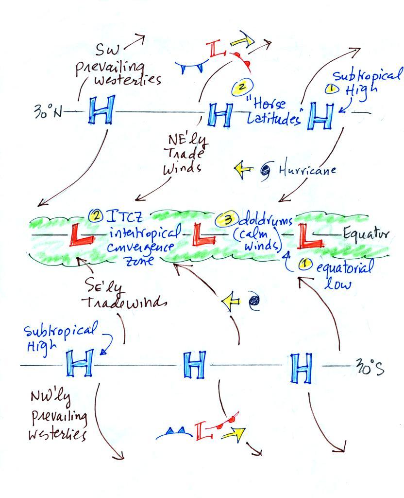
There's a lot of information on this picture, but with a
little study you should be able to start with a blank sheet of
paper and reproduce this figure. I would suggest starting at
the equator. You need to remember that there is a belt of
low pressure found there. Then remember that the pressure
belts alternate: there are belts of high pressure at 30 N
and 30 S.
Let's start at 30 S. Winds will begin to blow from High
pressure at 30 S toward Low pressure at the equator. Once
the winds start to blow they will turn to the left because of the
Coriolis force. Winds blow from 30 N toward the equator and
turn to the right in the northern hemisphere (you need to turn the
page upside down and look in the direction the winds are
blowing). These are the Trade
Winds (northeasterly trade winds north of the equator and
southeasterly trades south of the equator). They converge at
the equator and the air there rises (refer back to the
crossectional view of the 3-cell model). This is the cause of the
band of clouds that you can often see at or near the equator on a
satellite
photograph. If that link doesn't work try this
one.
The Intertropical Convergence Zone or ITCZ is another name for the
equatorial low pressure belt. This region is
also referred to as the doldrums because it is a region where
surface winds are often weak. Sailing ships would sometimes
get stranded there hundreds of miles from
land. Fortunately it is a cloudy and rainy region so
the sailors wouldn't run out of drinking water (they might well
have run out of rum though which they probably felt was worse).
Hurricanes form over warm ocean water in the subtropics between
the equator and 30 latitude. Winds at these latitudes have a
strong easterly component and hurricanes, at least early in their
development, move from east to west. Middle latitude storms
found between 30 and 60 latitude, where the prevailing westerly wind belt is found, move from
west to east.
You find sinking air, clear skies, and weak surface winds
associated with the subtropical high pressure belt. This is
also known as the horse latitudes. Sailing ships could
become stranded there also. Horses were apparently either
thrown overboard (to conserve drinking water) or eaten if food
supplies were running low. Note that sinking air is
associated with the subtropical high pressure belt so this is a
region on the earth where
skies are clear (Tucson is located at 32 N latitude, so we are
strongly affected by the subtropical high pressure belt).
The winds to the north of 30 N and to the south of 30 S are called
the "prevailing westerlies." They blow from the
SW in the northern hemisphere and from the NW in the southern
hemisphere. The 30 S to 60 S latitude belt in the southern
hemisphere is mostly ocean. Because there is less friction
over the oceans, the prevailing westerlies there can get strong,
especially in the winter. They are sometimes referred to as
the "roaring 40s" or the "ferocious 50s" (the 40s and 50s refer to
the latitude belt they are found in).
This is as far as we got in class today
and is as far as we will go on this topic.
I've put in some more information about the 3-cell model below
which I will put in the category of Optional Reading
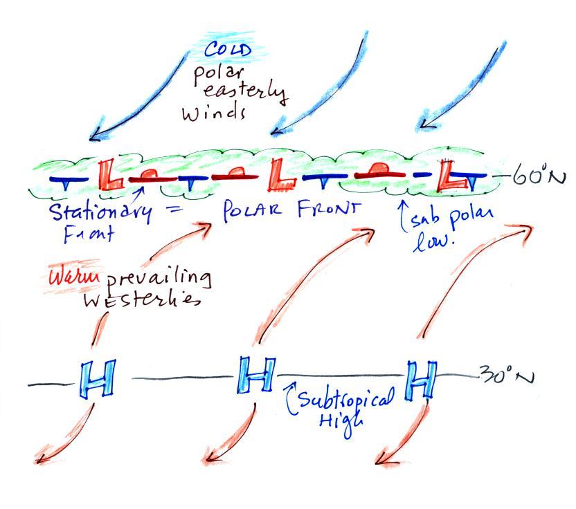
Here's the other surface map, it's a little simpler (it's a
redrawn version of what was done in class). We're just
looking from about 30 N to a little bit past 60 N. Winds
blowing north from H pressure at 30 N toward Low pressure at 60 N
turn to the right and blow from the SW. These are the
"prevailing westerlies." The polar easterlies are cold
winds coming down from high pressure at the north pole. The
subpolar low pressure belt is
found at 60 latitude. This is also a convergence
zone where the cold polar easterly winds and the warmer prevailing
westerly winds meet. The boundary between these two
different kinds of air is called the polar front and is often
drawn as a stationary front on weather maps. A strong current of winds
called the polar jet stream is found overhead. Strong middle
latitude storms will often form along the polar front.
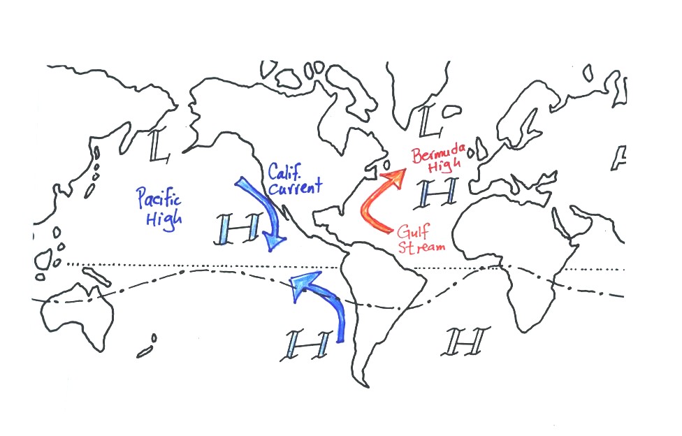
Ocean currents
The 3-cell model predicts subtropical belts of high pressure near
30 latitude. What we really find are large circular centers
of high pressure. In the northern hemisphere the Bermuda
high is found off the east coast of the US, the Pacific high is positioned off the west
coast. High pressure centers are found east and west of
South America in the southern hemisphere. Since I can't
remember their names, you don't have to either.
Circular low pressure centers, the Icelandic low (off the east
coast near Iceland and Greenland in the picture below) and the
Aleutian low (off the west coast near the southern tip of Alaska),
are found near 60 N.
The winds that blow around these large scale high pressure
centers create some of the major ocean currents of the
world. If you remember that high pressure is positioned off
the east and west coast of the US, and that winds blow clockwise
around high in the northern hemisphere, you can determine the
directions of the ocean currents flowing off the east and west
coasts of the US. The Gulf Stream is a warm current that
flows from south to north along the east coast, the California
current flows from north to south along the west coast and is a
cold current. A cold current is also found along the west
coast of South America; winds blow counterclockwise around high in
the southern hemisphere.
The SW monsoon
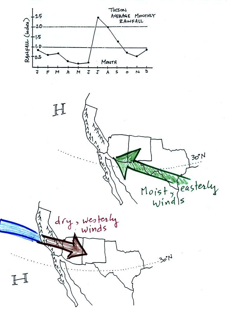
Tucson gets about 12 inches of
rain in a normal year (we are at about half of normal this
year). About half of this comes during the "summer monsoon"
season. The word monsoon, again, refers to a seasonal change
in wind direction. During the summer subtropical high
pressure (the Pacific high) moves north of its normal position
near 30 N latitude. Winds on the southhern side of the
subtropical high have an easterly component. Moist air
originating in Mexico and the Gulf of Mexico blows into
Arizona. The sun heats the ground during the day, warm moist
air in contact with the ground rises and produces convective
thunderstorms.
The close proximity of the Pacific high, with its sinking air
motions, is what gives California, Oregon, and Washington dry
summers.
In the winter the subtropical high moves south of 30 N
latitude. Winds to the north of the high blow from the
west. Air originating over the Pacific Ocean loses much of
its moisture as it crosses mountains in California (remember the
rain shadow effect). The air is pretty dry by the time it
reaches Arizona. Significant winter rains occur in Arizona
when storms systems are able to draw moist subtropical air from
the southwest Pacific ocean into Arizona.
Here's the answer to the question on
the back of the handout distributed in class today
The Coriolis force is perpendicular to the wind
and to the right in the northern hemisphere, perpendicular and
to the left in the southern hemisphere. Spinning motions
would be possible in Figs. b and d work because the
Coriolis force is pointed inward. An inward force is
needed to keep something moving in a circular path.