Friday, Mar. 25, 2016
Ruthie Foster "Set Fire to
the Rain" (4:32), "When it Don't
Come Easy" (4:18), "The Ghetto"
(5:25), "Ocean of
Tears" (3:55)
Measuring humidity with a sling psychrometer
A short discussion of how you might try to measure
humidity. One of the ways is to use a sling (swing might be
more descriptive) psychrometer.
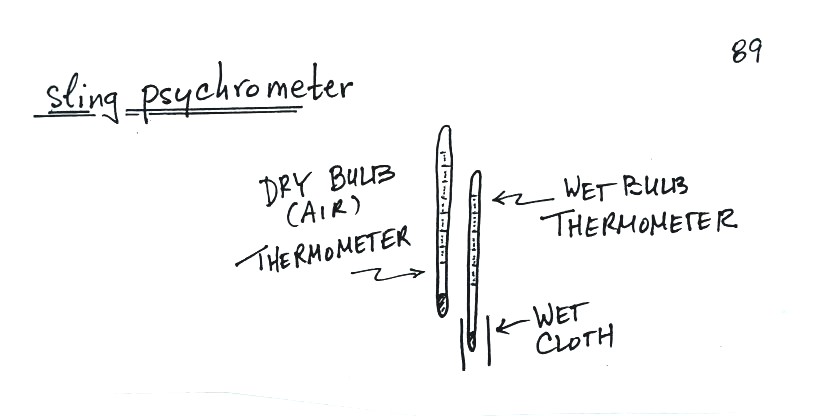
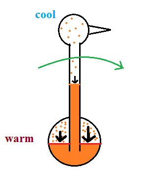
A sling
psychrometer consists of two thermometers
mounted side by side. One is an ordinary
thermometer, the other is covered with a wet
piece of cloth. To make a humidity
measurement you swing the psychrometer around
for a minute or two and then read the
temperatures from the two thermometers.
The dry thermometer measures the air
temperature.
Would the wet thermometer be warmer or colder or
the same as the dry thermometer? You
can check it out for yourself - go get one of
your hands wet. Does it feel the same as
the dry hand? You might blow on both hands
to increase the evaporation from the wet
hand. I think you'll find the wet hand
feels colder. That's what happens with the
wet bulb thermometer.
|

|
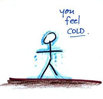
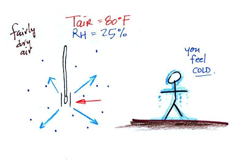
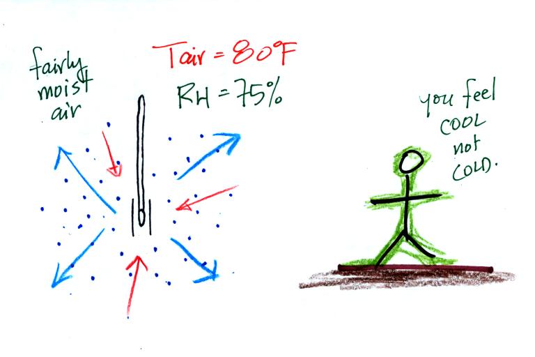
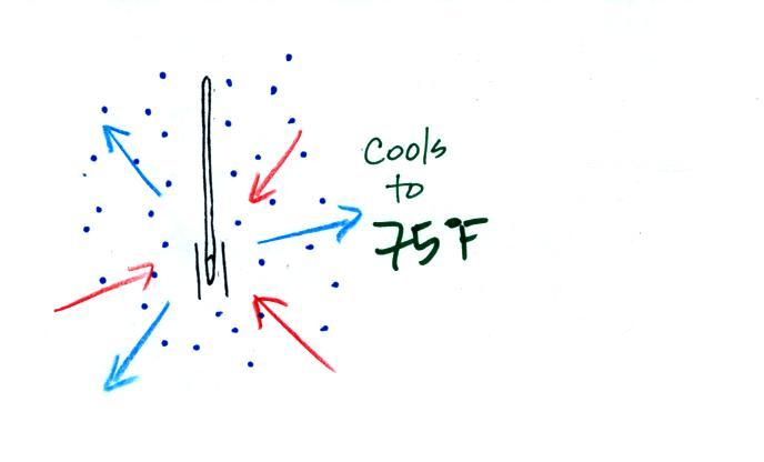
What could you say about the relative humidity in
these two situations (you can assume the air
temperature is the same in both pictures).
You would feel coldest on a dry day (the left
picture indicates dry air). The evaporative coolers
that many people use in Tucson in the summer work much
better (more cooling) early in the summer when the air is
dry. Once the thunderstorm season begins in July and
the air is more humid it is hard to cool your house below 80
F.
Here are a bunch of details that you can read through if
you're so inclined. My goal is that you understand the
basic principle behind a sling psychrometer. For that I
think you can just skip to the summary a few pictures further
on.
You need to be aware of a few things to understand the
pictures that follow:
(1) warm water evaporates more rapidly than cold water
(2) whenever there is any moisture in the air, there will be
some condensation. The rate of condensation will depend on
how much moisture is in the air
(3) these two phenomena, evaporation and condensation, operate
independently of each other
Here's the situation on a day with low relative
humidity.
The figure shows what
will happen as you start to swing the wet bulb
thermometer. Water will begin to evaporate
from the wet piece of cloth. The amount
or rate of evaporation will depend on the water
temperature Warm water
evaporates at a higher rate than cool water (think
of a steaming cup of hot tea and a glass of ice
tea).
The evaporation is shown as blue arrows because this
will cool the thermometer. The water on
the wet thermometer starts out at 80 F and
evaporates fairly rapidly.
The figure at upper left also shows one arrow of
condensation. The amount or
rate of condensation depends on how much water
vapor is in the air surrounding the
thermometer. In this case (low relative
humidity) there isn't much water vapor. The
condensation arrow is orange because the
condensation will release latent heat and warm the
thermometer.
Because there
is more evaporation (4 arrows) than
condensation (1 arrow) the wet bulb
thermometer will drop. As the
thermometer cools the rate of evaporation
will decrease. The thermometer will
continue to cool until the evaporation has
decreased enough that it balances the
condensation.
The
rates of
evaporation
and
condensation
are
equal.
The
temperature
will now
remain
constant.
The
figure below
shows the
situation on a
day with
higher
relative
humidity.
There's
enough
moisture in
the air to
provide 3
arrows of
condensation.
The rate of evaporation stays the same, the
rate of condensation is higher. The rate of
evaporation is still higher than condensation but not by
much.
There'll
only be a little cooling before the
evaporation is reduced enough to be in
balance with condensation.
Here's a visual summary
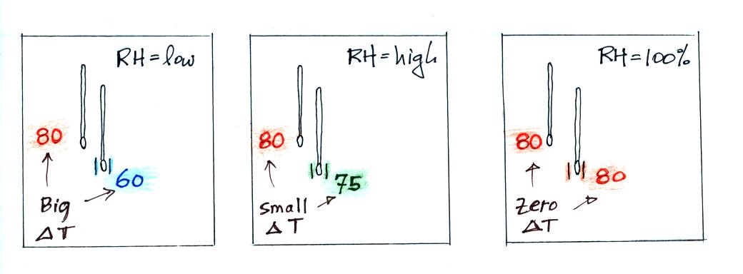
A large difference between the
dry and wet temperatures means the relative humidity
is low. A
small difference means the RH is higher. No
difference means the relative humidity is
100%.
We saw the same kind of relationship between RH and the
difference between air and dew point temperature.
Wind chill and heat index

Cold temperatures and wind make it feel
colder than it really is. The wind
chill temperature tells you how much colder it will feel (
a thermometer would measure the same temperature on both the
calm and the windy day). If your body isn't able to keep
up with the heat loss, you can get hypothermia
and die.
There's something like that involving heat
and humidity. High temperature and high humidity makes it
feel hotter than it really is. Your body tries to stay
cool by perspiring. You would feel hot on a dry 105 F
day. You'll feel even hotter on a 105 F day with high
relative humidity because your sweat
won't evaporate as quickly.
The heat
index measures how much hotter you'd feel. The combination
of heat and high humidity is a serious, potentially deadly,
weather hazard because it can cause heatstroke
(hyperthermia).
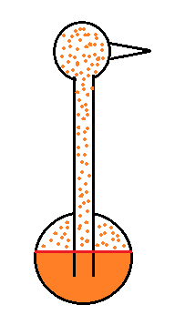
The drinking bird
Evaporative cooling and saturation are involved in the
"drinking bird".
I'm very proud of the bird I found
online. It is about twice as big as what you
normally find. The bird is filled with a volatile
liquid of some kind (ether?). Initially the bird's
head and butt are the same temperature. The liquid
inside the bird evaporates and saturates the
air inside with vapor.
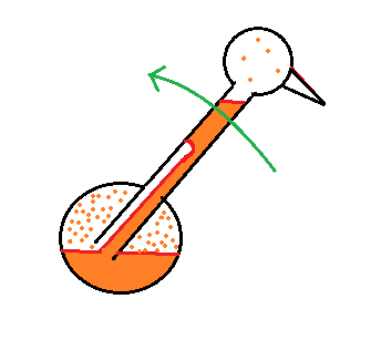
Next you get the bird's head wet. Instead of water I
cheat a little bit and use isopropyl alcohol (rubbing
alcohol) because it evaporates more rapidly than
water. The evaporation of alcohol, just as with water,
cools the bird's head.
As we saw last week, the saturation mixing ratio
(saturation vapor concentration) of water depends on
temperature. Warm air can contain more water vapor
than colder air. The same applies to the ether
vapor in this case. The head is still saturated
with vapor but there is less vapor in the cool head than
there is in warm saturated air in the bird's butt.
The differences in amounts of vapor
produce pressure differences. The higher
pressure at the bottom pushes liquid up the stem of
the bird. The bird becomes top heavy and starts
to tip.
At some point the bottom end of the stem comes out
of the pool of liquid at the base. Liquid drains
from the neck and the bird straightens up.
You can arrange the bird so that when it tips its beak dips
into a small cup of water (or alcohol). This keeps the
head moist and cool and the dipping motion could go on
indefinitely. Here's a
video.
We took away the bird's supply of alcohol, the bird warmed up
and stopped tipping.
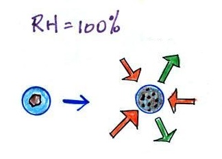
Condensation nuclei and the formation of
dew, frost, haze, fog, and clouds
Here's a visual summary of a part of what we'll be
covering next.
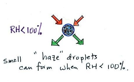
A variety of things can happen when you cool air to the dew
point and the relative humidity increases to 100%. When
moist air next to the ground becomes saturated (RH reaches 100%)
water vapor condenses onto (or, in the case of frost, is deposited
onto) the ground or objects on the ground. This forms dew,
frozen dew, and frost.
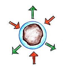
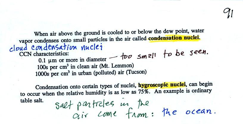
When air above the ground cools to the dew point, it is much
easier for water vapor to condense onto small particles in the air
called condensation nuclei. It would be much more difficult
for the water vapor to condense and form small drops of pure
water. Both the condensation nuclei and the small water
droplets that form on them are usually too small to be seen with
the naked eye. We can tell they are present because they
scatter sunlight and make the sky hazy. As humidity
increases dry haze turns to wet haze and eventually to fog.
We'll try to make a cloud in a bottle and you'll be able to better
appreciate the role that condensation nuclei play.
In the second half of the class we will begin to learn how to
identify and name clouds.
Condensation nuclei and the role they play in cloud
droplet formation
The air next to the ground cools during the night.
Sometimes it cools enough to reach the dew point. Water
vapor condenses onto objects on the ground and you find everything
covered with dew (or frost) the next morning. When this
happens in the air up above the ground you might think that water
vapor would simply condense and form little droplets. This
is not the case; we will find that small particles in the air
called condensation play an essential role in cloud (and fog)
formation.
it is much
easier for water vapor
to condense onto small particles
called condensation nuclei |
it would be
much harder for
water vapor
to just condense and form
small droplets of pure water
|
We didn't go into all of the details
that follow in class, though they aren't hard to figure out
and understand. If you'd prefer to just skip the
details, just remember that particles make it easier for cloud
droplets and clouds to form.
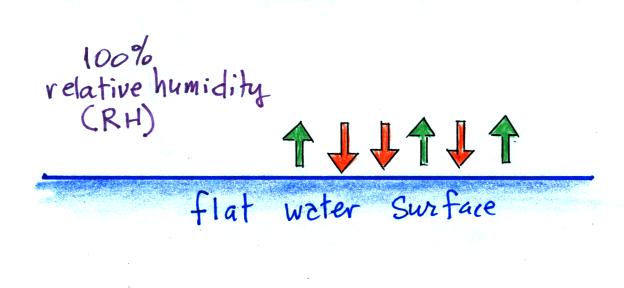
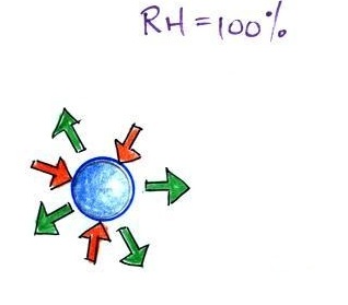
When the air is saturated
with water vapor (the relative humidity is 100%) the rates
of evaporation and condensation above a flat
surface of water will be equal.
There's no real reason for picking
three arrows each of evaporation and condensation, the
important point is that they are equal when the RH is
100%.
It's hard for water vapor to condense and form a small
droplet of water because small droplets evaporate at a very
high rate. This is known as the curvature effect and is
illustrated below.
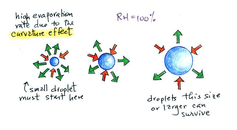
The surface of the smallest droplet above at left has the most
curvature and the highest rate of evaporation (6 arrows). If
a small droplet like this were to form, it wouldn't stay around
very long. With it's high rate of evaporation it would
quickly evaporate away and disappear.
The middle droplet is larger and would stick around a little
longer because it does not evaporate as quickly. But it too
would eventually disappear.
The drop on the right is large enough that curvature no longer has
an effect. This drop has an evaporation rate (3 arrows) that
is the same as would be found over a flat surface of water.
A droplet like this could survive, but the question is how could
it get this big without going through the smaller sizes with their
high rates of evaporation. A droplet must
somehow reach a critical size before it will be in equilibrium
with its surroundings.
Particles in the air, cloud condensation nuclei (CCN), make it
much easier for cloud droplets to form. The
figure below explains why.
By condensing onto a particle, the water droplet starts out
large enough and with an evaporation rate low enough that it is in
equilibrium with the moist surroundings (equal rates of
condensation and evaporation).
There are always lots of CCN (cloud condensation nuclei in the
air) so this isn't an impediment to cloud formation. The
following information is from p. 91 in the ClassNotes.
Now back to
material that we did cover in class.
Note that condensation onto
certain kinds of condensation nuclei and growth of cloud
droplets can begin even when the relative humidity is below
100%. These are called hygroscopic nuclei. Salt
is an example; small particles of salt mostly come from
evaporating drops of ocean water.
Here are some more of the details that
we didn't cover in class. To understand
how this can occur we first need to learn about the solute
effect
|
|
solution droplet
|
pure water droplet
|
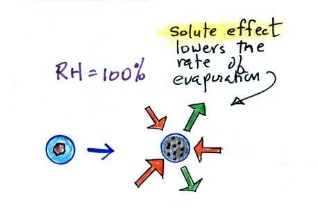
Water vapor condensing onto the
particle in the left figure dissolves the particle. The
resulting solution evaporates at a lower rate (2 arrows of
evaporation). A droplet of pure water of about the same size
would evaporate at a higher rate (4 arrows in the figure at
right). Note the rates of condensation are equal in both
figures above. This is determined by the amount of moisture
in the air surrounding each droplet. We assume the same
moist (the RH is 100%) air surrounds both droplets and the rates
of condensation are equal.
The next figure compares solution droplets that form when the
RH is 100% (left figure) and when the RH is less than 100%.
|
|
the droplet is able to
grow
|
the droplet is in
equilibrium with its surroundings
even when the RH is less than 100%
|
The solution droplet will grow in the RH=100% environment at
left. You can tell the RH is less than 100% in the figure at
right because there are now only 2 arrows of evaporation.
But because the solution droplet only has 2 arrows of evaporation
it can form and be in equilibrium in this environment.
Back again to material covered in class
The following figure is at the bottom of p. 91 in the
ClassNotes and illustrates how cloud condensation
nuclei and increasing relative humidity can affect the appearance
of the sky and the visibility.
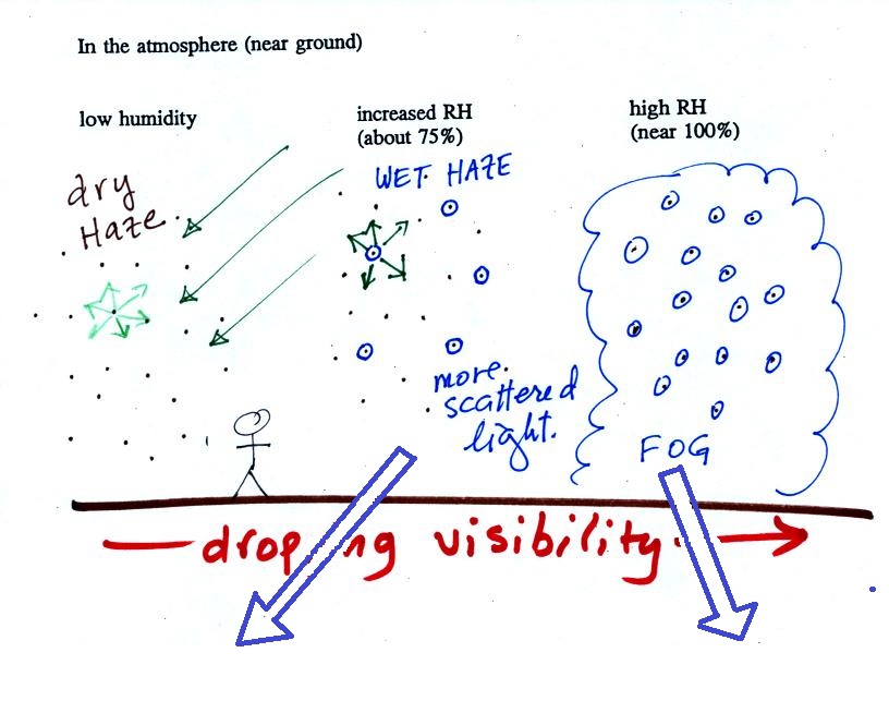
The air in the left most figure is relatively dry. Even
though the condensation nuclei particles are too small to be seen
with the human eye you can tell they are there because they
scatter sunlight. When you look at the sky you see the deep
blue color caused by scattering of sunlight by air molecules mixed
together with some white sunlight scattered by the condensation
nuclei. This changes the color of the sky from a deep blue
to a bluish white color. The more particles there are the
whiter the sky becomes. This is called "dry haze."
Visibility under these conditions might be anywhere from a few
miles up to a few tens of miles.
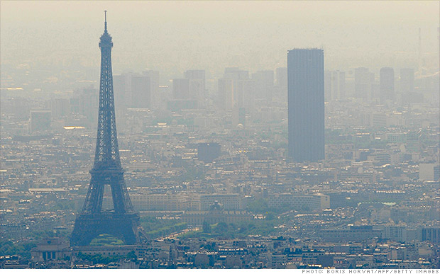
A photograph of fairly severe air pollution in
Paris that illustrates an extreme
case of dry haze (this is more common and
more severe in China). In Paris cars with even
numbered license plates weren't allowed into the city on certain
days of the week, odd numbers were banned on other days.
Public transportation was free for a short time to try to reduce
automobile use.
The middle picture below shows what happens when you drive from
the dry southwestern part of the US into the humid southeastern US
or the Gulf Coast. One of the first things you would notice
is the hazier appearance of the air and a decrease in
visibility. It isn't that there are more particles.
The relative humidity is higher, water vapor begins to condense
onto some of the condensation nuclei particles (the hygroscopic
nuclei) in the air and forms small water droplets. The water
droplets scatter more sunlight than just small particles
alone. The increase in the amount of scattered light is what
gives the air its hazier appearance. This is called "wet
haze." Visibility now might now only be a few miles.
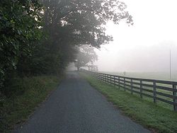
|
|
Thin fog
(perhaps even wet haze)
with pretty good visibility
(source
of the image)
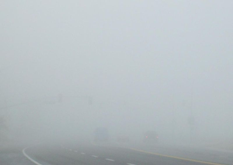
|
Thick
fog
(visibility was less than 500 feet)
(source
of the image)
|
Finally when the relative humidity increases to 100% fog forms
and water vapor condenses onto all the condensation nuclei.
Fog can cause a severe drop in the visibility. The thickest
fog forms in dirty air that contains lots of condensation
nuclei. That is part of the reason the Great London Smog of
1952 was so impressive. Visibility was at times just a few
feet!
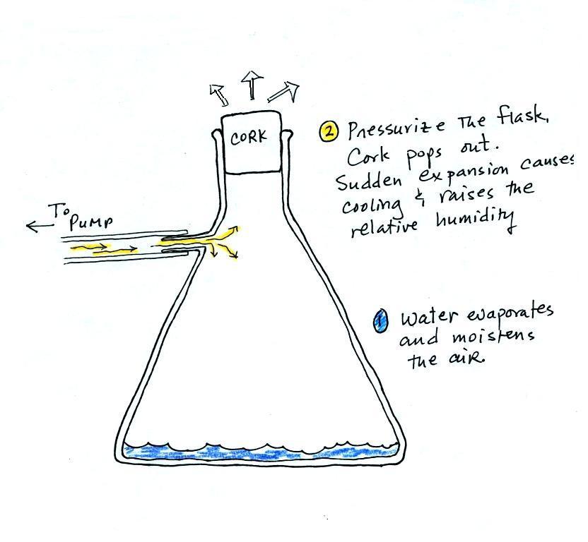
Making a cloud in a bottle
Cooling air & increasing relative humidity, condensation
nuclei, and scattering of light
are all involved in this demonstration.
We used a
strong, thick-walled, 4 liter vacuum flask (designed
to not implode when all of the air is pumped out of
them, they really aren't designed to be
pressurized). There was a little water in the
bottom of the flask to moisten the air in the
flask. Next we pressurized the air in the
flask with a bicycle pump. At some point the
pressure blows the cork out of the top of the
flask. The air in the flask expands outward
and cools. This sudden cooling increases the
relative humidity of the moist air in the flask to
more than 100% momentarily and water vapor condenses
onto cloud condensation nuclei in the air.
I like it best when a faint, hard to see, cloud
becomes visible. That's because there is
something we can add to the demonstration that will
make the cloud much "thicker" and easier to see.

The demonstration was repeated an additional
time with one small change. A burning match was dropped
into the bottle. The smoke from the matches added lots of
very small particles, condensation nuclei, to the air in the
flask (you could see the swirls of smoke, the small particles
scattered light). The same amount of water vapor was
available for cloud formation but the cloud that formed this
time was quite a bit "thicker" and much easier to see. To
be honest the burning match probably also added a little water
vapor (water vapor together with carbon dioxide is one of the by
products of combustion).
I have found a couple of online versions of the
demonstration. The first
is performed by Bill Nye "The Science Guy" and is pretty similar
to the one done in class. The second
differs only in the way that is used to caused the sudden
expansion and cooling of the air (I didn't care much for the
music (probably your opinion of the music I play before class)
and would recommend turning down the sound while watching the
video).
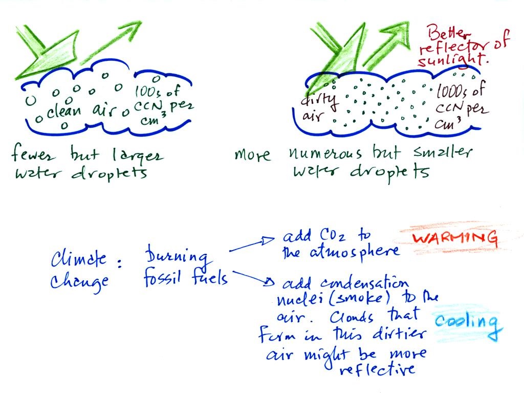
Clouds and climate change
This effect has some implications for climate change.
A cloud that forms in dirty
air is composed of a large number of small droplets (right
figure above). This cloud is more reflective than a cloud
that forms in clean air, that is composed of a smaller number of
larger droplets (left figure).
Combustion of fossil fuels adds carbon dioxide to the
atmosphere. There is concern that increasing carbon
dioxide concentrations (and other greenhouse gases) will enhance
the greenhouse effect and cause global warming. Combustion
also adds condensation nuclei to the atmosphere (just like the
burning match added smoke to the air in the flask). More
condensation nuclei might make it easier for clouds to form,
might make the clouds more reflective, and might cause
cooling. There is still quite a bit of uncertainty about
how clouds might change and how this might affect climate.
Remember that clouds are good absorbers of IR radiation and also
emit IR radiation.
Clouds are one of the best ways of cleaning the
atmosphere. This is something we mentioned earlier in the
semester and you're now in a position to understand it better.
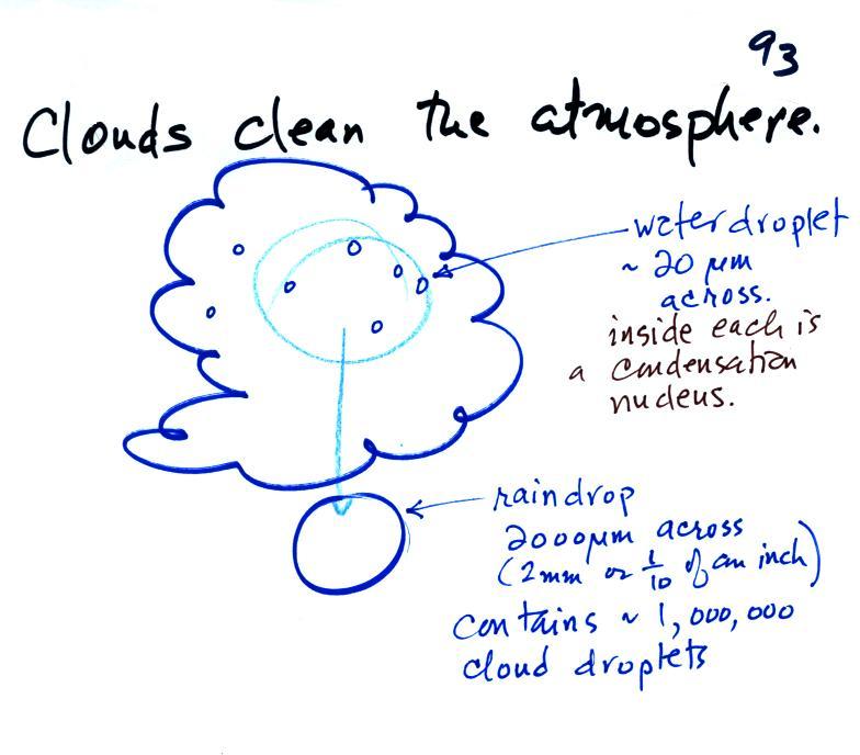
A cloud is composed of small water droplets (diameters of 10 or
20 micrometers) that form on particles ( diameters of perhaps
0.1 or 0.2 micrometers). The droplets "clump" together to form a
raindrop (diameters of 1000 or 2000 micrometers which is 1 or 2
millimeters), and the raindrop carries the particles to the
ground. A typical raindrop can contain 1 million cloud
droplets so a single raindrop can remove a lot of particles from
the air. You may have noticed how clear the air seems the
day after a rainstorm; distant mountains are crystal clear and
the sky has a deep blue color. Gaseous pollutants can
dissolve in the water droplets and be carried to the ground by
rainfall also. We'll be looking at the formation of
precipitation in more detail later this week.
Finally before we leave the topic of condensation nuclei,
here's Mother Nature's version of the cloud in a bottle
demonstration.

A
brush fire in this picture is heating up air and causing
it to rise. Combustion also adds some moisture and
lots of smoke particles to the air. You can see that
initially the rising air doesn't form a cloud (the RH is
still less than 100%). A little higher and once the
rising air has cooled enough (to the dew point) a cloud
does form. And notice the cloud's appearance - puffy
and not a layer cloud. Cumulo or cumulus is the word
used to describe a cloud with this appearance. These
kinds of fire caused clouds are called pyrocumulus
clouds. The example above is from a
Wikipedia article about these kinds of clouds.
The fire in this case was the
"Station Fire" burning near Los Angeles in August 2009.
We sometimes see clouds like this in the summer when lightning
starts a fire burning in one of the nearby forests. The
pyrocumulus cloud caused by the fire is sometimes the only
cloud in the sky.