Wednesday, Mar. 30, 2016
Music from the Fleet Foxes "Tiger
Mountain Peasant Song" (3:10), "Montezuma"
(3:39), "Lorelai"
(4:43), "Mykonos"
(4:35)
During the first portion of today's class we finished up the
material on identifying and naming clouds.
Then it seemed like a logical place to learn a little bit about
the 2 most common types of satellite photographs.
IR cloud photographs
When you see satellite photographs of clouds on the TV weather
report you are probably seeing infrared satellite photographs.
1. An infrared satellite photograph detects the 10
micrometer (μm) IR
radiation actually emitted by the ground, the ocean
and by clouds. You don't depend on seeing reflected
sunlight, so the earth can be photographed during the day and
at night. You may recall that 10 μm
radiation is in the middle of the atmospheric window, so this
type of radiation is able to pass through air without being
absorbed. If clouds don't get in the way, you can see
the ground on an IR photograph.
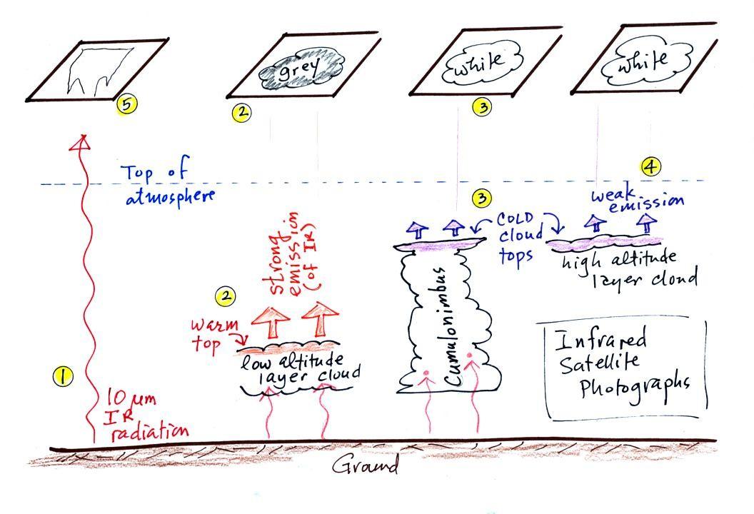
2. Clouds absorb 10 μm radiation
and then emit 10 μm IR
radiation of their own. The intensity of the cloud
radiation will depends on the cloud's temperature. The
top surface of a low altitude cloud will be relatively
warm. Warmer objects emit IR radiation at a greater rate
or at higher intensity (the Stefan Boltzmann law). This
is shown as grey on an IR satellite photograph. A
unimpressive grey looking cloud on an IR satellite photograph
may actually be a thick nimbostratus cloud that is producing a
lot of rain or snow.
3. Cloud tops found at high altitude are cold
and emit IR radiation at a lower rate or lower
intensity. This shows up white on an IR
photograph.
4. Two very different clouds (a thunderstorm
and a cirrostratus cloud) would both appear white on the
satellite photograph and would be difficult to
distinguish. Meteorologists are interested in locating
tall thunderstorms because they can produce severe weather.
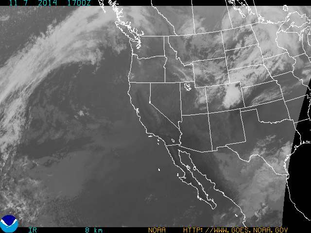
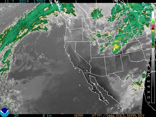
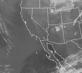
An example of an IR satellite photograph is shown
below. Slightly different shades of white or grey on IR
satellite photographs are difficult to distinguish with the
naked eye. The satellite sensor on the other hand is
able to precisely measure the intensity of the IR radiation it
is photographing. The images are often color enhanced to
bring out very small differences in intensity that are due,
ultimately, to differences in cloud temperature.
|
|
IR image
17 Z Nov. 7, 2014
|
color enhanced image
17 Z Nov. 7, 2014
|
The right image above is an enhanced version of the image
above at left (both images are from the National Oceanic and
Atmospheric Administration Geostationary
Satellite Server site). The intensity that
corresponds to a particular color can be determined using the
scale shown at the right edge of the image. For example
yellow appears to indicate an intensity of about 200 -
205. This corresponds to a temperature of about 215 K
(-58 C or -72 F)
4. Two very different clouds (a thunderstorm
and a cirrostratus cloud) would both appear white on the
satellite photograph and would be difficult to
distinguish. Meteorologists are interested in locating
tall thunderstorms because they can produce severe
weather. Fortunately, as we will see, these two cloud
types have very different appearances of visible satellite
photographs, so this ambiguity can be resolved.
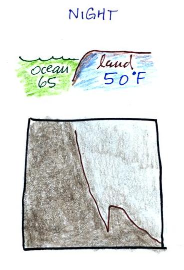
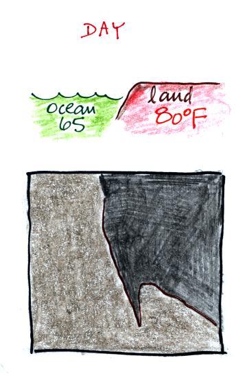
5. The ground changes temperature during
the course of the day. On an infrared satellite
animation you can watch the ground change from dark grey or
black (during the afternoon when the ground is warmest) to
lighter grey (early morning when the ground is cold) during
the course of a day. In the sketch below the ground
temperature varies between 80 F and 50 F during the day.
Because of water's high specific heat, the ocean right
alongside doesn't change temperature much during the day and
remains grey throughout the day. The ocean remains 65 F
throughout the day in the figure below.
|
|
Morning when
ground is cool
|
Afternoon when the
ground is warmer
|
|
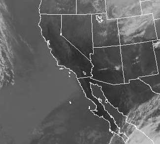
|
early morning (14 Z = 7 am
MST)
|
afternoon (21 Z = 2
pm MST)
|
Early morning (ground is cool) and afternoon (ground has
warmed) photographs are shown above. Zero in on the
center of the pictures (SW Arizona, S California, NW Mexico
and the northern end of Baja California). There don't
appear to be any clouds there so we are able to see the ground
and ocean. Note how much darker the ground appears in
the right (warm afternoon picture). I don't see a change
in the images of the ocean west of the California/Mexico
border in the two images
Here's a
link to an IR satellite photograph loop. It
is sometimes easier to see the changing appearance of the land
surface as it warms and cools when the pictures are in
motion.
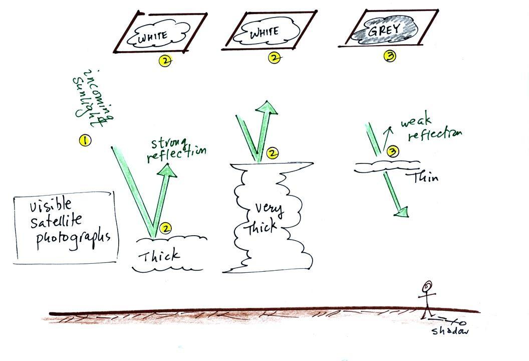
A visible satellite photograph
photographs sunlight that is reflected by clouds. You
won't see clouds on a visible satellite photograph at
night. Thick clouds are good reflectors and appear
white. Thinner clouds don't reflect as much light and
appear grey. The low altitude layer cloud and the
thunderstorm above would both appear white on this photograph
and would be difficult to distinguish.
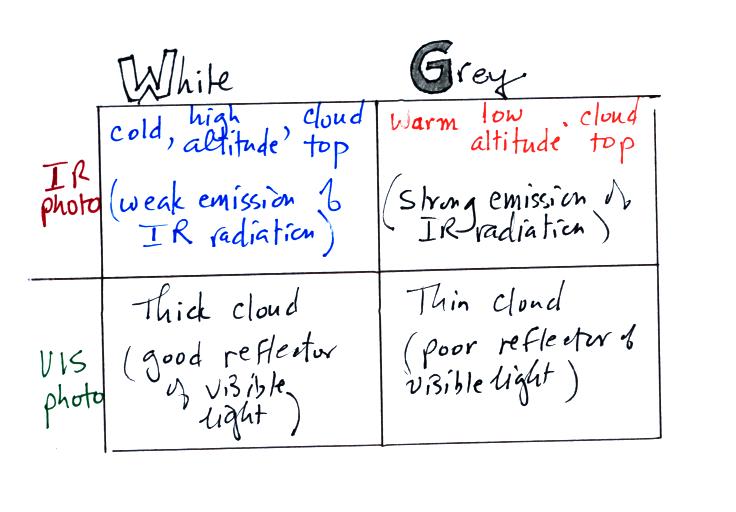
The table above summarizes what
we have learned so far.
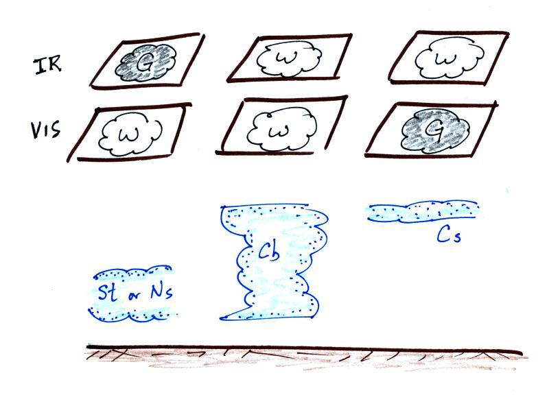
The figure below shows
how
if
you
combine
both
visible
and
IR
photographs
you
can
begin
to
distinguish
between different types of clouds.
Low stratus or nimbostratus clouds appear grey and white on
infrared and visible photographs, respectively.
Thunderstorms appear white on both types of satellite photographs.
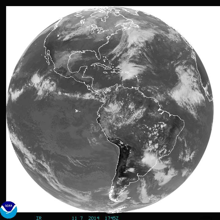
|
|
1745 Z (10:45 am MST) Full
Disk IR image
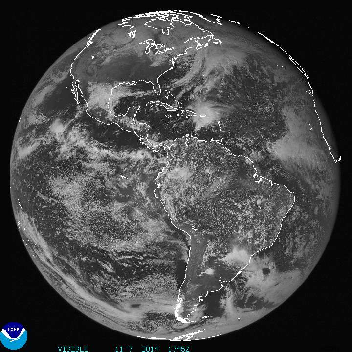
|
1745 Z Full Disk Visible image
|
A comparison of full disk INFRARED and VISIBLE images is shown
above. Perhaps the most obvious difference is the area of
clouds out over the Pacific Ocean and west of South America.
The clouds are bright white on the VIS image but barely
discernible on the IR image. These must be fairly thick low
altitude clouds, stratocumulus perhaps.
There's another even more striking difference between the two
images - the appearance of outer space. The earth appears on
a white background on the IR image. Remember that white on
an IR image indicates weak intensity IR emissions. In this
case the satellite is not detecting any IR emissions coming from
space - zero intensity IR radiation. The earth appears on a
black background in the VIS image. The satellite is not
seeing any visible light coming from space.
Geostationary orbit
The photographs above were taken from a satellite in
geostationary orbit. The satellite is positioned above the
equator at an altitude of about 22,000 miles altitude
(by comparison the International Space Station is about 260 miles
above the earth). At that altitude the satellite completes
one orbit a day. The motion of the satellite and the spin of
the earth are in the same direction. Thus the satellite
remains above and is always viewing the same point on the
ground.