Tuesday, Oct. 31, 2006
The Experiment #3 reports, the Scientific Paper reports, and the revised
Expt. #2 reports were all collected today. The Expt. #3 and the
Scientific Paper reports should be graded in about 1 week. The
revised reports may take a little longer.
Mid term grade summaries and more of the 1S1P reports were returned today
also. I also returned Optional Assignment #5 but forgot to
include Optional Assignment #4. I'll have that on Thursday.
A printed copy of the Quiz #3 Study Guide
was handed out in class. Quiz #3 is on Thursday this week.
Reviews will be held Tuesdayand Wednesday afternoons (see the study
guide
for times and locations)
We learned
about the collision coalescence and the ice crystal processes that
produce precipitation last Thursday.

Not too much in the way of variety from the
collision-coalescence process

Look at all the different types of precipitation particles
that the ice crystal process can produce. Not only can a variety
of types of precipitation particles be produced inside the cloud but
changes can occur once the particle falls from the cloud and travels to
the ground.
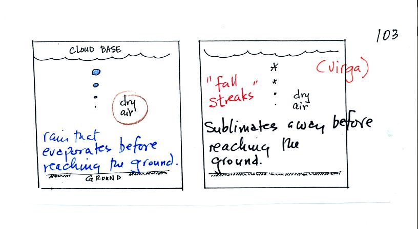
In the example above at left the particle first melts
(producing rain) and then
evaporates before reaching the ground. Rain that evaporates
before reaching the ground is called virga.
A similar thing can
happen with snow crystals or snow flakes. They sublimate away;
the streamers of falling precipitation are called fall streaks (I said
I would accept the name virga for this process also since it is the
same overall idea). You'll see white streamers falling from
cirrus clouds sometimes.
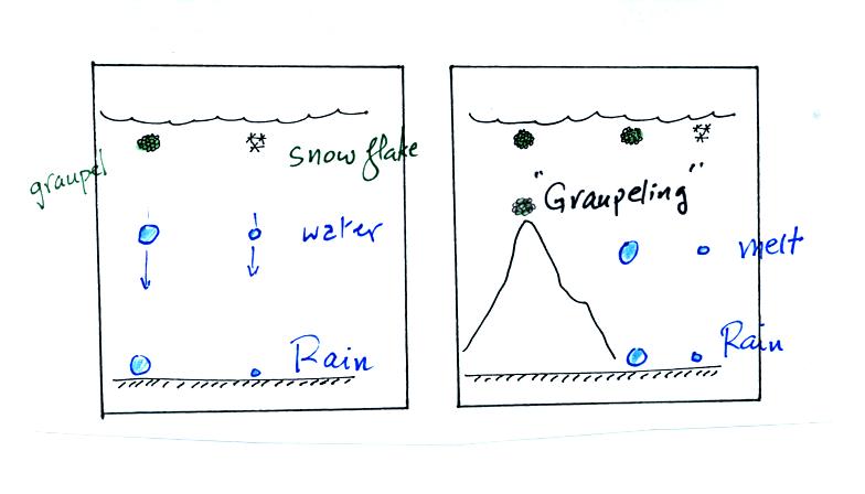
The frozen precipitation particles produced by the ice
crystal process
(graupel or snow) can melt before reaching the ground. This would
be rain (or drizzle if the drops are small). Rain in most
locations at most times of the year starts out as frozen precipitation
(even in Tucson in the summer).
If you are on a mountain top you might see some of the frozen
precipitation before it melts. You might see graupel falling from
a summer thunderstorm, for example, while the people in the valley only
observe rain.
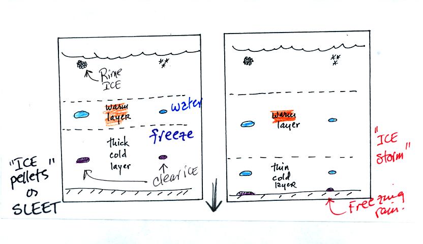
Sometimes the frozen precipitation will melt and then fall
into a thick
layer of cold air and refreeze. The resulting particle is called
sleet (or ice pellets). The clear ice in sleet is noticeably
different from the frosty, milky white, rime ice in graupel.
Rain that falls into a shallow cold air layer and freezes after
reaching the ground is called freezing rain. It is nearly
impossible to drive during one of these "ice storms." Sometimes
the coating of ice is heavy enough that power lines are brought down
and branches on trees are broken. It sometimes takes several days
for power to be restored because utility vehicles can't drive on the
ice covered roads.
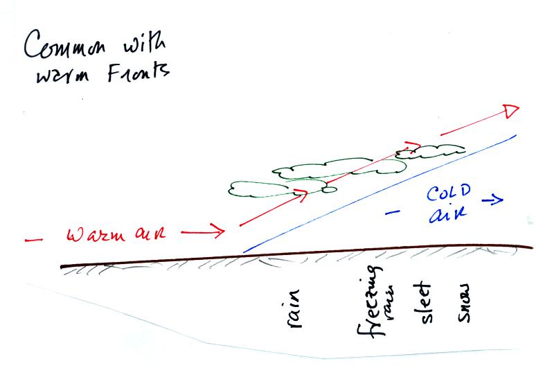
A common place to see such a variety of types of precipitation is with
passage of a warm front. The normal sequence is shown above
starting with snow well out ahead of the surface front and ending with
rain near the surface front. Notice how the thickness of the cold
air layer determines whether sleet or freezing rain occurs.
Satellite
photographs are a good way of observing clouds
(especially out over the ocean). By using both visible and
infrared light satellite photographs you can get a good idea of cloud
type (as we will see later in today's class). However satellite
photographs don't really tell you whether a cloud is producing
precipitation or not.
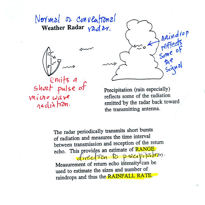
An ordinary radar periodically transmits a short burst of
microwave
radiation. This radiation penetrates a cloud but is reflected by
precipitation particles. The radar keeps track of what direction
the antenna is pointing and determines how long it takes for a signal
to go out and return. The radar also measures the strength of the
return signal. Conventional radar can thus locate the
precipitation and provide an estimate of its intensity.

The radar antenna slowly spins as it is transmitting so it
scans a full
360 degrees in a minute or two.
Information from a single radar or a combination of data from many
radars are drawn on weather maps (the PPI display above shows the data
from a single radar, the radar would be at the center of the
picture). This would show where precipitation is occurring.
The radar data is often combined with satellite photographs.
Colors are used to indicate the intensity of the precipitation.
Yellows, oranges and reds generally indicate the heaviest precipitation
(often coming from thunderstorms).
In research the radar can be used to scan vertically through a storm,
this produces an RHI display.
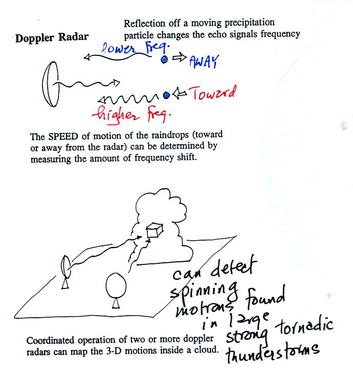
By detecting changes in the frequency of the reflected
signal, a
doppler radar can measure the speed at which precipitation particles
are moving toward or away from a radar antenna. By combining data
from 2 or more radars (and some complicated computer processing),
three-dimensional wind motions inside a cloud can be mapped out.
Doppler radars can detect a rotating thunderstorm updraft (a
mesocyclone) that could indicate a thunderstorm capable of producing
tornadoes. Small mobile doppler radars are being used to try to
measure wind speeds in tornadoes. Police use doppler radar to
measure the speeds of automobiles on the highway.
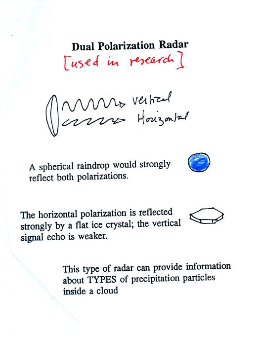
Radar can also be used to learn something about the kinds of
precipitation particles inside a cloud.
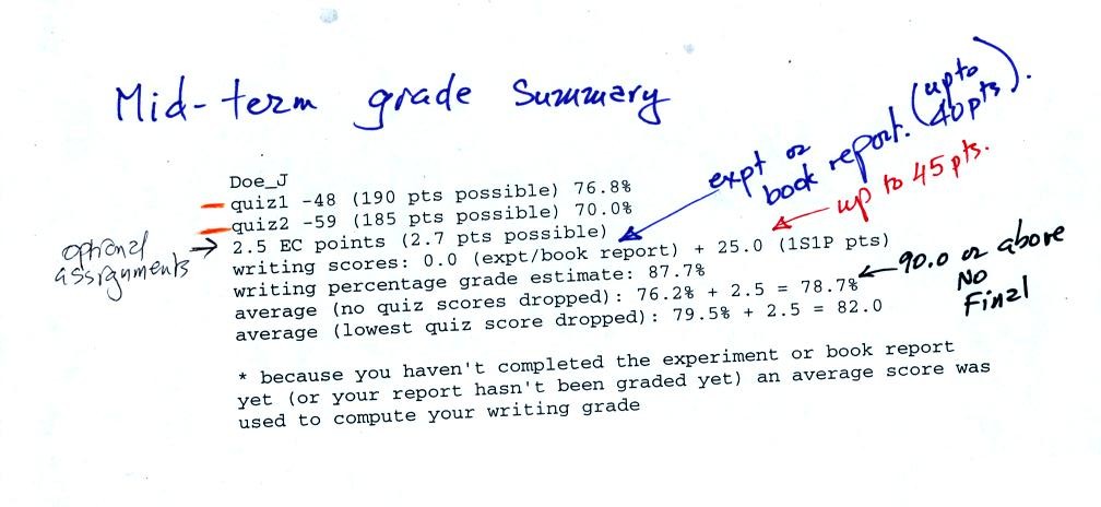
As mentioned above, grade summaries were distributed in
class.
You should first check to see that quiz grades have been recorded
correctly and that you have been given credit for the optional
assignments, 1S1P reports (not all of the Assignment #2 reports have been
graded), and experiment/book reports that you have turned in.
The computer has also tried to predict what grade you will end up with
at the end of the semester if you keep performing as you have been so
far this semester (it uses an average report grade if you haven't yet
turned in an experiment report or your report hasn't been graded
yet). There is a little "guesswork" involved here, these really
are grade estimates. Your grade can improve or could get worse
between now and the end of the semester.
We
finished up with some new material on Newton's Laws of Motion in
Chapter 6 that we will be covering after the next quiz. This material
will not be covered on Quiz #3 and will
be moved to the Tuesday Nov. 7 notes.