Monday Nov. 9, 2009
click here to download today's notes in
a more printer friendly format
Well it's Friday and I am finally able to work on Monday's online notes.
Music (if I remember correctly) was from Gaelic Storm
We first
looked at a short explanation of the cause of the Coriolis force.
This material can be found in the Friday Nov. 6
online notes.
It seemed appropriate at this point to look at a
common misconception involving the Coriolis force. You
might
already have heard that water spins in a different direction
when it drains from a sink or a toilet bowl in the southern hemisphere
than it does in the northern hemisphere. You might also have
heard that this is due to the Coriolis force or the Coriolis
effect.
The Coriolis force does
cause winds to spin in opposite directions around high and low pressure
centers in the northern and southern hemisphere. The
PGF starts the air moving (in toward low, out and
away from high pressure) then the Coriolis force bends the wind to the
right (N. hemisphere) or to the left (S. hemisphere).
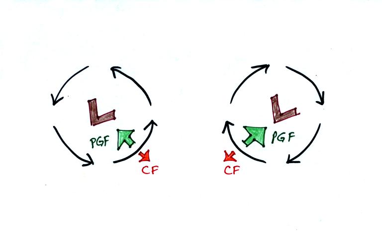
Here's what you end up with in the case of low pressure:
Wind motions around an upper level low. The
example at left would be found in the northern (the CF is pointing to
the right of the wind)? The PGF is stronger than the CF. This
results in a new inward force, something that is needed for wind to
blow in a circular path.
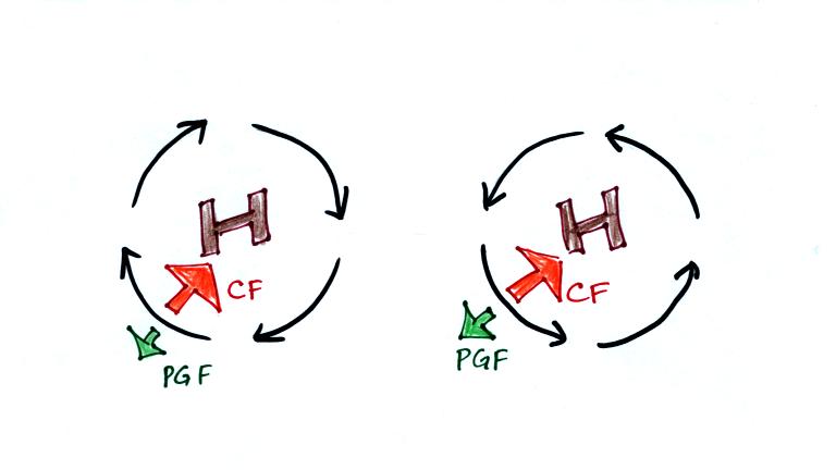
Winds also spin around high
pressure. The CF is absolutely essential in this case. The
CF is stronger than the PGF and the CF points
inward. The CF is what provides the needed inward force needed to
keep the winds blowing in a circular path.
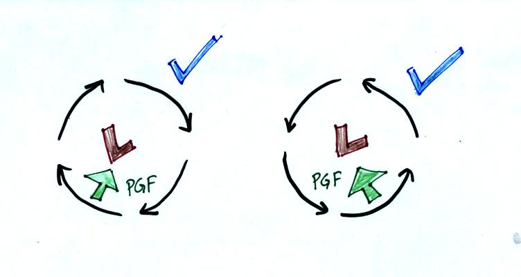
There are situations where the PGF is much stronger than the CF; the CF
can be ignored.
Winds can still spin around LOW. The
PGF supplies the
necessary net inward force.
This is the case with
tornadoes, for example. Tornado winds spin around a core of very
low pressure.
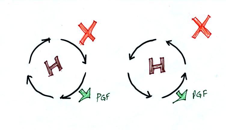
Winds can't blow around high pressure without the
CF. The PGF points ouward with high
pressure. Without the CF,
there isn't any inward force.
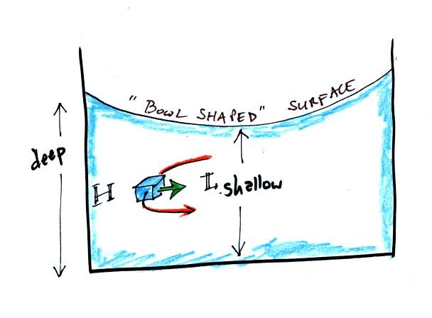
When water spins and drains from a sink or a toilet,
the water is a little deeper on the outside than on the inside.
This creates an inward pointing pressure difference force. There
needs to be an inward force in order for the water to spin. Water
can spin clockwise or counterclockwise when draining from a sink in the
northern hemisphere. It can spin in either direction in the
southern hemisphere also.
Now we watched a short video segment that seemed to show
otherwise. Don't believe everything you see on video. The
gentleman in the video was just very good at getting the draining water
to spin one direction or another as he moved on opposite sides of the
equator. Probably the most difficult part would be to get the
water draining without spinning, which is what he was able to do when
standing right on the equator.
Would you like to earn 0.1 pts
(maybe 0.2 pts) of
extra credit? If so click here.
Next we finished up some material on surface winds. That
also can be found near the end of the Friday Nov.
6 online notes.
The
last topic covered today was thermal circulations. The notes
below are a little bit more detailed than was covered in class.
Differences
in temperature like you might find between a coast and
the ocean or between a city and the surrounding country side can create
horizontal pressure differences. The horizontal pressure gradient can
then produce a wind flow pattern known as a thermal circulation.
These are generally relatively small scale circulations and the
pressure gradient is so much stronger than the Coriolis force that the
Coriolis force can be ignored. We will learn how thermal
circulations develop and then apply to concept to the earth as a
whole
in order to understand large global scale pressure and wind
patterns. You'll find this
discussed on p. 131 in the photocopied Class Notes.
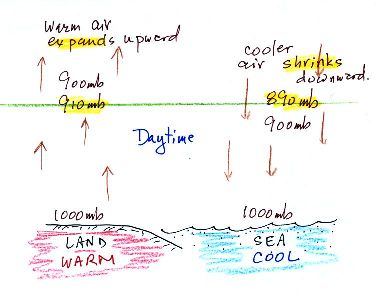
We'll start here along a sea
coast. In this picture the air temperatures and pressures (at the
ground and aloft) are the same over the land and over the ocean.
A beach will often become much warmer than the
nearby
ocean during
the day (the sand gets hot enough that it is painful to walk across in
barefeet). The warm air over the land will expand upward.
Note how the 900 mb level moves above the level of the green line in
the picture. The cooler air over the ocean will shrink and move
downward. The 900 mb level drops below the level of the green
line.
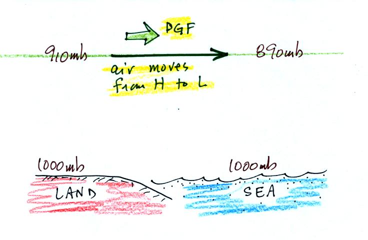
The temperature differences have created an upper level pressure
gradient (pressure difference), higher pressure (910 mb) on the left
and lower pressure (890 mb) on the right. The pressure difference
force causes air to start to blow from left to right.
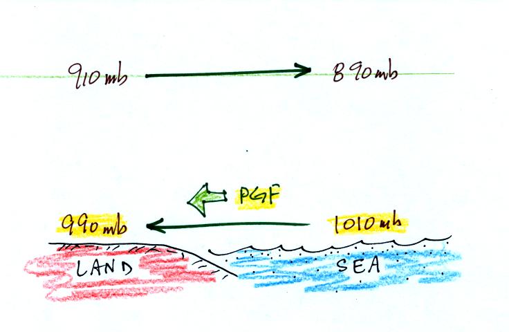
Once the air aloft begins to move it will change the surface
pressure pattern. Air aloft leaving the left side of the picture
will lower the surface pressure (from 1000 mb to 990 mb). Adding
air aloft to the right side of the picture will increase the surface
pressure (from 1000 mb to 1010 mb). Surface winds will begin to
blow from right to left.
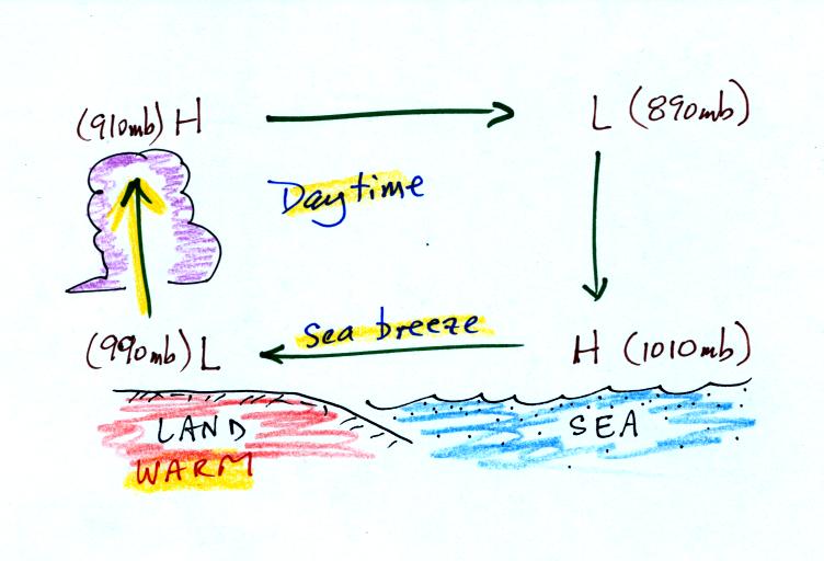
You can complete the circulation loop by adding rising air
above the
surface low pressure at left and sinking air above the surface high at
right. The surface winds which blow from the ocean onto land are
called a sea breeze (the name tells you where the winds come
from). Since this air is likely to be moist, cloud formation is
likely when the air rises over the warm ground (I'm not sure why I
colored the cloud purple in this picture).
It is pretty easy to figure the directions of the winds in a thermal
circulation without going through a long-winded development like
this. Just remember that warm air rises. Draw in a rising
air arrow above the warm part of the picture, then complete the loop.
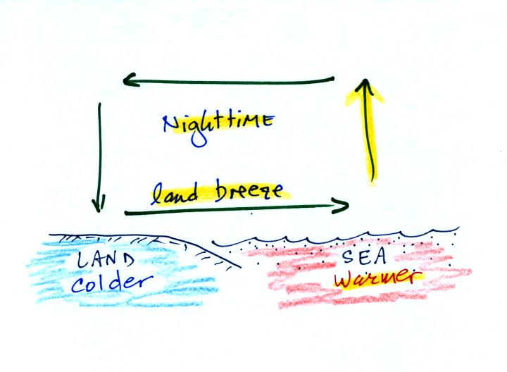
At night the ground cools more quickly than the ocean and becomes
colder than the water. Rising air is found over the warmer ocean
water (sea below). The thermal circulation pattern reverses
direction. Surface winds blow from the land out over the
ocean. This is referred to as a land breeze.