Tuesday Nov. 8, 2011
click here to
download today's notes in a more printer friendly format
Music
before
class
today was Caravan
performed at the Django Reinhardt
New York Jazz Festival in 2004
Photos
of
the
All
Souls
Procession
from the Arizona Daily Star
Quiz #3 has been graded and was returned in class. The
average was a little low but that seems to be a normal occurrence for
the 3rd quiz of the semester. Quiz scores from the some past
classes and the MWF class are compared below.
|
Fall 2010
|
Spring 2011
|
Fall 2011(MWF)
|
Fall 2011 (T Th)
|
Quiz #1
|
78%
|
80%
|
78%
|
73%
|
Quiz #2
|
74%
|
75%
|
74%
|
75%
|
Quiz #3
|
76%
|
71%
|
71%
|
69%
|
Quiz #4
|
79%
|
80%
|
? |
? |
One way to boost your overall grade is to earn a high writing
grade. Your writing grade should be near 100%. The writing
grade is made up of your Experiment report score and the points you
earn on the 1S1P Assignments. Speaking of which there is a new 1S1P Bonus Assignment
(actually 2 Bonus Assignments by the time I got around to putting
today's notes online) now available (due on or before Thu., Nov. 17)
In the
next couple of classes we will be looking at how
and why
surface and upper level
winds blow the way they do.
Some real world examples of where
this occurs are shown in the figure
below (found on p. 121 in the ClassNotes). The two largest types
of storm systems, middle latitude
storms (extratropical cyclones) and hurricanes (tropical cyclones),
develop around surface centers of low
pressure. Winds
spin counterclockwise around cyclones (centers of low pressure) in the
northern hemisphere and
clockwise in the southern hemisphere.
Winds spin clockwise around
"anticyclones" (high pressure) in the northern hemisphere and
counterclockwise in the southern hemisphere.
Why do winds blow in opposite directions around high and low
pressure. Why do the winds change directions when you move from
the northern to the southern hemisphere. These are the kinds of
questions we'll be addressing.
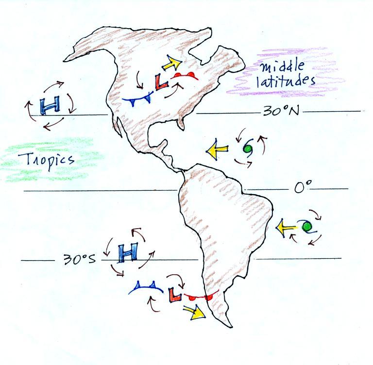
Storm systems in the tropics (0 to
30 degrees latitude) generally move
from east to west in both hemispheres. At
middle latitudes (30 to 60 degrees), storms move in the other
direction,
from west to
east. To understand why this is true we need to learn something
about the earth's global scale pressure and wind patterns. This
is a topic we will be getting into later this week.
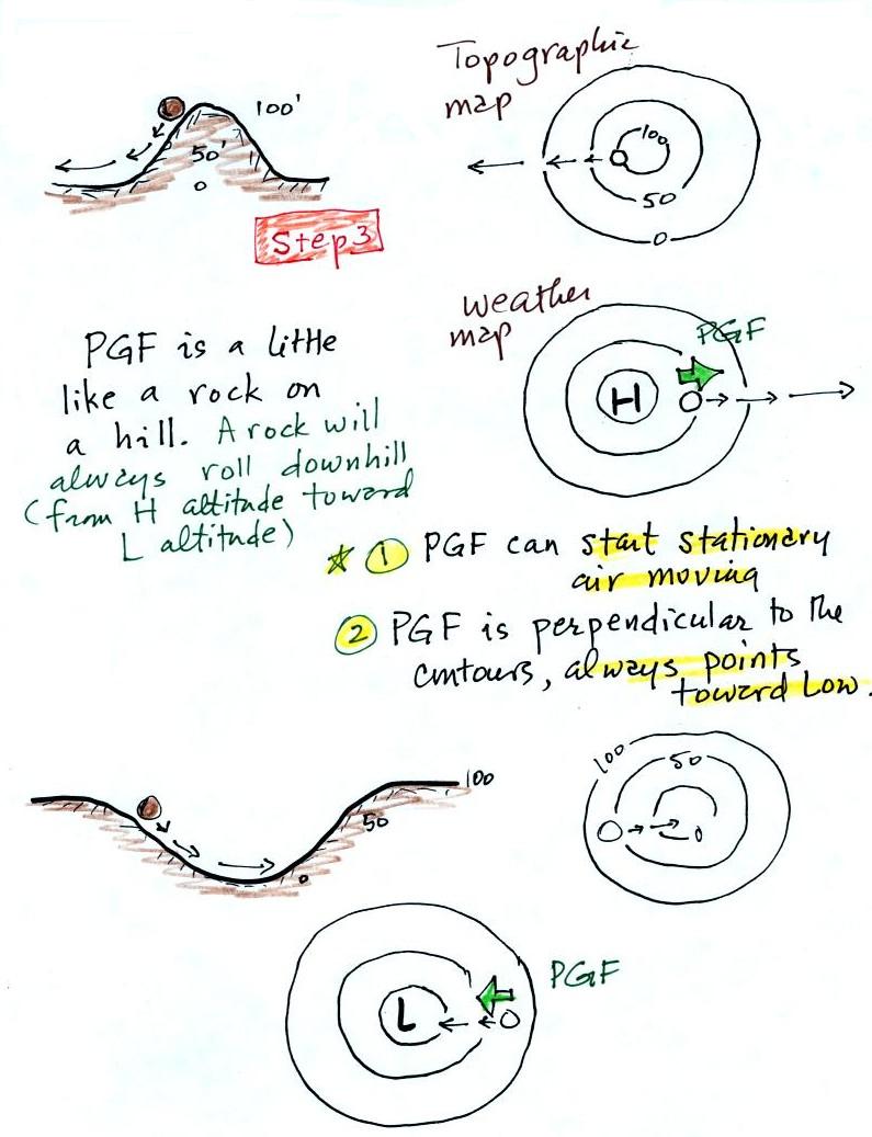
I've borrowed some more carefully
drawn figures below from the
Spring 2009
online notes. Step #1 is found on p. 122a in the
ClassNotes.

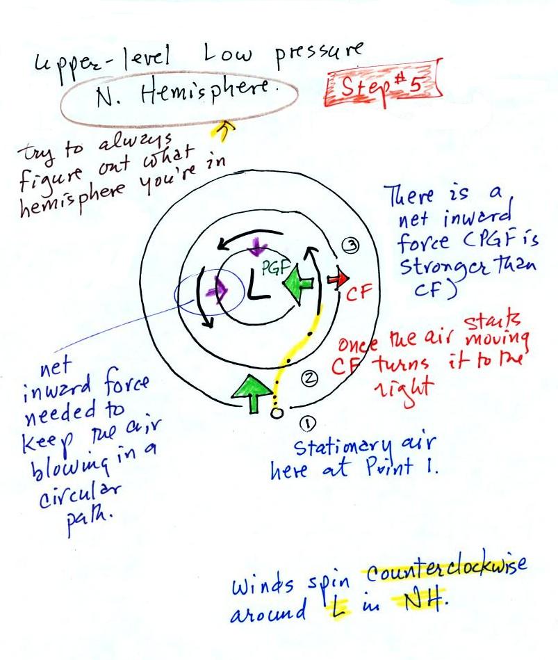
Upper level winds spinning around
high and low pressure in the
northern and southern hemispheres are shown in the first set of four
pictures. The first thing to notice is that upper level winds
blow parallel to the contours. We will see that 2 forces, the
pressure gradient force (PGF) and the Coriolis force (CF), cause the
winds to blow this way. Eventually you will be able to
draw the directions of the forces for each of the four upper level
winds examples. Here is an
example
of what you will be able to do.
The four drawings at the bottom of the page show surface winds
blowing
around high and low pressure in the southern hemisphere. These
winds blow across the contour lines slightly, always toward low
pressure. The frictional force is what causes this to
occur. He is
an example of what you will be able to say about surface winds
blowing around low pressure in the southern hemisphere.
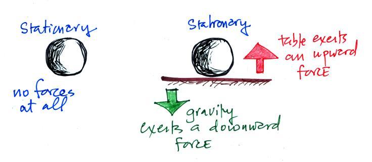
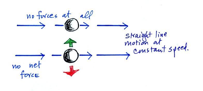
You should be able to look at an
object's (or the wind's) motion and tell if there is a net force or
not. The only time there is no net force is when the object is
stationary or moving in a straight line at constant speed (both
conditions must be met).
There aren't any forces at all acting on the object above at
left. There are forces at right but they cancel each other out
and the net force is zero. The objects below will continue to
move in a straight line at constant speed. The pictures above
and below weren't shown in class.
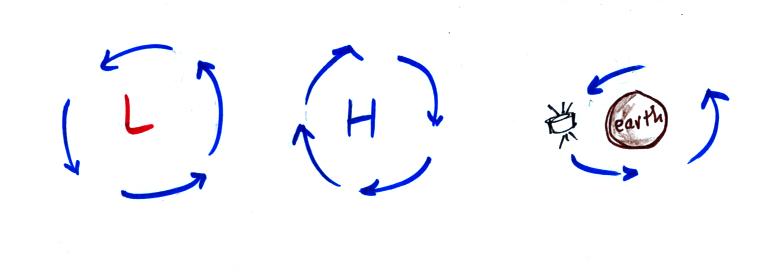
Another important point to take from Step #2
is that a net inward force is
needed anytime an object is moving in a circular path even if the speed
is constant. It doesn't
matter what direction the object is moving and it doesn't matter what
the object is circling around. Here are a few more examples. This figure wasn't shown in class.
A net inward force is needed to keep winds spinning around a
center of low pressure, an inward force is needed to keep air moving in
a circular path around high pressure, and a net inward force (gravity)
is needed to keep a satellite in a circular orbit around the earth.
Quite a few people would say there is an outward force being
exerted in
the bottom picturebelow, but the force is inward in each of the cases.
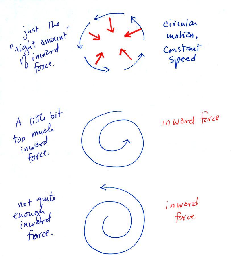
It's just not the same amount of
inward force. The amount of
force is just right in the top figure, a little "too strong" in the
middle figure, and "not quite strong enough" in the bottom figure.
Now we'll
start to look at the forces that cause the wind to blow.
Air moving inward toward low
pressure or outward away from high pressure is similar to a rock
rolling down and away from the summit of a hill or inward toward the
bottom of a depression. The pressure gradient force always
points perpendicular to the contour lines on a map and toward low
pressure.
The PGF will cause stationary air to begin to move (it will always move
toward low
pressure).
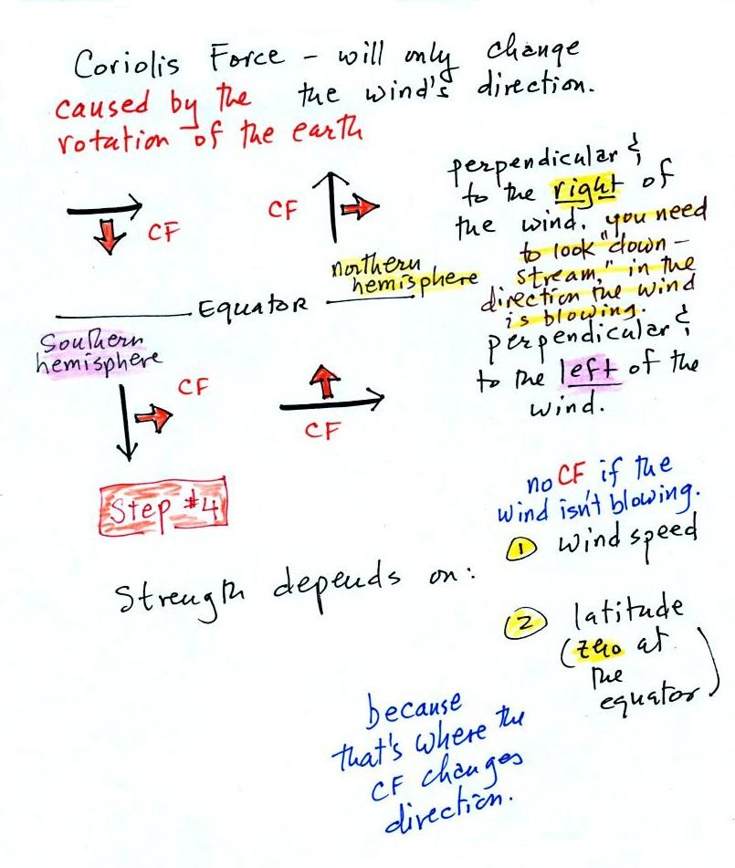
The Coriolis force is caused by the
rotation of the earth. We'll learn more about what causes the
Coriolis force on Wednesday. The CF points
perpendicular to the wind and can only
change the wind's direction. It can't cause the wind to speed up
or
slow down. The direction of the CF depends on whether you're in
the northern or southern hemisphere.
Time now to begin applying what we've learned.
We start with some stationary air at Point 1. The PGF at Point 1
starts stationary air moving toward the center of low pressure (just
like a rock would start to roll downhill).
Once the air starts to move, the CF causes it to turn to the right
(because this is a northern hemisphere chart). The wind
eventually ends up blowing parallel to the contour lines and spinning
in a
counterclockwise direction. Note that the inward PGF is stronger
than the outward CF. This results in a net inward force,
something that is needed anytime wind blows in a circular path.
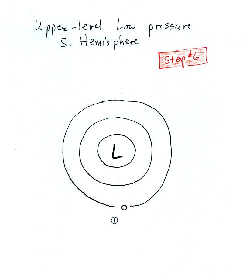
We start again with some stationary air at Point 1 in this
figure. See if you can figure out will happen next. When
you
think you have the answer click here.
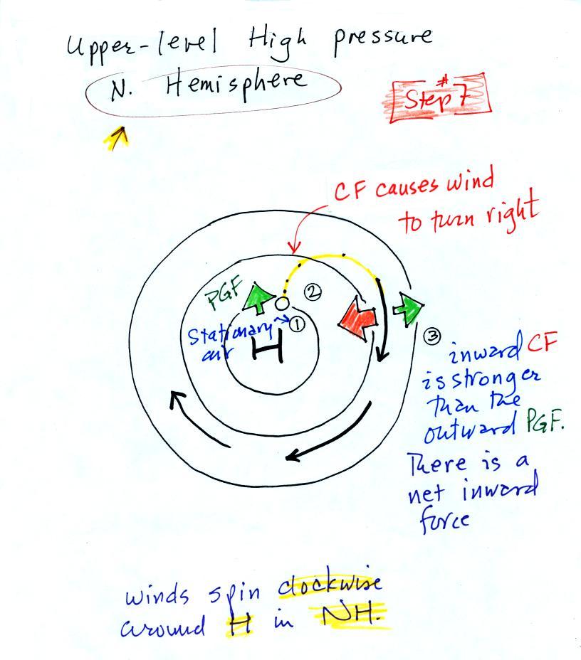
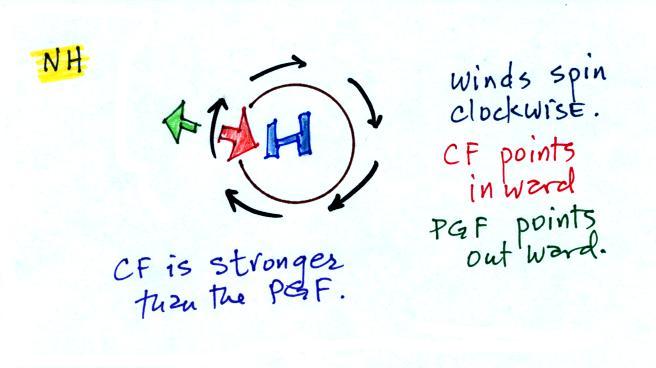
With high pressure the air starts
moving outward. In this
example
the wind takes a right turn and ends up blowing in a clockwise
direction around the high. Note there is a net inward force here
just as there was with the two previous examples involving low pressure.

Try this one on your own.
When you think you have the
answer, click here.
2 steps left. Upper level winds blow parallel to the contour
lines. Now we'll see how/why friction causes surface winds to
blow across the contour lines (always toward low pressure).

We add friction in the second picture. It points in a direction
opposite the wind and can only slow the wind down. The strength
of the frictional force depends on wind speed (no frictional force if
the wind is calm) and the type of surface the wind is blowing over
(less
friction when wind blows over the ocean, more frictional force when the
wind is blowing over land).
Slowing the wind weakens the CF and it can no longer balance the
PGF (3rd figure). The stronger PGF causes the wind to turn and
start to blow across the
contours toward Low. This is shown in the 4th figure.
Eventually the CF and Frictional force, working together, can balance
out the PGF.
What we've learned from the straight contour example, namely
that
the winds will blow across the contours toward low pressure can be
applied to a curved contour pattern. The figure below
wasn't shown in class.
If you take a small little piece of
a curved pattern and magnify it, it will look straight. This is
shown above.
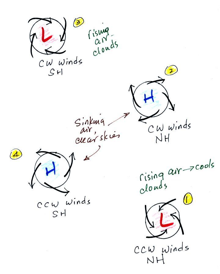
Here is Step #10. It is easy to figure out which of
the figures are centers of
low pressure. The winds are spiralling inward in the top and
bottom
examples (1 and 3).
These must be surface centers of low pressure. The winds are
spiraling outward from the centers of high pressure (2 and 4).
Now you probably don't want to figure out which of these are northern
and which are southern hemisphere pictures. It is probably best
to remember one of the pictures. Remember in 1, for example, that
surface winds spin
counterclockwise and spiral inward around centers of
low pressure in the northern hemisphere (something we learned
early in
the semester). Then remember that winds spin in the other
direction and blow outward around high pressure in the northern
hemisphere (2). The spinning directions of the winds reverse when
you move from the northern to the southern hemisphere. Thus you
find clockwise spinning winds and inward motion around low pressure (3)
and counterclockwise and outward spiraling winds around high pressure
in the southern hemisphere.
Converging winds cause air to
rise. Rising air expands and cools and can cause clouds to
form. Clouds and stormy weather are associated with surface low
pressure in both hemispheres. Diverging winds
created sinking wind motions and result in clear skies.