Monday Mar. 26, 2007
The Experiment #3 reports were collected
today. It generally takes about one week to grade these reports.
The Experiment #2 revised reports have been graded and were returned in
class.
The Optional Assignment on humidity was collected in class.
We'll
learn how clouds are identified and classified in today's class.
The ten main cloud types are listed below (you'll find this list on p.
95 in the photocopied class notes).
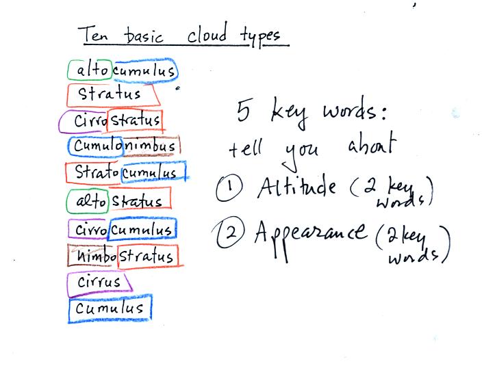
You will notice that the 10 cloud names are all built up
using 5 "key
words" (alto, cumulo or cumulus, strato or stratus, cirro or cirrus,
and nimbo or nimbus). The best way to learn these cloud names and the
characteristics of each cloud type is to learn the 5 key words.
Clouds are classified according to the altitude at which they form and
the appearance of the cloud. There are two key words for altitude
and two key words for appearance.
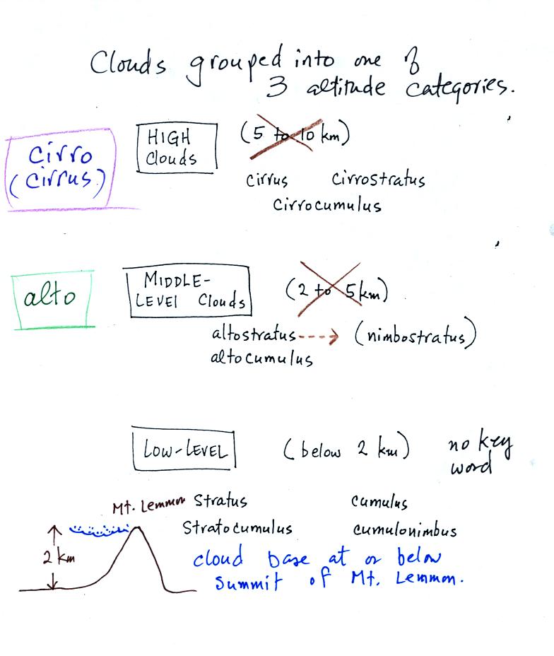
Cirrus or cirro
identifies a high altitude cloud. Alto in a cloud name means the
cloud is found at middle altitude. It is very hard to just look
up in the sky and determine a cloud's altitude. You will need to
look for other clues to distinquish between high and middle altitude
clouds. We'll learn about some of the clues you can look for in
class.
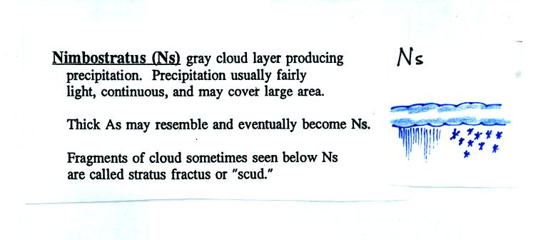
The dotted line connecting altostratus and nimbostratus indicates that
they are very similar. When an altostratus cloud begins to
produce rain or snow its name is changed to nimbostratus. A
nimbostratus cloud is often somewhat thicker and lower than an
altostratus cloud.
There is no key word for low altitude clouds. Low
altitude clouds
have bases that form 2 km or less above the ground. The summit of
Mt. Lemmon in the Santa Catalina mountains north of Tucson is about 2
km above the valley floor. So low altitude clouds will have bases
that form at or below the summit of Mt. Lemmon.
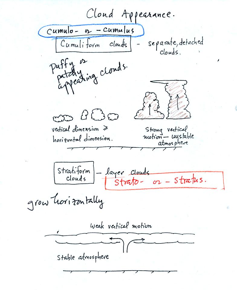
Clouds can have a patchy of puffy (or lumpy or wavy)
appearance.
These are cumuliform clouds and will have cumulo or cumulus in their
name. In an unstable atmosphere cumuliform clouds will grow
vertically.
Stratiform clouds grow horizontally and form layers. They form
when the atmosphere is stable.

Nimbo or nimbus in a cloud name means the cloud is or is
capable
of
producing significant precipitation. Note that only 2 out of the
10 cloud types is capable of producing appreciable amounts of
precipitation. Nimbostratus clouds tend to produce fairly light
precipitation over a large area. Cumulonimbus clouds produce
heavy showers over localized areas. Thunderstorm clouds can also
produce hail. Hail would never fall from a Ns cloud.
While you are still learning the cloud names you might put the correct
key words together in the wrong order (stratonimbus instead of
nimbostratus or nimbocumulus instead of cumulonimbus). You won't
be penalized for those kinds of errors in this class.
Next we
looked at photographs of most of the 10 main cloud types. You'll
find the written descriptions of the cloud types on pps 97-98 in the
photocopied notes. Some
additional details and sketches have been added below that weren't
covered in class.
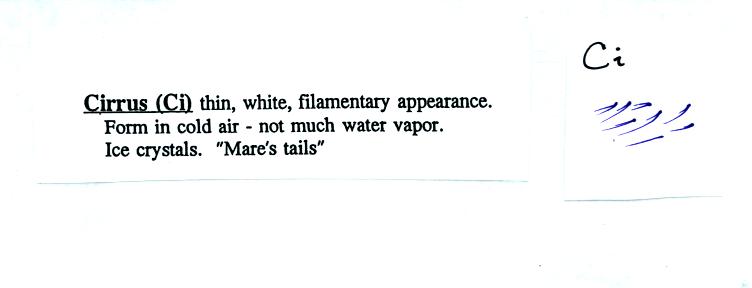
High altitude clouds are thin because the air at high
altitudes is
very cold and cold air can't contain much moisture (the saturation
mixing ratio for cold air is very small). These clouds are also
often blown around by fast high altitude winds. Filamentary means
"stringy" or streaky. If you imagine trying
to paint a Ci cloud you would dip a stiff
brush in white paint brush it quickly and lightly across a blue colored
canvas.
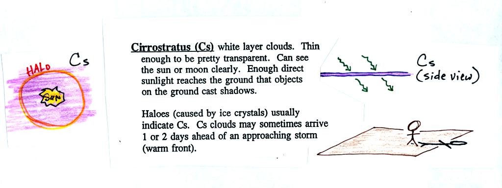
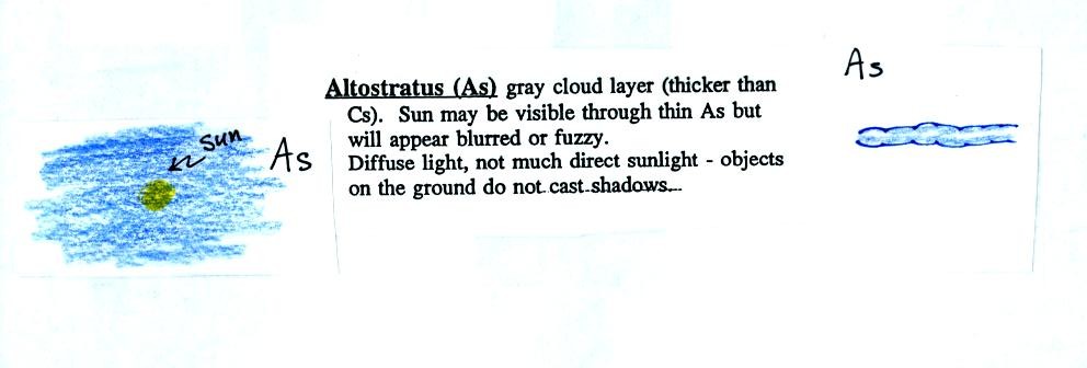
A cirrostratus cloud is a thin uniform white layer
cloud
(not purple as shown in the figure) covering
part or all of the sky. Here you might first dilute your white
paint with water and then
brush back and forth across the canvas. The thin white paint
might not be thick enough to hide the blue canvas but the white coating
on the canvas would be uniform not streaky like with a cirrus cloud.
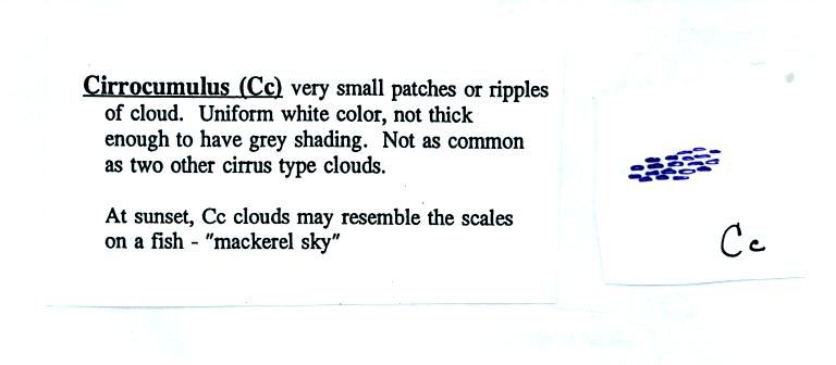
To paint a Cc cloud you would dip a sponge in white paint
and
press it gently against the canvas. You would leave a patchy,
splotchy
appearing cloud (sometimes you might see small ripples). It is
the patchy (or wavy) appearance that makes
it a cumuliform cloud.
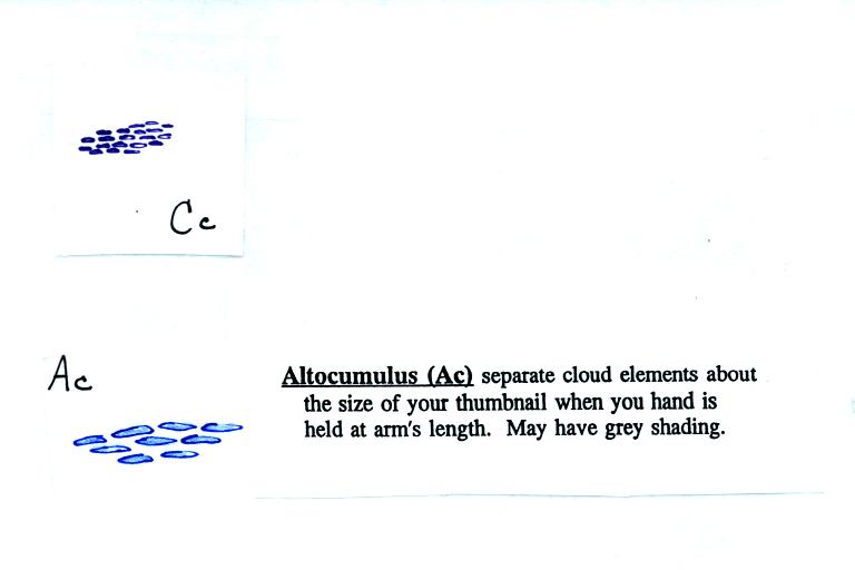
Note since it is hard to accurately judge altitude, you must
rely
on cloud element size to determine whether a cloud belongs in the high
or middle altitude category. The cloud elements in Ac clouds
appear larger than in Cc because the cloud is closer to the ground.
Lenticular clouds (see Fig. 4.31 on p. 105 in the text) are a special
type of altocumulus cloud.
When (if) an
altostratus cloud begins to produce precipitation, its name is changed
to nimbostratus.
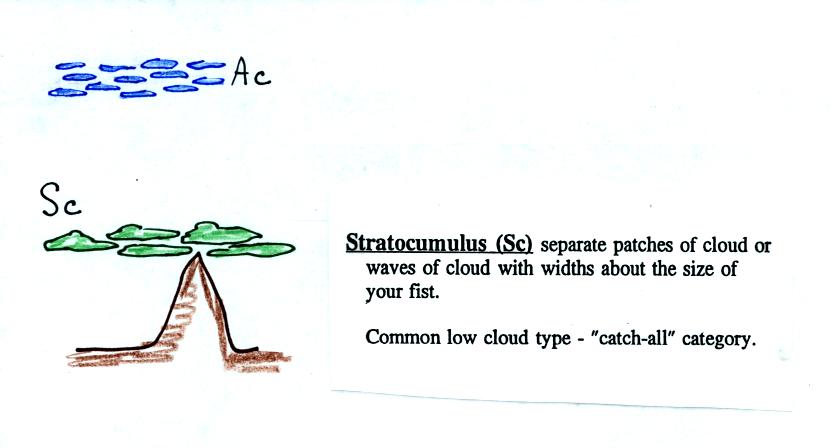
This cloud name is a little unusual because the two key
words for cloud
appearance have been combined. Because they are closer to the
ground, the separate patches of Sc are about fist size. The
patches of Ac, remember, were about thumb nail size.
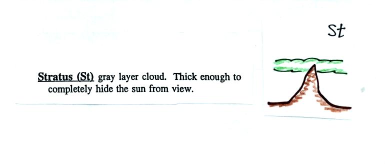
There weren't any examples of stratus clouds in the slide
collection.
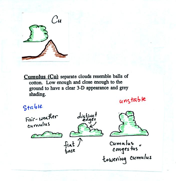
Cumulus clouds come with different degrees of vertical
development. The fair weather cumulus clouds don't grow much
vertically at all. A cumulus congestus cloud is an intermediate
stage between fair weather cumulus and a thunderstorm.
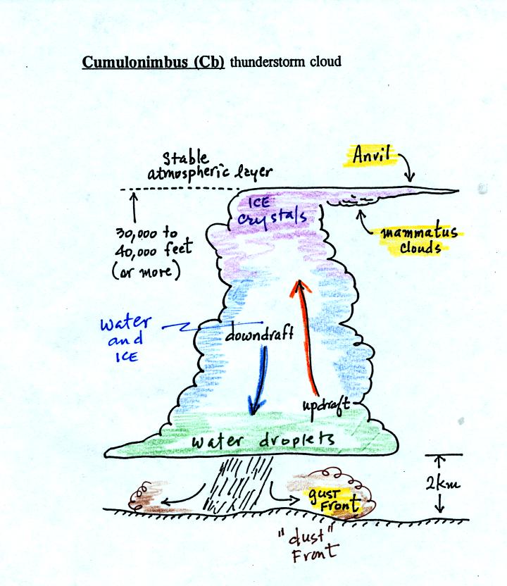
There are lots of distinctive features on cumulonimbus
clouds including the flat anvil top and the lumpy mammatus clouds
sometimes found on the underside of the anvil. Cold dense
downdraft winds hit the ground below a thunderstorm and spread out
horizontally underneath the cloud. The leading edge of these
winds produces a gust front. Winds at the ground below a
thunderstorm can exceed 100 MPH, stronger than many tornadoes.
The top of a thunderstorm is cold enough that it will be composed of
just ice crystals. The bottom is composed of water
droplets. In the middle of the cloud both water
droplets and ice crystals exist together at temperatures below freezing
(the water droplets have a hard time freezing). Water and ice can
also be found together in nimbostratus clouds. We will see that
this mixed phase region of the cloud is important for precipitation
formation. It is also where the electricity that produces
lightning is generated.
Here's one final feature to look for at the bottom of a
thunderstorm.
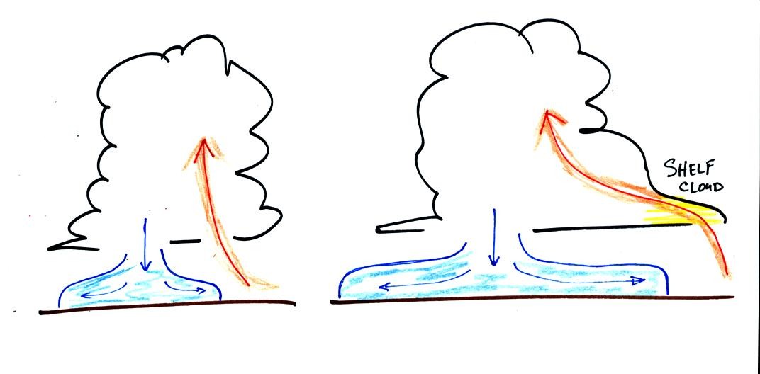
Cold air spilling out of the base of a thunderstorm is just
beginning
to move outward from the bottom center of the storm in the picture at
left. In the picture at right the cold air has moved further
outward and has begun to get in the way of the updraft. The
updraft is forced to rise earlier and a little ways away from the
center of the thunderstorm. Note how this rising air has formed
an extra lip of cloud. This is called a shelf cloud. You'll
find a good photograph of a shelf cloud in Fig. 10.7 in the text.
Here's a
good way to learn the 10 basic cloud type names. Draw a table
like the one shown below.
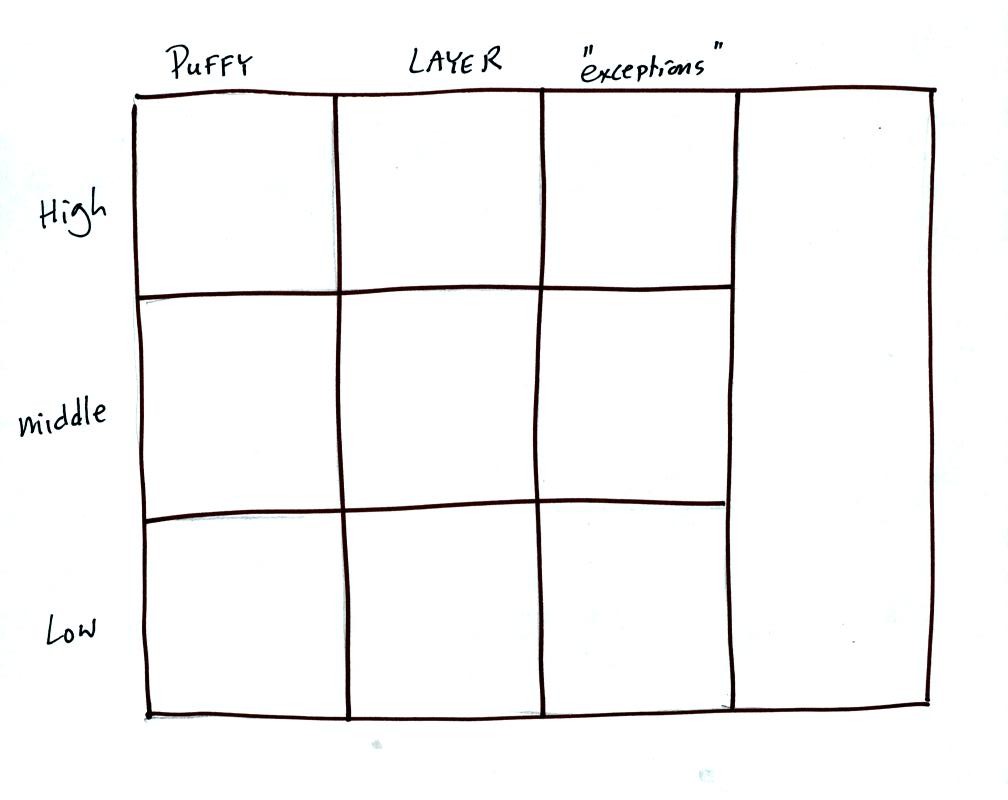
Then fill in each square with an appropriate cloud name and
a
sketch of the cloud. You should also be able to describe each
cloud type in words.
Click here to see a finished
chart.