Friday, Apr. 19, 2019

Blind Boys of Alabama "Amazing Grace" (6:15), "I Shall Not Be Moved" (4:15), "If I Had a Hammer" (5:02)
Patty Griffin "Shine a Different Way" (5:17), "Top of the World" (4:24), "Waiting for My Child" (4:20), "Move Up" (2:43)


We'll be using page 141, page 142, page 143, and page 144 as we cover hurricanes today and probably next Monday.

We'll finish up the small section on "upper atmospheric lightning" before starting on the material below

Hurricanes


This is the last topic we will cover this semester.  There won't be any hurricane questions on next week's quiz but there will be some questions on the Final Exam.

Here is a nice video showing 2017 hurricanes Harvey, Irma, and Maria (http://www.businessinsider.com/nasa-footage-hurricane-map-harvey-irma-maria-2017-10)

On average, hurricanes kill ~20 people per year in the United States and cause about $5 billion of damage.  As the table below indicates though there are exceptional years (such as 2005) where the death and damage totals greatly exceed these average values.

2005 was the year hurricane Katrina hit New Orleans.  Three of the ten strongest hurricanes ever observed in the N. Atlantic occurred in 2005 (Wilma was the strongest and the new record holder, Rita was the 4th and Katrina the 6th strongest).  The deadliest hurricane in US history is the 1900 Galveston hurricane which caused 6000 - 12,000 deaths. 

The Great Hurricane of 1780 killed over 20,000 people in the Lesser Antilles.  Historic rainfall amounts (75 inches perhaps in some locations) and flooding associated with Hurricane Mitch killed over 19,000 people in Honduras, Guatemala, and Nicaragua in 1998.


The first two columns below shows deaths and damage in the United States directly attributed to hurricanes and come from http://www.nws.noaa.gov/os/hazstats/sum17.pdf (you can find statistics for the other years by changing the number in the address, the site also has statistics for other weather phenomena).  The 2018 data for the Atlantic, Caribbean, and Gulf of Mexico in the last two columns come from https://en.wikipedia.org/wiki/2018_Atlantic_hurricane_season (change the year in the address to find information from the other years).


Year
US Deaths
Total Damage (US)
(billions $ )
Total number
of deaths
basin wide
Total damage
basin wide
(billions US$)
2000
0
< 1
105
1.3
2001
24
5.2
187
11.7
2002
51
1.4
50
2.5
2003
14
1.9
92
6.3
2004
34
19.6
3260
61.2
2005
1016
95
3960
181
2006
0
< 1
14
< 1
2007
1
< 1
478
3.4
2008
12
8 B
1047
49.5
2009
2
< 1
9
< 1
2010
0
< 1
392
7.4
2011
9
<1
112
17.4
2012
4
<1
155
72
2013
1
<1
54
1.5
2014
0
<1
21
< 1
2015
14
<1 89
< 1
2016
11
3 B
748
16.1
2017
43
23 B
3361
280
2018
 statistics not yet available
173
50
Average
69

752


Tropical and extratropical cyclones - similarities and differences
A good place to begin our discussion is to compare hurricanes (tropical cyclones) with middle latitude storms (extratropical cyclones).  These are the two largest types of storm systems found on the earth.

Satellite photographs and sketches of the two types of storm system are shown below (the hurricane photo shows Rita in 2005)


Next we'll list some of the similarities (first table below) and differences (second table; the left column applies to middle latitude storms, the right most column to hurricanes) between these storms.


Similarities
both types of storms have low pressure centers
(the term cyclone refers to winds blowing around low pressure)
upper level divergence is what causes both types of storms to intensify
(intensification means the surface low pressure gets even lower)


Differences (the order may differ from that given in class)
1. Middle latitude storms are bigger,
perhaps 1000 miles in diameter (half the US)
1. Hurricanes are smaller,
100s of miles in diameter (fill the Gulf of Mexico)
2. Formation can occur over land or water
2. Can only form over warm ocean water
weaken rapidly when they move over land (increased friction slows the winds) or cold water
3. Form at middle (30o to 60o) latitudes
3. Form in the sub tropics, 5o to 20o latitude
4. Prevailing westerlies move these storms
from west to east
4. Trade winds move hurricanes
from east to west
5. Storm season: winter to early spring
5. Storm season: late summer to fall
(when ocean water is warmest)
6. Air masses of different temperatures collide along fronts
6. Single warm very moist air mass
7. All types of precipitation: rain, snow, sleet freezing rain
7. Mostly just rain, lots of rain (a foot or more)
8. Only an occasional storm gets a name (becoming a little more common)  ("The Perfect Storm", "Storm of the Century", etc.)
8. Tropical storms & hurricanes gets names


Hurricanes, cyclones, and typhoons


The figure above shows the relative frequency of tropical cyclone development in different parts of the world.  The name hurricane, cyclone, and typhoon all refer to the same type of storm (tropical cyclone is a generic name that can be used anywhere).  In most years the ocean off the coast of SE Asia is the world's most active hurricane zone.  Hurricanes are very rare off the east and west coasts of South America.  The most famous is probably category 2 Cyclone Catarina which hit Santa Catarina state in southern Brazil in March 2004 (note the clockwise rotation in the photograph, Catarina was the hurricane observed in the southern Atlantic).

Hurricanes form between 5 and 20 degrees latitude, over warm ocean water, north and south of the equator.  The warm layer of water must be fairly deep to contain enough energy to fuel a hurricane and so that turbulence and mixing don't bring cold water up to the ocean surface.  The atmosphere must be unstable so that thunderstorms can develop.  Hurricanes will only form when there is very little or no vertical wind shear (changing wind direction or speed with altitude).  Hurricanes don't form at the equator because there is no Coriolis force there (the Coriolis force is what gives hurricanes their spin and it causes hurricanes to spin in opposite directions in the northern and southern hemispheres).

Note that more tropical cyclones form off the west coast of the US than off the east coast.  The west coast hurricanes don't generally get much attention, because they move away from the coast and usually don't present a threat to the US (except occasionally to the state of Hawaii).  The moisture from these storms will sometimes be pulled up into the southwestern US where it can lead to heavy rain and flooding.

Hurricane season


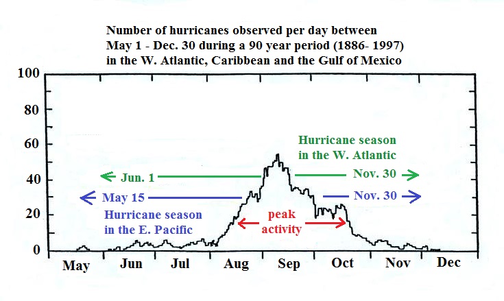
Hurricane season in the Atlantic officially runs from June 1 through to November 30 (hurricane season in the eastern Pacific begins two weeks earlier on May 16 and runs through the end of November).  The peak of hurricane season is in September.  In 2005, an unusually active hurricane season in the Atlantic, hurricanes continued through December and even into January 2006.  Hurricane names are determined several years in advance.  The list of names was used up in 2005 and six of the storms were given Greek letters as names.

Hurricane initiation - easterly waves
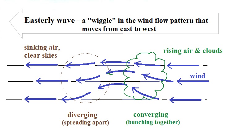
Some kind of meteorological process that produces low level convergence is needed to initiate a hurricane.  One possibility, and the one that fuels most of the strong N. Atlantic hurricanes, is an "easterly wave."  This is just a "wiggle" in the wind flow pattern. 


In some ways winds blowing through an easterly wave resembles traffic on a multi-lane highway.  Traffic will slow down and start to bunch up as it approaches an obstruction.  This is like the convergence that occurs when air flows into an easterly wave.  Once through the "bottleneck" traffic will begin to flow more freely.
  Easterly waves often form over Africa or just off the African coast and then travel toward the west across the N. Atlantic.  Winds converge as they approach the wave and then diverge once they are past it .  The convergence will cause air to rise and thunderstorms to begin to develop. 


Normal hurricane activity in the Pacific Normal hurricane activity in the Atlantic
16 tropical storms per year
8 reach hurricane strength
0 hit the US coastline
10 tropical storms per year
6 reach hurricane strength
2 hit the US coastline

2005 Atlantic hurricane season
(Katrina, Rita, Wilma)
28 named storms
(previous record was 21)
15 became hurricanes
(7 major hurricanes)

2017 Atlantic hurricane season
(Harvey, Irma, Maria)
2018 Atlantic hurricane season
(Michael)
17 named storms
10 became hurricanes
(6 major hurricanes)
15 named storms
8 became hurricanes
(2 major hurricanes)

In an average year, in the N. Atlantic, there will be 10 named storms (tropical storms or hurricanes) that develop during hurricane season. 

Low pressure & converging winds at the bottom of a hurricane, high pressure & diverging winds at the top
This is a reasonably important figure.  It tries to explain how a cluster of thunderstorms can organize and intensify into a hurricane.

1.  Converging surface winds pick up heat and moisture from the ocean.  These are the two main sources of energy for the hurricane.

2.   Rising air expands, cools, and thunderstorm clouds form.  The release of latent heat during condensation warms the atmosphere.  The core of a hurricane is warmer than the air around it.

3.   Pressure decreases more slowly with increasing altitude in the warm core of the hurricane.  The result is that pressure at the top center of the hurricane is higher than the pressure at the top edges of the hurricane (pressure at the top center is still lower than the pressure at the bottom center of the hurricane).  Upper levels winds diverge and spiral outward from the top center of the hurricane (you can sometimes see this on satellite photographs of hurricanes).

4.   The upper level divergence will cause the surface pressure at the center of the hurricane to decrease.  The speed of the converging surface winds increases and the storm intensifies.  The converging winds pick up additional heat and moisture which warms the core of the hurricane even more.  The upper level high pressure and the upper level divergence increase.  The increased divergence lowers the surface pressure even more.  The lower the surface pressure gets, the stronger the storm becomes.

As long as upper level divergence exceeds surface convergence, the storm will intensity
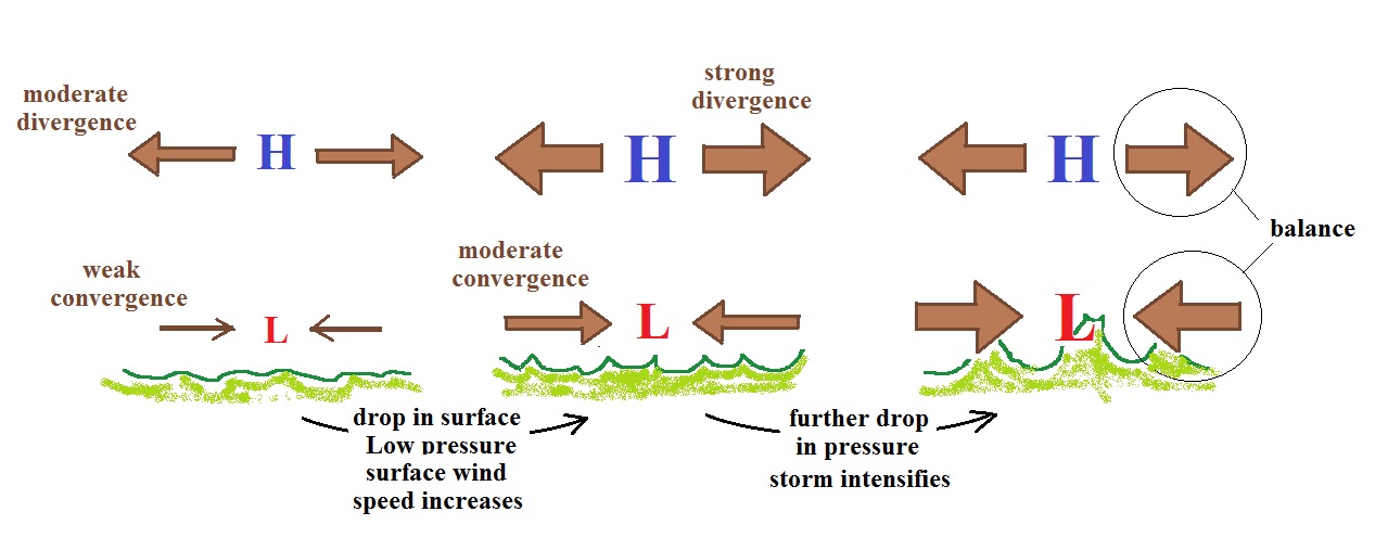
Here's another view of hurricane development and intensification.  It provides a different perspective on how the interplay between diverging winds at the top of a hurricane and decreasing surface pressure and strengthening winds at the bottom cause the storm to intensify.


In the figure at left the moderate divergence found at upper levels is stronger than the weak surface convergence.  Divergence is removing more air than is being added by surface convergence.  The surface low pressure will decrease.  The decrease in surface pressure will cause the converging surface winds to blow faster.

In the middle picture, the surface low pressure is lower, the surface convergence has strengthened to moderate levels.  The upper level divergence has also strengthened.  The upper level divergence is still stronger than the surface convergence so the surface low pressure will decrease even more and the storm will intensify.

In the right figure the surface low pressure has decreased enough that the strong surface convergence now balances the strong upper level divergence.  The storm won't strengthen any more.


A tropical disturbance is just a localized cluster of thunderstorms that a meteorologist might see on a satellite photograph.  But this would merit observation because of the potential for further development.  Signs of rotation would be evidence of organization and the developing storm would be called a tropical depression.


In order to be called a tropical storm the storm must strengthen a little more, and winds must increase to 35 knots.  The storm receives a name at this point.  Finally when winds exceed 75 MPH (easier to remember than 65 knots or 74 MPH) the storm becomes a hurricane.  You don't need to remember all these names, just try to remember the information highlighted above.


Generally speaking the lower the surface pressure at the center of a hurricane the stronger the storm and the faster the surface winds will blow.


This figure tries to show the relationship between surface pressure and surface wind speed.  The world record low sea level pressure reading, 870 mb, was set by Typhoon Tip off the SE Asia coast in 1979.  Sustained winds in that storm were 190 MPH.  Three 2005 Atlantic hurricanes: Wilma, Rita, and Katrina had pressures in the 880 mb to 900 mb range and winds ranging from 170 to 190 MPH.  Hurricane Patricia from Fall 2015, is now the 2nd strongest hurricane ever (central pressure dropped to 872 mb at one point and sustained winds exceeded 200 MPH).

The remainder of the material on hurricanes has been moved to the Monday, Apr. 22 notes