Quiz
3 Study Guide
(click here to
download the Study Guide in Microsoft WORD format)
Scattering
of light (see Mar. 14 notes).
The blue light we see coming from the sky is produced by scattering of
sunlight by air molecules. What is scattering? How do air
molecules scatter light differently from other particles in the
atmosphere such as cloud droplets or ice crystals?. What property
of air molecules is responsible for this ability to selectively scatter
light?
Tucson sunpath diagrams
(see handout in Mar. 14 notes).
Where does the sun rise and set at different times of the year in
Tucson? How does the length of the day (daylight hours) change
during the year in Tucson?
***
Online notes
or Chapter 3 (p. 63) ***
Controls
of Temperature
(Climate).
You should understand how latitude, proximity to land or ocean,
and
altitude affect the annual average temperature and the annual range of
temperature at a particular location. Where are the hottest and
coldest locations on earth?
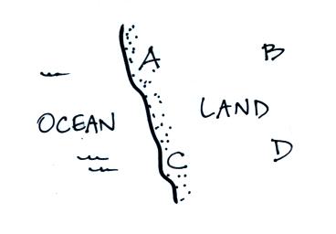
Which city in the figure above at left (all found at the same
altitude)
would have the hottest summertime temperatures? Which city would
have the coldest wintertime temperatures? Which city would have
the largest annual range of temperature? Which city would have
the smallest annual range of temperature?
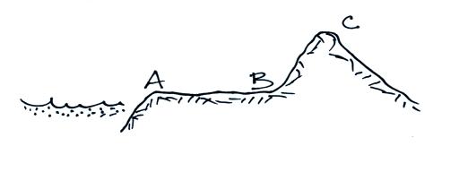
All three cities in the figure above at right are located at the same
latitude. Which city would have the smallest annual temperature
range? Which city would have the lowest annual average
temperature?
Which city would be hottest in the summer? Which city would be
coldest
in the winter?
Sample Questions (from the Fall 2000 Quiz Packet):
Quiz #3:
1, 10 Final: 29
Saturation. See Online
Notes. Saturation
is an upper limit to the amount of water
vapor that can be found in the air. The saturation mixing ratio is a
property of air and depends on the air temperature - there can be a lot
more water vapor
in warm air than in cold air. When air is saturated
with water
vapor, condensation balances evaporation. Click here
to test yourself on this topic.
Humidity variables. See Mar. 24 notes. Ways
of measuring or specifying the amount of
water vapor in the air.
mixing ratio (r) - the
actual amount of water vapor in air
expressed as grams of water vapor per kilogram of dry air (think about
what the units mean). This variable is not affected by
changes in air temperature (unless you cool air below its dew point
temperature) or pressure, it changes only when water
vapor is added to or removed from the air.
saturation
mixing ratio (rs) - the water vapor
capacity of the
air in grams of water vapor per kilogram of air. This property of
air depends on temperature; you can look the value of rs
in a chart
or on a graph.
relative
humidity (RH) - the amount of water vapor expressed as
a percentage of the maximum amount (the saturation amount):
RH =
100% x r / rs
RH does not really tell you how much water vapor is in the air.
The
saturation amount, rs,
depends on the air temperature
and you may
not know what that is. How can you change the RH? How would you
expect the RH to change during the day?
dew point
temperature (Td) - the temperature to
which you must
cool air in order for it to become saturated (RH becomes 100%). If
you know Td, you can
determine the mixing ratio (and
vice versa),
thus Td is a good measure of
the actual amount of water
vapor in the
air. A large difference between the air temperature and the dew point
temperature means the relative humidity is low. What is the RH when
the difference is small? When the difference is zero?
Click here
if you want to review
this material on humidity variables.
Miscellaneous. Cooling
moist air to below its dew point and then
warming it back up. Rain shadow effect. Why are relative humidities
indoors often very low in the wintertime (where did that indoors air
originate, did that air contain a lot, or not so much water vapor)?
Measuring relative humidity and dew point with a sling psychrometer.
Dry and wet bulb temperatures. Heat index (p. 89).
Here
are a couple of relatively tough
humidity questions to answer.
Sample Questions from the Quiz
Packet
Quiz #3: 3, 12, EC3 Final Exam:
1, 49
***
Chapter 4 (pps 91-92, 97-107) ***
Dew, frozen dew, frost.
How do these differ (what requirements are
there on the nighttime minimum temperature, Tmin, and dew point
temperature, Td)? What weather conditions favor
their
formation?
Cloud condensation nuclei (CCN).
What role do CCN play in cloud
formation? Typical sizes and concentrations. Hygroscopic nuclei.
Dry haze, wet haze, and fog. "Cloud in a bottle" demonstration.
Clouds clean the atmosphere.
Cloud identification and
classification. Ten cloud types. Clouds
are classified according to altitude and appearance; what key words
are used? You should be able to identify each of the 10 cloud types
in a picture (eg. Fig. 4.32) or from a written description (eg. high
altitude cloud with a filamentary appearance). How would you
distinguish between Cc, Ac, and Sc or between Cs and As? What cloud
type could produce a halo? Common features on thunderstorm clouds:
anvil, mammatus, shelf cloud.
Sample Questions from the Quiz
Packet Quiz #3: 9, 17
Quiz #4: 1, 4, 10, EC2 Final Exam: 8, 44, 50
***
Chapter 9 (pps 240-243) and/or Photocopied Notes (pps 99-100) ***
Satellite
Photographs. Infrared and
visible photographs. What do white and
grey on these two types of photographs represent? Thunderstorms
can produce severe weather; how would a thunderstorm appear on VIS and
IR photographs? How can satellites view clouds at night?
How is it possible to see air motions in regions where there aren't any
clouds? Geostationary and low-earth orbit satellites. Here
is a sample satellite photograph question.
Sample Questions from the Quiz
Packet Quiz
#4: 8, 16, EC1 Final Exam: 38
***
Chapter 5 (pps 121-137) ***
Formation of precipitation.
Approximate sizes of cloud condensation
nuclei, cloud droplets, and raindrops. It is relatively easy to form
cloud droplets (condensation); what about precipitation? Which of
the two processes below is the most important precipitation producing
process in the US?
Collision coalescence process.
Produces rain in warm clouds (clouds in the tropics with water
droplets only). Falling droplets collide (why?) and stick together.
Effects of cloud thickness and updraft speed on raindrop size. Which
cloud type produces the largest raindrops and the heaviest
precipitation? About how large can raindrops get (why don't they get
any larger)?
Ice crystal process.
Structure of a cold cloud. What are
supercooled water droplets? Where are they found in cold clouds?
Are there more water droplets or ice crystals in the mixed phase
region in a cold cloud? Are ice crystal nuclei abundant or scarce in
the atmosphere? Where does precipitation begin to form in a cold
cloud? Why are ice crystals able to grow while supercooled water
droplets do not? Riming (accretion). Graupel. Can the ice crystal
process produce rain or just frozen forms of precipitation?
Types of precipitation.
Rain, virga, snow (snowflakes), drizzle,
fall streaks, sleet (ice pellets), hail, freezing rain, graupel
("soft hail" or snow pellets). What type of cloud and special cloud
characteristics are needed for hail formation (see Fig. 5.35 on p.
134)?
Radar (time permitting).
Microwave
radiation is reflected by the precipitation size particles in a cloud;
ordinary radar locates the precipitation and provides an estimate of
its intensity. Doppler radar measures the shift in the frequency
of the reflected signal and can measure the speed of precipitation
particle motion toward or away from the radar antenna.
Sample Questions from the Quiz
Packet Quiz
#4:
6, 9, 12, 13, 15 Final Exam: 9, 40
Reviews
Monday Apr. 7
|
4-5 pm
|
FCS 225
|
Tuesday Apr. 8
|
4-5 pm
|
FCS 225
|
Wednesday Apr. 9
|
4-5 pm
|
FCS 225 |

