Mon., April 14, 2008
I didn't get a chance to grade the Expt. #4 reports this weekend,
SORRY. Too much around the house type work to be done. I
hope to have them done by Wednesday.
A couple more of the 1S1P Topic links are
now operative. The 1S1P reports are due by Friday this week.
The short Optional Assignment
handed out in class last Friday was collected today. You'll get
those back on Wednesday.
Tomorrow is April 15, the deadline to file your income taxes.
Many of you probably don't get the chance to try to read through and
understand the instructions and complete your own return. With
that kind of experience in mind, here's a worksheet and instructions
that will allow you to estimate your current grade in this class.
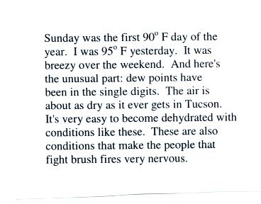
Something relatively unusual happened this past weekend (and has
continued into the early part of this week)
It would probably be best if I just told you what it was, but that
often goes in one ear and out the other.
I tried something different, went to the grocery store and bought the
following card.
 |
 |
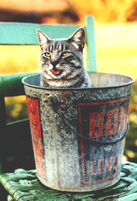
Have a close look at the cat, can you get any sense of what happened
over the weekend?
No? Well the message (the message is a little different from
the one shown in class) that was inside the card is shown above at
right.
Now look back at the cat. Doesn't the cat look like he(she?) was
a little hot and maybe thirsty?
Now that
today's moment of weirdness is over we can get on with the rest of the
class.
Today we are going to take a step backward and learn a little bit more
about thunderstorms. We do this so that we can eventually learn
what make tornadic thunderstorms different from more ordinary
thunderstorms that don't make tornadoes.
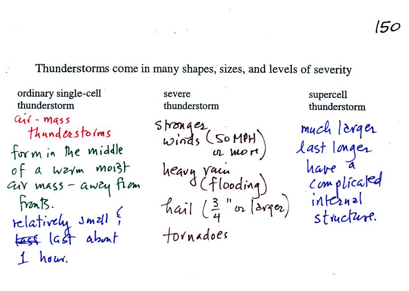
We'll first look at air mass thunderstorms. These are the kinds
of thunderstorms we see most of the time in Tucson.
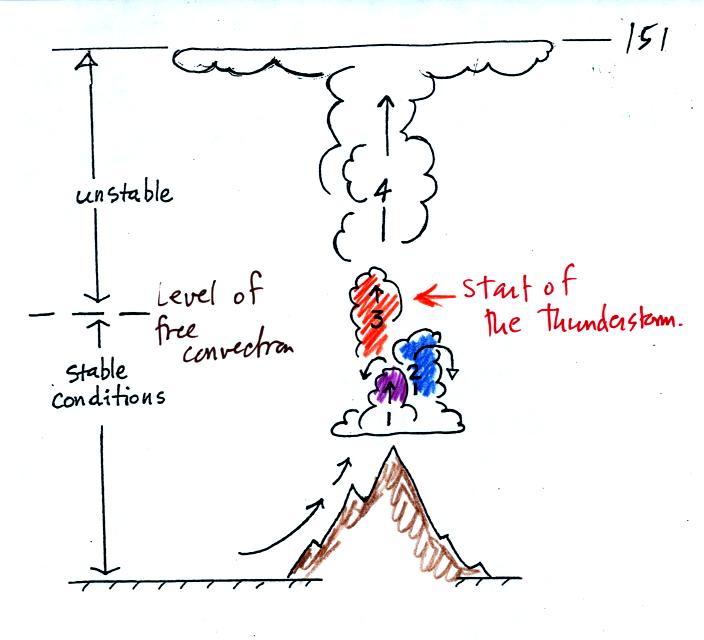
The top portion of this figure repeats what we discussed a
week or two ago (see the Wed., Apr. 02 online
notes) : it takes some effort and often a good part of
the
day before a thunderstorm forms. The air must be lifted to or
above the level of free convection. Once air is lifted above the
level of free convection it finds itself warmer and less dense that the
air around it and floats upward on its own. The is the moment at
which the air mass thunderstorm begins.
The thunderstorm then goes through 3 stages.
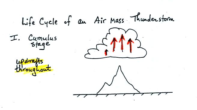
In
the first stage you would only find updrafts inside
the cloud.
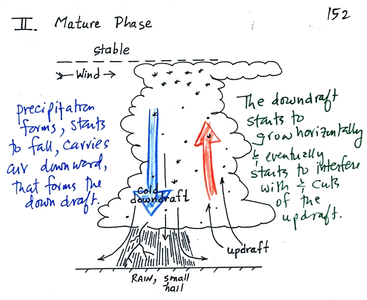
Once precipitation has formed and grown to a certain size,
it will
begin to fall and drag air downward with it. This is the
beginning of the
mature stage where you find both an updraft and a downdraft inside the
cloud. The falling precipitation will also pull in dry air from
outside the thunderstorm (this is called entrainment).
Precipitation will mix with this drier air and evaporate. The
evaporation will strengthen the downdraft (the
evaporation cools the air and makes it more dense). The
thunderstorm is strongest in the mature stage. This is when the
heaviest rain, strongest winds, and most of the lightning occur.
Eventually the downdraft spreads throughout the inside of the cloud and
interferes with or cuts off the updraft. This marks the beginning
of the end for this thunderstorm.
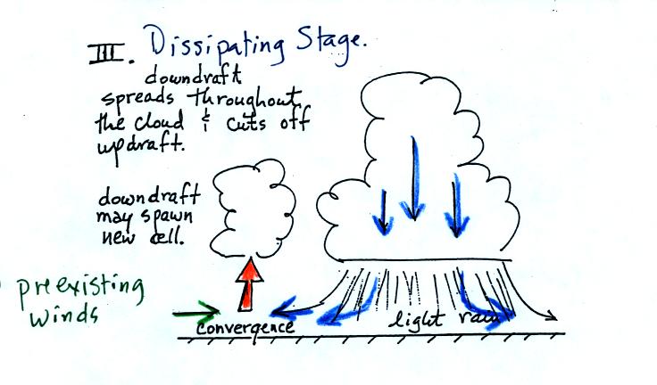
In the dissipating stage you
would only find weak downodrafts throughout the interior of the cloud.
Note how the winds from one thunderstorm can cause a region of
convergence on one side of the original storm and can lead to the
development of new storms. Preexisting winds refers to winds that
were blowing before the thunderstorm formed.
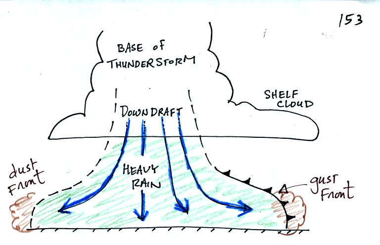
The cold downdraft air spilling out of a thunderstorm hits the ground
and begins to move outward from underneather the thunderstorm.
The leading edge of this outward moving air is called a gust
front. You can think of it as a dust front because that is what
it often causes in the desert southwest.
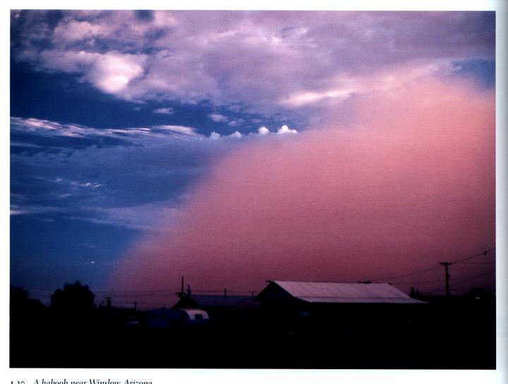
This is a picture of the dust cloud stirred up by thunderstorm gust
front winds. The gust front is moving from the right to the
left. Visibility in the dust cloud can drop to near zero which
makes this a serious hazard to automobile traffic. Dust storms
like this are sometimes called haboobs.
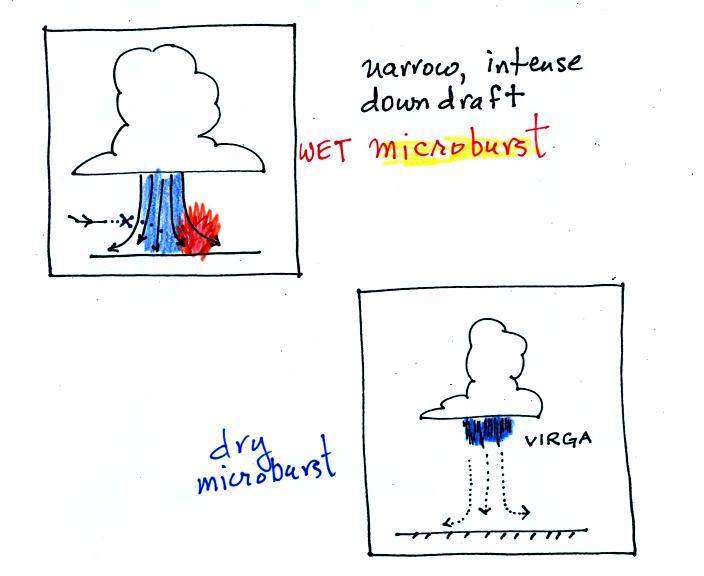
A narrow intense downdraft is called a microburst. At
the ground
microburst winds will sometimes reach 100 MPH (over a limited area);
most tornadoes have winds of 100
MPH or less. Microburst winds can damage homes (especially mobile
homes that aren't tied to the ground), uproot trees, and
seem to blow over a line of electric power poles at some point every
summer in Tucson. Microbursts are
a serious threat to aircraft especially when they are close to the
ground during landing or takeoff (see Fig. 10.15 in the text). An
inattentive pilot could quickly lose altitude and hit the ground.
Falling rain could warn of a (wet)
microburst.
In other cases, dangerous (dry) microburst winds might be invisible
(the virga, evaporating rain, will cool the air, make the air more
dense, and strengthen the downdraft winds).
A simple demonstration can give you an idea of what a
microburst
might
look like.
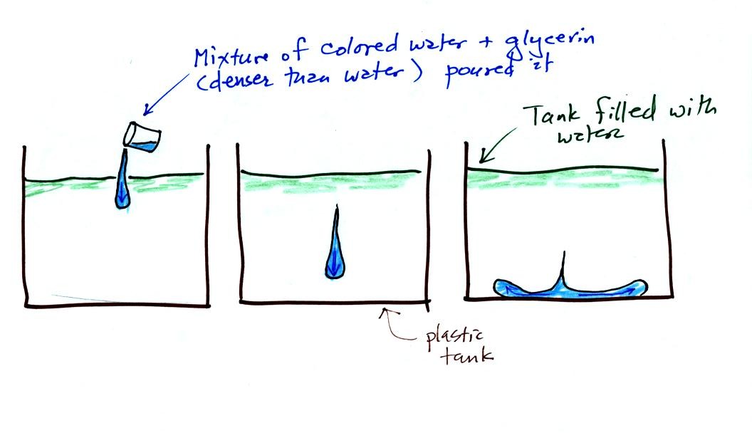
A large plastic tank was filled with water, the
water
represents air in the atmosphere. Then a colored mixture of water
and glycerin, which is a little denser than water, is poured into the
tank. This
represents the cold dense air in a thunderstorm downdraft. The
colored liquid sinks to the bottom of the tank and then spreads out
horizontally. In the atmosphere the cold downdraft air hits the
ground and spreads out horizontally. These are the strong
microburst winds that can reach 100 MPH.
The demonstration was followed with a short
time lapse
video showing a
microburst that occurred over the Santa Catalina mountains. Cold
air and rain suddenly fell out of a thunderstorm sank to the ground and
then spread out sideways. The surface winds could well have been
strong enough to blow down a tree or two.
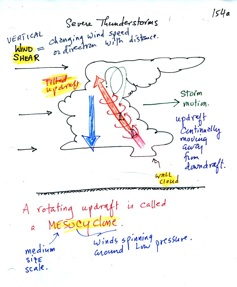
The winds are increasing in speed with increasing
altitude in the figure above. This is vertical wind shear
(changing wind direction
with altitude is also wind shear).
The thunderstorm will move to the right more
rapidly than the air in the thunderstorm updraft which originates at
the ground. Rising air that is situated at the front bottom edge
of the thunderstorm will find itself at the back edge of the storm when
it reaches the top of the cloud. This produces a tilted
updraft.
Remember that an ordinary air mass thunderstorm will begin to dissipate
when the downdraft grows horizontally and cuts off the updraft.
In a severe storm the updraft is continually
moving to the right and staying out of the downdraft's way.
Severe thunderstorms can get bigger, stronger, and last longer than
ordinary air mass thunderstorms. The strong updraft winds can
keep hailstones in the cloud longer which will allow them to grow
larger.
We will find that sometimes the tilted updraft will begin to
rotate. A rotating updraft is called a mesocyclone. Low
pressure in the core of the mesocyclone creates an inward pointing
pressure difference (pressure gradient) force that keeps the updraft
winds spinning in circular path (just as low pressure keeps winds
spinning in a tornado). The cloud that extends below
the cloud base and surrounds the mesocyclone is called a wall
cloud. The largest and strongest tornadoes will generally come
from the wall cloud.
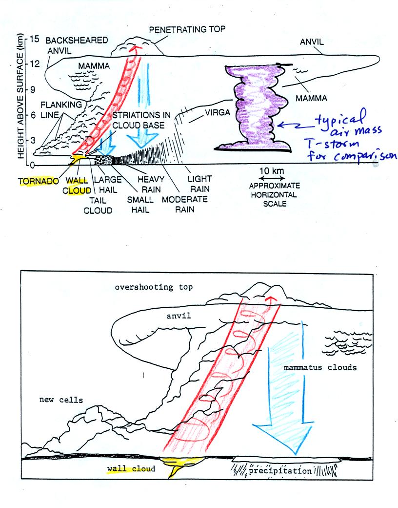
Sketches showing some of the characteristic features
of
supercell thunderstorms. Supercells are first of all much larger
than ordinary air mass
thunderstorms (a purple air mass T-storm is superimposed on the top
figure for comparison). In
an ordinary thunderstorm the updraft is unable to penetrate into the
very
stable air in the stratosphere. The upward moving air just
flattens out and forms an anvil. In a supercell the
rotating updraft (shown in orange above) is strong enough to penetrate
into the stratosphere. This
produces the overshooting top or dome feature above. A wall cloud
and a tornado are shown at the bottom of the mesocyclone. The
flanking line is a line of new cells trying to form alongside the
supercell thunderstorm.
A photograph of a distant supercell thunderstorm was shown
in the next
video tape. A computer simulation of the air motions inside a
supercell thunderstorm was also shown. Researchers understand the
development of a supercell pretty well. The exact process that
initiates tornado development is still unknown, however.
The next two figures weren't shown in
class.
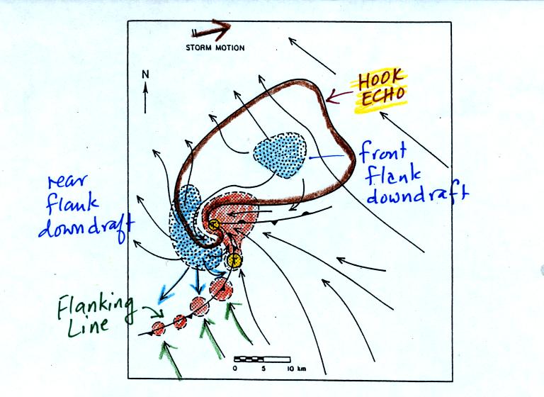
A radar picture of a supercell thunderstorm will often
have
a characteristic hook shape (outlined in brown above). The hook
is caused by spinning
motions inside the thunderstorm The large orange
shaded area is the
thunderstorm updraft, the mesoscylone. Smaller regions of rising
air are shown along a gust front.
Blue shaded areas show
where precipitation falls out of the cloud. The
flanking line of new cells is forming along the gust front produced
when
cold downdraft air from the thunderstorm (purple arrows) collides with
prexisting
winds (green arrows). Weak tornadoes can sometimes form along the
gust
front. The largest and strongest tornadoes come from the
mesocylone and wall cloud. The two tornado formation regions are
shaded yellow in the figure.
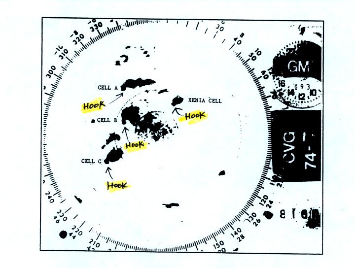
Actual radar display with 4 thunderstorms with
hook echoes. The hook echo feature is not always easy to
spot. The "Xenia cell" produced a large tornado.
The last video featured a tornado observed in Pampa, Texas and was
shown at this point. At one point the tornado winds just above
the ground were estimated at 250 MPH. Several vehicles (pickups
and a van) were seen on the video being thrown from the tornado cloud
at a height of about 100 feet at speeds of 80 to 90 MPH. Imagine
something like that coming down in your backyard.