Friday Mar. 28, 2008
Experiment #3 reports are due next Monday. You should already
have returned your materials.
Controls of Temperature
Optional Assignment due at the start of class next Monday
also. Humidity
Optional Assignment due next Wednesday.
I hope to make the final 1S1P assignment next week (reports will be due
a couple of weeks later).
I would love to have your input.

If there is a particular topic that you would like to see
included, please let me know.
A very preliminary version of the Quiz #3
Study Guide is now available.
Somehow
the good and surprising news that I mentioned last Friday turned into
"a surprise."
It's not a surprise, it's good news. And now I can tell you what
it is.
Do you remember the online notes concerning sunpath diagrams that I might have
told you to fear?
I have decided not to include that material on the next
quiz. That might not sound like good news, but trust me it is.
Still the news isn't quite as good as it could be, you will be
responsible for the material on the Fri., Mar. 14 handout.
Now
we do have to cover some material today. Actually several, what
might seem to be unrelated, subjects.
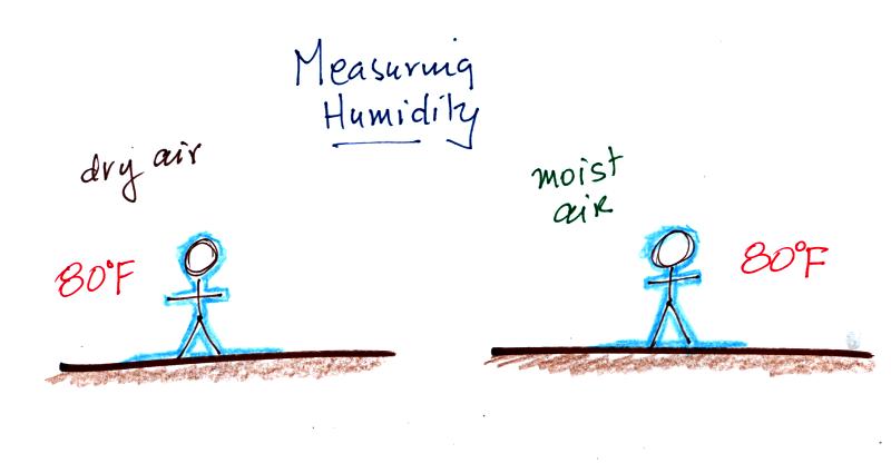
People are able to measure humidity. When wet you would feel
colder on a dry 80 F day than on a humid 80 F day.
A sling psychrometer is one of the ways humidity can be measured.
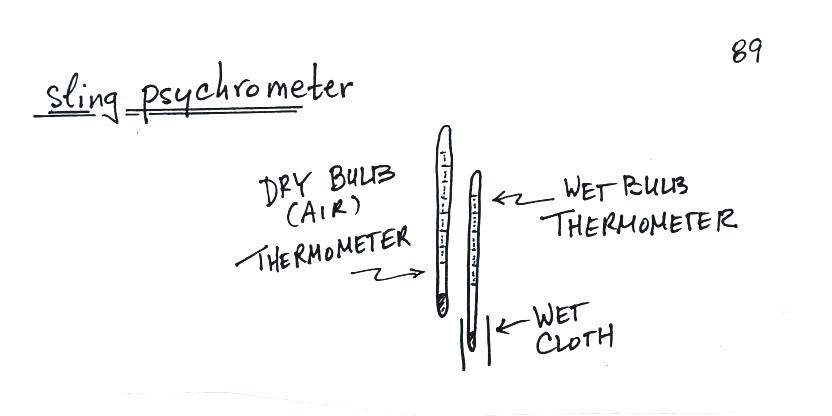
A sling
psychrometer consists of two thermometers mounted
side by side. One is an ordinary thermometer, the other is
covered with a wet piece of cloth. To
make a humidity measurement you swing the psychrometer around for a
minute or two and then read the temperatures from the two
thermometers. The dry - wet thermometer (dry and wet bulb)
temperature difference can be
used to determine relative humidity and dew point (see Appendix D at
the back of the textbook).
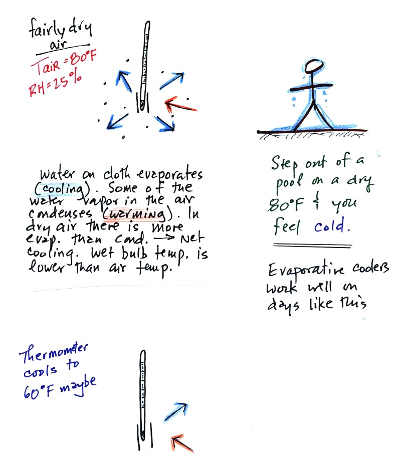
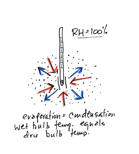
The figure at upper left shows what
will happen as you start to swing the wet bulb thermometer. Water
will begin to evaporate from the wet piece of cloth. The amount
or rate of evaporation will depend on the water temperature (the
80 F
value was just made up in this example). Warm water evaporates at
a higher rate than cool water. If you haven't already done so
(which I'm guessing you haven't) you might have a look at the online
notes concerning water
vapor saturation.
The evaporation is shown as blue arrows because this will cool the
thermometer. The same thing would happen if you were to step out
of a swimming pool on a warm dry day, you would feel cold. Swamp
coolers would work well on a day like this.
The figure at upper left also shows one arrow of condensation.
The amount or rate of condensation
depends on how much water vapor is
in the air surrounding the thermometer. In this case (low
relative humidity) there isn't much water vapor. The
condensation arrow is orange because the condensation will release
latent heat and warm the thermometer.
Because there is more evaporation (4 arrows) than condensation (1
arrow) the wet bulb thermometer will drop.
Note in the bottom left figure we imagine that the wet bulb thermometer
has cooled to 60 F. Because the wet piece of cloth is cooler,
there is less evaporation. The wet bulb thermometer has cooled to
a temperature where the evaporation and condensation are in
balance. The thermometer won't cool any further.
You
would measure a large difference (20 F) between the dry and wet bulb
thermometers on a day like this when the air is relatively dry.
The air temperature is the same in this
example, but there is more
water vapor in the air.
You wouldn't feel as cold if you stepped out of a pool on a warm humid
day like this. Swamp coolers wouldn't provide much cooling on a
day like this.
There are four arrows of evaporation (because the water temperature is
still 80 F just as it was in the previous example) and three arrows now
of
condensation (due to the increased amount of water vapor in the air
surrounding the thermometer). The wet bulb thermometer will cool
but won't get as
cold as in the previous example.
The wet bulb thermometer might well only cool to 75 F. This might
be enough to lower the rate of evaporation (from 4 arrows to 3 arrows)
enough to bring it into
balance with the rate of condensation.
You would measure a small difference (5 F) between the dry and wet bulb
thermometers on a humid day like this.
There won't be any difference in
the dry and wet bulb temperatures when
the
RH=100%. The rates at which water is evaporating and water vapor
is condensing are equal. The dry and wet bulb thermometers would
both read 80 F.
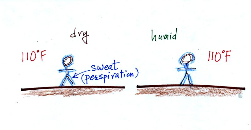
You've felt the cooling when you step out of a pool on a warm dry
day. You body tries to cool itself by perspiring during hot
weather. From the text: "over ten million sweat glands wet the
body with as much
as two liters of liquid per hour." When the relative humidity is
high, there might not be enough net evaporation to cool your
body. You might end up with heat stroke - a
potentially deadly
condition.
Just as wind and cold temperatures make it feel colder than it really
is,
a combination of high temperatures and high humidity make it feel
hotter than it is.
The wind chill temperature measures the effect of cold temperatures and
wind,
The heat index measures the effect of high temperatures and high
relative humidities.
Next we
will be covering some of the phenomena shown below:
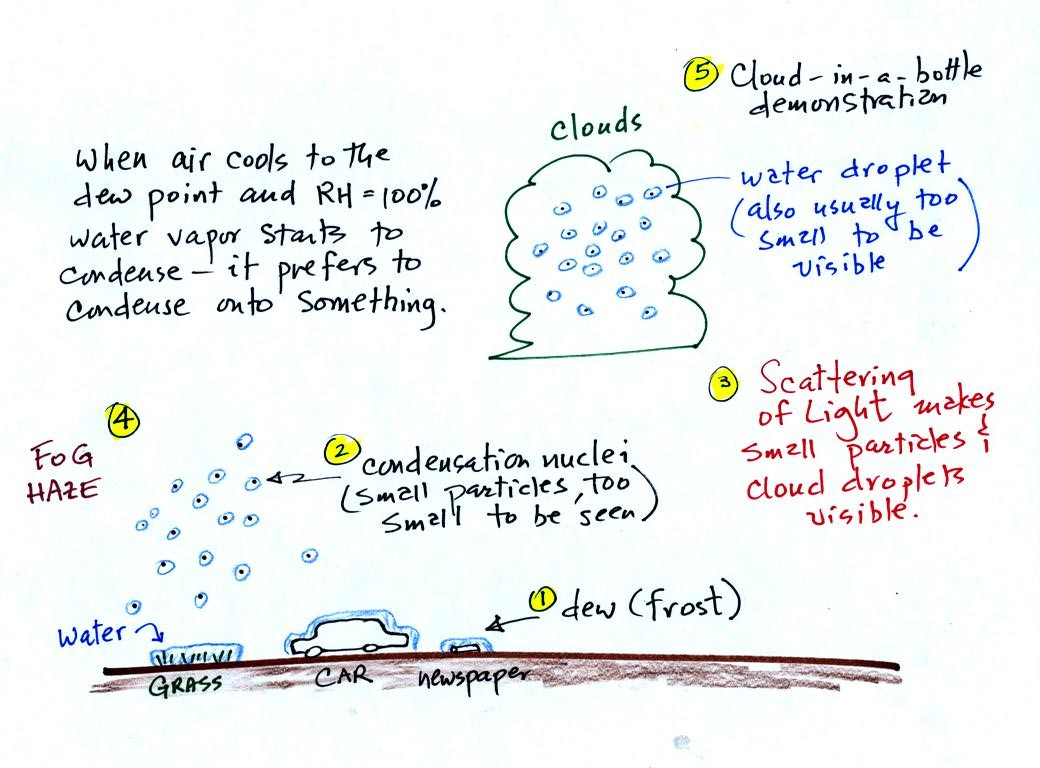
It turns out that it is much easier for water vapor to
condense
onto
something rather than just forming a small droplet of pure
water (you'll find some discussion of this on p. 92 in the photocopied
Class Notes, that's optional reading). Near the ground water
vapor will condense onto cold
objects on the ground (the grass, automobile, and newspaper
above). In air above the ground water vapor condenses onto small
particles in the air called condensation nuclei.
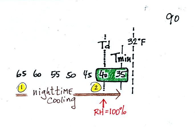
It might be a little hard to figure out what is being
illustrated
here. Point 1 is sometime in the early evening when the
temperature of the air at ground level is 65. By the next morning
the air has cooled to 35 F. When the air temperature reaches 40
F, the dew point, the relative humidity reaches 100% and water vapor
begins to condense onto the ground. You would find your newspaper
and your covered with dew the next morning.
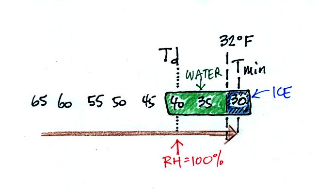
The next night is similar except that the nighttime minimum
temperature drops below freezing. The dew that covers everything
on the ground freezes and turns to ice. This isn't frost, rather
frozen dew. Because quite a bit of water vapor condensed and then
froze, the layer of ice on your automobile windshield can be thick and
difficult to scrape off.
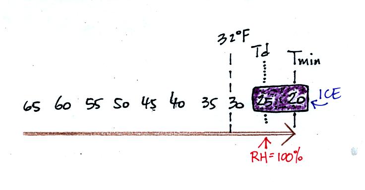
Now the dew point and the nighttime minimum temperature are both below
freezing. When the RH reaches 100% water vapor turns directly to
ice. This is frost.
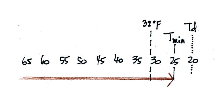
What happens on this night (what important point is not reached)?
This is what you usually find on your car or newspaper in the morning
here in Tucson.
When air
above the ground reaches 100% relative humidity it is much easier for
water vapor to condense onto small particles in the air called
condensation nuclei than to just form a small droplet of water.
There are hundreds even thousands of these small particles in every
cubic centimeter of air. We can't see them because they are so
small.
You can learn why it is so hard to form small droplets of pure water by
reading the top of p. 92 in the
photocopied class notes.
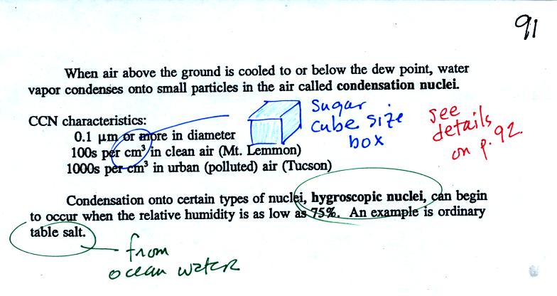
Water vapor will condense onto certain kinds of condensation
nuclei
even when the relative humidity is below 100% (again you will find some
explanation of this on the bottom of
p.
92). These are called hygroscopic
nuclei.
A short video showed how water vapor would, over time,
preferentially
condense onto small grains of salt rather than small spheres of glass.
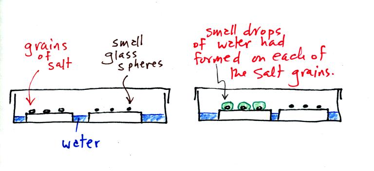
The start of the video at left showed the small grains of
salt were
placed on a platform in a petri dish
containing water. Some small spheres of glass were placed in the
same
dish. After about 1 hour small drops of water had formed around
each
of the grains of salt (shown above at right). The figure above wasn't shown in class.
In humid parts of the US, water will condense onto the grains of salt
in a salt shaker causing them to stick together. Grains of rice
apparently will keep this from happening and allow the salt to flow
freely out of the shaker when needed.
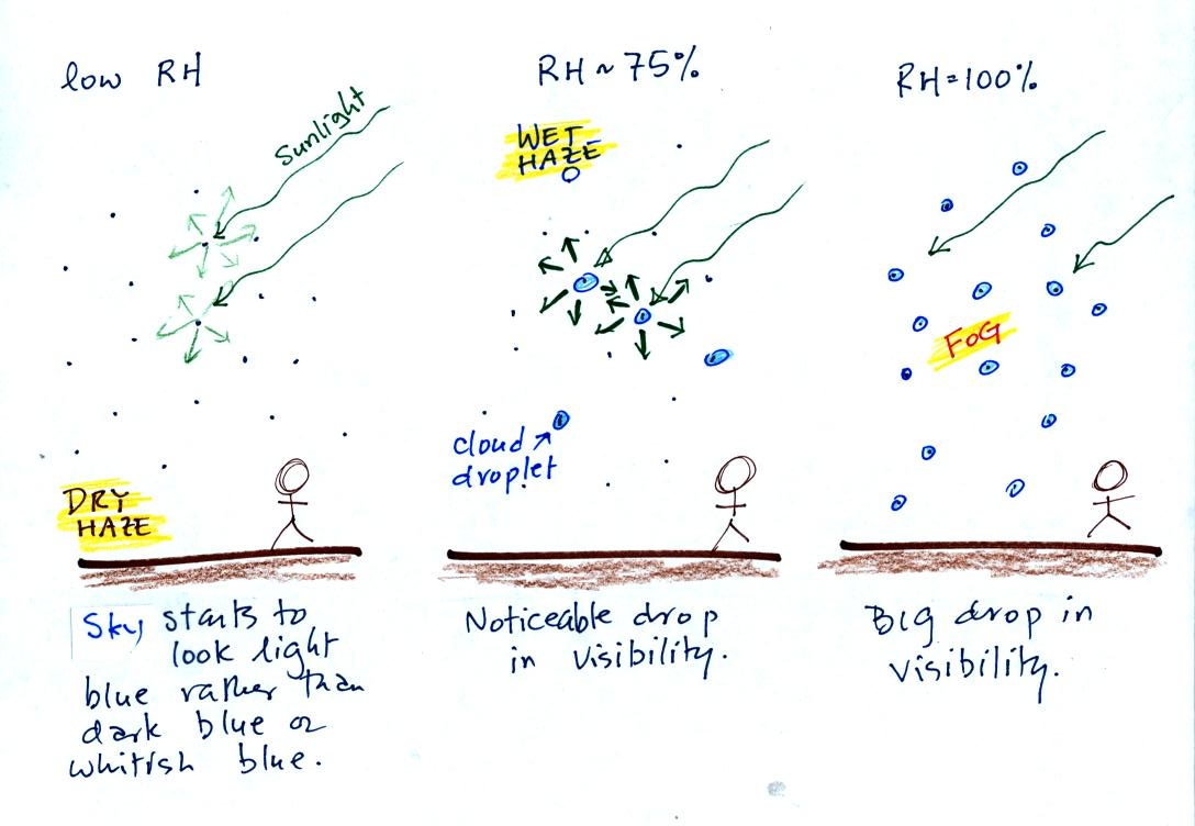
This figure (redrawn after class for improved clarity) shows
how
cloud
condensation nuclei and increasing relative humidity can affect the
appearance of the sky and the visibility.
The air in the left most figure is relatively dry. Even though
the condensation nuclei particles are too small to be seen with the
human eye you can tell they are there because they scatter
sunlight. When you look at the sky you see the deep blue color
caused by scattering of sunlight by air molecules mixed together with
some white
light scattered by the condensation nuclei. This changes
the color of the sky from a deep blue to a bluish white
color. The more particles there are the whiter the sky
becomes. This is called "dry haze."
The middle picture shows what happens when you drive from the dry
southwestern part of the US into the humid
southeastern US. One of the first things you would notice is the
hazier
appearance of the air and a decrease in visibility. Because the
relative humidity is high,
water vapor begins to condense onto some of the condensation nuclei
particles (the hygroscopic nuclei) in the air and forms small water
droplets. The water droplets scatter more sunlight than just
small particles alone. The increase in the amount of scattered
light is what gives the air its hazier appearance. This is called "wet
haze."
Finally when the relative humidity increases to 100% fog forms.
Fog can cause a severe drop in the visibility. The thickest fog
forms in dirty air that contains lots of condensation nuclei. We
will see this effect in the cloud-in-a-bottle demonstration coming up
next.
Cooling
air and
changing relative humidity, condensation nuclei, and scattering of
light are all involved in this demonstration.
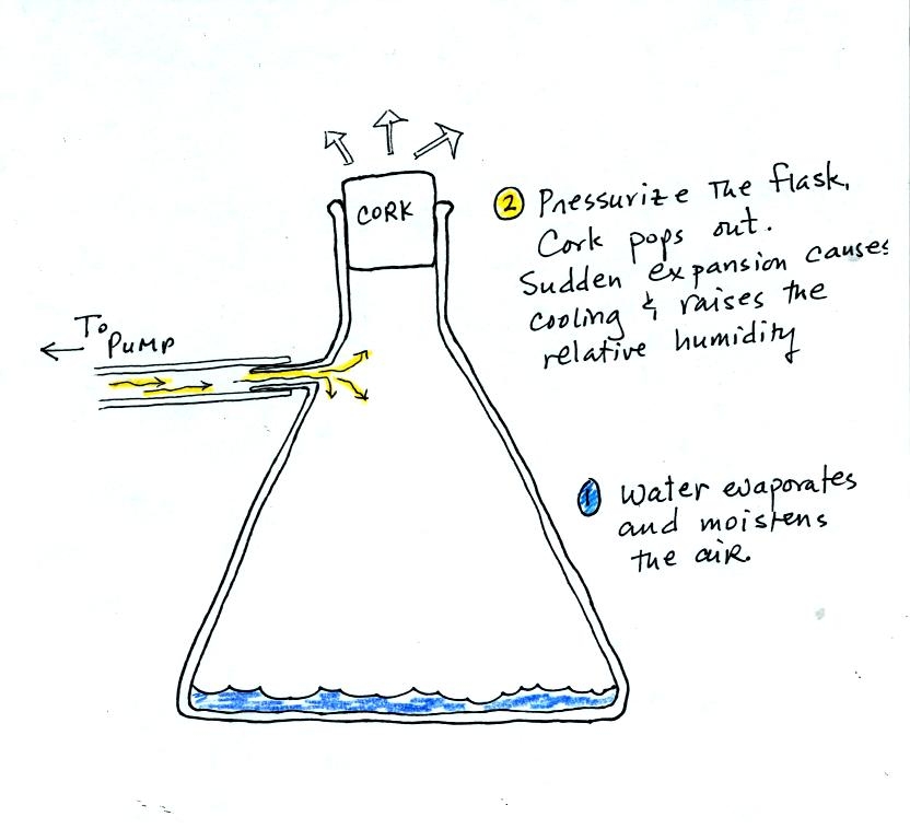
We used a strong thick-walled 4 liter flask (flasks
like this are designed not to implode when all of the air is pumped out
of them, they aren't designed not explode when pressurized).
There
was a little
water in the bottom of the flask to moisten the air in the flask.
Next we pressurized the air in the flask. At some point the
pressure blows the cork out of the top of the flask (hopefully).
The air in
the flask expands outward and cools. This sudden cooling
increases the
relative humidity of the moist air in the flask to 100% (probably more
than 100%) and water vapor condenses onto cloud condensation nuclei in
the air. A cloud became visible at this point. The
cloud droplets are too small to be seen with the human eye. You
can see the cloud because the water droplets scatter light.
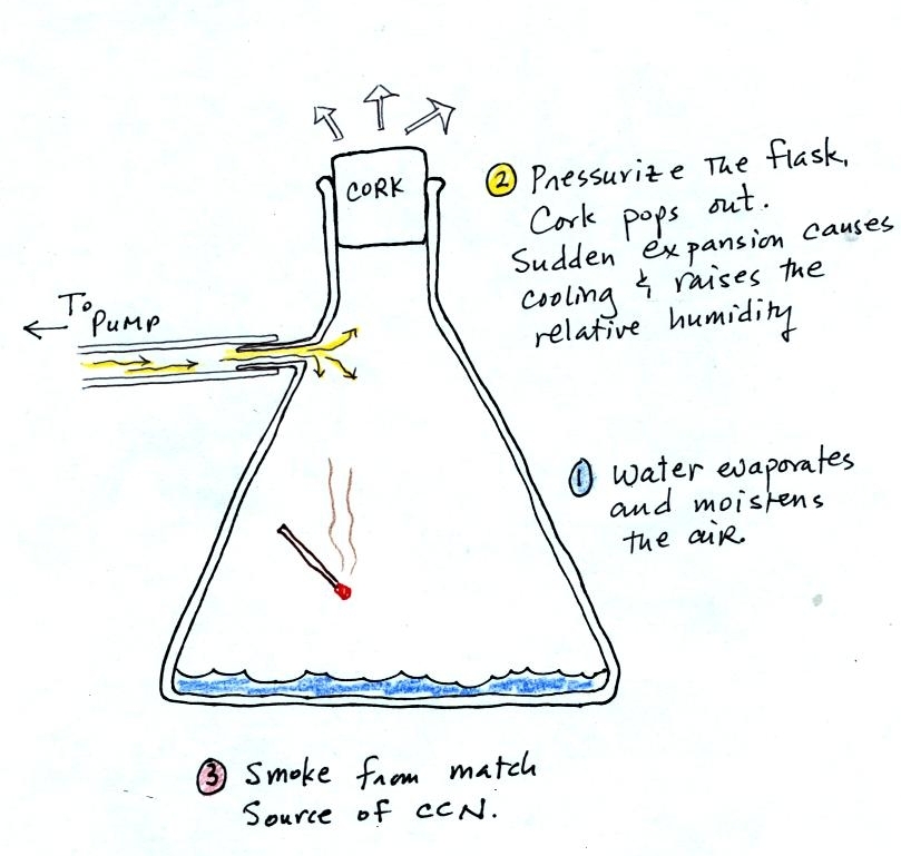
The demonstration was repeated an additional time with one
small
change. A burning match was dropped into the
bottle. The smoke from the match added lots of very small
particles, condensation nuclei, to the air in the flask. The
cloud that formed
this time was somewhat "thicker" and easier to see.
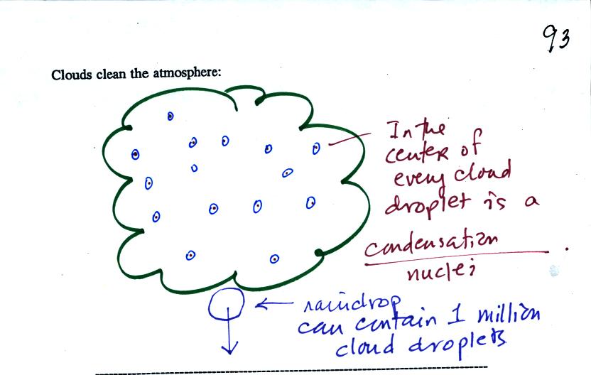
Clouds are one of the best ways of cleaning the
atmosphere
(cloud
droplets form on particles, the droplets clump together to form a
raindrop, and the raindrop carries the particles to the ground).
A raindrop can contain 1 million cloud droplets so a single raindrop
can remove a lot of particles from the air. You may have noticed
how clear the air seems the day after a rainstorm. Gaseous
pollutants can dissolve in the water droplets and be carried to
the ground by rainfall also.
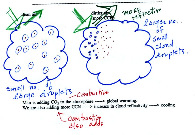
A cloud that forms in dirty air is composed of a large
number of small droplets (right figure above). This cloud is more
reflective
than a cloud that forms in clean air, that is composed of a smaller
number of larger
droplets (left figure).
This is has implications for climate change.
Combustion of fossil fuels adds carbon dioxide to the atmosphere.
There is concern that increasing carbon dioxide concentrations will
enhance the greenhouse effect and cause global warming.
Combustion also adds condensation nuclei to the atmosphere (just like
the burning match added smoke to the air in the flask). More
condensation nuclei might make it easier for clouds to form, might make
the clouds more reflective, and might cause cooling. There is
still quite a bit of uncertainty how clouds might change and how this
might affect climate (remember too that clouds are good absorbers of IR
radiation).