Wednesday Apr. 22, 2009
click here to download today's notes in
a more printer friendly format.
The most recent Optional Assignment was collected today. Because
the end of the semester is approaching quickly, any addtional optional
assignments will probably be in-class assignments.
Quiz #4 Study Guides Pt. 1 and Pt. 2 are now available.
One of the 1S1P Assignment #3 topics is now available. At least
one more topic will be added as soon as I can think of what it will be.
Music today was from Tesoro.
We'll
finish up the section on tornadoes today and just begin the section on
lightning.
We'll mostly be looking at tornado damage today.
Simplified,
Easy-to-Remember version of the Fujita Scale
winds < 100 MPH
F0
|
|
F1
|
roof
damage,
mobile home tipped over
|
microburst winds can cause this degree of damage
winds 100 to 200 MPH
F2
|
roof
gone,
outside walls still standing
|
F3
|
outside
walls gone,
inside walls intact
|
winds 200 to 300 MPH
F4
|
home
destroyed,
debris nearby
|
F5
|
home
destroyed,
debris carried away
|
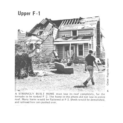
Here are some photographs of tornado damage
The buildings on the left suffered light roof
damage.
The barn
roof at right was more heavily damaged.
More severe damage to what
appears
to be a well built
house
roof.
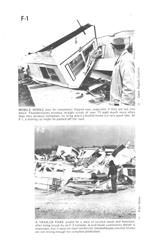
F1 tornado winds can tip over a mobile home if it is
not
tied down (the
caption states that an F1 tornado could blow a moving car off a
highway). F2 level winds (bottom photo above) can roll and
completely
destroy a
mobile home.
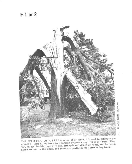
Trees, if not uprooted, can suffer serious damage from
F1 or
F2 tornado
winds.
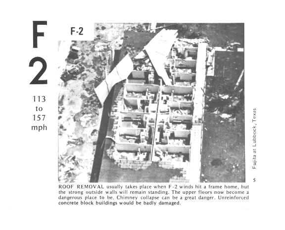
F2 level winds have completely removed the roof from
this
building. The outside walls of the building are still standing.
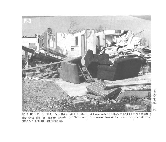
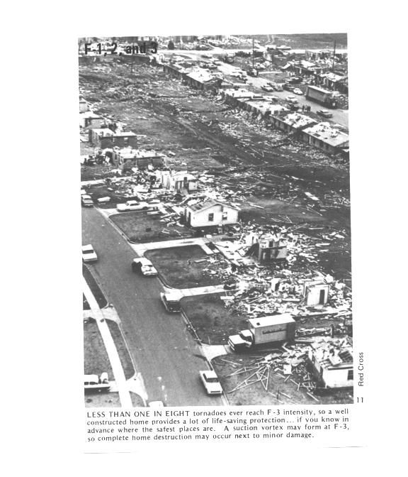
The roof is gone and the outer walls of this house were
knocked
down. This is characteristic of F3 level damage. In a house
without a basement or storm cellar it would be best to seek shelter in
an interior closet or bathroom (plumbing might help somewhat to keep
the walls intact).
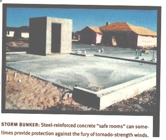
In some tornado prone areas,
people construct a small closet or room
inside their home made of reinforced concrete.
A better solution
might be to have a storm cellar located underground.
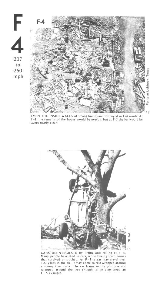
All of the walls were knocked down in the top photo but
the
debris is
left nearby. This is characteristic of F4 level damage. All
of the sheet metal in the car body has been removed in the bottom photo
and the car chasis has been bent around a tree. The tree has
been stripped of all but the largest branches.
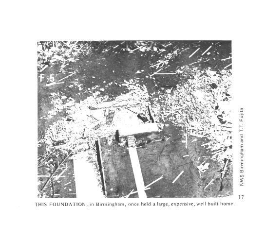
An F5 tornado completely destroyed the home in the
photo
above and
removed most of the debris.
Only bricks and a few pieces of
lumber are left.
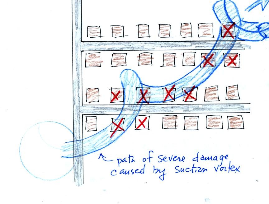
Several levels of damage are visible in the photograph
above. It
was
puzzling initially how some homes could be nearly destroyed while a
home nearby or in between was left with only light damage. One
possible explanation is shown below
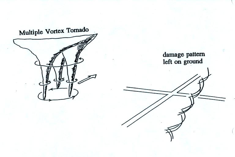
Some big strong tornadoes
may
have
smaller more intense "suction
vortices" that spin around the center of the tornado. Tornado
researchers have actually seen the scouring pattern shown at right in
the figure above that the multiple vortices can leave behind.
The
sketch above shows a tornado located SW of a neighborhood.
As the
tornado sweeps through the neighborhood, the suction vortex will
rotate around the core of the tornado.
The
homes marked in red would be damaged severely. The others
would receive less damage (remember, however that there would probably
be multiple suction vortices in the tornado).
The following figures, added in
response to a question from a student in class, weren't shown in
class.
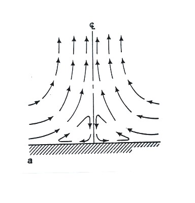
Air
motions inside tornadoes are complex and difficult (dangerous) to
study. Researchers resort to laboratory
simulations ("tornado machines") and computer models.
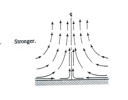
The
figure above shows what the winds are thought to be like in a weak
tornado.
Friction probably
causes the closed circulation loop near the bottom center of the
tornado.
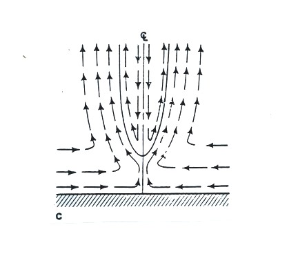
Winds
in a somewhat
stronger
tornado.
Downward
moving air is found in the core of
this tornado.
This tornado would also have a
larger diameter than
the weaker tornadoes above.
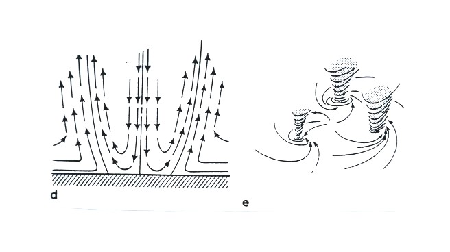
Vortex breakdown has
reached the
ground. Sinking air would normally result in clear skies.
There are a few firsthand reports of people being able to look upward
in the center of a tornado and seeing clear skies.
This vortex breakdown is what may lead to the
formation of multiple vortices.
At
this point we watched the last of the tornado video tapes. It
showed a tornado that occurred in Pampa, Texas. Near the end of
the segment, video photography showed several vehicles (pick up trucks
and a van) that had been lifted 100 feet or so off the ground that were
being thrown around at 80 or 90 MPH by the tornado
winds. Winds speeds of about 250 MPH were estimated from the
video photography.
Click on this link,
for a brief introduction to lightning, the next topic we will be
covering in this class.
Lightning kills about 100 people every year in the United
States (more than tornadoes or hurricanes but less than flooding,
summer heat and winter cold) and is the cause of about 30% of all power
outages. In
the western United States, lightning starts about half of all forest
fires. Lightning caused fires are a particular problem at the
beginning of the thunderstorm season in Arizona. At this time the
air underneath thunderstorms is still relatively dry. Rain
falling from a thunderstorm will often evaporate before reaching the
ground. Lightning then strikes dry ground, starts a fire, and
there isn't any rain to put out or at least slow the spread of the
fire. This is so called dry lightning.
Lighning is most commonly produced by thunderstorms (it has also
be observed in dust storms and volcanic eruptions).
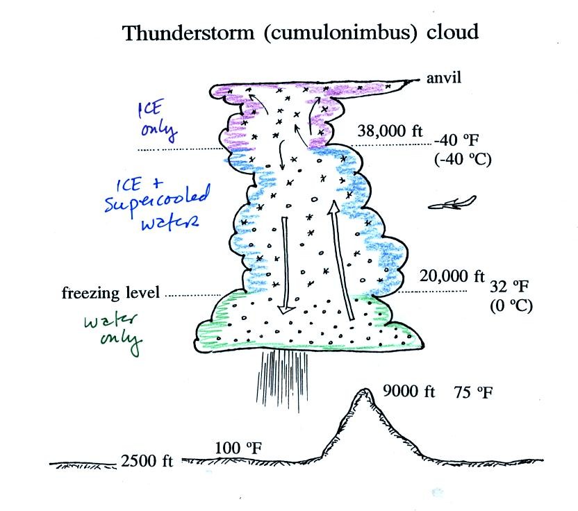
A typical summer thunderstorm in Tucson (found on p. 165 in the
photocopied Classnotes). Remember that
even in the summer
a large part of the middle of the middle of the cloud is found at below
freezing temperatures and contains a mixture of super cooled water
droplets and ice crystals. This is where the ice crystal process
of precipitation formation operatures and is also where electrical
charge is created. Doesn't it seem a little unusual that
electricity can be created in such a cold and wet environment?
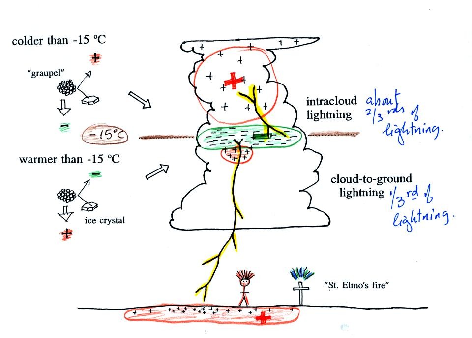
Collisions between precipitation
particles produce the
electrical charge needed
for lightning.
When temperatures are colder than -15 C, graupel becomes negatively
charged
after colliding with a snow crystal. The snow crystal is
positively charged and is carried up toward the top of the cloud by the
updraft winds. At temperature warmer than -15 (but still below
freezing), the polarities are reversed. Large positive and
negative
charge centers begin to build up inside the cloud. When the
electrical attrative forces between these charge centers gets
high enough lightning occurs.
Most
lightning (2/3 rds) stays inside the cloud and travels between the main
positive
charge center near the top of the cloud and a large layer of negative
charge in the middle of the cloud; this is intracloud lightning.
About 1/3 rd of all lightning
flashes strike the ground. These are called cloud-to-ground
discharges (actually negative cloud-to- ground lightning).
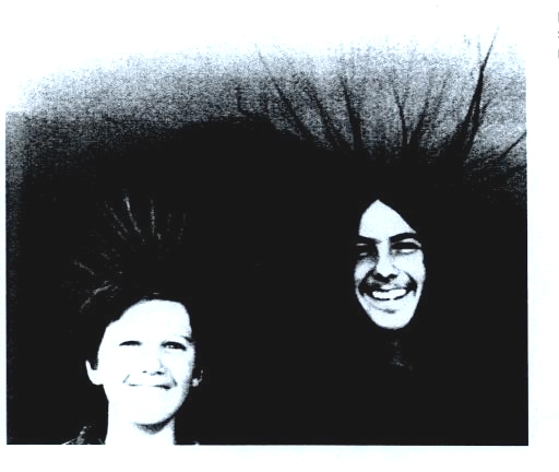
A couple of interesting things that can happen at the ground when
the
electrical forces get high enough. Attraction between positive
charge in the ground and the layer of negative charge in the cloud can
become strong enough that a person's hair will literally stand on
end. This is incidentally
a dangerous situation to be in as lightning might be about to
strike. St.
Elmo's fire is a faint
electrical discharge that sometimes develops at the tops of elevated
objects during thundestorms. It was first observed coming from
the tall masts of sailing ships at sea (St. Elmo is the patron saint of
sailors).